Citation:
Citation_Information:
Originator: R.W. Givler
Originator: R.E. Wells
Publication_Date: 2001
Title:
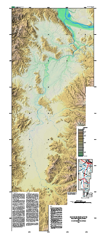
Shaded-relief and Color Shaded-relief maps of the Willamette Valley, Oregon
Edition: 1.0
Geospatial_Data_Presentation_Form: vector and raster digital data
Series_Information:
Series_Name: U.S. Geological Survey Open-File Report
Issue_Identification: 01-294
Publication_Information:
Publication_Place: Menlo Park, CA
Publisher: U.S. Geological Survey
Online_Linkage: http://pubs.usgs.gov/of/2001/0294/
Description:
Abstract:
This digital dataset was compiled from newly released U.S.
Geological Survey 10-meter digital elevation model (DEM) data,
along with stream and transportation coverages previously
published on the internet. This report consists of a digital
representation of the physiography of the Willamette Valley.
Contained in this dataset is: 1) 10-meter DEM data for the entire
Willamette Valley; 2) the ARC/INFO grids used to create the color
shaded-relief and gray scale shaded-relief images; 3) the
necessary data ARC/INFO data to used to plot these data; and 4)
several reports detailing the data formats (this docuement) and
producers used to create these datasets. The scale of the
original 10-meter DEM data should not be violated. Any use of
these original data smaller than the intended scale (1:24,000)
will not yield improved accuracy.
Purpose:
This digital data set, compiled from new 10-meter digital
elevation model (DEM) data, represents the physiography of the
Willamette Valley, Oregon. This new physiographic data is useful
because the improved resolution allows for better visualization
of flood and fluvial features in the low lying areas of the
Willamette Valley. Many scientist are interested in the
Willamette Valley because it is subject to a variety of
earthquake hazards, and its water and geologic resources are
under pressure from rapid urbanization (see sheets for a brief
description). Further, this Open-File report details the
techniques used to create these maps (See readme.pdf). It is the
author's purpose to publish these techniques and data so others
may use this report to generate their own gray scale and/or color
shaded-relief maps. All information about the data and methods
used to create this report are in the readme.pdf file and this
document.
Supplemental_Information:
The databases in this report were compiled in ARC/INFO, a
commercial Geographic Information System (Environmental Systems
Research Institute, Redlands, California, with version 3.0 of the
menu interface ALACARTE (Fitzgibbon and Wentworth, 1991,
Fitzgibbon, 1991, Wentworth and Fitzgibbon, 1991). The files are
in either GRID (ARC/INFO raster data) format or COVERAGE (ARC/
INFO vector data) format. Coverages are stored in uncompressed
ARC export format (ARC/INFO version 8.0.2). ARC/INFO export
files (files with the .e00 extension) can be converted into ARC/
INFO coverages in ARC/INFO (see below) and can be read by some
other Geographic Information Systems, such as MapInfo via ArcLink
and ESRI's ArcView (version 1.0 for Windows 3.1 to 3.11 is
available for free from ESRI's web site:
http://www.esri.com).
The digital compilation was done in version 8.0.2 of ARC/INFO
with version 3.0 of the menu interface ALACARTE (Fitzgibbon and
Wentworth, 1991, Fitzgibbon, 1991, Wentworth and Fitzgibbon,
1991). Custom AMLs were written to compile the 10-meter DEM data
from 7.5-minute quadrangles into large composite datasets. The
data was compiled as ARC/INFO grids and then converted to
decimeter integer grids. This procedure greatly reduces the file
sizes without downgrading the data quality. Stream coverages
were merged with the grids used to create the color shaded-relief
gridcomposite. Further details on the techniques used to
generate these maps are available in the readme file of this
report.
Time_Period_of_Content:
Time_Period_Information:
Single_Date/Time:
Calendar_Date: 2001
Currentness_Reference: publication date
Status:
Progress: Complete
Maintenance_and_Update_Frequency: As needed
Spatial_Domain:
Bounding_Coordinates:
West_Bounding_Coordinate: -123.30
East_Bounding_Coordinate: -122.125
North_Bounding_Coordinate: 45.75
South_Bounding_Coordinate: 43.50
Keywords:
Theme:
Theme_Keyword_Thesaurus: USGS Thesaurus
Theme_Keyword: geology
Theme_Keyword: topography
Theme_Keyword: geospatial datasets
Theme:
Theme_Keyword_Thesaurus: none
Theme_Keyword: geology
Theme_Keyword: Digital elevation model data
Theme_Keyword: DEM
Theme_Keyword: ARC/INFO
Theme_Keyword: color shade-relief
Theme_Keyword: shaded-relief
Theme_Keyword: Oregon Coast Range
Theme_Keyword: Cascade Range
Theme_Keyword: Willamette Valley, OR
Theme_Keyword: Missoula Floods
Theme_Keyword: Portland, Oregon
Theme_Keyword: Columbia River Basalt Group
Theme_Keyword: Willamette River
Theme_Keyword: Tualatin River
Theme_Keyword: Columbia River
Theme_Keyword: Clackamas River
Theme_Keyword: Calapooia River
Theme_Keyword: McKenzie River
Theme_Keyword: Middle Fork River
Theme_Keyword: Coast Fork River
Theme_Keyword: Tualatin Mountains
Theme_Keyword: Chehalem Mountains
Theme_Keyword: Salem Hills
Theme:
Theme_Keyword_Thesaurus: ISO 19115 Topic Categories
Theme_Keyword: geoscientificInformation
Place:
Place_Keyword_Thesaurus: none
Place_Keyword: Willamette Valley, Oregon
Place_Keyword: Portland, Oregon
Place_Keyword: Salem, Oregon
Place_Keyword: Corvallis, Oregon
Place_Keyword: Eugene, Oregon
Place:
Place_Keyword_Thesaurus: Augmented FIPS 10-4 and FIPS 6-4
Place_Keyword: f41009 = Columbia
Place_Keyword: f41057 = Tillamook
Place_Keyword: f41067 = Washington
Place_Keyword: f41051 = Multnomah
Place_Keyword: f41005 = Clackamas
Place_Keyword: f41071 = Yamhill
Place_Keyword: f41047 = Marion
Place_Keyword: f41053 = Polk
Place_Keyword: f41043 = Linn
Place_Keyword: f41003 = Benton
Place_Keyword: f41039 = Lane
Place_Keyword: f53011 = Clark
Access_Constraints: none
Use_Constraints:
Uses of this digital map should not violate the spatial resolution
of the data. Although the digital form of the data removes the
constraint imposed by the scale of a paper map, the detail and
accuracy inherent in map scale are also present in the digital
data. The fact that this database was edited for a scale of 1:24,
000 means that higher resolution information is not present in the
dataset. Plotting at scales larger than 1:24,000 will not yield
greater real detail, although it may reveal fine-scale
irregularities below the intended resolution of the database.
Similarly, where this database is used in combination with other
data of higher resolution, the resolution of the combined output
will be limited by the lower resolution of these data.
Point_of_Contact:
Contact_Information:
Contact_Organization_Primary:
Contact_Organization: U.S. Geological Survey
Contact_Person: Database Coordinator
Contact_Address:
Address_Type: mailing address
Address: 345 Middlefield Rd. MS-975
City: Menlo Park
State_or_Province: CA
Postal_Code: 94025
Country: USA
Contact_Voice_Telephone: 650-329-4935
Contact_Electronic_Mail_Address: [email protected]
Browse_Graphic:
Browse_Graphic:
Native_Data_Set_Environment: UNIX Sun Solaris; ESRI ArcInfo 8.0.2