Geologic Map of the Telegraph Peak 7.5' quadrangle, San Bernardino County, California

Metadata also available as - [Questions & Answers] - [Parseable text] - [XML]

Metadata:

Identification_Information:
Citation:
Citation_Information:
Originator: Douglas M. Morton
Originator: M.O. Woodburne
Originator: J.H. Foster
Publication_Date: 2001
Title:
Geologic Map of the Telegraph Peak 7.5' quadrangle, San Bernardino County, California
Edition: Version 1.0
Geospatial_Data_Presentation_Form: vector digital data
Series_Information:
Series_Name: U.S. Geological Survey Open-File Report
Issue_Identification: 01-293
Publication_Information:
Publication_Place: Menlo Park, California
Publisher: U.S. Geological Survey
Online_Linkage: http://pubs.usgs.gov/of/2001/0293/
Description:
Abstract:
This data set maps and describes the geology of the Telegraph 7.5' quadrangle, San Bernardino County, California. Created using Environmental Systems Research Institute's ARC/INFO software, the data base consists of the following items: (1) a double precision map coverage containing geologic contacts and units, (2) a coverage containing site-specific structural data, (3) a coverage containing geologic-unit label leaders and their associated attribute tables for geologic units (polygons), contacts (arcs), and site-specific data (points). In addition, the data set includes the following graphic and text products: (1) A PostScript graphic plot-file containing the geologic map, topography, cultural data, a Correlation of Map Units (CMU) diagram, a Description of Map Units (DMU), an index map, a regional geologic and structure map, and a key for point and line symbols; (2) PDF files of this Readme (including the metadata file as an appendix), Description of Map Units (DMU), and the graphic produced by the PostScript plot file.
The Telegraph Peak quadrangle is located in the eastern San Gabriel Mountains part of the Transverse Ranges Province of southern California. The generally east-striking structural grain characteristic of the crystalline rocks of much of the San Gabriel Mountains is apparent, but not well developed in the Telegraph Peak quadrangle. Here, the east-striking structural grain is somewhat masked by the northwest-striking grain associated with the San Andreas Fault zone.
Faults within the quadrangle include northwest-striking, right-lateral strike-slip faults of the San Andreas system. The active San Andreas Fault, located in the northern part of the quadrangle, dominates the younger structural elements. North of the San Andreas Fault is the inactive Cajon Valley Fault that was probably an early strand of the San Andreas system. It was active during deposition of the middle Miocene Cajon Valley Formation. South of the San Andreas, the Punchbowl Fault, which is probably a long-abandoned segment of the San Andreas Fault (Matti and Morton, 1993), has a sinuous trace apparently due to compression in the eastern San Gabriel Mountains that post-dates displacement on the fault. The Punchbowl Fault separates two major subdivisions of the Mesozoic Pelona Schist and is left-laterally offset by a northeast-striking fault in the northwestern part of the quadrangle. Within the Punchbowl Fault zone is a thin layer of highly deformed basement rock, which is clearly not part of the Pelona Schist. To the southeast, in the Devore quadrangle, this included basement rock attains a thickness of several hundred feet. Along strike to the northwest, Tertiary sedimentary rocks are included within the fault zone. South of the Punchbowl Fault are several arcuate (in plan) faults that are part of an antiformal schuppen-like fault complex of the eastern San Gabriel Mountains. Most of these arcuate faults are reactivated and deformed older faults, and probably include the eastern part of the San Gabriel Fault.
The Vincent Thrust of late Cretaceous or early Tertiary age separates the Pelona Schist in the lower plate from a heterogeneous basement complex in the upper plate. Immediately above the Vincent Thrust is a variable thickness of mylonitic rock generally interpreted as a product of displacement on the thrust. The upper plate includes two Paleozoic units, a schist and gneiss sequence and a schist, quartzite, and marble metasedimentary sequence. Both sequences are thrust over the Mesozoic Pelona Schist along the Vincent Thrust, and intruded by Tertiary (late Oligocene) granitic rocks, granodiorite of Telegraph Peak, that also intrude the Vincent Thrust. The Pelona Schist consists mostly of greenschist to amphibolite metamorphic grade meta-basalt (greenschist and amphibolite) and meta-graywacke (siliceous and white mica schist), with minor impure quartzite and marble, in which all primary structures have been destroyed and all layering transposed. Cretaceous granitic rocks, chiefly tonalite, intrude the schist and gneiss sequence, but not the Pelona Schist or the Vincent Thrust.
North of the San Andreas Fault, bedrock units consist of undifferentiated Cretaceous tonalite, here informally named tonalite of Circle Mountain, with some included small boldies of gneiss and marble. These basement rocks are the westward continuation of rocks of the San Bernardino Mountains and not rocks of the San Gabriel Mountains south of the San Andreas Fault. Also north of the San Andreas Fault are the Oligocene Vaqueros Formation, middle Miocene Cajon Valley Formation, and Pliocene rocks of Phelan Peak. The latter two formations are divided into several conglomerate and arkosic sandstone subunits. In the northeastern corner of the quadrangle, the rocks of Phelan Peak are unconformably overlain by the Quaternary Harold Formation and Shoemaker Gravel. Quaternary units ranging from early Pleistocene to recent are mapped, and represent alluvial fan, landslide, talus, and wash environments.
The geologic map database contains original U.S. Geological Survey data generated by detailed field observation and by interpretation of aerial photographs. This digital Open-File map supercedes an older analog Open-File map of the quadrangle, and includes extensive new data on the Quaternary deposits, and revises some fault and bedrock distribution within the San Gabriel Mountains. The digital map was compiled on a base-stable cronoflex copy of the Telegraph 7.5' topographic base and then scribed. This scribe guide was used to make a 0.007 mil blackline clear-film, from which lines and point were hand digitized. Lines, points, and polygons were subsequently edited at the USGS using standard ARC/INFO commands. Digitizing and editing artifacts significant enough to display at a scale of 1:24,000 were corrected. Within the database, geologic contacts are represented as lines (arcs), geologic units as polygons, and site-specific data as points. Polygon, arc, and point attribute tables (.pat, .aat, and .pat, respectively) uniquely identify each geologic datum.
Purpose:
The data set for the Telegraph 7.5' quadrangle was prepared under the U.S. Geological Survey Southern California Areal Mapping Project (SCAMP) and the California Division of Mines as part of an ongoing effort to develop a regional geologic framework of southern California, and to utilize a Geographical Information System (GIS) format to create regional digital geologic databases. These regional databases are being developed as contributions to the National Geologic Map Database of the National Cooperative Geologic Mapping Program of the USGS.
The digital geologic map database for the Telegraph 7.5' quadrangle has been created as a general-purpose data set that is applicable to other land-related investigations in the earth and biological sciences. For example, the U.S. Forest Service, San Bernardino National Forest, may use the map and database as a basic geologic data source for soil studies, mineral resource evaluations, road building, biological surveys, and general forest management. The database is not suitable for site-specific geologic evaluations at scales greater than 1:24,000 (1 in = 2,000 ft).
Time_Period_of_Content:
Time_Period_Information:
Range_of_Dates/Times:
Beginning_Date: 19740401
Ending_Date: 19810801
Currentness_Reference: New data and previously published data
Status:
Progress: Complete
Maintenance_and_Update_Frequency: As needed
Spatial_Domain:
Bounding_Coordinates:
West_Bounding_Coordinate: -117.6250927
East_Bounding_Coordinate: -117.4999073
North_Bounding_Coordinate: 34.37499995
South_Bounding_Coordinate: 34.24998407
Keywords:
Theme:
Theme_Keyword_Thesaurus: USGS Thesaurus
Theme_Keyword: geology
Theme_Keyword: geologic maps
Theme_Keyword: geologic structure
Theme_Keyword: bedrock geologic units
Theme_Keyword: surficial geologic units
Theme_Keyword: geospatial datasets
Theme:
Theme_Keyword_Thesaurus: none
Theme_Keyword: San Andreas Fault
Theme_Keyword: San Jacinto Fault
Theme_Keyword: San Gabriel Mountains
Theme_Keyword: Pelona Schist
Theme:
Theme_Keyword_Thesaurus: ISO 19115 Topic Categories
Theme_Keyword: geoscientificInformation
Place:
Place_Keyword_Thesaurus: none
Place_Keyword: California
Place_Keyword: San Bernardino County
Place_Keyword: Telegraph 7.5' quadrangle
Place:
Place_Keyword_Thesaurus: Augmented FIPS 10-4 and FIPS 6-4
Place_Keyword: f06071 = San Bernardino
Access_Constraints: None
Use_Constraints:
The Telegraph 7.5' geologic-map database should be used to evaluate and understand the geologic character of the Telegraph 7.5' quadrangle as a whole. The data should not be used for purposes of site-specific land-use planning or site-specific geologic evaluations. The database is sufficiently detailed to identify and characterize geologic materials and structures. However, it is not sufficiently detailed for site-specific determinations.
Use of this digital geologic map database should not violate the spatial resolution of the data. Although the digital form of the data removes the constraint imposed by the scale of a paper map, the detail and accuracy inherent in map scale are also present in the digital data. The fact that this database was compiled and edited at a scale of 1:24,000 means that higher resolution information may not have been uniformly retained in the dataset. Plotting at scales larger than 1:24,000 will not yield greater real detail, although it may reveal fine-scale irregularities below the intended resolution of the database. Similarly, although higher resolution data is incorporated in parts of the map, the resolution of the combined output will be limited by the lower resolution data.
Point_of_Contact:
Contact_Information:
Contact_Person_Primary:
Contact_Person: Douglas M. Morton
Contact_Organization:
U.S. Geological Survey, Western Region, Earth Surface Processes Team
Contact_Position: Project geologist
Contact_Address:
Address_Type: mailing address
Address:
U.S. Geological Survey
Department of Earth Science
University of California, Riverside
City: Riverside
State_or_Province: California
Postal_Code: 92521
Country: United States of America
Contact_Voice_Telephone: (909) 276-6397
Contact_Facsimile_Telephone: (909) 276-6295
Contact_Electronic_Mail_Address: scamp@usgs.gov
Browse_Graphic:
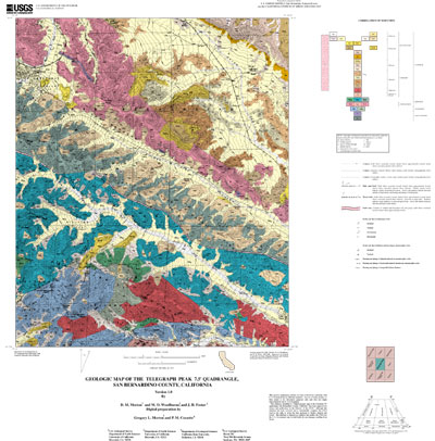
Browse_Graphic_File_Name: http://pubs.usgs.gov/of/2001/0293/images/tel_map.jpg
Browse_Graphic_File_Description:
Non-navigable image of the geologic map, topographic base, Correlation of Map Units, Description of Map Units and key to point and line symbols. 400x406 pixels, 32-bit RGB true color, 54k bytes.
Browse_Graphic_File_Type: JPEG
Browse_Graphic:
Browse_Graphic_File_Name: http://pubs.usgs.gov/of/2001/0293/pdf/tel_map.pdf
Browse_Graphic_File_Description:
Navigable portable document file image of the geologic map, topographic base, Correlation of Map Units, Description of Map Units and key to point and line symbols.
Browse_Graphic_File_Type: PDF
Data_Set_Credit:
Technical review by Michael Kennedy led to significant improvements that eventually were reflected in aspects of the database, the plot file, and in the description of the geologic units of the Telegraph 7.5' quadrangle.
Geologic mapping and digital preparation of this report were sponsored jointly by (1) the National Cooperative Geologic Mapping Program of the U.S. Geological Survey, (2) the California Division of Mines and Geology, and (3) the Southern California Areal Mapping Project (SCAMP). In our digital preparation of the data set, carried out in the SCAMP Geographic Information System laboratory at the University of California, Riverside by Gregory Morton, and in the USGS Geographic Information System laboratory of the Mineral Resources Program of the U.S. Geological Survey in Spokane, Washington by Pamela M. Cossette, we received valuable assistance from Rachel Alvarez in Riverside, California, and from Paul C. Hyndman in Spokane, Washington.
Native_Data_Set_Environment:
SunOS, 5.7, sun4u UNIX ARC/INFO version 7.2.1
Cross_Reference:
Citation_Information:
Originator: D.M. Morton
Publication_Date: 1976
Title:
Geologic map of the Cucamonga fault zone between San Antonio Canyon and Cajon Creek, southern California
Edition: Version 1.0
Geospatial_Data_Presentation_Form: paper map
Series_Information:
Series_Name: U.S. Geological Survey Open-File Report
Issue_Identification: 76-726
Publication_Information:
Publication_Place: Menlo Park, California
Publisher: U.S. Geological Survey
Data_Quality_Information:
Attribute_Accuracy:
Attribute_Accuracy_Report:
Geologic-map units in the Telegraph quadrangle database were described using standard field methods. Consistent with these methods, the database author has assigned standard geologic attributes to geologic lines, points, and polygons identified in the database.
Nation-wide geologic-map accuracy standards have not been developed and adopted by the U.S. Geological Survey and other earth-science entities. Until such standards are adopted, the SCAMP project has developed internal map-accuracy standards for 1:24,000-scale geologic maps produced by the project.
Geologic lines and points on 1:24,000 scale geologic maps are judged to meet SCAMP's internal map-accuracy standards if they are located to within +/-15 meters, relative to topographic or cultural features on the base map.
Lines and points that meet (or may not meet) this SCAMP internal map-accuracy standard are identified both in the digital database and on derivative geologic-map plots. Within the database, line and point data that are judged to meet the SCAMP internal map-accuracy standard are denoted by the attribute code .MEE. (meets) in the appropriate data table; line and point data that may not meet the SCAMP internal map-accuracy standard are denoted by the attribute code .MNM. (may not meet).
On any derivative geologic-map plot, line data that are judged to meet the SCAMP internal map-accuracy standard are denoted by solid lines; line data that may not meet the SCAMP internal map-accuracy standard are denoted by dashed or dotted lines. There is no cartographic device for denoting the map-accuracy for geologic-point data (eg. symbols representing bedding, foliation, lineations, etc.).
Logical_Consistency_Report:
Polygon and chain-node topology present.
The areal extent of the map is represented digitally by an appropriately projected (Polyconic projection), mathematically generated box. Consequently, polygons intersecting the lines that comprise the map boundary are closed by that boundary. Polygons internal to the map boundary are completely enclosed by line segments which are themselves a set of sequentially numbered coordinate pairs. Point data are represented by coordinate pairs.
Completeness_Report:
The geologic map and digital database of the Telegraph 7.5' quadrangle contain new data that have been subjected to rigorous review and are a substantially complete representation of the current state of knowledge concerning the geology of the quadrangle.
Positional_Accuracy:
Horizontal_Positional_Accuracy:
Horizontal_Positional_Accuracy_Report:
The maximum transformation RMS error acceptable for 7.5' quadrangle transformation and data input is 0.003 (7.6 meters). Horizontal positional accuracy was checked by visual comparison of hard-copy plots with base-stable source data.
Lineage:
Process_Step:
Process_Description:
Field mapping and aerial photograph interpretation; iterative process (D.M. Morton).
Process_Date: 1977 to 1978 and 1988 to 1989
Process_Step:
Process_Description:
Aerial photograph interpretation and limited field checking; iterative process (D.M. Morton).
Process_Date: 1989
Process_Step:
Process_Description:
Transfer of geologic linework and point data from field maps and aerial photographs to a scale-stable cartographic base of quadrangle (scribeguide) (D.M. Morton).
Process_Date: 1978 and 1989
Process_Step:
Process_Description:
Description of Map Units and Correlation of Map Units (D.M. Morton).
Process_Date: 1997
Process_Step:
Process_Description:
The geologic map information was hand digitized from a clear-film, right-reading, 0.007 mil thickness, base-stable blackline positive (made by contact photograph from a scribeguide) of the authors-prepared geologic map at 1:24,000 scale (G. Morton).
Process_Date: 1997
Process_Step:
Process_Description:
ARC/INFO database established; cleanup of digitizing artifacts; polygon, arc, and point attribute tables established using model developed for SCAMP coverages. Digitizing and editing artifacts significant enough to display at a scale of 1:24,000 were corrected (P.M. Cossette).
Process_Date: 1997, 1998 and 2001
Process_Step:
Process_Description:
First draft of metadata created by Cossette using FGDCMETA.AML ver. 1.2 05/14/98 on ARC/INFO data set /pool5/c/cossette2/telegraph/tel_geo420a
Process_Date: 20010420
Process_Step:
Process_Description: Creation of original metadata record
Process_Date: 20010917
Process_Contact:
Contact_Information:
Contact_Organization_Primary:
Contact_Organization: U.S. Geological Survey
Contact_Person: Pamela M. Cossette
Contact_Position: Geographer
Contact_Address:
Address_Type: mailing address
Address:
U.S. Geological Survey
West 904 Riverside Avenue
City: Spokane
State_or_Province: Washington
Postal_Code: 99201-1087
Country: USA
Contact_Voice_Telephone: 509-368-3123
Contact_Facsimile_Telephone: 509-368-3199
Contact_Electronic_Mail_Address: pcossette@usgs.gov
Spatial_Data_Organization_Information:
Direct_Spatial_Reference_Method: Vector
Point_and_Vector_Object_Information:
SDTS_Terms_Description:
SDTS_Point_and_Vector_Object_Type: Point
Point_and_Vector_Object_Count: 720
SDTS_Terms_Description:
SDTS_Point_and_Vector_Object_Type: String
Point_and_Vector_Object_Count: 1940
SDTS_Terms_Description:
SDTS_Point_and_Vector_Object_Type: GT-polygon composed of chains
Point_and_Vector_Object_Count: 721
Spatial_Reference_Information:
Horizontal_Coordinate_System_Definition:
Planar:
Map_Projection:
Map_Projection_Name: Polyconic
Polyconic:
Longitude_of_Central_Meridian: -117.5625
Latitude_of_Projection_Origin: 34.25
False_Easting: 0.00000
False_Northing: 0.00000
Planar_Coordinate_Information:
Planar_Coordinate_Encoding_Method: coordinate pair
Coordinate_Representation:
Abscissa_Resolution: 0.0027669065166
Ordinate_Resolution: 0.0027669065166
Planar_Distance_Units: Meters
Geodetic_Model:
Horizontal_Datum_Name: North American Datum of 1927
Ellipsoid_Name: Clarke 1866
Semi-major_Axis: 6378206.4
Denominator_of_Flattening_Ratio: 294.98
Entity_and_Attribute_Information:
Overview_Description:
Entity_and_Attribute_Overview:
Version 1.0 of the Telegraph 7.5' quadrangle comprises three ARC/INFO coverages, of which two contain geologic data, and one contains cartographic features: tel_geo (geology), tel_str (structural point data), and tel_ldr (annotation leaders). Two INFO tables, lines.rel and points.rel provide a full description of each of the geologic line and point features in the database. A full source citation is provided in the Entity_and Attribute_Detail_Citation section of this metadata document.
Geologic data represented by line entities and the polygons they delineate are contained in the coverage TEL_GEO. For display purposes, the geology coverage contains two annotation subclasses: anno.geo contains unit labels, and anno.fault contains formal, fault names.
Geological point data includes site-specific information describing the types and the orientation of bedding, foliation, and lineations. One annotation subclass is included in the geologic points coverage, TEL_STR which displays displays the respective dip and plunge values associated with individual point data.
Entity_and_Attribute_Detail_Citation:
A complete description of the polygon, line, and point data coding schemes is available in U.S. Geological Survey Open-File Reports OFR 97-859, OFR 97-860, and OFR 97-861 (full source citations follow):
Matti, J.C., Miller, F.K., Powell, R.E., Kennedy, S.A., Bunyapanasarn, T.P., Koukladas, Catherine, Hauser, R.M., and Cossette, P.M., 1997b, Geologic-point attributes for digital geologic-map databases produced by the Southern California Areal Mapping Project (SCAMP), Version 1.0: U.S.Geological Survey Open-File Report 97-859
Matti, J.C., Miller, F.K., Powell, R.E., Kennedy, S.A., and Cossette, P.M., 1997c, Geologic-polygon attributes for digital geologic-map databases produced by the Southern California Areal Mapping Project (SCAMP), Version 1.0: U.S.Geological Survey Open-File Report 97-860
Matti, J.C., Powell, R.E., Miller, F.K., Kennedy, S.A., Ruppert, K.R., Morton, G.L., and Cossette, P.M., 1997a, Geologic-line attributes for digital geologic-map databases produced by the Southern California Areal Mapping Project (SCAMP), Version 1.0: U.S.Geological Survey Open-File Report 97-861
Detailed_Description:
Entity_Type:
Entity_Type_Label: tel_geo.pat
Entity_Type_Definition:
Geologic units (LABL) and their corresponding names (NAME) identified in the Telegraph 7.5'quadrangle
Attribute:
Attribute_Label: LABL
Attribute_Definition: geologic map unit label, in plain text
Attribute_Domain_Values:
Enumerated_Domain:
Enumerated_Domain_Value: Kcm
Enumerated_Domain_Value_Definition: Tonalite of Circle Mountain
Attribute_Domain_Values:
Enumerated_Domain:
Enumerated_Domain_Value: Kgd
Enumerated_Domain_Value_Definition: Ganodiorite
Attribute_Domain_Values:
Enumerated_Domain:
Enumerated_Domain_Value: Kss
Enumerated_Domain_Value_Definition: Tonalite of San Sevaine Lookout
Attribute_Domain_Values:
Enumerated_Domain:
Enumerated_Domain_Value: Mzpa
Enumerated_Domain_Value_Definition: Pelona Schist, amphibolite grade schist
Attribute_Domain_Values:
Enumerated_Domain:
Enumerated_Domain_Value: Mzpg
Enumerated_Domain_Value_Definition: Pelona Schist, greenstone
Attribute_Domain_Values:
Enumerated_Domain:
Enumerated_Domain_Value: Mzps
Enumerated_Domain_Value_Definition: Pelona Schist, muscovite schist
Attribute_Domain_Values:
Enumerated_Domain:
Enumerated_Domain_Value: Pzm
Enumerated_Domain_Value_Definition: Metasedimentary rocks, undifferentiated
Attribute_Domain_Values:
Enumerated_Domain:
Enumerated_Domain_Value: Pzs
Enumerated_Domain_Value_Definition: Schist and gneiss
Attribute_Domain_Values:
Enumerated_Domain:
Enumerated_Domain_Value: Qh
Enumerated_Domain_Value_Definition: Harold Formation
Attribute_Domain_Values:
Enumerated_Domain:
Enumerated_Domain_Value: Qls
Enumerated_Domain_Value_Definition: Very young landslide deposits
Attribute_Domain_Values:
Enumerated_Domain:
Enumerated_Domain_Value: Qoa
Enumerated_Domain_Value_Definition: Old alluvial-valley deposits
Attribute_Domain_Values:
Enumerated_Domain:
Enumerated_Domain_Value: Qofb
Enumerated_Domain_Value_Definition: Old alluvial-fan deposits, boulder gravel
Attribute_Domain_Values:
Enumerated_Domain:
Enumerated_Domain_Value: Qofg
Enumerated_Domain_Value_Definition: Old alluvial-fan deposits, gravel
Attribute_Domain_Values:
Enumerated_Domain:
Enumerated_Domain_Value: Qsh
Enumerated_Domain_Value_Definition: Shoemaker Gravel
Attribute_Domain_Values:
Enumerated_Domain:
Enumerated_Domain_Value: Qvof
Enumerated_Domain_Value_Definition: Very old alluvial-fan deposits
Attribute_Domain_Values:
Enumerated_Domain:
Enumerated_Domain_Value: Qvofg
Enumerated_Domain_Value_Definition: Very old alluvial-fan deposits, gravel
Attribute_Domain_Values:
Enumerated_Domain:
Enumerated_Domain_Value: Qvols
Enumerated_Domain_Value_Definition: Very old landslide deposits
Attribute_Domain_Values:
Enumerated_Domain:
Enumerated_Domain_Value: Qvolsa
Enumerated_Domain_Value_Definition: Very old landslide deposits, arenaceous
Attribute_Domain_Values:
Enumerated_Domain:
Enumerated_Domain_Value: Qwb
Enumerated_Domain_Value_Definition: Very young wash deposits, boulder gravel
Attribute_Domain_Values:
Enumerated_Domain:
Enumerated_Domain_Value: Qwg
Enumerated_Domain_Value_Definition: Very young wash deposits, gravel
Attribute_Domain_Values:
Enumerated_Domain:
Enumerated_Domain_Value: Qyfg
Enumerated_Domain_Value_Definition: Young alluvial-fan deposits, gravel
Attribute_Domain_Values:
Enumerated_Domain:
Enumerated_Domain_Value: Qyfgb
Enumerated_Domain_Value_Definition: Young alluvial-fan deposits, gravel boulder
Attribute_Domain_Values:
Enumerated_Domain:
Enumerated_Domain_Value: Qyls
Enumerated_Domain_Value_Definition: Young landslide deposits
Attribute_Domain_Values:
Enumerated_Domain:
Enumerated_Domain_Value: Qyt
Enumerated_Domain_Value_Definition: Young talus deposits
Attribute_Domain_Values:
Enumerated_Domain:
Enumerated_Domain_Value: Qywg
Enumerated_Domain_Value_Definition: Young wash deposits, gravel
Attribute_Domain_Values:
Enumerated_Domain:
Enumerated_Domain_Value: Tcv1
Enumerated_Domain_Value_Definition: Rocks of Cajon Valley, Unit 1
Attribute_Domain_Values:
Enumerated_Domain:
Enumerated_Domain_Value: Tcv2
Enumerated_Domain_Value_Definition: Rocks of Cajon Valley, Unit 2
Attribute_Domain_Values:
Enumerated_Domain:
Enumerated_Domain_Value: Tcv3
Enumerated_Domain_Value_Definition: Rocks of Cajon Valley, Unit 3
Attribute_Domain_Values:
Enumerated_Domain:
Enumerated_Domain_Value: Tcv5
Enumerated_Domain_Value_Definition: Rocks of Cajon Valley, Unit 5
Attribute_Domain_Values:
Enumerated_Domain:
Enumerated_Domain_Value: Tcv5a
Enumerated_Domain_Value_Definition: Rocks of Cajon Valley, Unit 5a
Attribute_Domain_Values:
Enumerated_Domain:
Enumerated_Domain_Value: Tpp1
Enumerated_Domain_Value_Definition: Phelan Peak deposits of Weldon (1984), Unit 1
Attribute_Domain_Values:
Enumerated_Domain:
Enumerated_Domain_Value: Tpp2
Enumerated_Domain_Value_Definition: Phelan Peak deposits of Weldon (1984), Unit 2
Attribute_Domain_Values:
Enumerated_Domain:
Enumerated_Domain_Value: Tpp3
Enumerated_Domain_Value_Definition: Phelan Peak deposits of Weldon (1984), Unit 3
Attribute_Domain_Values:
Enumerated_Domain:
Enumerated_Domain_Value: Ttp
Enumerated_Domain_Value_Definition: Granodiorite of Telegraph Peak
Attribute_Domain_Values:
Enumerated_Domain:
Enumerated_Domain_Value: Tv
Enumerated_Domain_Value_Definition: Vaqueros Formation
Attribute_Domain_Values:
Enumerated_Domain:
Enumerated_Domain_Value: fz
Enumerated_Domain_Value_Definition: Crushed rock in fault zones
Attribute_Domain_Values:
Enumerated_Domain:
Enumerated_Domain_Value: gn
Enumerated_Domain_Value_Definition: Gneiss
Attribute_Domain_Values:
Enumerated_Domain:
Enumerated_Domain_Value: m
Enumerated_Domain_Value_Definition: Marble
Attribute:
Attribute_Label: PLABL
Attribute_Definition:
Coded geologic map unit label used to generate plot labels with relevant stratigraphic symbols. The geologic units with LABL designating Mesozoic (Mz), and Paleozoic (Pz), have keystroke substitute characters, } and | respectively, that call their corresponding symbols from the Geoage Font Group. Geologic map unit labels will plot on derivative map plots with appropriate stratigraphic symbols if PLABL is used as the source for unit labels. The Geoage Font Group is accessed through geofont.txt. The GeoAge Font Group and relevant information are available by anonymous FTP from: Server: onyx.wr.usgs.gov
Attribute:
Attribute_Label: SHDPS
Attribute_Definition:
polygon color (as integer value) from shadeset scamp2.shd (included in the data package)
Attribute:
Attribute_Label: SHDFIL
Attribute_Definition:
polygon fill pattern (as integer value) from shadeset geology2.shd
Attribute:
Attribute_Label: NAME
Attribute_Definition: Geologic name of map unit (see list under LABL attribute)
Detailed_Description:
Entity_Type:
Entity_Type_Label: tel_geo.aat
Entity_Type_Definition:
Geologic features such as contacts and faults that bound rock-unit polygons (a complete description of each line type is available in the data table, lines.rel.)
Attribute:
Attribute_Label: L-TAG
Attribute_Definition:
Coded alpha-numerical symbol that relates arc to definition of line type in dictionary look-up table (lines.rel). For description of attributes in line classification dictionary, refer to USGS Open-File Report 97-861 (see Entity_and_Attribute_Detail_Citation)
Attribute_Domain_Values:
Enumerated_Domain:
Enumerated_Domain_Value: C1
Enumerated_Domain_Value_Definition: Contact, generic, certain, location meets map accuracy standard
Attribute_Domain_Values:
Enumerated_Domain:
Enumerated_Domain_Value: C17
Enumerated_Domain_Value_Definition:
Contact, landslide, certain, location meets map accuracy standard
Attribute_Domain_Values:
Enumerated_Domain:
Enumerated_Domain_Value: C18
Enumerated_Domain_Value_Definition:
Contact, landslide, certain, location may not meet map accuracy standard
Attribute_Domain_Values:
Enumerated_Domain:
Enumerated_Domain_Value: C19
Enumerated_Domain_Value_Definition:
Contact, landslide, inferred, location may not meet map accuracy standard
Attribute_Domain_Values:
Enumerated_Domain:
Enumerated_Domain_Value: C25
Enumerated_Domain_Value_Definition:
Contact, landslide, crown scarp, certain, location meets map accuracy standard
Attribute_Domain_Values:
Enumerated_Domain:
Enumerated_Domain_Value: C29
Enumerated_Domain_Value_Definition:
Contact, sedimentary, certain, location meets map accuracy standard
Attribute_Domain_Values:
Enumerated_Domain:
Enumerated_Domain_Value: C30
Enumerated_Domain_Value_Definition:
Contact, sedimentary, certain, location may not meet map accuracy standard
Attribute_Domain_Values:
Enumerated_Domain:
Enumerated_Domain_Value: C31
Enumerated_Domain_Value_Definition:
Contact, sedimentary, inferred, location may not meet map accuracy standard
Attribute_Domain_Values:
Enumerated_Domain:
Enumerated_Domain_Value: C50
Enumerated_Domain_Value_Definition: Contact, igneous, location may not meet map accuracy standard
Attribute_Domain_Values:
Enumerated_Domain:
Enumerated_Domain_Value: C51
Enumerated_Domain_Value_Definition:
Contact, igneous, inferred, location may not meet map accuracy standard
Attribute_Domain_Values:
Enumerated_Domain:
Enumerated_Domain_Value: C66
Enumerated_Domain_Value_Definition:
Contact, metamorphic, certain, location may not meet map accuracy standard
Attribute_Domain_Values:
Enumerated_Domain:
Enumerated_Domain_Value: C67
Enumerated_Domain_Value_Definition:
Contact, metamorphic, inferred, location may not meet map accuracy standard
Attribute_Domain_Values:
Enumerated_Domain:
Enumerated_Domain_Value: CL1
Enumerated_Domain_Value_Definition: Cartographic line, map boundary
Attribute_Domain_Values:
Enumerated_Domain:
Enumerated_Domain_Value: F1
Enumerated_Domain_Value_Definition:
Fault, high angle, slip unspecified, location meets map accuracy standard
Attribute_Domain_Values:
Enumerated_Domain:
Enumerated_Domain_Value: F15
Enumerated_Domain_Value_Definition:
Fault, high angle, strike slip, left lateral, inferred, location may not meet map accuracy standard
Attribute_Domain_Values:
Enumerated_Domain:
Enumerated_Domain_Value: F177
Enumerated_Domain_Value_Definition:
Fault, thrust, older over younger, certain, location meets map accuracy standard
Attribute_Domain_Values:
Enumerated_Domain:
Enumerated_Domain_Value: F180
Enumerated_Domain_Value_Definition:
Fault, thrust, older over younger, concealed, location may not meet map accuracy standard
Attribute_Domain_Values:
Enumerated_Domain:
Enumerated_Domain_Value: F19
Enumerated_Domain_Value_Definition:
Fault, high angle, slip unspecified, concealed, location may not meet map accuracy standard
Attribute_Domain_Values:
Enumerated_Domain:
Enumerated_Domain_Value: F2
Enumerated_Domain_Value_Definition:
Fault, high angle, right lateral strike slip, certain, location meets map accuracy standard
Attribute_Domain_Values:
Enumerated_Domain:
Enumerated_Domain_Value: F20
Enumerated_Domain_Value_Definition:
Fault, high angle, right lateral strike slip, concealed, location may not meet map accuracy standard
Attribute_Domain_Values:
Enumerated_Domain:
Enumerated_Domain_Value: F21
Enumerated_Domain_Value_Definition:
Fault, high angle, strike slip, left lateral, inferred, location may not meet map accuracy standard
Attribute_Domain_Values:
Enumerated_Domain:
Enumerated_Domain_Value: F24
Enumerated_Domain_Value_Definition:
Fault, high angle, oblique slip, inferred, location may not meet map accuracy standard
Attribute_Domain_Values:
Enumerated_Domain:
Enumerated_Domain_Value: F3
Enumerated_Domain_Value_Definition:
Fault, high angle, left lateral strike slip, scarp, certain, location meets map accuracy standard
Attribute_Domain_Values:
Enumerated_Domain:
Enumerated_Domain_Value: F45
Enumerated_Domain_Value_Definition:
Fault, high angle, left lateral strike slip, questionable, inferred, location may not meet map accuracy standard
Attribute_Domain_Values:
Enumerated_Domain:
Enumerated_Domain_Value: F6
Enumerated_Domain_Value_Definition:
Fault, high angle, oblique slip, certain, location meets map accuracy standard
Attribute:
Attribute_Label: L-SYMB
Attribute_Definition:
stores appropriate line symbol value from the lineset geoscamp2.lin
Attribute:
Attribute_Label: L-NAME
Attribute_Definition: Formal name of fault
Detailed_Description:
Entity_Type:
Entity_Type_Label: tel_str.pat
Entity_Type_Definition:
Geological point data includes site-specific information describing the types and the orientation of bedding, foliation, and lineations. One annotation subclass is included in the geologic points coverage, TEL_STR and displays the respective dip and plunge values associated with individual point data.
Attribute:
Attribute_Label: P-TAG
Attribute_Definition:
Coded alpha-numerical value that relates point entity to definition of point type in dictionary INFO table, points.rel. For description of attributes in point classification dictionary, refer to USGS Open-File Report 97-859 (see Entity_and_Attribute_Detail_Citation)
Attribute_Domain_Values:
Enumerated_Domain:
Enumerated_Domain_Value: B1
Enumerated_Domain_Value_Definition: Bedding, sedimentary, horizontal
Attribute_Domain_Values:
Enumerated_Domain:
Enumerated_Domain_Value: B2
Enumerated_Domain_Value_Definition: Bedding, sedimentary, inclined
Attribute_Domain_Values:
Enumerated_Domain:
Enumerated_Domain_Value: B4
Enumerated_Domain_Value_Definition: Bedding, sedimentary, vertical
Attribute_Domain_Values:
Enumerated_Domain:
Enumerated_Domain_Value: B6
Enumerated_Domain_Value_Definition: Bedding, sedimentary, overturned
Attribute_Domain_Values:
Enumerated_Domain:
Enumerated_Domain_Value: FN42
Enumerated_Domain_Value_Definition: Foliation, metamorphic, inclined
Attribute_Domain_Values:
Enumerated_Domain:
Enumerated_Domain_Value: FN43
Enumerated_Domain_Value_Definition: Foliation, metamorphic, vertical
Attribute_Domain_Values:
Enumerated_Domain:
Enumerated_Domain_Value: L22
Enumerated_Domain_Value_Definition: Lineation, metamorphic, aligned mineral grains
Attribute:
Attribute_Label: P-SYMB
Attribute_Definition:
Coded integer value that relates point to cartographic point symbol in markerset geoscamp2.mrk
Attribute:
Attribute_Label: P-DIP
Attribute_Definition: Dip of planar feature
Attribute:
Attribute_Label: P-STRIKE
Attribute_Definition: Azimuthal strike of planar feature
Attribute:
Attribute_Label: P-DIPDIR
Attribute_Definition: Azimuthal direction of dip of planar feature
Attribute:
Attribute_Label: P-PLUNGE
Attribute_Definition: Plunge of linear feature
Attribute:
Attribute_Label: P-BEARING
Attribute_Definition: Azimuthal direction of plunge of linear feature
Detailed_Description:
Entity_Type:
Entity_Type_Label: tel_ldr.aat
Entity_Type_Definition: Annotation leaders
Attribute:
Attribute_Label: L-SYMB
Attribute_Definition:
Coded integer value (1) that relates arcs to cartographic line symbol in lineset
Distribution_Information:
Distributor:
Contact_Information:
Contact_Organization_Primary:
Contact_Organization: U.S. Geological Survey Information Services
Contact_Address:
Address_Type: mailing address
Address: Box 25286 Denver Federal Center
City: Denver
State_or_Province: CO
Postal_Code: 80225
Country: USA
Contact_Voice_Telephone: 303-202-4700
Contact_Facsimile_Telephone: 303-202-4693
Distribution_Liability:
The U.S. Geological Survey (USGS) provides these geographic data "as is." The USGS makes no guarantee or warranty concerning the accuracy of information contained in the geographic data. The USGS further makes no warranties, either expressed or implied as to any other matter whatsoever, including, without limitation, the condition of the product, or its fitness for any particular purpose. The burden for determining fitness for use lies entirely with the user. Although these data have been processed successfully on computers at the USGS, no warranty, expressed or implied, is made by the USGS regarding the use of these data on any other system, nor does the fact of distribution constitute or imply any such warranty.
In no event shall the USGS have any liability whatsoever for payment of any consequential, incidental, indirect, special, or tort damages of any kind, including, but not limited to, any loss of profits arising out of use of or reliance on the geographic data or arising out of the delivery, installation, operation, or support by USGS.
This digital, geologic map database of the Telegraph Peak 7.5' quadrangle, 1:24,000 map-scale, and any derivative maps thereof, is not meant to be used or displayed at any scale larger than 1:24,000 (e.g., 1:12,000).
Standard_Order_Process:
Digital_Form:
Digital_Transfer_Information:
Format_Name: ARCE
Format_Version_Number: 7.2.1
Format_Information_Content:
Geologic units and structural features, along with base topography as a black-and-white geotiff image.
File_Decompression_Technique: tar and gzip
Transfer_Size: 2.9
Digital_Transfer_Option:
Online_Option:
Computer_Contact_Information:
Network_Address:
Fees: none
Metadata_Reference_Information:
Metadata_Date: 20160610
Metadata_Contact:
Contact_Information:
Contact_Person_Primary:
Contact_Person: Peter N Schweitzer
Contact_Organization: USGS Midwest Area
Contact_Position:
Collection manager, USGS Geoscience Data Clearinghouse, http://geo-nsdi.er.usgs.gov/
Contact_Address:
Address_Type: mailing address
Address:
Mail Stop 954
12201 Sunrise Valley Dr
City: Reston
State_or_Province: VA
Postal_Code: 20192-0002
Country: USA
Contact_Voice_Telephone: 703-648-6533
Contact_Facsimile_Telephone: 703-648-6252
Contact_Electronic_Mail_Address: pschweitzer@usgs.gov
Metadata_Standard_Name: Content Standard for Digital Geospatial Metadata
Metadata_Standard_Version: FGDC-STD-001-1998
Metadata_Access_Constraints: none
Metadata_Use_Constraints: none

This page is <https://geo-nsdi.er.usgs.gov/metadata/open-file/01-293/metadata.html>
Generated by mp version 2.9.48 on Tue Jul 03 20:05:39 2018