Citation:
Citation_Information:
Originator: Vedder, J.G.
Originator: Stanley, R.G.
Originator: Graham, S.E.
Originator: Valin, Z.C.
Publication_Date: 2001
Title:
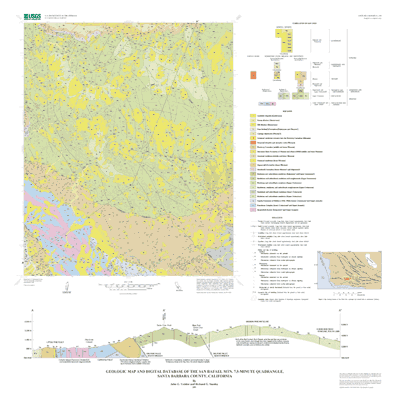
Geologic map and digital database of the San Rafael Mtn. 7.5-
minute Quadrangle, Santa Barbara County, California
Edition: 1.0
Geospatial_Data_Presentation_Form: geologic map
Series_Information:
Series_Name: U.S. Geological Survey Open-File Report
Issue_Identification: 01-290
Publication_Information:
Publication_Place: Menlo Park, CA
Publisher: U.S. Geological Survey
Online_Linkage: http://pubs.usgs.gov/of/2001/0290/
Description:
Abstract:
This digital map database, compiled from previously published
and unpublished data, and new mapping by the authors,
represents the general distribution of bedrock and surficial
deposits in the mapped area. Together with the accompanying
text file (srm_expl.txt, srm_expl.pdf), it provides current
information on the geologic structure and stratigraphy of the
area covered. The database delineates map units that are
identified by general age and lithology following the
stratigraphic nomenclature of the U.S. Geological Survey. The
scale of the source maps limits the spatial resolution (scale)
of the database to 1:24,000 or smaller.
Purpose:
This database and accompanying plot files depict the
distribution of geologic materials and structures at a
regional (1:24,000) scale. The report is intended to provide
geologic information for the regional study of materials
properties, earthquake shaking, landslide potential, mineral
hazards, mineral and energy resources, seismic velocity, and
earthquake faults. In addition, the report contains new
information and interpretations about the regional geologic
history and framework. However, the regional scale of this
report does not provide sufficient detail for site development
purposes. In addition, this map does not take the place of
fault-rupture hazard zones designated by the California State
Geologist (Hart and Bryant, 1997). Similarly, the database
cannot be substituted for comprehensive maps that
systematically identify and classify landslide hazards.
Supplemental_Information:
The databases in this report were compiled in ARC/INFO, a
commercial Geographic Information System (Environmental Systems
Research Institute, Redlands, California), with version 3.0 of
the menu interface ALACARTE (Fitzgibbon and Wentworth, 1991,
Fitzgibbon, 1991, Wentworth and Fitzgibbon, 1991). The files
are COVERAGE (ARC/INFO vector data) format. Coverages are
stored in uncompressed ARC export format (ARC/INFO version 8.0.
2). ARC/INFO export files (files with the .e00 extension) can
be converted into ARC/INFO coverages in ARC/INFO (see below)
and can be read by some other Geographic Information Systems,
such as MapInfo via ArcLink and ESRI's ArcView (version 1.0 for
Windows 3.1 to 3.11 is available for free from ESRI's web site:
http://www.esri.com). The digital compilation was done in
version 7.2.1 of ARC/INFO with version 3.0 of the menu
interface ALACARTE (Fitzgibbon and Wentworth, 1991, Fitzgibbon,
1991, Wentworth and Fitzgibbon, 1991). The geologic map
information was digitized from stable originals of the geologic
maps at 1:24,000 scale. The author manuscripts (pen on mylar)
were scanned using a Altek monochrome scanner with a resolution
of 800 dots per inch. The scanned images were vectorized and
transformed from scanner coordinates to projection coordinates
with digital tics placed by hand at quadrangle corners. The
scanned lines were edited interactively by hand using ALACARTE,
color boundaries were tagged as appropriate, and some scanning
artifacts visible at 1:24,000 were removed.
This report consists of a set of geologic map database files
(Arc/Info coverages) and supporting text and plotfiles. In
addition, the report includes two sets of plotfiles (PostScript
and PDF format) that will generate map sheets and pamphlets
similar to a traditional USGS Open-File Report. These files
are described in the explanatory pamphlets (srm.ps, srm.pdf,
and srm.txt). The base map layers used in the preparation of
the geologic map plotfiles were scanned from a scale-stable
version of the USGS 1:24,000 topographic maps of the San Rafael
Mtn. (1959, photorevised 1988) 7.5-minute quadrangle. The map
has a 40 foot contour interval.
Time_Period_of_Content:
Time_Period_Information:
Single_Date/Time:
Calendar_Date: 2001
Currentness_Reference:
The date given is the publication date. The information in the
report is the most up-to-date available at the time of
publication.
Status:
Progress: Complete
Maintenance_and_Update_Frequency: As needed
Spatial_Domain:
Bounding_Coordinates:
West_Bounding_Coordinate: -119.8749999
East_Bounding_Coordinate: -119.74990599
North_Bounding_Coordinate: 34.74999996
South_Bounding_Coordinate: 34.62498399
Keywords:
Theme:
Theme_Keyword_Thesaurus: USGS Thesaurus
Theme_Keyword: geology
Theme_Keyword: geologic maps
Theme_Keyword: bedrock geologic units
Theme_Keyword: surficial geologic units
Theme_Keyword: geologic history
Theme_Keyword: geologic structure
Theme_Keyword: geospatial datasets
Theme:
Theme_Keyword_Thesaurus: none
Theme_Keyword: Franciscan complex
Theme_Keyword: Big Pine fault
Theme_Keyword: Hildreth fault
Theme_Keyword: Little Pine fault
Theme_Keyword: Mission Pine anticline
Theme_Keyword: Hurricane Deck Syncline
Theme_Keyword: Camuesa fault
Theme_Keyword: geologic map
Theme_Keyword: digital database
Theme:
Theme_Keyword_Thesaurus: ISO 19115 Topic Categories
Theme_Keyword: geoscientificInformation
Place:
Place_Keyword_Thesaurus: none
Place_Keyword: United States of America
Place_Keyword: California
Place_Keyword: Santa Barbara County
Stratum:
Stratum_Keyword_Thesaurus: None
Stratum_Keyword: Landslide deposits
Stratum_Keyword: Young alluvium
Stratum_Keyword: Old alluvium
Stratum_Keyword: Paso Robles(?) Formation
Stratum_Keyword: Careaga Sandstone
Stratum_Keyword: Unnamed sandstone intrusive into the Monterey Formation
Stratum_Keyword: Unnamed intrusive and extrusive rocks
Stratum_Keyword: Monterey Formation
Stratum_Keyword: Hurricane Deck Formation of Thomas and others (1988)
Stratum_Keyword: Unnamed mudstone
Stratum_Keyword: Unnamed sandstone
Stratum_Keyword: Vaqueros(?) Formation
Stratum_Keyword: Simmler(?) Formation
Stratum_Keyword: Mudstone and subordinate sandstone
Stratum_Keyword: Sandstone and subordinate mudstone and conglomerate
Stratum_Keyword: Mudstone and subordinate sandstone
Stratum_Keyword: Sandstone, mudstone, and subordinate conglomerate
Stratum_Keyword: Sandstone and subordinate mudstone
Stratum_Keyword: Mudstone and subordinate sandstone
Stratum_Keyword: Espada Formation of Dibblee (1950, 1966)
Stratum_Keyword: Franciscan Complex
Stratum_Keyword: Serpentinite
Temporal:
Temporal_Keyword_Thesaurus: None
Temporal_Keyword: Mesozoic
Temporal_Keyword: Jurassic
Temporal_Keyword: Cretaceous
Temporal_Keyword: Cenozoic
Temporal_Keyword: Tertiary
Temporal_Keyword: Paleocene
Temporal_Keyword: Oligocene
Temporal_Keyword: Miocene
Temporal_Keyword: Pliocene
Temporal_Keyword: Quaternary
Temporal_Keyword: Pleistocene
Temporal_Keyword: Holocene
Place:
Place_Keyword_Thesaurus: Augmented FIPS 10-4 and FIPS 6-4
Place_Keyword: f06083 = Santa Barbara
Access_Constraints: None
Use_Constraints:
Uses of this digital geologic map should not violate the spatial
resolution of the data. Although the digital form of the data
removes the constraint imposed by the scale of a paper map, the
detail and accuracy inherent in map scale are also present in the
digital data. The fact that this database was edited for a scale
of 1:24,000 means that higher resolution information is not
present in the dataset. Plotting at scales larger than 1:24,000
will not yield greater real detail, although it may reveal fine-
scale irregularities below the intended resolution of the
database. Similarly, where this database is used in combination
with other data of higher resolution, the resolution of the
combined output will be limited by the lower resolution of these
data.
Point_of_Contact:
Contact_Information:
Contact_Organization_Primary:
Contact_Organization: USGS Western Earth Surface Processes Team
Contact_Person: Database coordinator
Contact_Address:
Address_Type: mailing address
Address: 345 Middlefield Road, MS 975
City: Menlo Park
State_or_Province: CA
Postal_Code: 94025
Country: USA
Browse_Graphic:
Data_Set_Credit:
Reconnaissance geologic mapping by H.E. Clifton, D.L. Durham, H.
D. Gower, and J.G. Vedder, April-May 1965. Selective geologic
mapping, including helicopter overflights, by Hugh McLean and J.
G. Vedder, September 1980; September 1981. Detailed geologic
mapping of Franciscan Complex by A.D. Wahl, 1990-1992. Detailed
geologic mapping by R.G. Stanley and J.G. Vedder, September 1996;
June, September, and October 1997. Detailed geologic mapping by
R.G. Stanley, June, September, and October 1998.
We thank the United States Department of Agriculture, U.S. Forest
Service, for facilitating access to remote parts of the Los
Padres National Forest, and the owners and employees of Rancho
San Fernando Rey for providing access to private lands. We also
thank R.E. Denison (University of Texas at Dallas) for providing
a strontium isotopic age on shell material from the unnamed
Miocene sandstone (unit Tss); Scott Graham, Zenon Valin, and Todd
Fitzgibbon (U.S. Geological Survey, Menlo Park) for assisting
with digital preparation of the map; Robert G. Bohannon (U.S.
Geological Survey, Menlo Park) and Scott A. Minor (U.S.
Geological Survey, Denver, CO) for technical reviews; and Paul
Stone (U.S. Geological Survey, Menlo Park) for suggestions that
improved the clarity of the map and accompanying materials.
Native_Data_Set_Environment: SunOS, 5.5.1, sun4u UNIX, ARC/INFO version 7.2.1