Geologic map of the Lakeview 7.5' quadrangle, Riverside County, California

Metadata also available as - [Questions & Answers] - [Parseable text] - [XML]

Metadata:

Identification_Information:
Citation:
Citation_Information:
Originator: D.M. Morton
Originator: J.C. Matti
Publication_Date: 2001
Title:
Geologic map of the Lakeview 7.5' quadrangle, Riverside County, California
Edition: Version 1.0
Geospatial_Data_Presentation_Form: vector digital data
Series_Information:
Series_Name: U.S. Geological Survey Open-File Report
Issue_Identification: 01-174
Publication_Information:
Publication_Place: Menlo Park, California
Publisher: U.S. Geological Survey
Online_Linkage: http://pubs.usgs.gov/of/2001/0174/
Description:
Abstract:
This data set maps and describes the geology of the Lakeview 7.5' quadrangle, Riverside County, California. The quadrangle encompasses part of the northern Peninsular Ranges Province. Tonalitic granitic rocks of the Cretaceous Peninsular Range batholith dominate the bedrock areas, and include rocks ranging in composition from monzogranite to gabbro. The Lakeview Mountains are underlain chiefly by tonalite of the Lakeview pluton and related rocks. In the northeastern corner of the quadrangle, Tertiary sedimentary rocks of the San Timoteo beds of Frick (1921) and Mount Eden Formation of Fraser (1931) rest on Paleozoic schist, quartzite, gneiss, and marble having a well developed east dipping foliation. The Tertiary formations are much more extensively exposed in the San Timoteo Badlands to the northeast and southeast. These Tertiary and Paleozoic units are separated from the Lakeview Mountains by the San Jacinto Valley, which locally contains up to 3,000 m of Quaternary sediments. Two strands of the seismically active San Jacinto Fault zone bound the Valley, the Claremont Fault on the northeast side, and the Casa Loma Fault on the southwest side. Numerous cracks and fissures related to both groundwater withdrawal and tectonic movements are developed in the Quaternary sediments, especially in the northern part of the quadrangle.
Created using Environmental Systems Research Institute's ARC/INFO software, the database consists of the following items: (1) a map coverage containing faults, geologic contacts and units, (2) a coverage showing structural data, (3) a coverage containing geologic unit annotation and leaders, and (4) five additional INFO data tables (.rel) that contain detailed, coded, geologic information such as texture, fabric, color, and mineralogy and (5) line and point dictionaries, lines.rel and points.rel. These additional data are accessible to the user through the utilization of ARC/INFO relate environments and provide the user access to as much or as little of the encoded data as required. In addition, the data set includes the following graphic and text products: (1) A PostScript graphic plot-file containing the geologic map, topography, cultural data, a Correlation of Map Units (CMU) diagram, a Description of Map Units (DMU), and a key for point and line symbols, and (2) PDF files of this Readme (including the metadata file as an appendix), the poly_attrib_code.txt (the polygon attribute coding), and the graphic produced by the Postscript plot file.
The geologic map database contains original U.S. Geological Survey data generated by detailed field observation and by interpretation of aerial photographs. Within the database, geologic contacts are represented as lines (arcs), geologic units as polygons, and site-specific data as points. Polygon, arc, and point attribute tables (.pat, .aat, and .pat, respectively) uniquely identify each geologic datum.
Purpose:
The data set for the Lakeview quadrangle has been prepared by the Southern California Areal Mapping Project (SCAMP), a cooperative project sponsored jointly by the U.S. Geological Survey and the California Division of Mines and Geology. The Lakeview data set represents part of an ongoing effort to create a regional GIS geologic database for southern California. This regional digital database, in turn, is being developed as a contribution to the National Geologic Map Database of the National Cooperative Geologic Mapping Program of the USGS.
The digital geologic map database for the Lakeview 7.5' quadrangle has been created as a general-purpose data set that is applicable to other land-related investigations in the earth and biological sciences. For example, it can be used for groundwater studies in the San Bernardino basin, and for mineral resource evaluation studies, animal and plant habitat studies, and soil studies in the San Bernardino National Forest. The database is not suitable for site-specific geologic evaluations.
Supplemental_Information:
Within the geologic map database, map units are identified by standard geologic map criteria such as formation-name, age, and lithology. The authors have attempted to adhere to the stratigraphic nomenclature of the U.S. Geological Survey and the North American Stratigraphic Code, but the database has not received a formal editorial review of geologic names.
Geologic map unit labels entered in database items LABL and PLABL contain substitute characters for conventional stratigraphic age symbols: Paleozoic appears as 'Pz' in LABL and as '|' in PLABL. The substitute characters in PLABL invoke their corresponding symbols from the GeoAge font group to generate map unit labels with conventional stratigraphic symbols.
Time_Period_of_Content:
Time_Period_Information:
Range_of_Dates/Times:
Beginning_Date: 19620401
Ending_Date: 20000201
Currentness_Reference: New data
Status:
Progress: Complete
Maintenance_and_Update_Frequency: As needed
Spatial_Domain:
Bounding_Coordinates:
West_Bounding_Coordinate: -117.12509085
East_Bounding_Coordinate: -116.99990904
North_Bounding_Coordinate: 33.87499933
South_Bounding_Coordinate: 33.74998308
Keywords:
Theme:
Theme_Keyword_Thesaurus: USGS Thesaurus
Theme_Keyword: geology
Theme_Keyword: geologic maps
Theme_Keyword: bedrock geologic units
Theme_Keyword: geologic structure
Theme_Keyword: geospatial datasets
Theme:
Theme_Keyword_Thesaurus: none
Theme_Keyword: Active fault
Theme_Keyword: San Jacinto Fault
Theme_Keyword: surficial geology
Theme:
Theme_Keyword_Thesaurus: ISO 19115 Topic Categories
Theme_Keyword: geoscientificInformation
Place:
Place_Keyword_Thesaurus: none
Place_Keyword: California
Place_Keyword: Riverside County
Place_Keyword: Lakeview 7.5' quadrangle
Place_Keyword: Peninsular Ranges
Stratum:
Stratum_Keyword_Thesaurus: None
Stratum_Keyword: Peninsular Ranges batholith
Stratum_Keyword: Granitic rocks
Stratum_Keyword: Tonalite
Place:
Place_Keyword_Thesaurus: Augmented FIPS 10-4 and FIPS 6-4
Place_Keyword: f06065 = Riverside
Access_Constraints: None
Use_Constraints:
The Lakeview 7.5' geologic-map database should be used to evaluate and understand the geologic character of the Lakeview 7.5' quadrangle as a whole. The data should not be used for purposes of site-specific land-use planning or site-specific geologic evaluations. The database is sufficiently detailed to identify and characterize geologic materials and structures. However, it is not sufficiently detailed for site-specific determinations.
Use of this digital geologic map database should not violate the spatial resolution of the data. Although the digital form of the data removes the constraint imposed by the scale of a paper map, the detail and accuracy inherent in map scale are also present in the digital data. The fact that this database was compiled and edited at a scale of 1:24,000 means that higher resolution information may not have been uniformly retained in the dataset. Plotting at scales larger than 1:24,000 will not yield greater real detail, although it may reveal fine-scale irregularities below the intended resolution of the database. Similarly, although higher resolution data is incorporated in parts of the map, the resolution of the combined output will be limited by the lower resolution data.
Point_of_Contact:
Contact_Information:
Contact_Person_Primary:
Contact_Person: D.M. Morton
Contact_Organization:
U.S. Geological Survey, Western Region, Earth Surface Processes Team
Contact_Position: Project chief
Contact_Address:
Address_Type: mailing address
Address:
U.S. Geological Survey
Department of Geology
University of California, Riverside
City: Riverside
State_or_Province: California
Postal_Code: 92521
Country: United States of America
Contact_Voice_Telephone: (909) 276-6397
Contact_Facsimile_Telephone: (909) 276-6295
Contact_Electronic_Mail_Address: scamp@usgs.gov
Browse_Graphic:
Browse_Graphic_File_Name: http://pubs.usgs.gov/of/2001/0174/images/coverthb.gif
Browse_Graphic_File_Description:
Simple image of the geologic map, topographic base, Correlation of Map Units, a description of Map Units and key to point and line symbols
Browse_Graphic_File_Type: GIF
Browse_Graphic:
Browse_Graphic_File_Name: http://pubs.usgs.gov/of/2001/0174/pdf/lkvw_map.pdf
Browse_Graphic_File_Description:
Navigable portable document file (.pdf) image of the geologic map, topographic base, Correlation of Map Units, Description of Map Units and key to point and line symbols.
Browse_Graphic_File_Type: PDF
Data_Set_Credit:
Technical review by M. Dawson and F. Miller led to significant improvements that eventually were reflected in aspects of the database, the plot file, and in the description of the geologic units of the Lakeview 7.5' quadrangle. Digital review by R.W. Graymer has allowed us to prepare a much improved product.
Geologic mapping and digital preparation of this report were sponsored jointly by (1) the National Cooperative Geologic Mapping Program of the U.S. Geological Survey, (2) the California Division of Mines and Geology, and (3) the Southern California Areal Mapping Project (SCAMP). The digital preparation of the data set was carried out by Rachel Alvarez and Gary Patt at the SCAMP Geographic Information System laboratory in Riverside, and by Pamela M. Cossette at the USGS Mineral Resources Program GIS lab in Spokane, Washington.
Native_Data_Set_Environment: SunOS, 5.6, sun4u UNIX ARC/INFO version 7.2.1
Cross_Reference:
Citation_Information:
Originator: D.M. Morton
Publication_Date: 1972
Title:
Geology of the Lakeview-Perris quadrangles, Riverside County, California
Geospatial_Data_Presentation_Form: paper map
Series_Information:
Series_Name: California Division of Mines and Geology Map
Issue_Identification: Map Sheet 19
Publication_Information:
Publication_Place: Sacramento, California
Publisher: California Division of Mines and Geology
Data_Quality_Information:
Attribute_Accuracy:
Attribute_Accuracy_Report:
Geologic-map units in the Lakeview quadrangle database were described using standard field methods. Consistent with these methods, the database author has assigned standard geologic attributes to geologic lines, points, and polygons identified in the database.
Nation-wide geologic-map accuracy standards have not been developed and adopted by the U.S. Geological Survey and other earth-science entities. Until such standards are adopted, the SCAMP project has developed internal map-accuracy standards for 1:24,000-scale geologic maps produced by the project.
Geologic lines and points on 1:24,000 scale geologic maps are judged to meet SCAMP's internal map-accuracy standards if they are located to within +/-15 meters, relative to topographic or cultural features on the base map.
Lines and points that meet (or may not meet) this SCAMP internal map-accuracy standard are identified both in the digital database and on derivative geologic-map plots. Within the database, line and point data that are judged to meet the SCAMP internal map-accuracy standard are denoted by the attribute code .MEE. (meets) in the appropriate data table; line and point data that may not meet the SCAMP internal map-accuracy standard are denoted by the attribute code .MNM. (may not meet).
On any derivative geologic-map plot, line data that are judged to meet the SCAMP internal map-accuracy standard are denoted by solid lines; line data that may not meet the SCAMP internal map-accuracy standard are denoted by dashed or dotted lines. There is no cartographic device for denoting the map-accuracy for geologic-point data (eg. symbols representing bedding, foliation, lineations, etc.).
Logical_Consistency_Report:
Polygon and chain-node topology present.
The areal extent of the map is represented digitally by an appropriately projected (Polyconic projection), mathematically generated box. Consequently, polygons intersecting the lines that comprise the map boundary are closed by that boundary. Polygons internal to the map boundary are completely enclosed by line segments which are themselves a set of sequentially numbered coordinate pairs. Point data are represented by coordinate pairs.
Completeness_Report:
The geologic map and digital database of the Lakeview 7.5' quadrangle contain new data that have been subjected to rigorous review and are a substantially complete representation of the current state of knowledge concerning the geology of the quadrangle.
Positional_Accuracy:
Horizontal_Positional_Accuracy:
Horizontal_Positional_Accuracy_Report:
The maximum transformation RMS error acceptable for 7.5' quadrangle transformation and data input is 0.003 (7.6 meters). Horizontal positional accuracy was checked by visual comparison of hard-copy plots with base-stable source data.
Lineage:
Process_Step:
Process_Description:
Field mapping and aerial photograph interpretation; iterative process (D.M. Morton and J.C. Matti).
Process_Date: 1962-1963 and 1980
Process_Step:
Process_Description:
Transfer of geologic linework and point data from field maps and aerial photographs to a scale-stable cartographic base of quadrangle (scribeguide) (D.M. Morton and J.C. Matti).
Process_Date: 1964 and 1981
Process_Step:
Process_Description:
Description of Map Units and Correlation of Map Units (D.M. Morton and J.C. Matti)
Process_Date: 1964, 1981, and 1998
Process_Step:
Process_Description:
The geologic map information was hand digitized from author-prepared base-stable geologic map at 1:24,000 scale. (Rachel Alvarez and Gary Patt). Preliminary ARC/INFO database established.
Process_Date: 1994
Process_Step:
Process_Description:
Detailed ARC/INFO database established; cleanup of ditizing artifacts; polygon, arc, and point attribute tables established using model developed for SCAMP coverages. Digitizing and editing artifacts significant enough to display at a scale of 1:24,000 were corrected (P.M. Cossette).
Process_Date: 1999
Process_Step:
Process_Description:
Polygons coded with detailed geologic information using model developed for SCAMP coverages. (D.M. Morton and F.K. Miller).
Process_Date: 1999
Process_Step:
Process_Description:
First draft of metadata created by cossette using FGDCMETA.AML ver. 1.2 05/14/98 on ARC/INFO data set /pool5/c/cossette2/lakeview/lkv-nonof/lkvw_geo
Process_Date: 20010320
Process_Step:
Process_Description: Creation of original metadata record
Process_Date: 20010711
Process_Contact:
Contact_Information:
Contact_Organization_Primary:
Contact_Organization: U.S. Geological Survey
Contact_Person: Pamela M. Cossette
Contact_Position: Cartographer
Contact_Address:
Address_Type: mailing
Address: 904 West Riverside Avenue, Rm. 202
City: Spokane
State_or_Province: WA
Postal_Code: 99201-1087
Country: USA
Contact_Voice_Telephone: (509) 368-3123
Contact_Facsimile_Telephone: (509) 368-3199
Contact_Electronic_Mail_Address: pcossette@usgs.gov
Spatial_Data_Organization_Information:
Direct_Spatial_Reference_Method: Vector
Point_and_Vector_Object_Information:
SDTS_Terms_Description:
SDTS_Point_and_Vector_Object_Type: Point
Point_and_Vector_Object_Count: 378
SDTS_Terms_Description:
SDTS_Point_and_Vector_Object_Type: String
Point_and_Vector_Object_Count: 1083
SDTS_Terms_Description:
SDTS_Point_and_Vector_Object_Type: GT-polygon composed of chains
Point_and_Vector_Object_Count: 379
Spatial_Reference_Information:
Horizontal_Coordinate_System_Definition:
Planar:
Map_Projection:
Map_Projection_Name: Polyconic
Polyconic:
Longitude_of_Central_Meridian: -117.0625
Latitude_of_Projection_Origin: 33.7500
False_Easting: 0.00000
False_Northing: 0.00000
Planar_Coordinate_Information:
Planar_Coordinate_Encoding_Method: coordinate pair
Coordinate_Representation:
Abscissa_Resolution: 0.000001
Ordinate_Resolution: 0.000001
Planar_Distance_Units: Meters
Geodetic_Model:
Horizontal_Datum_Name: North American Datum of 1927
Ellipsoid_Name: Clarke 1866
Semi-major_Axis: 6378206.4
Denominator_of_Flattening_Ratio: 294.98
Entity_and_Attribute_Information:
Overview_Description:
Entity_and_Attribute_Overview:
Version 1.0 of the Lakeview 7.5' quadrangle comprises three ARC/INFO coverages, of which two contain geologic data and one contains cartographic features: lkvw_geo (geology), lkvw_pts (structural point data), and lkvw_anno (geologic unit annotation and leaders). Geospatial entities in ARC/INFO coverages have the following software-defined attributes: <cover>.pat contains AREA, PERIMETER, cover#, and cover-ID; <cover>.aat contains FNODE#, TNODE#, LPOLY#, RPOLY#, LENGTH, cover#, and cover-ID. User-defined attributes are described in detail below.Two INFO tables, lines.rel and points.rel provide a full description of each of the geologic line and point features in the database. Full source citations are provided in the Entity_and Attribute_Detail_Citation section of this metadata document.
1) The coverage lkvw_geo includes a polygon feature attribute table (lkvw_geo.pat) that describes the geospatial distribution of rock units represented in the Postscript (.ps) and Portable Document Format (.pdf) plotfiles of the geologic maps and an arc feature attribute table (lkvw_geo.aat) that describes the contacts and faults that bound rock-unit polygons. Line and point identity data are recorded in the .aat and .pat using a system of identity codes. Two INFO tables, lines.rel and points.rel, provide a full description of each of the geological line and point codes in the database. For display purposes in the .ps and .pdf geologic maps, the geology coverage includes one annotation subclass: anno.fault, which contains formal fault names. In addition, the item TAG allows the user to access (relate to) a series of INFO data tables that contain additional, detailed, coded geologic data. A complete description of the polygon, line, and point data coding schemes is available in U.S. Geological Survey Open-File Reports 97-859, OFR 97-860, and OFR 97-861 (full source citations follow).
Five INFO data tables are included in the Lakeview database: lakeview_genesis.rel provides data summarizing the genesis of each of the major rock types that occur within a particular map rock unit, lakeview_summary.rel provides general information about a rock unit, lakeview_lithology.rel contains lithologic attributes for the main and secondary lithologic types in the geologic-map unit, lakeview_protolith.rel describes rock type protoliths, and lakeview_structure.rel contains geologic structural data. The tables have identical architecture. The item TAG serves as the relate item and there are five additional feature attribute items, LITH1...LITH5, that represent the major rock types within a rock unit. Lakeview_structure.rel contains an item STRHIST that contains attributes that describe the structural history of a particular unit.
2) The coverage lkvw_pts includes a point attribute table (lkvw_pts.pat) that describes both the types and orientation of bedding, foliation, and lineation. An annotation subclass displays the dip or plunge values associated with the point data.
3) The coverage lkvw_anno includes an arc attribute table (lkvw_ldr.pat) that describes annotation leaders and one annotation subclass, anno.geo, which contains unit labels derived from PLABL. Unit symbols that are placed outside the perimeter of a particular polygon identify that polygon with annotation leaders.
Entity_and_Attribute_Detail_Citation:
A complete description of the polygon, line, and point data coding schemes is available in the following U.S. Geological Survey Open-File Reports:
Matti, J.C., Miller, F.K., Powell, R.E., Kennedy, S.A., Bunyapanasarn, T.P., Koukladas, Catherine, Hauser, R.M., and Cossette, P.M., 1997b, Geologic-point attributes for digital geologic-map databases produced by the Southern California Areal Mapping Project (SCAMP), Version 1.0: U.S.Geological Survey Open-File Report 97-859
Matti, J.C., Miller, F.K., Powell, R.E., Kennedy, S.A., and Cossette, P.M., 1997c, Geologic-polygon attributes for digital geologic-map databases produced by the Southern California Areal Mapping Project (SCAMP), Version 1.0: U.S.Geological Survey Open-File Report 97-860
Matti, J.C., Powell, R.E., Miller, F.K., Kennedy, S.A., Ruppert, K.R., Morton, G.L., and Cossette, P.M., 1997a, Geologic-line attributes for digital geologic-map databases produced by the Southern California Areal Mapping Project (SCAMP), Version 1.0: U.S.Geological Survey Open-File Report 97-861
Detailed_Description:
Entity_Type:
Entity_Type_Label: LKVW_GEO.PAT
Entity_Type_Definition: Geologic map units
Attribute:
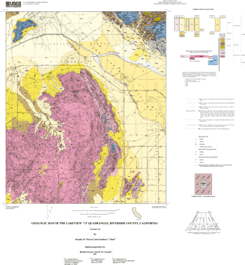
Attribute_Label: LABL
Attribute_Definition:
Geologic map unit label. Plain text is substituted for conventional geologic age symbols (Pz for Paleozoic) and unit label subscripts as annotated on map
Attribute_Domain_Values:
Enumerated_Domain:
Enumerated_Domain_Value: Qw
Enumerated_Domain_Value_Definition: Very young wash deposits, arenaceous
Attribute_Domain_Values:
Enumerated_Domain:
Enumerated_Domain_Value: Qyw
Enumerated_Domain_Value_Definition: Young wash deposits, arenaceous
Attribute_Domain_Values:
Enumerated_Domain:
Enumerated_Domain_Value: Qf
Enumerated_Domain_Value_Definition: Very young alluvial-fan deposits, arenaceous
Attribute_Domain_Values:
Enumerated_Domain:
Enumerated_Domain_Value: Qv
Enumerated_Domain_Value_Definition: Very young alluvial-valley deposits, siltey, clayey
Attribute_Domain_Values:
Enumerated_Domain:
Enumerated_Domain_Value: Qc
Enumerated_Domain_Value_Definition: Very young colluvial deposits
Attribute_Domain_Values:
Enumerated_Domain:
Enumerated_Domain_Value: Qlv
Enumerated_Domain_Value_Definition: Very young lacustrine and fluvial deposits, clayey, silty
Attribute_Domain_Values:
Enumerated_Domain:
Enumerated_Domain_Value: Qyf
Enumerated_Domain_Value_Definition: Young alluvial-fan deposits, arenaceous
Attribute_Domain_Values:
Enumerated_Domain:
Enumerated_Domain_Value: Qyf
Enumerated_Domain_Value_Definition: Young alluvial-fan deposits, gravel, arenaceous
Attribute_Domain_Values:
Enumerated_Domain:
Enumerated_Domain_Value: Qyf6
Enumerated_Domain_Value_Definition: Young alluvial-fan deposits, Unit 6, gravel, arenaceous
Attribute_Domain_Values:
Enumerated_Domain:
Enumerated_Domain_Value: Qyf5
Enumerated_Domain_Value_Definition: Young alluvial-fan deposits, Unit 5, gravel, arenaceous
Attribute_Domain_Values:
Enumerated_Domain:
Enumerated_Domain_Value: Qyf4
Enumerated_Domain_Value_Definition: Young alluvial-fan deposits, Unit 4, gravel, arenaceous
Attribute_Domain_Values:
Enumerated_Domain:
Enumerated_Domain_Value: Qyf3
Enumerated_Domain_Value_Definition: Young alluvial-fan deposits, Unit 3, gravel, arenaceous
Attribute_Domain_Values:
Enumerated_Domain:
Enumerated_Domain_Value: Qyf2
Enumerated_Domain_Value_Definition: Young alluvial-fan deposits, Unit 2, gravel, arenaceous
Attribute_Domain_Values:
Enumerated_Domain:
Enumerated_Domain_Value: Qyf1
Enumerated_Domain_Value_Definition: Young deposits of alluvial fans, Unit 1, gravel, arenaceous
Attribute_Domain_Values:
Enumerated_Domain:
Enumerated_Domain_Value: Qya
Enumerated_Domain_Value_Definition: Young axial-valley floor deposits, arenaceous
Attribute_Domain_Values:
Enumerated_Domain:
Enumerated_Domain_Value: Qyv
Enumerated_Domain_Value_Definition: Young alluvial-valley deposits, arenaceous
Attribute_Domain_Values:
Enumerated_Domain:
Enumerated_Domain_Value: Qyv
Enumerated_Domain_Value_Definition: Young alluvial-valley deposits, clayey, arenaceous
Attribute_Domain_Values:
Enumerated_Domain:
Enumerated_Domain_Value: Qyv
Enumerated_Domain_Value_Definition: Young alluvial-valley deposits, clayey, silty
Attribute_Domain_Values:
Enumerated_Domain:
Enumerated_Domain_Value: Qyv
Enumerated_Domain_Value_Definition: Young alluvial-valley deposits, silty, arenaceous
Attribute_Domain_Values:
Enumerated_Domain:
Enumerated_Domain_Value: Qyv
Enumerated_Domain_Value_Definition: Young alluvial-valley deposits, silty, clayey
Attribute_Domain_Values:
Enumerated_Domain:
Enumerated_Domain_Value: Qyv1
Enumerated_Domain_Value_Definition: Young alluvial-valley deposits, Unit 1, arenaceous
Attribute_Domain_Values:
Enumerated_Domain:
Enumerated_Domain_Value: Qyls
Enumerated_Domain_Value_Definition: Young landslide deposits
Attribute_Domain_Values:
Enumerated_Domain:
Enumerated_Domain_Value: Qof
Enumerated_Domain_Value_Definition: Old alluvial-fan deposits, arenaceous
Attribute_Domain_Values:
Enumerated_Domain:
Enumerated_Domain_Value: Qofv
Enumerated_Domain_Value_Definition:
Old alluvial-fan deposits and very young alluvial-valley deposits, arenaceous
Attribute_Domain_Values:
Enumerated_Domain:
Enumerated_Domain_Value: Qov
Enumerated_Domain_Value_Definition: Old alluvial-valley deposits
Attribute_Domain_Values:
Enumerated_Domain:
Enumerated_Domain_Value: Qoc
Enumerated_Domain_Value_Definition: Old colluvial deposits
Attribute_Domain_Values:
Enumerated_Domain:
Enumerated_Domain_Value: Qoc
Enumerated_Domain_Value_Definition: Old colluvial deposits, gravel
Attribute_Domain_Values:
Enumerated_Domain:
Enumerated_Domain_Value: Qvof
Enumerated_Domain_Value_Definition: Very old alluvial-fan deposits, arenaceous
Attribute_Domain_Values:
Enumerated_Domain:
Enumerated_Domain_Value: Qvof
Enumerated_Domain_Value_Definition: Very old alluvial-fan deposits, gravel
Attribute_Domain_Values:
Enumerated_Domain:
Enumerated_Domain_Value: Qvov
Enumerated_Domain_Value_Definition: Very old alluvial-valley deposits, arenaceous
Attribute_Domain_Values:
Enumerated_Domain:
Enumerated_Domain_Value: Tstl
Enumerated_Domain_Value_Definition: San Timoteo beds of Frick (1921)
Attribute_Domain_Values:
Enumerated_Domain:
Enumerated_Domain_Value: Tmeus
Enumerated_Domain_Value_Definition: Mount Eden Formation of Fraser (1931), upper sandstone member
Attribute_Domain_Values:
Enumerated_Domain:
Enumerated_Domain_Value: Tmels
Enumerated_Domain_Value_Definition: Mount Eden Formation of Fraser (1931), lower sandstone member
Attribute_Domain_Values:
Enumerated_Domain:
Enumerated_Domain_Value: Tmea
Enumerated_Domain_Value_Definition: Mount Eden Formation of Fraser (1931), arkosic sandstone member
Attribute_Domain_Values:
Enumerated_Domain:
Enumerated_Domain_Value: Tmeb
Enumerated_Domain_Value_Definition: Mount Eden Formation of Fraser (1931), boulder breccia lenses
Attribute_Domain_Values:
Enumerated_Domain:
Enumerated_Domain_Value: Tmec
Enumerated_Domain_Value_Definition:
Mount Eden Formation of Fraser (1931), conglomeratic sandstone member
Attribute_Domain_Values:
Enumerated_Domain:
Enumerated_Domain_Value: Kmeg
Enumerated_Domain_Value_Definition: Granite of Mount Eden
Attribute_Domain_Values:
Enumerated_Domain:
Enumerated_Domain_Value: Klt
Enumerated_Domain_Value_Definition: Tonalite of Laborde Canyon
Attribute_Domain_Values:
Enumerated_Domain:
Enumerated_Domain_Value: Ktcg
Enumerated_Domain_Value_Definition: Monzogranite of Tres Cerritos
Attribute_Domain_Values:
Enumerated_Domain:
Enumerated_Domain_Value: Kp
Enumerated_Domain_Value_Definition: Lakeview Mountains pluton, pegmatite dikes
Attribute_Domain_Values:
Enumerated_Domain:
Enumerated_Domain_Value: Klmt
Enumerated_Domain_Value_Definition: Lakeview Mountains pluton, tonalite
Attribute_Domain_Values:
Enumerated_Domain:
Enumerated_Domain_Value: Klml
Enumerated_Domain_Value_Definition: Lakeview Mountains pluton, leucocratic tonalite
Attribute_Domain_Values:
Enumerated_Domain:
Enumerated_Domain_Value: Klmm
Enumerated_Domain_Value_Definition: Lakeview Mountains pluton, melanocratic tonalite
Attribute_Domain_Values:
Enumerated_Domain:
Enumerated_Domain_Value: Klmg
Enumerated_Domain_Value_Definition: Lakeview Mountains pluton, hypersthene-hornblende gabbro
Attribute_Domain_Values:
Enumerated_Domain:
Enumerated_Domain_Value: Khg
Enumerated_Domain_Value_Definition: Heterogeneous granitic rocks
Attribute_Domain_Values:
Enumerated_Domain:
Enumerated_Domain_Value: Krct
Enumerated_Domain_Value_Definition: Reinhardt Canyon pluton
Attribute_Domain_Values:
Enumerated_Domain:
Enumerated_Domain_Value: KgPz
Enumerated_Domain_Value_Definition: Mixed metamorphic rocks and granitic rocks
Attribute_Domain_Values:
Enumerated_Domain:
Enumerated_Domain_Value: Pzu
Enumerated_Domain_Value_Definition: Metamorphic rocks, undivided
Attribute_Domain_Values:
Enumerated_Domain:
Enumerated_Domain_Value: m
Enumerated_Domain_Value_Definition: Marble
Attribute:
Attribute_Label: PLABL
Attribute_Definition:
Coded geologic map unit label used to generate plot label. Subscripted characters indicate lithologies within the overall unit.
Attribute:
Attribute_Label: SHDPS
Attribute_Definition:
Coded integer that relates polygon to color in shadeset scamp2.shd
Attribute:
Attribute_Label: SHDFIL
Attribute_Definition:
Coded integer that relates polygon to fill pattern in shadeset geology2.shd
Attribute:
Attribute_Label: NAME
Attribute_Definition: Geologic name of map unit (see list under LABL attribute)
Attribute:
Attribute_Label: TAG
Attribute_Definition:
A reference label for subgroups of polygons of the geologic-map unit identified by LABL. Each polygon subgroup has certain attributes in common with all other polygons of the map unit. However, each subgroup may have unique, distinguishing attributes which warrant recognition in the database although those distinguishing characteristics do not warrant recognition as new map units.
TAG is defined as LABL followed by an upper-case letter, e.g., QwA, QwB, or QwC, etc. Map units in the Lakeview quadrangle are assigned an A tag designation except for Qyv (QyvA, QyvB and QyvC) and Qyf (QyfA, QyfB and QyfC).
TAG serves one additional purpose: it functions as the relate item that associates each polygon with its attributes stored in the five polygon-attribute data tables identified in the overview description.
Detailed_Description:
Entity_Type:
Entity_Type_Label: LKVW_GEO.AAT
Entity_Type_Definition: Geologic contacts and faults that bound rock-unit polygons
Attribute:
Attribute_Label: L-SYMB
Attribute_Definition:
Coded integer symbol that relates arc to cartographic line symbol in lineset geoscamp2.lin
Attribute:
Attribute_Label: L-TAG
Attribute_Definition:
Coded alpha-numerical symbol that relates arc to definition of line type in dictionary look-up table (lines.rel). For description of attributes in line classification dictionary, refer to USGS Open-File Report 97-861 (see Entity_and_Attribute_Detail_Citation)
Attribute_Domain_Values:
Enumerated_Domain:
Enumerated_Domain_Value: C17
Enumerated_Domain_Value_Definition: Contact, landslide, location meets map accuracy standard
Attribute_Domain_Values:
Enumerated_Domain:
Enumerated_Domain_Value: C29
Enumerated_Domain_Value_Definition: Contact, sedimentary, location meets map accuracy standard
Attribute_Domain_Values:
Enumerated_Domain:
Enumerated_Domain_Value: C30
Enumerated_Domain_Value_Definition:
Contact, sedimentary, location may not meet map accuracy standard
Attribute_Domain_Values:
Enumerated_Domain:
Enumerated_Domain_Value: C31
Enumerated_Domain_Value_Definition:
Contact, sedimentary, inferred, location may not meet map accuracy standard
Attribute_Domain_Values:
Enumerated_Domain:
Enumerated_Domain_Value: C37
Enumerated_Domain_Value_Definition:
Contact, separates terraced alluvial units, location meets map accuracy standard
Attribute_Domain_Values:
Enumerated_Domain:
Enumerated_Domain_Value: C41
Enumerated_Domain_Value_Definition:
Contact, sedimentary, gradational, location may not meet map accuracy standard
Attribute_Domain_Values:
Enumerated_Domain:
Enumerated_Domain_Value: C49
Enumerated_Domain_Value_Definition: Contact, igneous, location meets map accuracy standard
Attribute_Domain_Values:
Enumerated_Domain:
Enumerated_Domain_Value: C50
Enumerated_Domain_Value_Definition: Contact, igneous, location may not meet map accuracy standard
Attribute_Domain_Values:
Enumerated_Domain:
Enumerated_Domain_Value: C65
Enumerated_Domain_Value_Definition: Contact, metamorphic, location meets map accuracy standard
Attribute_Domain_Values:
Enumerated_Domain:
Enumerated_Domain_Value: CL1
Enumerated_Domain_Value_Definition: Cartographic line, map boundary
Attribute_Domain_Values:
Enumerated_Domain:
Enumerated_Domain_Value: DK9
Enumerated_Domain_Value_Definition: Dike, location may not meet map accuracy standard
Attribute_Domain_Values:
Enumerated_Domain:
Enumerated_Domain_Value: F6
Enumerated_Domain_Value_Definition:
Fault, high-angle, oblique slip, location meets map accuracy standard
Attribute_Domain_Values:
Enumerated_Domain:
Enumerated_Domain_Value: F12
Enumerated_Domain_Value_Definition:
Fault, high-angle, oblique slip, location may not meet map accuracy standard
Attribute_Domain_Values:
Enumerated_Domain:
Enumerated_Domain_Value: F18
Enumerated_Domain_Value_Definition:
Fault, high-angle, oblique slip, inferred, location may not meet map accuracy standard
Attribute_Domain_Values:
Enumerated_Domain:
Enumerated_Domain_Value: F24
Enumerated_Domain_Value_Definition:
Fault, high-angle, oblique slip, lnferred beneath mapped covering unit
Attribute_Domain_Values:
Enumerated_Domain:
Enumerated_Domain_Value: F36
Enumerated_Domain_Value_Definition:
Fault, high-angle, oblique slip, existence questionable, location may not meet map accuracy standard
Attribute_Domain_Values:
Enumerated_Domain:
Enumerated_Domain_Value: F54
Enumerated_Domain_Value_Definition:
Fault, high-angle, oblique slip, scarp, location meets map accuracy standard
Attribute_Domain_Values:
Enumerated_Domain:
Enumerated_Domain_Value: GF9
Enumerated_Domain_Value_Definition:
Geomorphic feature.ground-failure scarp.certain.may not meet map accuracy standard
Attribute:
Attribute_Definition:
The features tagged GF9 in this report are scarps caused by groundwater withdrawal.
Attribute_Domain_Values:
Enumerated_Domain:
Enumerated_Domain_Value: ML8
Enumerated_Domain_Value_Definition:
fissure.due to groundwater withdrawal and/or tectonics.certain.may not meet map accuracy standard
Enumerated_Domain_Value_Definition_Source:
The miscellaneous linetype, ML8, has been added to lines.rel (included in the data package) but does not appear in the corresponding source USGS Open-file Report: Matti, J.C., Powell, R.E., Miller, F.K., Kennedy, S.A., Ruppert, K.R., Morton, G.L., and Cossette, P.M., 1997a, Geologic-line attributes for digital geologic-map databases produced by the Southern California Areal Mapping Project (SCAMP), Version 1.0: U.S.Geological Survey Open-File Report 97-861
Attribute:
Attribute_Definition:
Features tagged ML8 in this report are ground fissures caused by a combination of tectonic movements on faults of the San Jacinto Fault zone and groundwater withdrawal.
Attribute:
Attribute_Label: L-NAME
Attribute_Definition: Formal name of linear geologic feature
Detailed_Description:
Entity_Type:
Entity_Type_Label: LKVW_PTS.PAT
Entity_Type_Definition: Structural point data
Attribute:
Attribute_Label: P-DIP
Attribute_Definition: Dip of planar feature
Attribute:
Attribute_Label: P-STRIKE
Attribute_Definition: Azimuthal strike of planar feature
Attribute:
Attribute_Label: P-SYMB
Attribute_Definition:
Coded integer symbol that relates point to cartographic point symbol in markerset (geoscamp2.mrk)
Attribute:
Attribute_Label: P-TAG
Attribute_Definition:
Coded alpha-numerical symbol that relates point to definition of point type in dictionary look-up table (points.rel). For description of attributes in point classification dictionary, refer to USGS Open-File Report 97-859 (see Entity_and_Attribute_Detail_Citation)
Attribute_Domain_Values:
Enumerated_Domain:
Enumerated_Domain_Value: B1
Enumerated_Domain_Value_Definition: Bedding attitude, sedimentary, horizontal
Attribute_Domain_Values:
Enumerated_Domain:
Enumerated_Domain_Value: B2
Enumerated_Domain_Value_Definition: Bedding attitude, sedimentary, inclined
Attribute_Domain_Values:
Enumerated_Domain:
Enumerated_Domain_Value: B4
Enumerated_Domain_Value_Definition: Bedding attitude, sedimentary, vertical
Attribute_Domain_Values:
Enumerated_Domain:
Enumerated_Domain_Value: B14
Enumerated_Domain_Value_Definition:
Bedding attitude, sedimentary, inclined, indicated, not measured
Attribute_Domain_Values:
Enumerated_Domain:
Enumerated_Domain_Value: FN4
Enumerated_Domain_Value_Definition: Foliation, inclined, indicated but not measured
Attribute_Domain_Values:
Enumerated_Domain:
Enumerated_Domain_Value: FN13
Enumerated_Domain_Value_Definition: Foliation, igneous, inclined
Attribute_Domain_Values:
Enumerated_Domain:
Enumerated_Domain_Value: FN14
Enumerated_Domain_Value_Definition: Foliation. igneous, vertical
Attribute_Domain_Values:
Enumerated_Domain:
Enumerated_Domain_Value: FN42
Enumerated_Domain_Value_Definition: Foliation, metamorphic, inclined
Attribute_Domain_Values:
Enumerated_Domain:
Enumerated_Domain_Value: FN43
Enumerated_Domain_Value_Definition: Foliation, metamorphic, vertical
Attribute:
Attribute_Label: P-DIPDIR
Attribute_Definition: Azimuthal direction of dip of planar feature
Attribute:
Attribute_Label: P-PLUNGE
Attribute_Definition: Plunge of linear feature
Attribute:
Attribute_Label: P-BEARING
Attribute_Definition: Azimuthal direction of plunge of linear feature
Detailed_Description:
Entity_Type:
Entity_Type_Label: LKVW_ANNO.AAT
Entity_Type_Definition: Annotation leaders and unit labels
Attribute:
Attribute_Label: L-SYMB
Attribute_Definition:
Coded integer symbol, value 1, that relates arcs to cartographic line symbol in lineset geoscamp2.lin
Distribution_Information:
Distributor:
Contact_Information:
Contact_Organization_Primary:
Contact_Organization: U.S. Geological Survey Information Services
Contact_Address:
Address_Type: mailing
Address: Box 25286, Denver Federal Center
City: Denver
State_or_Province: Colorado
Postal_Code: 80255-0046
Country: USA
Contact_Voice_Telephone: 1-888-ASK-USGS
Contact_Voice_Telephone: 303-202-4700
Contact_Facsimile_Telephone: 303-202-4693
Resource_Description: US Geological Survey Open-File Report 01-XXX
Distribution_Liability:
The U.S. Geological Survey (USGS) provides these geographic data "as is." The USGS makes no guarantee or warranty concerning the accuracy of information contained in the geographic data. The USGS further makes no warranties, either expressed or implied as to any other matter whatsoever, including, without limitation, the condition of the product, or its fitness for any particular purpose. The burden for determining fitness for use lies entirely with the user. Although these data have been processed successfully on computers at the USGS, no warranty, expressed or implied, is made by the USGS regarding the use of these data on any other system, nor does the fact of distribution constitute or imply any such warranty.
In no event shall the USGS have any liability whatsoever for payment of any consequential, incidental, indirect, special, or tort damages of any kind, including, but not limited to, any loss of profits arising out of use of or reliance on the geographic data or arising out of delivery, installation, operation, or support by USGS.
This digital, geologic map database of the Lakeview 7.5'quadrangle, 1:24,000 map-scale, and any derivative maps thereof, is not meant to be used or displayed at any scale larger than 1:24,000 (e.g., 1:12,000).
Standard_Order_Process:
Digital_Form:
Digital_Transfer_Information:
Format_Name: ARCE
Format_Version_Number: 7.2.1
Format_Information_Content: Geologic units, structural features
File_Decompression_Technique: gzip -d and tar
Transfer_Size: 2.3
Digital_Transfer_Option:
Online_Option:
Computer_Contact_Information:
Network_Address:
Fees: none
Metadata_Reference_Information:
Metadata_Date: 20160610
Metadata_Contact:
Contact_Information:
Contact_Person_Primary:
Contact_Person: Peter N Schweitzer
Contact_Organization: USGS Midwest Area
Contact_Position:
Collection manager, USGS Geoscience Data Clearinghouse, http://geo-nsdi.er.usgs.gov/
Contact_Address:
Address_Type: mailing address
Address:
Mail Stop 954
12201 Sunrise Valley Dr
City: Reston
State_or_Province: VA
Postal_Code: 20192-0002
Country: USA
Contact_Voice_Telephone: 703-648-6533
Contact_Facsimile_Telephone: 703-648-6252
Contact_Electronic_Mail_Address: pschweitzer@usgs.gov
Metadata_Standard_Name: FGDC Content Standards for Digital Geospatial Metadata
Metadata_Standard_Version: FGDC-STD-001-1998
Metadata_Access_Constraints: none
Metadata_Use_Constraints: none

This page is <https://geo-nsdi.er.usgs.gov/metadata/open-file/01-174/metadata.html>
Generated by mp version 2.9.48 on Tue Jul 03 20:05:37 2018