Geologic Map of the Devore 7.5' quadrangle, San Bernardino County, California

Metadata also available as - [Questions & Answers] - [Parseable text] - [XML]

Metadata:

Identification_Information:

Citation:
Citation_Information:
Originator: Douglas M. Morton
Originator: Jonathan C. Matti
Publication_Date: 2001
Title:
Geologic Map of the Devore 7.5' quadrangle, San Bernardino County, California
Edition: Version 1.0
Geospatial_Data_Presentation_Form: vector digital data
Series_Information:
Series_Name: U.S. Geological Survey Open-File Report
Issue_Identification: 01-173
Publication_Information:
Publication_Place: Menlo Park, California
Publisher: U.S. Geological Survey
Online_Linkage: http://pubs.usgs.gov/of/2001/0173/

Description:

Abstract:
This data set maps and describes the geology of the Devore 7.5' quadrangle, San Bernardino County, California. Created using Environmental Systems Research Institute's ARC/INFO software, the data base consists of the following items: (1) a map coverage containing geologic contacts and units, (2) attribute tables for geologic units (polygons), contacts (arcs), and site-specific data (points). In addition, the data set includes the following graphic and text products: (1) A PostScript graphic plot-file containing the geologic map, topography, cultural data, a Correlation of Map Units (CMU) diagram, a Description of Map Units (DMU), an index map, a regional geologic and structure map, and a key for point and line symbols; (2) PDF files of this Readme (including the metadata file as an appendix), Description of Map Units (DMU), and the graphic produced by the PostScript plot file.
The Devore quadrangle straddles part of the boundary between two major physiographic provinces of California, the Transverse Ranges Province to the north and the Peninsular Ranges Province to the south. The north half of the quadrangle includes the eastern San Gabriel Mountains and a small part of the western San Bernardino Mountains, both within the east-central part of the Transverse Ranges Province. South of the Cucamonga and San Andreas Fault zones, the extensive alluviated area in the south half of the quadrangle lies within the upper Santa Ana River Valley, and represents the northernmost part of the Peninsular Ranges Province.
There are numerous active faults within the quadrangle, including right-lateral strike-slip faults of the San Andreas Fault system, which dominate the younger structural elements, and separate the San Gabriel from the San Bernardino Mountains. The active San Jacinto Fault zone projects toward the quadrangle from the southeast, but its location is poorly constrained not only within the quadrangle, but for at least several kilometers to the southeast. As a result, the interrelation between it, the Glen Helen Fault, and the probable easternmost part of the San Gabriel Fault is intrepretive. Thrust faults of the Cucamonga Fault zone along the south margin of the San Gabriel Mountains, represent the rejuvinated eastern end of a major old fault zone that bounds the south side of the western and central Transverse Ranges (Morton and Matti, 1993). Rejuvenation of this old fault zone, including the Cucamonga Fault zone, is apparently in response to compression in the eastern San Gabriel Mountains resulting from initiation of right-lateral slip on the San Jacinto Fault zone in the Peninsular Ranges.The structural grain within the San Gabriel Mountains, as defined by basement rocks, is generally east striking. Within the Devore quadrangle, these basement rocks include a Paleozoic (?) schist, quartzite, and marble metasedimentary sequence, which occurs as discontinuous lenses and septa within Cretaceous granitic rocks. Most of the granitic rocks are of tonalitic composition, and much of them are mylonitic. South of the granitic rocks is a complex assemblage of Proterozoic (?) metamorphic rocks, at least part of which is metasedimentary. The assemblage was metamorphosed to upper amphibolite and lower granulite grade, and subsequently remetamorphosed to a lower metamorphic grade. It is also intensely deformed by mylonitization which is characterized by an east striking, north dipping foliation, and by a pronounced lineation that plunges shallowly east and west.
East of Lytle Creek and west of the San Andreas Fault zone, the predominant basement lithology is Mesozoic Pelona Schist, which consists mostly of greenschist grade metabasalt and metagraywacke. Intruding the Pelona Schist, between Lytle Creek and Cajon Canyon, is the granodiorite of Telegraph Peak of Oligocene age (May and Walker, 1989). East of the San Andreas Fault in the San Bernardino Mountains, basement rocks consist of amphibolite grade gneiss and schist intermixed with concordant and discordant tonalitic rock and pegmatite. Tertiary conglomerate and sandstone occur in the Cucamonga Fault zone and in a zone 200 to 700 m wide between strands of the San Andreas Fault zone and localized thrust faults northeast of the San Andreas. Most of the conglomerate and sandstone within the Cucamonga Fault zone is overturned forming the north limb of an overturned syncline. Clasts in the conglomerate are not derived from any of the basement rocks in the eastern San Gabriel Mountains. Clasts in the conglomerate and sandstone northeast of the San Andreas Fault zone do not appear to be locally derived either. The south half of the quadrangle is dominated by the large symmetrical alluvial-fan emanating from the canyon of Lytle Creek, and by the complex braided stream sediments of Lytle Creek and Cajon Wash.
The San Andreas Fault is restricted to a relatively narrow zone marked by a pronounced scarp that is especially well exposed near the east margin of the quadrangle. Two poorly exposed, closely spaced, north-dipping thrust faults northeast of the San Andreas Fault have dips that appear to range from 55ƒ to near horizontal. The shallower dips probably are the result of rotation of initially steeper fault surfaces by downhill surface creep. Between the San Andreas and Glen Helen Fault zones, there are several faults that have north facing scarps, the largest of which are the east striking Peters Fault and the northwest striking Tokay Hill Fault. The Tokay Hill Fault is at least in part a reverse fault. Scarps along both faults are youthful appearing.
The Glen Helen Fault zone along the west side of Cajon Creek, is well defined by a pronounced scarp from the area north of Interstate 15, south through Glen Helen Regional Park; an elongate sag pond is located within the park.
The large fault zone along Meyers Canyon, between Penstock and Lower Lytle Ridges, is probably the eastward extension of the San Gabriel Fault zone that is deformed into a northwest orientation due to compression in the eastern San Gabriel Mountains (Morton and Matti, 1993). At the south end of Sycamore Flat, this fault zone consists of three discreet faults distributed over a width of 300 m. About 2.5 km northwest of Sycamore Flats, it consists of a 300 m wide shear zone. At the north end of Penstock Ridge, the fault zone has bifurcated into four strands, which at the northwest corner of the quadrangle are distributed over a width of about one kilometer. From the northern part of Sycamore Flat, for a distance of nearly 5 km northwestward, a northeast dipping reverse fault is located along the east side of the probable San Gabriel Fault zone. This youthful reverse fault has locally placed the Oligocene granodiorite of Telegraph Peak over detritus derived from the granodiorite.
The Lytle Creek Fault, which is commonly considered the western splay of the San Jacinto Fault zone, is located on the west side of Lytle Creek. Lateral displacement on the Lytle Creek Fault has offset parts of the old Lytle Creek channel; this offset gravel-filled channel is best seen at Texas Hill, near the mouth of Lytle Creek, where the gravel was hydraulic mined for gold in the 1890s.
The Cucamonga Fault zone consists of a one kilometer wide zone of northward dip- ping thrust faults. Most splays of this fault zone dip north 25ƒ to 35ƒ.
The geologic map database contains original U.S. Geological Survey data generated by detailed field observation and by interpretation of aerial photographs. This digital Open-File map supercedes an older analog Open-File map of the quadrangle, and includes extensive new data on the Quaternary deposits, and revises some fault and bedrock distribution within the San Gabriel Mountains. The digital map was compiled on a base-stable cronoflex copy of the Devore 7.5í topographic base and then scribed. This scribe guide was used to make a 0.007 mil blackline clear-film, from which lines and point were hand digitized. Lines, points, and polygons were subsequently edited at the USGS using standard ARC/INFO commands. Digitizing and editing artifacts significant enough to display at a scale of 1:24,000 were corrected. Within the database, geologic contacts are represented as lines (arcs), geologic units as polygons, and site-specific data as points. Polygon, arc, and point attribute tables (.pat, .aat, and .pat, respectively) uniquely identify each geologic datum.
Purpose:
The data set for the Devore 7.5' quadrangle was prepared under the U.S. Geological Survey Southern California Areal Mapping Project (SCAMP) as part of an ongoing effort to develop a regional geologic framework of southern California, and to utilize a Geographical Information System (GIS) format to create regional digital geologic databases. These regional databases are being developed as contributions to the National Geologic Map Database of the National Cooperative Geologic Mapping Program of the USGS.
The digital geologic map database for the Devore 7.5' quadrangle has been created as a general-purpose data set that is applicable to other land-related investigations in the earth and biological sciences. For example, it can be used for groundwater studies in the San Bernardino basin, and for mineral resource evaluation studies, animal and plant habitat studies, and soil studies in the San Bernardino National Forest. The database is not suitable for site-specific geologic evaluations.
Time_Period_of_Content:
Time_Period_Information:
Range_of_Dates/Times:
Beginning_Date: 19740401
Ending_Date: 19810801
Currentness_Reference: New data and previously published data
Status:
Progress: Complete
Maintenance_and_Update_Frequency: As needed

Spatial_Domain:
Bounding_Coordinates:
West_Bounding_Coordinate: -117.50009251
East_Bounding_Coordinate: -117.37490753
North_Bounding_Coordinate: 34.24999997
South_Bounding_Coordinate: 34.12498409

Keywords:
Theme:
Theme_Keyword_Thesaurus: USGS Thesaurus
Theme_Keyword: geology
Theme_Keyword: geologic maps
Theme_Keyword: bedrock geologic units
Theme_Keyword: surficial geologic units
Theme_Keyword: geologic structure
Theme_Keyword: geospatial datasets
Theme:
Theme_Keyword_Thesaurus: none
Theme_Keyword: San Andreas Fault
Theme_Keyword: San Jacinto Fault
Theme_Keyword: Cucamonga Fault
Theme_Keyword: San Gabriel Mountains
Theme_Keyword: Pelona Schist
Theme:
Theme_Keyword_Thesaurus: ISO 19115 Topic Categories
Theme_Keyword: geoscientificInformation
Place:
Place_Keyword_Thesaurus: none

Place_Keyword: California
Place_Keyword: San Bernardino County
Place_Keyword: Devore 7.5' quadrangle
Place:
Place_Keyword_Thesaurus: Augmented FIPS 10-4 and FIPS 6-4
Place_Keyword: f06071 = San Bernardino
Access_Constraints: None

Use_Constraints:
The Devore 7.5' geologic-map database should be used to evaluate and understand the geologic character of the Devore 7.5' quadrangle as a whole. The data should not be used for purposes of site-specific land-use planning or site-specific geologic evaluations. The database is sufficiently detailed to identify and characterize geologic materials and structures. However, it is not sufficiently detailed for site-specific determinations.
Use of this digital geologic map database should not violate the spatial resolution of the data. Although the digital form of the data removes the constraint imposed by the scale of a paper map, the detail and accuracy inherent in map scale are also present in the digital data. The fact that this database was compiled and edited at a scale of 1:24,000 means that higher resolution information may not have been uniformly retained in the dataset. Plotting at scales larger than 1:24,000 will not yield greater real detail, although it may reveal fine-scale irregularities below the intended resolution of the database. Similarly, although higher resolution data is incorporated in parts of the map, the resolution of the combined output will be limited by the lower resolution data.
Point_of_Contact:
Contact_Information:
Contact_Person_Primary:
Contact_Person: Douglas M. Morton
Contact_Organization:
U.S. Geological Survey, Western Region, Earth Surface Processes Team
Contact_Position: Project geologist
Contact_Address:
Address_Type: mailing address
Address:
U.S. Geological Survey
Department of Earth Science
University of California, Riverside
City: Riverside
State_or_Province: California
Postal_Code: 92521
Country: United States of America
Contact_Voice_Telephone: (909) 276-6397
Contact_Facsimile_Telephone: (909) 276-6295
Contact_Electronic_Mail_Address: scamp@usgs.gov

Browse_Graphic:
Browse_Graphic_File_Name: Browse_Graphic_File_Description:
Non-navigable image of the geologic map, topographic base, Correlation of Map Units, Description of Map Units and key to point and line symbols.
Browse_Graphic_File_Type: PNG
Browse_Graphic:
Browse_Graphic_File_Name: http://pubs.usgs.gov/of/2001/0173/pdf/of01-173_map.pdf
Browse_Graphic_File_Description:
Navigable portable document file (.pdf) image of the geologic map, topographic base, Correlation of Map Units, Description of Map Units and key to point and line symbols.
Browse_Graphic_File_Type: PDF
Data_Set_Credit:
Technical review by F.K. Miller led to significant improvements that eventually were reflected in aspects of the database, the plot file, and in the description of the geologic units of the Devore 7.5' quadrangle. Digital review by R.W. Graymer has allowed us to prepare a much improved product.
Geologic mapping and digital preparation of this report were sponsored jointly by (1) the National Cooperative Geologic Mapping Program of the U.S. Geological Survey, (2) the California Division of Mines and Geology, and (3) the Southern California Areal Mapping Project (SCAMP). In our digital preparation of the data set, carried out in the SCAMP Geographic Information System laboratory at the University of California, Riverside by Gregory L. Morton and Catherine Koukladas, and in the USGS Geographic Information System laboratory of the Mineral Resources Program of the U.S. Geological Survey in Spokane, Washington by Pamela M. Cossette, we received valuable assistance from Rachel Alvarez in Riverside, California, and from Paul C. Hyndman in Spokane, Washington.
Native_Data_Set_Environment:
SunOS, 5.7, sun4u UNIX ARC/INFO version 7.2.1
Cross_Reference:
Citation_Information:
Originator: D.M. Morton
Originator: J.C. Matti
Publication_Date: 1991
Title:
Geologic map of the Devore 7.5' quadrangle, San Bernardino County, California
Edition: Version 1.0
Geospatial_Data_Presentation_Form: paper map
Series_Information:
Series_Name: U.S. Geological Survey Open-File Report
Issue_Identification: 90-695
Publication_Information:
Publication_Place: Menlo Park, California
Publisher: U.S. Geological Survey

Data_Quality_Information:
Attribute_Accuracy:
Attribute_Accuracy_Report:
Geologic-map units in the Devore quadrangle database were described using standard field methods. Consistent with these methods, the database author has assigned standard geologic attributes to geologic lines, points, and polygons identified in the database.
Nation-wide geologic-map accuracy standards have not been developed and adopted by the U.S. Geological Survey and other earth-science entities. Until such standards are adopted, the SCAMP project has developed internal map-accuracy standards for 1:24,000-scale geologic maps produced by the project.
Geologic lines and points on 1:24,000 scale geologic maps are judged to meet SCAMP's internal map-accuracy standards if they are located to within +/-15 meters, relative to topographic or cultural features on the base map.
Lines and points that meet (or may not meet) this SCAMP internal map-accuracy standard are identified both in the digital database and on derivative geologic-map plots. Within the database, line and point data that are judged to meet the SCAMP internal map-accuracy standard are denoted by the attribute code .MEE. (meets) in the appropriate data table; line and point data that may not meet the SCAMP internal map-accuracy standard are denoted by the attribute code .MNM. (may not meet).
On any derivative geologic-map plot, line data that are judged to meet the SCAMP internal map-accuracy standard are denoted by solid lines; line data that may not meet the SCAMP internal map-accuracy standard are denoted by dashed or dotted lines. There is no cartographic device for denoting the map-accuracy for geologic-point data (eg. symbols representing bedding, foliation, lineations, etc.).
Logical_Consistency_Report:
Polygon and chain-node topology present.
The areal extent of the map is represented digitally by an appropriately projected (Polyconic projection), mathematically generated box. Consequently, polygons intersecting the lines that comprise the map boundary are closed by that boundary. Polygons internal to the map boundary are completely enclosed by line segments which are themselves a set of sequentially numbered coordinate pairs. Point data are represented by coordinate pairs.
Completeness_Report:
The geologic map and digital database of the Devore 7.5' quadrangle contain new data that have been subjected to rigorous review and are a substantially complete representation of the current state of knowledge concerning the geology of the quadrangle.
Positional_Accuracy:
Horizontal_Positional_Accuracy:
Horizontal_Positional_Accuracy_Report:
The maximum transformation RMS error acceptable for 7.5' quadrangle transformation and data input is 0.003 (7.6 meters). Horizontal positional accuracy was checked by visual comparison of hard-copy plots with base-stable source data.
Lineage:
Process_Step:
Process_Description:
Field mapping and aerial photograph interpretation; iterative process (D.M. Morton, J.C. Matti).
Process_Date: 1977 to 1978 and 1988 to 1989

Process_Step:
Process_Description:
Aerial photograph interpretation and limited field checking; iterative process (J.C. Matti).
Process_Date: 1989
Process_Step:
Process_Description:
Transfer of geologic linework and point data from field maps and aerial photographs to a scale-stable cartographic base of quadrangle (scribeguide) (D.M. Morton and J.C. Matti).
Process_Date: 1978 and 1989
Process_Step:
Process_Description:
Description of Map Units and Correlation of Map Units (D.M. Morton, J.C. Matti).
Process_Date: 1997
Process_Step:
Process_Description:
The geologic map information was hand digitized from a clear-film, right-reading, 0.007 mil thickness, base-stable blackline positive (made by contact photograph from a scribeguide) of the authors-prepared geologic map at 1:24,000 scale (G. Morton, C. Koukladas).
Process_Date: 1997
Process_Step:
Process_Description:
ARC/INFO database established; cleanup of digitizing artifacts; polygon, arc, and point attribute tables established using model developed for SCAMP coverages. Digitizing and editing artifacts significant enough to display at a scale of 1:24,000 were corrected (P.M. Cossette).
Process_Date: 1997, 1998 and 2001
Process_Step:
Process_Description:
First draft of metadata created by cossette using FGDCMETA.AML ver. 1.2 05/14/98 on ARC/INFO data set /pool5/b/pcossette/devore/devcovs-of/devre_geo
Process_Date: 20010214

Process_Step:
Process_Description: Creation of original metadata record
Process_Date: 20010612
Process_Contact:
Contact_Information:
Contact_Organization_Primary:
Contact_Organization: U.S. Geological Survey
Contact_Person: Pamela M. Cossette
Contact_Position: Geographer
Contact_Address:
Address_Type: mailing address
Address:
U.S. Geological Survey
West 904 Riverside Avenue
City: Spokane
State_or_Province: Washington
Postal_Code: 99201-1087
Country: USA
Contact_Voice_Telephone: 509-368-3123
Contact_Facsimile_Telephone: 509-368-3199
Contact_Electronic_Mail_Address: pcossette@usgs.gov
Spatial_Data_Organization_Information:
Direct_Spatial_Reference_Method: Vector
Point_and_Vector_Object_Information:
SDTS_Terms_Description:
SDTS_Point_and_Vector_Object_Type: Point
Point_and_Vector_Object_Count: 1517
SDTS_Terms_Description:
SDTS_Point_and_Vector_Object_Type: String
Point_and_Vector_Object_Count: 3724
SDTS_Terms_Description:
SDTS_Point_and_Vector_Object_Type: GT-polygon composed of chains
Point_and_Vector_Object_Count: 1518

Spatial_Reference_Information:
Horizontal_Coordinate_System_Definition:
Planar:
Map_Projection:
Map_Projection_Name: Polyconic
Polyconic:
Longitude_of_Central_Meridian: -117.4375
Latitude_of_Projection_Origin: 34.1250
False_Easting: 0.00000
False_Northing: 0.00000
Planar_Coordinate_Information:
Planar_Coordinate_Encoding_Method: coordinate pair
Coordinate_Representation:
Abscissa_Resolution: 0.0027668476104
Ordinate_Resolution: 0.0027668476104
Planar_Distance_Units: Meters
Geodetic_Model:
Horizontal_Datum_Name: North American Datum of 1927
Ellipsoid_Name: Clarke 1866
Semi-major_Axis: 6378206.4
Denominator_of_Flattening_Ratio: 294.98

Entity_and_Attribute_Information:
Overview_Description:
Entity_and_Attribute_Overview:
Version 1.0 of the Devore 7.5' quadrangle comprises three ARC/INFO coverages, of which two contain geologic data and one contains cartographic features: devre_geo (geology), devre_str (structural point data), and devre_ldr (annotation leaders). Line and point identities are recorded in the .aat and .pat tables using a system of identity codes. Two INFO tables, lines.rel and points.rel provide a full description of each of the geologic line and point codes in the database. A full source citation is provided in the Entity_and Attribute_Detail_Citation section of this metadata document.
Geologic data represented by line entities and the polygons they delineate are contained in the coverage DEVRE_GEO. For display purposes, the geology coverage contains two annotation subclasses: anno.geo contains unit labels, and anno.fault contains formal, fault names.
Geological point data includes site-specific information describing the types and the orientation of bedding, foliation, and lineations. One annotation subclass is included in the geologic points coverage, DEVRE_STR: anno.dip displays the respective dip and plunge values associated with individual point data.
Entity_and_Attribute_Detail_Citation:
A complete description of the polygon, line, and point data coding schemes is available in U.S. Geological Survey Open-File Reports OFR 97-859, OFR 97-860, and OFR 97-861 (full source citations follow):
Matti, J.C., Miller, F.K., Powell, R.E., Kennedy, S.A., Bunyapanasarn, T.P., Koukladas, Catherine, Hauser, R.M., and Cossette, P.M., 1997b, Geologic-point attributes for digital geologic-map databases produced by the Southern California Areal Mapping Project (SCAMP), Version 1.0: U.S.Geological Survey Open-File Report 97-859
Matti, J.C., Miller, F.K., Powell, R.E., Kennedy, S.A., and Cossette, P.M., 1997c, Geologic-polygon attributes for digital geologic-map databases produced by the Southern California Areal Mapping Project (SCAMP), Version 1.0: U.S.Geological Survey Open-File Report 97-860
Matti, J.C., Powell, R.E., Miller, F.K., Kennedy, S.A., Ruppert, K.R., Morton, G.L., and Cossette, P.M., 1997a, Geologic-line attributes for digital geologic-map databases produced by the Southern California Areal Mapping Project (SCAMP), Version 1.0: U.S.Geological Survey Open-File Report 97-861
Detailed_Description:
Entity_Type:
Entity_Type_Label: devre_geo.pat
Entity_Type_Definition:
Geologic units (LABL) and their corresponding names (NAME) identified in the Devore 7.5'quadrangle
Attribute:
Attribute_Label: SHDPS
Attribute_Definition:
polygon color (as integer value) from shadeset scamp2.shd (included in the data package)
Attribute:
Attribute_Label: SHDFIL
Attribute_Definition:
polygon fill pattern (as integer value) from shadeset geology2.shd (included in the data package)
Attribute:
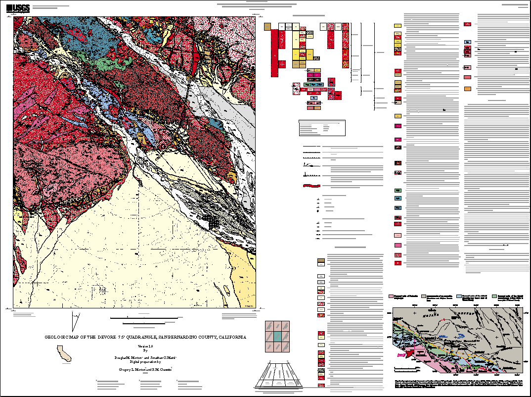
Attribute_Label: LABL
Attribute_Definition: geologic map unit label, in plain text
Attribute_Domain_Values:
Enumerated_Domain:
Enumerated_Domain_Value: Kg
Enumerated_Domain_Value_Definition: Monzogranite and granodiorite
Attribute_Domain_Values:
Enumerated_Domain:
Enumerated_Domain_Value: Kgc
Enumerated_Domain_Value_Definition: Mylonitic leucogranite
Attribute_Domain_Values:
Enumerated_Domain:
Enumerated_Domain_Value: Kgm
Enumerated_Domain_Value_Definition: Leucocratic muscovite monzogranite
Attribute_Domain_Values:
Enumerated_Domain:
Enumerated_Domain_Value: Kmg
Enumerated_Domain_Value_Definition: Biotite monzogranite
Attribute_Domain_Values:
Enumerated_Domain:
Enumerated_Domain_Value: Kt
Enumerated_Domain_Value_Definition: Tonalite of San Sevaine Lookout
Attribute_Domain_Values:
Enumerated_Domain:
Enumerated_Domain_Value: Ktm1
Enumerated_Domain_Value_Definition: Mylonitized tonalite of San Sevaine Lookout
Attribute_Domain_Values:
Enumerated_Domain:
Enumerated_Domain_Value: Mzgn
Enumerated_Domain_Value_Definition: Gneiss east of San Andreas Fault zone
Attribute_Domain_Values:
Enumerated_Domain:
Enumerated_Domain_Value: Mzpg
Enumerated_Domain_Value_Definition: Greenstone
Attribute_Domain_Values:
Enumerated_Domain:
Enumerated_Domain_Value: Mzps
Enumerated_Domain_Value_Definition: Siliceous schist
Attribute_Domain_Values:
Enumerated_Domain:
Enumerated_Domain_Value: TMztp
Enumerated_Domain_Value_Definition: Pelona Schist and granodiorite of Telegraph Peak
Attribute_Domain_Values:
Enumerated_Domain:
Enumerated_Domain_Value: Mzpw
Enumerated_Domain_Value_Definition: Muscovite schist
Attribute_Domain_Values:
Enumerated_Domain:
Enumerated_Domain_Value: Prg
Enumerated_Domain_Value_Definition: Granulitic gneiss, mylonite, and cataclasite, unretrograded
Attribute_Domain_Values:
Enumerated_Domain:
Enumerated_Domain_Value: Prm
Enumerated_Domain_Value_Definition: Granulitic gneiss, mylonite, and cataclasite
Attribute_Domain_Values:
Enumerated_Domain:
Enumerated_Domain_Value: Pzs
Enumerated_Domain_Value_Definition: Schist and gneiss
Attribute_Domain_Values:
Enumerated_Domain:
Enumerated_Domain_Value: KPzgs
Enumerated_Domain_Value_Definition: Schist, gneiss, monzogranite, and granodiorite
Attribute_Domain_Values:
Enumerated_Domain:
Enumerated_Domain_Value: KPzts
Enumerated_Domain_Value_Definition: Schist, gneiss, and tonalite
Attribute_Domain_Values:
Enumerated_Domain:
Enumerated_Domain_Value: Qaf
Enumerated_Domain_Value_Definition: Artificial fill
Attribute_Domain_Values:
Enumerated_Domain:
Enumerated_Domain_Value: Qc
Enumerated_Domain_Value_Definition: Modern colluvial deposits
Attribute_Domain_Values:
Enumerated_Domain:
Enumerated_Domain_Value: Qf
Enumerated_Domain_Value_Definition: Modern alluvial-fan deposits
Attribute_Domain_Values:
Enumerated_Domain:
Enumerated_Domain_Value: Qf1
Enumerated_Domain_Value_Definition: Modern alluvial-fan deposits, Unit 1
Attribute_Domain_Values:
Enumerated_Domain:
Enumerated_Domain_Value: Qfb
Enumerated_Domain_Value_Definition: Modern alluvial-fan deposits, boulder gravel
Attribute_Domain_Values:
Enumerated_Domain:
Enumerated_Domain_Value: Qfg
Enumerated_Domain_Value_Definition: Modern alluvial-fan deposits, gravel
Attribute_Domain_Values:
Enumerated_Domain:
Enumerated_Domain_Value: Qls
Enumerated_Domain_Value_Definition: Modern landslide deposits
Attribute_Domain_Values:
Enumerated_Domain:
Enumerated_Domain_Value: Qoa
Enumerated_Domain_Value_Definition: Old alluvial-valley deposits
Attribute_Domain_Values:
Enumerated_Domain:
Enumerated_Domain_Value: Qoa1
Enumerated_Domain_Value_Definition: Old alluvial-valley deposits, Unit 1
Attribute_Domain_Values:
Enumerated_Domain:
Enumerated_Domain_Value: Qof
Enumerated_Domain_Value_Definition: Old alluvial-fan deposits
Attribute_Domain_Values:
Enumerated_Domain:
Enumerated_Domain_Value: Qof1b
Enumerated_Domain_Value_Definition: Old alluvial-fan deposits, Unit 1, boulder gravel
Attribute_Domain_Values:
Enumerated_Domain:
Enumerated_Domain_Value: Qof2b
Enumerated_Domain_Value_Definition: Old alluvial-fan deposits, Unit 2, boulder gravel
Attribute_Domain_Values:
Enumerated_Domain:
Enumerated_Domain_Value: Qof3
Enumerated_Domain_Value_Definition: Old alluvial-fan deposits, Unit 3
Attribute_Domain_Values:
Enumerated_Domain:
Enumerated_Domain_Value: Qofb
Enumerated_Domain_Value_Definition: Old alluvial-fan deposits, boulder gravel
Attribute_Domain_Values:
Enumerated_Domain:
Enumerated_Domain_Value: Qols
Enumerated_Domain_Value_Definition: Old landslide deposits
Attribute_Domain_Values:
Enumerated_Domain:
Enumerated_Domain_Value: Qsw
Enumerated_Domain_Value_Definition: Modern slopewash deposits
Attribute_Domain_Values:
Enumerated_Domain:
Enumerated_Domain_Value: Qt
Enumerated_Domain_Value_Definition: Modern talus deposits
Attribute_Domain_Values:
Enumerated_Domain:
Enumerated_Domain_Value: Quarry
Enumerated_Domain_Value_Definition: Disturbed ground
Attribute_Domain_Values:
Enumerated_Domain:
Enumerated_Domain_Value: Qvof
Enumerated_Domain_Value_Definition: Very old alluvial-fan deposits
Attribute_Domain_Values:
Enumerated_Domain:
Enumerated_Domain_Value: Qvof1b
Enumerated_Domain_Value_Definition: Very old alluvial-fan deposits, Unit 1, boulder gravel
Attribute_Domain_Values:
Enumerated_Domain:
Enumerated_Domain_Value: Qvof2
Enumerated_Domain_Value_Definition: Very old alluvial-fan deposits, Unit 2
Attribute_Domain_Values:
Enumerated_Domain:
Enumerated_Domain_Value: Qvof2b
Enumerated_Domain_Value_Definition: Very old alluvial-fan deposits, Unit 2, boulder gravel
Attribute_Domain_Values:
Enumerated_Domain:
Enumerated_Domain_Value: Qvof2g
Enumerated_Domain_Value_Definition: Very old alluvial-fan deposits, Unit 2, gravel
Attribute_Domain_Values:
Enumerated_Domain:
Enumerated_Domain_Value: Qvofb
Enumerated_Domain_Value_Definition: Very old alluvial-fan deposits, boulder gravel
Attribute_Domain_Values:
Enumerated_Domain:
Enumerated_Domain_Value: Qvolsa
Enumerated_Domain_Value_Definition: Very old landslide deposits, arenaceous
Attribute_Domain_Values:
Enumerated_Domain:
Enumerated_Domain_Value: Qvowb
Enumerated_Domain_Value_Definition: Very old wash deposits, boulder gravel
Attribute_Domain_Values:
Enumerated_Domain:
Enumerated_Domain_Value: Qw
Enumerated_Domain_Value_Definition: Modern wash deposits
Attribute_Domain_Values:
Enumerated_Domain:
Enumerated_Domain_Value: Qw1
Enumerated_Domain_Value_Definition: Modern wash deposits, Unit 1
Attribute_Domain_Values:
Enumerated_Domain:
Enumerated_Domain_Value: Qw2
Enumerated_Domain_Value_Definition: Modern wash deposits, Unit 2
Attribute_Domain_Values:
Enumerated_Domain:
Enumerated_Domain_Value: Qw2b
Enumerated_Domain_Value_Definition: Modern wash deposits, Unit 2, boulder gravel
Attribute_Domain_Values:
Enumerated_Domain:
Enumerated_Domain_Value: Qwb
Enumerated_Domain_Value_Definition: Modern wash deposits, boulder gravel
Attribute_Domain_Values:
Enumerated_Domain:
Enumerated_Domain_Value: Qya4
Enumerated_Domain_Value_Definition: Young alluvial-valley deposits, Unit 4
Attribute_Domain_Values:
Enumerated_Domain:
Enumerated_Domain_Value: Qya5
Enumerated_Domain_Value_Definition: Young alluvial-valley deposits, Unit 5
Attribute_Domain_Values:
Enumerated_Domain:
Enumerated_Domain_Value: Qyf
Enumerated_Domain_Value_Definition: Young alluvial-fan deposits
Attribute_Domain_Values:
Enumerated_Domain:
Enumerated_Domain_Value: Qyf1b
Enumerated_Domain_Value_Definition: Young alluvial-fan deposits, Unit 1, boulder gravel
Attribute_Domain_Values:
Enumerated_Domain:
Enumerated_Domain_Value: Qyf2b
Enumerated_Domain_Value_Definition: Young alluvial-fan deposits, Unit 2, boulder gravel
Attribute_Domain_Values:
Enumerated_Domain:
Enumerated_Domain_Value: Qyf3
Enumerated_Domain_Value_Definition: Young alluvial-fan deposits, Unit 3
Attribute_Domain_Values:
Enumerated_Domain:
Enumerated_Domain_Value: Qyf3b
Enumerated_Domain_Value_Definition: Young alluvial-fan deposits, Unit 3, boulder gravel
Attribute_Domain_Values:
Enumerated_Domain:
Enumerated_Domain_Value: Qyf4
Enumerated_Domain_Value_Definition: Young alluvial-fan deposits, Unit 4
Attribute_Domain_Values:
Enumerated_Domain:
Enumerated_Domain_Value: Qyf4b
Enumerated_Domain_Value_Definition: Young alluvial-fan deposits, Unit 4, boulder gravel
Attribute_Domain_Values:
Enumerated_Domain:
Enumerated_Domain_Value: Qyf4g
Enumerated_Domain_Value_Definition: Young alluvial-fan deposits, Unit 4, gravel
Attribute_Domain_Values:
Enumerated_Domain:
Enumerated_Domain_Value: Qyf5
Enumerated_Domain_Value_Definition: Young alluvial-fan deposits, Unit 5
Attribute_Domain_Values:
Enumerated_Domain:
Enumerated_Domain_Value: Qyf5b
Enumerated_Domain_Value_Definition: Young alluvial-fan deposits, Unit 5, boulder gravel
Attribute_Domain_Values:
Enumerated_Domain:
Enumerated_Domain_Value: Qyfb
Enumerated_Domain_Value_Definition: Young alluvial-fan deposits, boulder gravel
Attribute_Domain_Values:
Enumerated_Domain:
Enumerated_Domain_Value: Qyfc
Enumerated_Domain_Value_Definition: Young alluvial-fan deposits, clayey
Attribute_Domain_Values:
Enumerated_Domain:
Enumerated_Domain_Value: Qyfg
Enumerated_Domain_Value_Definition: Young alluvial-fan deposits, gravel
Attribute_Domain_Values:
Enumerated_Domain:
Enumerated_Domain_Value: Qyls
Enumerated_Domain_Value_Definition: Young landslide deposits
Attribute_Domain_Values:
Enumerated_Domain:
Enumerated_Domain_Value: Qyt
Enumerated_Domain_Value_Definition: Young talus deposits
Attribute_Domain_Values:
Enumerated_Domain:
Enumerated_Domain_Value: Qyw
Enumerated_Domain_Value_Definition: Young wash deposits
Attribute_Domain_Values:
Enumerated_Domain:
Enumerated_Domain_Value: Ta
Enumerated_Domain_Value_Definition: Andesitic dikes
Attribute_Domain_Values:
Enumerated_Domain:
Enumerated_Domain_Value: Tc
Enumerated_Domain_Value_Definition: Conglomerate
Attribute_Domain_Values:
Enumerated_Domain:
Enumerated_Domain_Value: Tc1
Enumerated_Domain_Value_Definition: Volcanic-clast conglomerate
Attribute_Domain_Values:
Enumerated_Domain:
Enumerated_Domain_Value: Td3
Enumerated_Domain_Value_Definition: Olivine diabase and gabbro
Attribute_Domain_Values:
Enumerated_Domain:
Enumerated_Domain_Value: Ttd
Enumerated_Domain_Value_Definition: Hypabyssal dike
Attribute_Domain_Values:
Enumerated_Domain:
Enumerated_Domain_Value: Ttp
Enumerated_Domain_Value_Definition: Granodiorite of Telegraph Peak
Attribute_Domain_Values:
Enumerated_Domain:
Enumerated_Domain_Value: Ts
Enumerated_Domain_Value_Definition: Arkosic sandstone
Attribute_Domain_Values:
Enumerated_Domain:
Enumerated_Domain_Value: cgm1
Enumerated_Domain_Value_Definition: Chloritized, cataclastic granitic rock
Attribute_Domain_Values:
Enumerated_Domain:
Enumerated_Domain_Value: fz
Enumerated_Domain_Value_Definition: Crushed rock in fault zones
Attribute_Domain_Values:
Enumerated_Domain:
Enumerated_Domain_Value: gnm
Enumerated_Domain_Value_Definition: Cataclastic gneiss
Attribute_Domain_Values:
Enumerated_Domain:
Enumerated_Domain_Value: m
Enumerated_Domain_Value_Definition: Marble
Attribute:
Attribute_Label: PLABL
Attribute_Definition:
Coded geologic map unit label used to generate plot labels with relevant stratigraphic symbols. The geologic units with LABL designating Mesozoic (Mz), Paleozoic (Pz), and Proterozoic (Pr) have keystroke substitute characters, }, |, and < respectively, that call their corresponding symbols from the Geoage Font Group. Geologic map unit labels will plot on derivative map plots with appropriate stratigraphic symbols if PLABL is used as the source for unit labels. The Geoage Font Group is accessed through geofont.txt. The GeoAge Font Group and relevant information are available by anonymous FTP from: Server: onyx.wr.usgs.gov
Attribute:
Attribute_Label: NAME
Attribute_Definition: Geologic name of map unit (see list under LABL attribute)
Detailed_Description:
Entity_Type:
Entity_Type_Label: devre_geo.aat
Entity_Type_Definition:
Geologic features such as contacts and faults that bound rock-unit polygons (a complete description of each line type is available in the data table, lines.rel.)
Attribute:
Attribute_Label: L-TAG
Attribute_Definition:
Coded alpha-numerical symbol that relates arc to definition of line type in dictionary look-up table (lines.rel). For description of attributes in line classification dictionary, refer to USGS Open-File Report 97-861 (see Entity_and_Attribute_Detail_Citation)
Attribute_Domain_Values:
Enumerated_Domain:
Enumerated_Domain_Value: C1
Enumerated_Domain_Value_Definition: Contact, generic, certain, location meets map accuracy standard
Attribute_Domain_Values:
Enumerated_Domain:
Enumerated_Domain_Value: C100
Enumerated_Domain_Value_Definition: Contact, scratch boundary, metamorphic
Attribute_Domain_Values:
Enumerated_Domain:
Enumerated_Domain_Value: C17
Enumerated_Domain_Value_Definition:
Contact, landslide, certain, location meets map accuracy standard
Attribute_Domain_Values:
Enumerated_Domain:
Enumerated_Domain_Value: C18
Enumerated_Domain_Value_Definition:
Contact, landslide, certain, location may not meet map accuracy standard
Attribute_Domain_Values:
Enumerated_Domain:
Enumerated_Domain_Value: C19
Enumerated_Domain_Value_Definition:
Contact, landslide, inferred, location may not meet map accuracy standard
Attribute_Domain_Values:
Enumerated_Domain:
Enumerated_Domain_Value: C20
Enumerated_Domain_Value_Definition:
Contact, landslide, concealed, location may not meet map accuracy standard
Attribute_Domain_Values:
Enumerated_Domain:
Enumerated_Domain_Value: C29
Enumerated_Domain_Value_Definition:
Contact, sedimentary, certain, location meets map accuracy standard
Attribute_Domain_Values:
Enumerated_Domain:
Enumerated_Domain_Value: C30
Enumerated_Domain_Value_Definition:
Contact, sedimentary, certain, location may not meet map accuracy standard
Attribute_Domain_Values:
Enumerated_Domain:
Enumerated_Domain_Value: C31
Enumerated_Domain_Value_Definition:
Contact, sedimentary, inferred, location may not meet map accuracy standard
Attribute_Domain_Values:
Enumerated_Domain:
Enumerated_Domain_Value: C32
Enumerated_Domain_Value_Definition:
Contact, sedimentary, concealed, location may not meet map accuracy standard
Attribute_Domain_Values:
Enumerated_Domain:
Enumerated_Domain_Value: C34
Enumerated_Domain_Value_Definition:
Contact, sedimentary, questionable, location may not meet map accuracy standard
Attribute_Domain_Values:
Enumerated_Domain:
Enumerated_Domain_Value: C37
Enumerated_Domain_Value_Definition:
Contact, sedimentary, separates terraced alluvial units, certain, location meets map accuracy standard
Attribute_Domain_Values:
Enumerated_Domain:
Enumerated_Domain_Value: C38
Enumerated_Domain_Value_Definition:
Contact, sedimentary, certain, separates terraced alluvial units, location may not meet map accuracy standard
Attribute_Domain_Values:
Enumerated_Domain:
Enumerated_Domain_Value: C49
Enumerated_Domain_Value_Definition: Contact, igneous, location meets map accuracy standard
Attribute_Domain_Values:
Enumerated_Domain:
Enumerated_Domain_Value: C50
Enumerated_Domain_Value_Definition: Contact, igneous, location may not meet map accuracy standard
Attribute_Domain_Values:
Enumerated_Domain:
Enumerated_Domain_Value: C51
Enumerated_Domain_Value_Definition:
Contact, igneous, inferred, location may not meet map accuracy standard
Attribute_Domain_Values:
Enumerated_Domain:
Enumerated_Domain_Value: C66
Enumerated_Domain_Value_Definition:
Contact, metamorphic, certain, location may not meet map accuracy standard
Attribute_Domain_Values:
Enumerated_Domain:
Enumerated_Domain_Value: C67
Enumerated_Domain_Value_Definition:
Contact, metamorphic, inferred, location may not meet map accuracy standard
Attribute_Domain_Values:
Enumerated_Domain:
Enumerated_Domain_Value: C99
Enumerated_Domain_Value_Definition: Contact, igneous, scratch boundary
Attribute_Domain_Values:
Enumerated_Domain:
Enumerated_Domain_Value: CL1
Enumerated_Domain_Value_Definition: Cartographic line, map boundary
Attribute_Domain_Values:
Enumerated_Domain:
Enumerated_Domain_Value: F1
Enumerated_Domain_Value_Definition:
Fault, high angle, slip unspecified, location meets map accuracy standard
Attribute_Domain_Values:
Enumerated_Domain:
Enumerated_Domain_Value: F11
Enumerated_Domain_Value_Definition:
Fault, high angle, reverse slip, location may not meet map accuracy standard
Attribute_Domain_Values:
Enumerated_Domain:
Enumerated_Domain_Value: F13
Enumerated_Domain_Value_Definition:
Fault, high angle, slip unspecified, inferred, location may not meet map accuracy standard
Attribute_Domain_Values:
Enumerated_Domain:
Enumerated_Domain_Value: F177
Enumerated_Domain_Value_Definition:
Fault, thrust, older over younger, certain, location meets map accuracy standard
Attribute_Domain_Values:
Enumerated_Domain:
Enumerated_Domain_Value: F178
Enumerated_Domain_Value_Definition:
Fault, thrust, older over younger, certain, location may not meet map accuracy standard
Attribute_Domain_Values:
Enumerated_Domain:
Enumerated_Domain_Value: F180
Enumerated_Domain_Value_Definition:
Fault, thrust, older over younger, concealed, location may not meet map accuracy standard
Attribute_Domain_Values:
Enumerated_Domain:
Enumerated_Domain_Value: F182R
Enumerated_Domain_Value_Definition:
Fault, thrust, older over younger, questionable, location may not meet map accuracy standard
Attribute_Domain_Values:
Enumerated_Domain:
Enumerated_Domain_Value: F183R
Enumerated_Domain_Value_Definition:
Fault, thrust, older over younger, questionable, concealed, location may not meet map accuracy standard
Attribute_Domain_Values:
Enumerated_Domain:
Enumerated_Domain_Value: F19
Enumerated_Domain_Value_Definition:
Fault, high angle, slip unspecified, concealed, location may not meet map accuracy standard
Attribute_Domain_Values:
Enumerated_Domain:
Enumerated_Domain_Value: F193
Enumerated_Domain_Value_Definition:
Fault, thrust, older over younger, scarp, certain, location meets map accuracy standard
Attribute_Domain_Values:
Enumerated_Domain:
Enumerated_Domain_Value: F2
Enumerated_Domain_Value_Definition:
Fault, high angle, right lateral strike slip, certain, location meets map accuracy standard
Attribute_Domain_Values:
Enumerated_Domain:
Enumerated_Domain_Value: F20
Enumerated_Domain_Value_Definition:
Fault, high angle, right lateral strike slip, concealed, location may not meet map accuracy standard
Attribute_Domain_Values:
Enumerated_Domain:
Enumerated_Domain_Value: F37
Enumerated_Domain_Value_Definition:
Fault, high angle, slip unspecified, questionable, concealed, location may not meet map accuracy standard
Attribute_Domain_Values:
Enumerated_Domain:
Enumerated_Domain_Value: F44
Enumerated_Domain_Value_Definition:
Fault, high angle, right lateral strike slip, questionable, concealed, location may not meet map accuracy standard
Attribute_Domain_Values:
Enumerated_Domain:
Enumerated_Domain_Value: F49
Enumerated_Domain_Value_Definition:
Fault, high angle, slip unspecified, scarp, certain, location meets map accuracy standard
Attribute_Domain_Values:
Enumerated_Domain:
Enumerated_Domain_Value: F50
Enumerated_Domain_Value_Definition:
Fault, high angle, right lateral strike slip, scarp, certain, location meets map accuracy standard
Attribute_Domain_Values:
Enumerated_Domain:
Enumerated_Domain_Value: F55
Enumerated_Domain_Value_Definition:
Fault, high angle, slip unspecified, scarp, certain, location may not meet map accuracy standard
Attribute_Domain_Values:
Enumerated_Domain:
Enumerated_Domain_Value: F56
Enumerated_Domain_Value_Definition:
Fault, high angle, right lateral strike slip, scarp, certain, location may not meet map accuracy standard
Attribute_Domain_Values:
Enumerated_Domain:
Enumerated_Domain_Value: F61R
Enumerated_Domain_Value_Definition:
Fault, high angle, slip unspecified, scarp, questionable, location may not meet map accuracy standard
Attribute_Domain_Values:
Enumerated_Domain:
Enumerated_Domain_Value: F7
Enumerated_Domain_Value_Definition:
Fault, high angle, slip unspecified, certain, location may not meet map accuracy standard
Attribute_Domain_Values:
Enumerated_Domain:
Enumerated_Domain_Value: F8
Enumerated_Domain_Value_Definition:
Fault, high angle, right lateral strike slip, certain, location meets map accuracy standard
Attribute_Domain_Values:
Enumerated_Domain:
Enumerated_Domain_Value: GF9
Enumerated_Domain_Value_Definition:
Geomorphic feature, ground failure crown scarp, located well but may not meet map accuracy standard
Attribute:
Attribute_Label: L-SYMB
Attribute_Definition:
stores appropriate line symbol value from the lineset geoscamp2.lin
Attribute:
Attribute_Label: L-NAME
Attribute_Definition: Formal name of fault
Detailed_Description:
Entity_Type:
Entity_Type_Label: devre_str.pat
Entity_Type_Definition:
Geological point data includes site-specific information describing the types and the orientation of bedding, foliation, and lineations. One annotation subclass is included in the geologic points coverage, DEVRE_STR: anno.dip displays the respective dip and plunge values associated with individual point data.
Attribute:
Attribute_Label: P-TAG
Attribute_Definition:
Coded alpha-numerical value that relates point entity to definition of point type in dictionary INFO table, points.rel. For description of attributes in point classification dictionary, refer to USGS Open-File Report 97-859 (see Entity_and_Attribute_Detail_Citation)
Attribute_Domain_Values:
Enumerated_Domain:
Enumerated_Domain_Value: B1
Enumerated_Domain_Value_Definition: Bedding, sedimentary, horizontal
Attribute_Domain_Values:
Enumerated_Domain:
Enumerated_Domain_Value: B2
Enumerated_Domain_Value_Definition: Bedding, sedimentary, inclined
Attribute_Domain_Values:
Enumerated_Domain:
Enumerated_Domain_Value: B4
Enumerated_Domain_Value_Definition: Bedding, sedimentary, vertical
Attribute_Domain_Values:
Enumerated_Domain:
Enumerated_Domain_Value: B6
Enumerated_Domain_Value_Definition: Bedding, sedimentary, overturned
Attribute_Domain_Values:
Enumerated_Domain:
Enumerated_Domain_Value: FC4
Enumerated_Domain_Value_Definition: Direction and dip of fault
Attribute_Domain_Values:
Enumerated_Domain:
Enumerated_Domain_Value: FN42
Enumerated_Domain_Value_Definition: Foliation, metamorphic, inclined
Attribute_Domain_Values:
Enumerated_Domain:
Enumerated_Domain_Value: FN43
Enumerated_Domain_Value_Definition: Foliation, metamorphic, vertical
Attribute_Domain_Values:
Enumerated_Domain:
Enumerated_Domain_Value: L10
Enumerated_Domain_Value_Definition: Lineation, metamorphic, horizontal
Attribute_Domain_Values:
Enumerated_Domain:
Enumerated_Domain_Value: L22
Enumerated_Domain_Value_Definition: Lineation, metamorphic, aligned mineral grains
Attribute_Domain_Values:
Enumerated_Domain:
Enumerated_Domain_Value: L66
Enumerated_Domain_Value_Definition: Lineation, unspecified
Attribute:
Attribute_Label: P-SYMB
Attribute_Definition:
Coded integer value that relates point to cartographic point symbol in markerset geoscamp2.mrk
Attribute:
Attribute_Label: P-STRIKE
Attribute_Definition: Azimuthal strike of planar feature
Attribute:
Attribute_Label: P-DIP
Attribute_Definition: Dip of planar feature
Attribute:
Attribute_Label: P-DIPDIR
Attribute_Definition: Azimuthal direction of dip of planar feature
Attribute:
Attribute_Label: P-PLUNGE
Attribute_Definition: Plunge of linear feature
Attribute:
Attribute_Label: P-BEARING
Attribute_Definition: Azimuthal direction of plunge of linear feature
Detailed_Description:
Entity_Type:
Entity_Type_Label: devre_ldr.aat
Entity_Type_Definition: Annotation leaders
Attribute:
Attribute_Label: L-SYMB
Attribute_Definition:
Coded integer value (1) that relates arcs to cartographic line symbol in lineset geoscamp2.lin
Distribution_Information:
Distributor:
Contact_Information:
Contact_Organization_Primary:
Contact_Organization: U.S. Geological Survey Information Services
Contact_Address:
Address_Type: mailing address
Address: Box 25286 Denver Federal Center
City: Denver
State_or_Province: CO
Postal_Code: 80225
Country: USA
Contact_Voice_Telephone: 303-202-4700
Contact_Facsimile_Telephone: 303-202-4693

Resource_Description: USGS Open-File Report 01-173
Distribution_Liability:
The U.S. Geological Survey (USGS) provides these geographic data "as is." The USGS makes no guarantee or warranty concerning the accuracy of information contained in the geographic data. The USGS further makes no warranties, either expressed or implied as to any other matter whatsoever, including, without limitation, the condition of the product, or its fitness for any particular purpose. The burden for determining fitness for use lies entirely with the user. Although these data have been processed successfully on computers at the USGS, no warranty, expressed or implied, is made by the USGS regarding the use of these data on any other system, nor does the fact of distribution constitute or imply any such warranty.
In no event shall the USGS have any liability whatsoever for payment of any consequential, incidental, indirect, special, or tort damages of any kind, including, but not limited to, any loss of profits arising out of use of or reliance on the geographic data or arising out of the delivery, installation, operation, or support by USGS.
This digital, geologic map database of the San Bernardino North 7.5' quadrangle, 1:24,000 map-scale, and any derivative maps thereof, is not meant to be used or displayed at any scale larger than 1:24,000 (e.g., 1:12,000).
Standard_Order_Process:
Digital_Form:
Digital_Transfer_Information:
Format_Name: ARCE
Format_Version_Number: 7.2.1
Format_Information_Content: Geologic units, structural features, associated database tables
File_Decompression_Technique: tar and gzip
Transfer_Size: 2.6
Digital_Transfer_Option:
Online_Option:
Computer_Contact_Information:
Network_Address:
Fees: none
Metadata_Reference_Information:
Metadata_Date: 20160613
Metadata_Contact:
Contact_Information:
Contact_Person_Primary:
Contact_Person: Peter N Schweitzer
Contact_Organization: USGS Midwest Area
Contact_Position:
Collection manager, USGS Geoscience Data Clearinghouse, http://geo-nsdi.er.usgs.gov/
Contact_Address:
Address_Type: mailing address
Address:
Mail Stop 954
12201 Sunrise Valley Dr
City: Reston
State_or_Province: VA
Postal_Code: 20192-0002
Country: USA
Contact_Voice_Telephone: 703-648-6533
Contact_Facsimile_Telephone: 703-648-6252
Contact_Electronic_Mail_Address: pschweitzer@usgs.gov
Metadata_Standard_Name: Content Standard for Digital Geospatial Metadata
Metadata_Standard_Version: FGDC-STD-001-1998
Metadata_Access_Constraints: none
Metadata_Use_Constraints: none

This page is <https://geo-nsdi.er.usgs.gov/metadata/open-file/01-173/metadata.html>
Generated by mp version 2.9.48 on Tue Jul 03 20:05:36 2018