Citation:
Citation_Information:
Originator: Fred K. Miller
Publication_Date: 2001
Title:
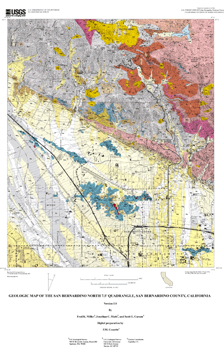
Geologic Map of the San Bernardino North 7.5' quadrangle, San Bernardino County, California
Edition: Version 1.0
Geospatial_Data_Presentation_Form: vector digital data
Series_Information:
Series_Name: U.S. Geological Survey Open-File Report
Issue_Identification: 01-131
Publication_Information:
Publication_Place: Menlo Park, California
Publisher: U.S. Geological Survey
Online_Linkage: http://pubs.usgs.gov/of/2001/0131/
Description:
Abstract:
This data set maps and describes the geology of the San Bernardino North 7.5' quadrangle,
San Bernardino County, California. Created using Environmental Systems Research
Institute's ARC/INFO software, the data base consists of the following items: (1) a map
coverage containing geologic contacts and units, (2) attribute tables for geologic units
(polygons), contacts (arcs), and site-specific data (points). In addition, the data set
includes the following graphic and text products: (1) A PostScript graphic plot-file
containing the geologic map, topography, cultural data, a Correlation of Map Units (CMU)
diagram, a Description of Map Units (DMU), an index map, a regional geologic and
structure map, and a key for point and line symbols; (2) PDF files of this Readme
(including the metadata file as an appendix), Description of Map Units (DMU), and the
graphic produced by the PostScript plot file.
The geologic map covers a part of the southwestern San Bernardino Mountains and the
northwestern San Bernardino basin. Granitic and metamorphic rocks underlie most of the
mountain area, and a complex array of Quaternary deposits fill the basin. These two
areas are separated by strands of the seismically active San Andreas Fault. Bedrock
units in the San Bernardino Mountains are dominated by large Cretaceous and Jurassic
granitic bodies, ranging in composition from monzogranite to monzodiorite, and include
lesser Triassic monzonite. The younger of these granitic rocks intrude a complex
assemblage of gneiss, marble, and granitic rock of probable early Mesozoic age; the
relationship between these metemorphic rocks and the Triassic rocks is unknown. Spanning
the Pleistocene in age, large and small alluvial bodies emerge from the San Bernardino
Mountains, and and fill the San Bernardino basin. In the southwestern part of the
quadrangle, Cajon Wash carries sediments from both the San Bernardino and San Gabriel
Mountains, and Lytle Creek heads in the eastern San Gabriel Mountains. Limited bedrock
areas showing through the Quaternary sediments of the basin consist exclusively of
Mesozoic Pelona Schist locally intruded by Tertairy dikes. Youthful-appearing fault
scarps discontinuously mark the traces of the San Andreas Fault along the southern edge
of the San Bernardino Mountains. Unnamed Tertiary sedimentary rocks are bounded by two
strands of the fault between Badger Canyon and the east edge of the quadrangle. Young
and old high-angle faults cut bedrock units within the San Bernardino Mountains, and the
buried, seismically active San Jacinto Fault traverses the southwestern part of the
quadrangle.
The geologic map database contains original U.S. Geological Survey data generated by
detailed field observation and by interpretation of aerial photographs. This digital
Open-File map superceeds an older analog Open-File map of the quadrangle, and includes
extensive new data on the Quaternary deposits, and revises some fault and bedrock
distribution within the San Bernardino Mountains. The digital map was compiled on a
base-stable cronoflex copy of the San Bernardino North 7.5' topographic base and then
scribed. This scribe guide was used to make a 0.007 mil blackline clear-film, which was
scanned at 1200 DPI by Optronics Specialty Company, Northridge, California; minor
hand-digitized additions were made at the USGS. Lines, points, and polygonswere
subsequently edited at the USGS using standard ARC/INFO commands. Digitizing and editing
artifacts significant enough to display at a scale of 1:24,000 were corrected. Within
the database, geologic contacts are represented as lines (arcs), geologic units as
polygons, and site-specific data as points. Polygon, arc, and point attribute tables
(.pat, .aat, and .pat, respectively) uniquely identify each geologic datum.
Purpose:
The data set for the San Bernardino North 7.5' quadrangle was prepared under the U.S.
Geological Survey Southern California Areal Mapping Project (SCAMP) as part of an ongoing
effort to develop a regional geologic framework of southern California, and to utilize a
Geographical Information System (GIS) format to create regional digital geologic databases.
These regional databases are being developed as contributions to the National Geologic Map
Database of the National Cooperative Geologic Mapping Program of the USGS.
The digital geologic map database for the San Bernardino North 7.5' quadrangle has been
created as a general-purpose data set that is applicable to other land-related
investigations in the earth and biological sciences. For example, it can be used for
groundwater studies in the San Bernardino basin, and for mineral resource evaluation
studies, animal and plant habitat studies, and soil studies in the San Bernardino National
Forest. The database is not suitable for site-specific geologic evaluations.
Time_Period_of_Content:
Time_Period_Information:
Range_of_Dates/Times:
Beginning_Date: 19740401
Ending_Date: 19810801
Currentness_Reference: New data and previously published data
Status:
Progress: Complete
Maintenance_and_Update_Frequency: As needed
Spatial_Domain:
Bounding_Coordinates:
West_Bounding_Coordinate: -117.37509226
East_Bounding_Coordinate: -117.24990774
North_Bounding_Coordinate: 34.24999995
South_Bounding_Coordinate: 34.1249841
Keywords:
Theme:
Theme_Keyword_Thesaurus: USGS Thesaurus
Theme_Keyword: geology
Theme_Keyword: geologic maps
Theme_Keyword: bedrock geologic units
Theme_Keyword: surficial geologic units
Theme_Keyword: geologic structure
Theme_Keyword: geospatial datasets
Theme:
Theme_Keyword_Thesaurus: none
Theme_Keyword: San Andreas Fault
Theme_Keyword: Triassic monzonite
Theme_Keyword: Jurassic granitic rocks
Theme_Keyword: Pelona Schist
Theme:
Theme_Keyword_Thesaurus: ISO 19115 Topic Categories
Theme_Keyword: geoscientificInformation
Place:
Place_Keyword_Thesaurus: none
Place_Keyword: California
Place_Keyword: San Bernardino County
Place_Keyword: San Bernardino North 7.5' quadrangle
Place:
Place_Keyword_Thesaurus: Augmented FIPS 10-4 and FIPS 6-4
Place_Keyword: f06071 = San Bernardino
Access_Constraints: None
Use_Constraints:
The San Bernardino North 7.5' geologic-map database should be used to evaluate and
understand the geologic character of the San Bernardino North 7.5' quadrangle as a whole.
The data should not be used for purposes of site-specific land-use planning or
site-specific geologic evaluations. The database is sufficiently detailed to identify and
characterize geologic materials and structures. However, it is not sufficiently detailed
for site-specific determinations.
Use of this digital geologic map database should not violate the spatial resolution of the
data. Although the digital form of the data removes the constraint imposed by the scale of
a paper map, the detail and accuracy inherent in map scale are also present in the digital
data. The fact that this database was compiled and edited at a scale of 1:24,000 means
that higher resolution information may not have been uniformly retained in the dataset.
Plotting at scales larger than 1:24,000 will not yield greater real detail, although it may
reveal fine-scale irregularities below the intended resolution of the database. Similarly,
although higher resolution data is incorporated in parts of the map, the resolution of the
combined output will be limited by the lower resolution data.
Point_of_Contact:
Contact_Information:
Contact_Person_Primary:
Contact_Person: Fred K. Miller
Contact_Organization:
U.S. Geological Survey, Western Region, Earth Surface Processes Team
Contact_Position: Project geologist
Contact_Address:
Address_Type: mailing address
Address:
U.S. Geological Survey
Room 202
West 904 Riverside Avenue
City: Spokane
State_or_Province: Washington
Postal_Code: 99201-1087
Country: United States of America
Contact_Voice_Telephone: (509) 368-3121
Contact_Facsimile_Telephone: (509) 368-3199
Contact_Electronic_Mail_Address: fmiller@usgs.gov
Browse_Graphic:
Data_Set_Credit:
Technical review by D. M. Morton led to significant improvements that eventually were
reflected in aspects of the database, the plot file, and in the description of the geologic
units of the San Bernardino North 7.5' quadrangle.
Geologic mapping and digital preparation of this report were sponsored jointly by (1) the
National Cooperative Geologic Mapping Program of the U.S. Geological Survey, (2) the
California Division of Mines and Geology, and (3) the Southern California Areal Mapping
Project (SCAMP). In our digital preparation of the data set, carried out in the Geographic
Information System laboratory of the Mineral Resources Program of the U.S. Geological
Survey in Spokane, Washington by Pamela M. Cossette, we received valuable assistance from
Paul C. Hyndman in Spokane, Washington, and from Rachel Hauser at the SCAMP Geographic
Information System laboratory in Riverside, California.
Native_Data_Set_Environment:
SunOS, 5.7, sun4u UNIX
ARC/INFO version 7.2.1
Cross_Reference:
Citation_Information:
Originator: Fred K. Miller
Publication_Date: 1979
Title: Geologic map of the San Bernardino North quadrangle, California
Geospatial_Data_Presentation_Form: analog (paper) map
Series_Information:
Series_Name: U.S. Geological Survey Open-File Report
Issue_Identification: 79-770
Publication_Information:
Publication_Place: Menlo Park, California
Publisher: U.S. Geological Survey