Bedrock geologic map of the Hubbard Brook Experimental Forest, Grafton County, New Hampshire

Metadata also available as - [Questions & Answers] - [Parseable text] - [XML]

Metadata:

Identification_Information:
Citation:
Citation_Information:
Originator: William C. Burton
Originator: Gregory J. Walsh
Originator: Thomas R. Armstrong
Publication_Date: 2000
Title:
Bedrock geologic map of the Hubbard Brook Experimental Forest, Grafton County, New Hampshire
Edition: 1.0
Geospatial_Data_Presentation_Form: map
Series_Information:
Series_Name: U.S. Geological Survey Open-File Report
Issue_Identification: 00-45
Publication_Information:
Publication_Place: Reston, Virginia
Publisher: U.S. Geological Survey
Online_Linkage: http://pubs.usgs.gov/of/2000/of00-045/
Description:
Abstract:
The bedrock geology of the Hubbard Brook Experimental Forest, Grafton County, New Hampshire is described in this report of new field investigation. The database includes contacts of bedrock geologic units, faults, folds, and other structural geologic information, as well as the base maps on which the mapped geological features are registered. This report supersedes Barton (1997).
Purpose:
Our mapping study was funded by the USGS Toxic Substances Hydrology Program and was undertaken for the following reasons: 1) to ascertain whether the area might have a greater number of mappable lithologic units than shown on Barton's (1997) map, and to verify the stratigraphically higher formations shown on the map; 2) to have sufficient data to draw geologic cross- sections through the Mirror Lake research site; 3) to gather more data on brittle fracture distribution and orientation; and 4) to assess the degree to which the subsurface lithologies, ductile structures, and fractures observed at the two Mirror Lake well fields correlate with the geology of the surrounding region.
Supplemental_Information:
Data were originally collected in UTM coordinates, zone 19, NAD 1927, and reprojected to geographic coordinates (Lat/Long), NAD 1983. The database is accompanied by two large format color maps, a readme.txt file, and a explanatory pamphlet.
Point_of_Contact:
Contact_Information:
Contact_Person_Primary:
Contact_Person: Gregory J Walsh
Contact_Organization: U.S. Geological Survey
Contact_Address:
Address_Type: mailing address
Address: P.O. Box 628
City: Montpelier
State_or_Province: VT
Postal_Code: 05602
Country: USA
Contact_Voice_Telephone: 802-828-4514
Contact_Electronic_Mail_Address: gwalsh@usgs.gov
Browse_Graphic:
Browse_Graphic_File_Name: http://pubs.usgs.gov/of/2000/of00-045/0045p1p.gif
Browse_Graphic_File_Description:
Reduced-size image showing the general layout of map sheet 1. 864x485 pixels, 24-bit color.
Browse_Graphic_File_Type: GIF
Browse_Graphic:
Browse_Graphic_File_Name: http://pubs.usgs.gov/of/2000/of00-045/0045p2p.gif
Browse_Graphic_File_Description:
Reduced-size image showing the general layout of map sheet 2. 864x537 pixels, 24-bit color.
Browse_Graphic_File_Type: GIF
Data_Set_Structure:
Data_Set_Part:
Part_Name: Geologic map data
Part_Type: Arc/Info coverages
Part_Description: These coverages provide the scientific content of the mapped data.
Data_Set_Part:
Part_Name: CONTX.E00
Part_Type: Arc/Info coverage (export file)
Part_Description: Polygon coverage for the contacts of geologic map units
Data_Set_Part:
Part_Name: FAULTS.E00
Part_Type: Arc/Info coverage (export file)
Part_Description: Line coverage of geologic faults
Data_Set_Part:
Part_Name: LINES.E00
Part_Type: Arc/Info coverage (export file)
Part_Description: Line coverage for axial traces, isograds, and cross-section lines
Data_Set_Part:
Part_Name: NEAT.E00
Part_Type: Arc/Info coverage (export file)
Part_Description: Polygon coverage for neatline boundary
Data_Set_Part:
Part_Name: OUTCX.E00
Part_Type: Arc/Info coverage (export file)
Part_Description: Polygon coverage for outcrops
Data_Set_Part:
Part_Name: POINT.E00
Part_Type: Arc/Info coverage (export file)
Part_Description: Point coverage for all structural data (original data set)
Data_Set_Part:
Part_Name: STRUX.E00
Part_Type: Arc/Info coverage (export file)
Part_Description: Point coverage for structure data shown on Plate 1 (used for cartography)
Data_Set_Part:
Part_Name: Base map
Part_Type: Arc/Info coverages
Part_Description:
These coverages provide the base map to which the geologic
information is geographically registered.
Data_Set_Part:
Part_Name: BOUNDS.E00
Part_Type: Arc/Info coverage (export file)
Part_Description: Polygon coverage of political boundary of the Hubbard Brook Experimental Forest
Data_Set_Part:
Part_Name: HYDRO.E00
Part_Type: Arc/Info coverage (export file)
Part_Description: Line coverage of surface water hydrography
Data_Set_Part:
Part_Name: ROADS.E00
Part_Type: Arc/Info coverage (export file)
Part_Description: Line coverage of roads.
Data_Set_Part:
Part_Name: TOPO.E00
Part_Type: Arc/Info coverage (export file)
Part_Description: Line coverage for hypsography. Elevations are attributed. Ten foot contour interval.
Data_Set_Part:
Part_Name: WELLS.E00
Part_Type: Arc/Info coverage (export file)
Part_Description: Point coverage of groundwater wells.
Time_Period_of_Content:
Time_Period_Information:
Range_of_Dates/Times:
Beginning_Date: 1998
Ending_Date: 2000
Currentness_Reference: publication date
Status:
Progress: Complete
Maintenance_and_Update_Frequency: None Planned
Spatial_Domain:
Bounding_Coordinates:
West_Bounding_Coordinate: -71.875
East_Bounding_Coordinate: -71.625
North_Bounding_Coordinate: 44.000
South_Bounding_Coordinate: 43.875
Keywords:
Theme:
Theme_Keyword_Thesaurus: USGS Thesaurus
Theme_Keyword: geology
Theme_Keyword: geologic maps
Theme_Keyword: geologic structure
Theme_Keyword: bedrock geologic units
Theme_Keyword: geospatial datasets
Theme:
Theme_Keyword_Thesaurus: none
Theme_Keyword: New Hampshire
Theme_Keyword: Grafton
Theme_Keyword: Hubbard Brook
Theme_Keyword: geologic
Theme_Keyword: geology
Theme_Keyword: bedrock
Theme:
Theme_Keyword_Thesaurus: ISO 19115 Topic Categories
Theme_Keyword: geoscientificInformation
Place:
Place_Keyword_Thesaurus: Augmented FIPS 10-4 and FIPS 6-4
Place_Keyword: f33009 = Grafton
Access_Constraints: none
Use_Constraints:
Although all data released in this report have been used by the USGS, no warranty, expressed or implied, is made by the USGS as to the accuracy of the data and related materials and (or) the functioning of the software. Any use of trade, product, or firm names is for descriptive purposes only and does not imply endorsement by the U.S. Government.
Data_Quality_Information:
Logical_Consistency_Report: Polygon and chain-node topology present.
Lineage:
Source_Information:
Source_Citation:
Citation_Information:
Originator: Barton, C.C.
Publication_Date: 1997
Title:
Bedrock geologic map of Hubbard Brook Experimental Forest and maps of fractures and geology in roadcuts along Interstate 93, Grafton County, New Hampshire
Series_Information:
Series_Name: U.S. Geological Survey Miscellaneous Investigations Series Map
Issue_Identification: I-2562
Publication_Information:
Publication_Place: Reston, Virginia
Publisher: U.S. Geological Survey
Source_Scale_Denominator: 12000
Type_of_Source_Media: mylar
Source_Time_Period_of_Content:
Time_Period_Information:
Single_Date/Time:
Calendar_Date: 1997
Source_Currentness_Reference: publication date
Source_Citation_Abbreviation: Barton (1997)
Source_Contribution:
Provided base map data.
Used to produce polygon coverage of political boundary of the Hubbard Brook Experimental Forest,
For line coverage of surface water hydrography (hydro.e00) Some stream locations have been changed slightly from Barton (1997) as the result of remapping using GPS with the Federal precise positioning service.
For line coverage of roads (roads.e00), data were modified from Barton (1997) and road coverages for the Mt. Kineo and Woodstock 7.5-minute quadrangles obtained from the New Hampshire GRANIT system.
For line coverage for hypsography (topo.e00) data were modified from Barton (1997). Modifications include corrections to elevation attributes and combined with original unpublished data from U.S. Forest Service map, 1956. Digitized by Cornell Laboratory for Environmental Applications of Remote Sensing (CLEARS), Center for the Environment, Cornell University, Ithaca, New York.
For point coverage of groundwater wells (wells.e00), some wells have been added to the dataset from Barton (1997). The well locations were obtained by GPS.
Process_Step:
Process_Description:
Geology mapped by Burton, Walsh, and Armstrong in the summer and fall of 1998 and the summer of 1999 at a scale of 1:10,000. Locational information was provided by Rockwell PLGR+96 GPS receivers using the Federal precise positioning service. The line and polygon data were compiled on a mylar and scanned at 400 dpi on an Anatech Eagle 4080T scanner. The raster files (TIF) were converted to vector files (DXF)using GTX OSR version 2.0 raster-to-vector conversion software. The vector files were imported to Arc/Info version 7.2.1. Point data were collected with GPS and hand-held 3COM Palm Pilot III PDA computers. Data from the PDAs were combined in Microsoft Access, and then imported as ASCII text files and DBASE IV (dbf) files into Arc/Info.
Process_Date: 1998
Spatial_Data_Organization_Information:
Direct_Spatial_Reference_Method: Vector
Point_and_Vector_Object_Information:
SDTS_Terms_Description:
SDTS_Point_and_Vector_Object_Type: Entity point
SDTS_Terms_Description:
SDTS_Point_and_Vector_Object_Type: Complete chain
SDTS_Terms_Description:
SDTS_Point_and_Vector_Object_Type: GT-polygon composed of chains
Spatial_Reference_Information:
Horizontal_Coordinate_System_Definition:
Geographic:
Geographic_Coordinate_Units: decimal degrees
Geodetic_Model:
Horizontal_Datum_Name: North American Datum of 1983
Ellipsoid_Name: Geodetic Reference System 80
Semi-major_Axis: 6378137
Denominator_of_Flattening_Ratio: 298.257
Entity_and_Attribute_Information:
Overview_Description:
Entity_and_Attribute_Overview:
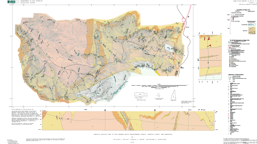
The geologic unit polygons in the CONTX coverage
was filled with colors from the colornames.shd shadeset in
Arc/Info.  A lookup table was created in Arc/Info to fill the
polygons.  The lookup table contains the items CODE and SYMBOL.
Here is the content of the lookup table:
Record  CODE       SYMBOL
     1  Dg         110
     2  Dkg        113
     3  Dp         119
     4  Sp          19
     5  Spp         60
     6  Srb         95
     7  Srcs        47
     8  Srfg        93
     9  Srg         96
    10  Srgt       101
    11  Srlg        49
    12  Srq         84
    13  Srr         79
    14  Srrt        81
    15  Srs         85

The following is a brief description of the ARC/INFO coverages.
GEOLOGIC COVERAGES:
CONTX coverage:
 Item CODE in CONTX.PAT contains the map unit designators.
     (Srb, Dkg, etc.)
 Item LBLTXT in CONTX.PAT is used for selective plotting of code
      labels; valid entry is 'n' or item is left blank.
 Item TYPE is a general category of rock type:
      m=metamorphic and p=plutonic
 Item LINTYPE in CONTX.AAT is used for plotting different line types.
      Valid entries are "concealed" where contacts are under water,
      or item is left blank.
      Concealed plotted as dotted line.
      Blank plotted as solid line.
 Look-up table CONTX.LUT contains the following items:
     CODE = map unit designator
     AGE_SORT = a relative number used to sort the units by age
     FORMATION = the formation name
     AGE = geologic age of the map unit
     MAP_UNIT = simplified description of rock type(s)
                (Complete description is in the accompanying text)
 Lithology attribute table CONTX.LITH contains the following items:
     CODE = map unit designator
     SURF_BED = surficial or bedrock unit
     LITHPRI = primary lithology in the map unit
     LITHSEC = secondary lithology in the map unit
     FORM = formation name
     ROCKCLASS = rock type
     AGE = geologic age of the map unit
     FOSSIL
     COLOR
     MINPRI = most characteristic minerals
     MINSEC = additional common minerals
     MINOTH = accessory minerals
     CONTUP
     CONTLOW
     FOLPRI = dominant generation of foliation in the rock
     FOLSEC = subordinate generation of foliation in the rock
     RMPM = regional prograde-metamorphic minerals
     RMRM = regional retrograde-metamorphic minerals
     DEFORMAGE = age of deformation
 After importing the CONTX.E00 file you will find the look-up table
 and the lithology attribute table in the INFO directory.  If you are
 using ArcView you can add the tables to the project by navigating to
 the INFO directory, specifying the INFO file type, and selecting the
 desired table.  If you are using Arc/Info you can access the data in
 the two tables using either the JOINITEM or RELATE operations and the
 INFO item CODE.

Structural geology point coverages POINT and STRUX:
Coverage POINT contains all of the structural data points and the
points in the database are located within the polygons in the outcrop
coverage -- the point locations are the original mapped locations.
Coverages STRUX contains structural data used for cartography on
Plate 1.  The locations of the points in STRUX have been moved from
the original locations in POINT for plotting purposes only.
Any spatial analysis should use the POINT coverage data.
The STRUX coverage contains annotation for dip and plunge values.
The annotation is not present in the POINT coverage.
The PAT files for the point coverages contain the following
user-defined items:

ITEM NAME
STATION     number of field station
POSFMT      position format from PLGR+96 GPS unit
ZONE        UTM zone from PLGR+96 GPS unit
HDATUM      horizontal datum from PLGR+96 GPS unit
HRZERR      horizontal error from PLGR+96 GPS unit
ELEV        elevation from PLGR+96 GPS unit
VDATUM      vertical datum from PLGR+96 GPS unit
ELEVUNIT    elevation unit from PLGR+96 GPS unit
Note on HRZERR --
	The database includes the horizontal accuracy of point
	features as measured and recorded by the PLGR+96 GPS unit.
	The stated accuracy of the PLGR+96 is +/- 16 meters.
Note on POSFMT through ELEVUNIT --
	These fields are recorded by the PLGR+96 GPS unit.  In the
	PAT files, some points do not have entries in these fields.
	These points have been located without the use of GPS.
The following items are described in more detail below:
TYPE
SUB_TYPE
STRIKE      units in degrees
DIP         units in degrees
DIPDIR      units in degrees
REL_AGE
SYMBOL
SYMBOL_ANG  units in degrees
ROTATION
SPACING     units in meters
WIDTH       units in meters
APERTURE    units in meters
MIN1
MIN2
MIN3
CODE        relate item for dikes, same as code in CONTX.PAT and LUT
TOPOFEAT
NO_MSMT     number of multiple measurements for some brittle features

Here is the detailed  explanation of some of the items:
 DIP = dip value (planar data) or plunge value (linear data)
 STRIKE = measured from north in right-hand rule (planar data)
 DIPDIR = Direction of dip (planar data) or trend (linear data)
          measured from north
For STRIKE and DIPDIR:
                                               0
        North = 0                              |
        East = 90                     270 -----|----- 90
        South = 180                            |
        West = 270                            180

SYMBOL_ANG  = refers to a standard cartesian angle measured
   from EAST:
                                              90
        North = 90                            |
        East = 0                     180 -----|----- 0
        South = 270                           |
        West = 180                           270

   SYMBOL_ANG is used for symbol rotation.
   In ARC/INFO calculate pseudo item $angle = symbol_ang
   Planar symbols with symbol_ang = 0 look like this:
                            __________
                                \/
   Linear symbols with symbol_ang = 0 look like this:
                                 ----->
SYMBOL refers to a pattern number in GEOLOGY.MRK.
ROTATION refers to the rotation sense of minor folds as viewed
down plunge or offset on minor faults.  Valid entries are:
     clockwise (right-lateral) = cw
     counterclockwise (left-lateral) = cc
REL_AGE refers to the relative age of fabrics.
Valid entries are: n-1, n, n+1, n+2, etc.
TYPE refers to the general type of geologic structure.
Valid entries are: planar, linear, or other
SUB_TYPE refers to the specific geologic structure.
Valid entries used in this report arranged by TYPE:
Record  CASE# FREQUENCY TYPE       SUB_TYPE
     1      1     4     linear     elongation
     2      2    76     linear     fold axis
     3      3    14     linear     glacial grooves
     4      4     6     linear     intersection lineation
     5      5     5     linear     mineral lineation
     6      6     1     linear     refolded fold axis
     7      7    13     linear     slickensides
     8      8     1     other      spring
     9      9    79     planar     axial surface
    10     10    28     planar     bedding
    11     11    22     planar     cleavage
    12     12    11     planar     deformed schistosity
    13     13    76     planar     dike
    14     14     2     planar     fault
    15     15    22     planar     foliation
    16     16     4     planar     graded bedding
    17     17    17     planar     igneous flow foliation
    18     18  1579     planar     joint
    19     19    17     planar     joint set
    20     20    24     planar     joint zone
    21     21    76     planar     layer parallel schistosity
    22     22     3     planar     mylonite
    23     23    13     planar     normal fault
    24     24     4     planar     overturned bedding
    25     25     1     planar     refolded axial surface
    26     26     1     planar     reverse fault
    27     27   599     planar     schistosity
    28     28    24     planar     vein
The following are also used in the POINT coverage:
SPACING	spacing of joints in joint sets in meters
WIDTH		width of joint zone or thickness of dike in meters
APERTURE	aperture of joint openings in meters
The following are used in the POINT coverage to describe minerals
on joint surfaces and in veins:
MIN1		primary mineral
MIN2		secondary mineral
MIN3		tertiary mineral
The following values are used in the report, some were modified
after Kretz (1983):
ank   ankerite
dol   dolomite
hem   hematite
lm    limonite
ms    muscovite
pyl   pyrolusite
qtz   quartz
sil   sillimanite
sul   sulfides
tur   tourmaline
Kretz, R., 1983, Symbols for rock-forming minerals: American
Mineralogist, v. 68, nos. 1-2, p. 277-279.

TOPOFEAT	topographic feature parallel to geologic structure
Values used in this report include:
cliff
stream
joint face

Line coverage FAULT contains the following item:
  TYPE = type of fault (normal, reverse, thrust, etc.)

Line coverage LINES contains the following item:
  TYPE = type of geologic line (axial traces, folds, isograds, cross-section lines, etc.)

Polygon coverage NEAT represents the neat line boundary of the Hubbard Brook Experimental Forest project area

Polygon coverage OUTCX represents the location of bedrock outcrops within the Hubbard Brook Experimental Forest project area

BASE MAP COVERAGES:
Polygon coverage BOUNDS represents the political boundary of the Hubbard Brook Experimental Forest

Line and polygon coverage HYDRO represents the surface water hydrography within the Hubbard Brook Experimental Forest

Line coverage ROADS contains the following items:
  GRANITID = GRANIT-assigned feature number
  CLASS = GRANIT-assigned feature number

Line coverage TOPO contains the following items:
  ELEV = elevation in feet above mean sea level
  CI = contour interval (in feet) used for plotting
  SYMBOL = line symbol used for plotting

Point coverage WELLS contains the following items:
  ROCKTYPE = Lower Rangeley (lr), Upper Rangeley (ur), and Concord Granite (cg)
  SYMB = symbol value used for rplotting
  PTYPE = point type (well)
Entity_and_Attribute_Detail_Citation: http://pubs.usgs.gov/of/2000/of00-045/of0045pm.pdf
Distribution_Information:
Distributor:
Contact_Information:
Contact_Organization_Primary:
Contact_Organization: U.S. Geological Survey
Contact_Position: Greg Walsh
Contact_Address:
Address_Type: mailing and physical address
Address: 87 State Street, Room 324
City: Montpelier
State_or_Province: Vermont
Postal_Code: 05602
Country: U.S.A.
Contact_Voice_Telephone: (802) 828-4528
Contact_Facsimile_Telephone: (802) 828-4465
Contact_Electronic_Mail_Address: gwalsh@usgs.gov
Hours_of_Service: Monday - Friday 9:00 - 5:00 EST
Resource_Description: USGS Open-File Report 00-45
Distribution_Liability:
These data were prepared by an agency of the United States Government. Neither the United States Government nor any agency thereof, nor any of their employees, make any warranty, expressed or implied, or assume any legal liability or responsibility for the accuracy, completeness, or usefulness of any information, apparatus, product or process disclosed in this report, and represents that its use would not infringe privately owned rights. The act of distribution shall not constitute any such warranty, and no responsibility is assumed by the USGS in the use of this data or related materials. Reference therein to any specific commercial product, process, or related service by trade name, trademark, manufacturer, or otherwise does not necessarily constitute or imply its endorsement, recommendation, or favoring by the United States Government or any agency thereof.
Standard_Order_Process:
Digital_Form:
Digital_Transfer_Information:
Format_Name: ARCE
Format_Version_Number: 7.2.1
Format_Information_Content:
Geologic contacts and structural features, base map data, along with symbols and markers for use in Arc/Info
File_Decompression_Technique: gzip and tar
Transfer_Size: 5.2
Digital_Transfer_Option:
Online_Option:
Computer_Contact_Information:
Network_Address:
Fees: none
Metadata_Reference_Information:
Metadata_Date: 20160613
Metadata_Review_Date: 20010330
Metadata_Contact:
Contact_Information:
Contact_Organization_Primary:
Contact_Organization: U.S. Geological Survey
Contact_Position: Greg Walsh
Contact_Address:
Address_Type: mailing and physical address
Address: 87 State Street, Room 324
City: Montpelier
State_or_Province: Vermont
Postal_Code: 05602
Country: U.S.A.
Contact_Voice_Telephone: (802) 828-4528
Contact_Facsimile_Telephone: (802) 828-4465
Contact_Electronic_Mail_Address: gwalsh@usgs.gov
Hours_of_Service: Monday - Friday 9:00 - 5:00 EST
Metadata_Standard_Name: Content Standard for Digital Geospatial Metadata
Metadata_Standard_Version: FGDC-STD-001-1998
Metadata_Extensions:

This page is <https://geo-nsdi.er.usgs.gov/metadata/open-file/00-45/metadata.html>
Generated by mp version 2.9.48 on Tue Jul 03 20:05:30 2018