Citation:
Citation_Information:
Originator: Terry L. Tolan
Originator: Marvin H. Beeson
Publication_Date: 2000
Title:
Geologic map and database of the Salem East and Turner 7.5 minute quandrangles, Marion County, Oregon: A digital database
Edition: 1.0
Geospatial_Data_Presentation_Form: vector digital data
Series_Information:
Series_Name: U.S. Geological Survey Open-File Report
Issue_Identification: 00-351
Publication_Information:
Publication_Place: Menlo Park, CA
Publisher: U.S. Geological Survey
Online_Linkage: http://pubs.usgs.gov/of/2000/0351/
Description:
Abstract:
This digital map database, compiled from previously published and
unpublished data, and new mapping by the authors, represents the
general distribution of bedrock and surficial deposits of the Salem
East and Turner 7.5 minute quadrangles. A previously published
adjacent geologic map and database by Tolan, Beeson, and Wheeler
(1999) contains a text file (geol.txt or geol.ps), it provides current
information on the geologic structure and stratigraphy of the area
covered. The database delineates map units that are identified by
general age and lithology following the stratigraphic nomenclature of
the U.S. Geological Survey. The scale of the source maps limits the
spatial resolution (scale) of the database to 1:24,000 or smaller.
Purpose:
This database and accompanying plot files depict the distribution of
geologic materials and structures at a regional (1:24,000) scale.
The report is intended to provide geologic information for the
regional study of materials properties, earthquake shaking, landslide
potential, mineral hazards, seismic velocity, and earthquake faults.
In addition, the report contains new information and interpretations
about the regional geologic history and framework. However, the
regional scale of this report does not provide sufficient detail for
site development purposes. In addition, this map does not take the
place of fault-rupture hazard zones designated by the Oregon State
Geologist (REF?). Similarly, the database cannot be used to identify
or delineate landslides in the region.
Supplemental_Information:
The databases in this report were compiled in ARC/INFO, a commercial
Geographic Information System (Environmental Systems Research
Institute, Redlands, California), with version 3.0 of the menu
interface ALACARTE (Fitzgibbon and Wentworth, 1991, Fitzgibbon, 1991,
Wentworth and Fitzgibbon, 1991). The files are in either GRID (ARC/
INFO raster data) format or COVERAGE (ARC/INFO vector data) format.
Coverages are stored in uncompressed ARC export format (ARC/INFO
version 7.x). ARC/INFO export files (files with the .e00 extension)
can be converted into ARC/INFO coverages in ARC/INFO (see below) and
can be read by some other Geographic Information Systems, such as
MapInfo via ArcLink and ESRI's ArcView (version 1.0 for Windows 3.1
to 3.11 is available for free from ESRI's web site:
http://www.esri.com). The digital compilation was done in version
7.1.1 of ARC/INFO with version 3.0 of the menu interface ALACARTE
(Fitzgibbon and Wentworth, 1991, Fitzgibbon, 1991, Wentworth and
Fitzgibbon, 1991). The geologic map information was digitized from
stable originals of the geologic maps at 1:24,000 scale. The author
manuscripts (pen on mylar and pen on paper) were scanned using a
Anatek rasterizing color scanner with a resolution of 600 and 400
dots per inch. The scanned images were vectorized and transformed
from scanner coordinates to projection coordinates with digital tics
placed by hand at quadrangle corners. The scanned lines were edited
interactively by hand using ALACARTE, color boundaries were tagged
as appropriate, and scanning artifacts visible at 1:24,000 were
removed.
Time_Period_of_Content:
Time_Period_Information:
Single_Date/Time:
Calendar_Date: 2000
Currentness_Reference: publication date
Status:
Progress: Complete
Maintenance_and_Update_Frequency: As needed
Spatial_Domain:
Bounding_Coordinates:
West_Bounding_Coordinate: -123.000020
East_Bounding_Coordinate: -122.874708
North_Bounding_Coordinate: 44.999997
South_Bounding_Coordinate: 44.874995
Keywords:
Theme:
Theme_Keyword_Thesaurus: USGS Thesaurus
Theme_Keyword: geology
Theme_Keyword: geologic maps
Theme_Keyword: bedrock geologic units
Theme_Keyword: surficial geologic units
Theme_Keyword: geologic history
Theme_Keyword: geologic structure
Theme_Keyword: geospatial datasets
Theme:
Theme_Keyword_Thesaurus: none
Theme_Keyword: fault offset
Theme_Keyword: Salem East
Theme_Keyword: Turner
Theme_Keyword: Oregon
Theme:
Theme_Keyword_Thesaurus: ISO 19115 Topic Categories
Theme_Keyword: geoscientificInformation
Place:
Place_Keyword_Thesaurus: none
Place_Keyword: Salem East, Oregon
Place_Keyword: Turner, Oregon
Place_Keyword: Marion County, Oregon
Place:
Place_Keyword_Thesaurus: Augmented FIPS 10-4 and FIPS 6-4
Place_Keyword: f41047 = Marion
Access_Constraints: none
Use_Constraints:
Uses of this digital geologic map should not violate the spatial
resolution of the data. Although the digital form of the data removes
the constraint imposed by the scale of a paper map, the detail and
accuracy inherent in map scale are also present in the digital data.
The fact that this database was edited for a scale of 1:24,000 means
that higher resolution information is not present in the dataset.
Plotting at scales larger than 1:24,000 will not yield greater real
detail, although it may reveal fine-scale irregularities below the
intended resolution of the database. Similarly, where this database is
used in combination with other data of higher resolution, the
resolution of the combined output will be limited by the lower
resolution of these data.
Point_of_Contact:
Contact_Information:
Contact_Person_Primary:
Contact_Person: Chris B DuRoss
Contact_Organization: U.S. Geological Survey
Contact_Address:
Address_Type: mailing address
Address: 345 Middlefield Road, MS 975
City: Menlo Park
State_or_Province: CA
Postal_Code: 94025
Country: USA
Contact_Voice_Telephone: 650-566-9772
Contact_Electronic_Mail_Address: [email protected]
Browse_Graphic:
Browse_Graphic:
Browse_Graphic:
Browse_Graphic_File_Name: http://pubs.usgs.gov/of/2000/0351/pdf/slmfinal.pdf
Browse_Graphic_File_Description:
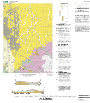
A PDF representation of Sheet 1, the Salem East geologic map at a scale of 1:24,000 and list of map units. 4.1 megabytes
Browse_Graphic_File_Type: PDF
Browse_Graphic:
Browse_Graphic_File_Name: http://pubs.usgs.gov/of/2000/0351/pdf/tnrfinal.pdf
Browse_Graphic_File_Description:
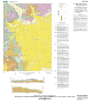
A JPEG representation of Sheet 1, the Turner geologic map at a scale of 1:24,000 and list of map units. 4.2 megabytes
Browse_Graphic_File_Type: PDF
Data_Set_Credit: T.L. Tolan and M.H. Beeson
Native_Data_Set_Environment: UNIX Sun Solaris; ESRI ArcInfo 7.12