Citation:
Citation_Information:
Originator: John C. Dohrenwend
Originator: Floyd Gray
Originator: Robert J. Miller
Publication_Date: 2000
Title:
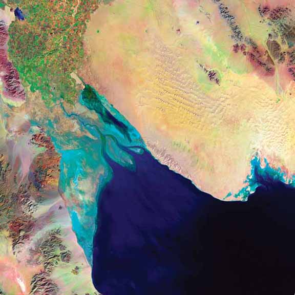
Processed Thematic Mapper satellite imagery for selected areas within the U.S.-Mexico borderlands
Geospatial_Data_Presentation_Form: remote-sensing image
Series_Information:
Series_Name: U.S. Geological Survey Open-File Report
Issue_Identification: 00-309
Publication_Information:
Publication_Place: Menlo Park, CA
Publisher: U.S. Geological Survey
Online_Linkage: http://pubs.usgs.gov/of/2000/of00-309/
Description:
Abstract:
The passage of the North American Trade Agreement (NAFTA),
establishment of the Border Environmental Cooperation Commission
as well as the EPA U.S./Mexico Border XXI Program has focused
attention to the environmental social-cultural, and economic
conditions in the United States-Mexico frontier and to the
enhanced necessity of a binational, transborder approach in
addressing problems. Towards this end, this U.S.-Mexico
borderlands Thematic Mapper selection is designed to be utilized
as fundamental part of a basic geographic information system
database for natural resource, environmental, and land-management
studies.
Purpose:
To provide processed satellite images of key areas along the U.
S.-Mexico border for use in a broad spectrum of studies. Landsat
data have been used by government, commercial, industrial,
civilian, and educational communities in the U.S. and worldwide.
They are being used to support a wide range of applications in
such areas as global change research, agriculture, forestry,
geology, resources management, geography, mapping, water quality,
and oceanography. Landsat data have potential applications for
monitoring the conditions of the Earth's land surface
Time_Period_of_Content:
Time_Period_Information:
Range_of_Dates/Times:
Beginning_Date: 1984
Ending_Date: 1997
Currentness_Reference: ground condition
Status:
Progress: Complete
Maintenance_and_Update_Frequency: None planned
Spatial_Domain:
Bounding_Coordinates:
West_Bounding_Coordinate: -118.00
East_Bounding_Coordinate: -97.00
North_Bounding_Coordinate: 34.00
South_Bounding_Coordinate: 27.00
Keywords:
Theme:
Theme_Keyword_Thesaurus: USGS Thesaurus
Theme_Keyword: geophysics
Theme_Keyword: multispectral imaging
Theme_Keyword: image collections
Theme_Keyword: geospatial datasets
Theme:
Theme_Keyword_Thesaurus: ISO 19115 Topic Categories
Theme_Keyword: geoscientificInformation
Theme:
Theme_Keyword_Thesaurus: none
Theme_Keyword: EARTH SCIENCE
Theme_Keyword: RADIANCE OR IMAGERY
Theme_Keyword: INFRARED WAVELENGTHS
Theme_Keyword: INFRARED IMAGERY
Theme_Keyword: VISIBLE WAVELENGTHS
Theme_Keyword: VISIBLE IMAGERY
Theme_Keyword: DAAC
Theme_Keyword: EDC
Theme_Keyword: EROS
Theme_Keyword: IMAGERY
Theme_Keyword: LANDSAT
Theme_Keyword: RADIANCE
Theme_Keyword: REMOTE SENSING
Theme_Keyword: SATELLITE
Theme_Keyword: SPACE IMAGING EOSAT
Theme_Keyword: THEMATIC MAPPER
Theme_Keyword: TM
Theme_Keyword: USGS
Place:
Place_Keyword_Thesaurus: GCMD Location Keywords
Place_Keyword: NORTH AMERICA
Place:
Place_Keyword_Thesaurus: Augmented FIPS 10-4 and FIPS 6-4
Place_Keyword: MX02 = Baja California
Place_Keyword: MX26 = Sonora
Place_Keyword: MX06 = Chihuahua
Place_Keyword: MX07 = Coahuila de Zaragoza
Place_Keyword: MX19 = Nuevo Leon
Place_Keyword: MX28 = Tamaulipas
Place_Keyword: f04013 = Maricopa
Place_Keyword: f04027 = Yuma
Place_Keyword: f04019 = Pima
Place_Keyword: f04003 = Cochise
Place_Keyword: f04023 = Santa Cruz
Place_Keyword: f06073 = San Diego
Place_Keyword: f06025 = Imperial
Place_Keyword: f35013 = Dona Ana
Place_Keyword: f35023 = Hidalgo
Place_Keyword: f35029 = Luna
Place_Keyword: f48229 = Hudspeth
Place_Keyword: f48141 = El Paso
Place_Keyword: f48043 = Brewster
Place_Keyword: f48443 = Terrell
Place_Keyword: f48377 = Presidio
Place_Keyword: f48465 = Val Verde
Place_Keyword: f48163 = Frio
Place_Keyword: f48507 = Zavala
Place_Keyword: f48323 = Maverick
Place_Keyword: f48283 = La Salle
Place_Keyword: f48127 = Dimmit
Place_Keyword: f48479 = Webb
Place_Keyword: f48131 = Duval
Place_Keyword: f48249 = Jim Wells
Place_Keyword: f48273 = Kleberg
Place_Keyword: f48247 = Jim Hogg
Place_Keyword: f48505 = Zapata
Place_Keyword: f48261 = Kenedy
Place_Keyword: f48047 = Brooks
Place_Keyword: f48427 = Starr
Place_Keyword: f48215 = Hidalgo
Place_Keyword: f48489 = Willacy
Place_Keyword: f48061 = Cameron
Access_Constraints: none
Use_Constraints: none
Point_of_Contact:
Contact_Information:
Contact_Person_Primary:
Contact_Person: Floyd Gray
Contact_Organization: U.S. Geological Survey, GEO-WRG-MRS
Contact_Address:
Address_Type: mailing address
Address: E.N.R Building
City: Tucson
State_or_Province: AZ
Postal_Code: 85719-5035
Country: USA
Contact_Voice_Telephone: 520-670-5582
Contact_Facsimile_Telephone: 520-670-5571
Contact_Electronic_Mail_Address: fgray@usgs.gov
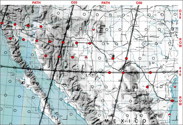
Browse_Graphic:
Browse_Graphic:
Browse_Graphic_File_Name: http://pubs.usgs.gov/of/2000/of00-309/FIGURES/TM_index.jpg
Browse_Graphic_File_Description:
Approximate locations of the centers of the TM scenes. Scenes indicated with a red circle
are included in this dataset. Half filled circles indicate scenes shifted from the normal scene center.
Browse_Graphic_File_Type: JPEG
Cross_Reference:
Citation_Information:
Originator: U.S. Geological Survey
Publication_Date: 2000
Title: Land Satellite (LANDSAT) Multispectral Scanner (MSS)
Geospatial_Data_Presentation_Form: remote-sensing image
Publication_Information:
Publication_Place: Sioux Falls, SD
Publisher: U.S. Geological Survey
Other_Citation_Details:
The concept of a civilian Earth resources satellite was conceived in the Department of Interior in the mid-1960's. The National Aeronautics and Space Administration (NASA) embarked on an initiative to develop and launch the first Earth monitoring satellite to meet the needs of resource managers and Earth scientists. The USGS entered into a partnership with NASA in the early 1970's to assume responsibility for the archive management and distribution of Landsat data products. On July 23, 1972, NASA launched the first in a series of satellites designed to provide repetitive global coverage of the Earth's land masses.
Cross_Reference:
Citation_Information:
Originator: U.S. Geological Survey EROS Data Center
Publication_Date: 1972
Title: LGSOWG Landsat Multispectral Scanner (MSS) Imagery
Edition: 1.0
Geospatial_Data_Presentation_Form: remote-sensing image
Publication_Information:
Publication_Place: Sioux Falls SD
Publisher: U.S. Geological Survey
Other_Citation_Details:
The Global Land Information System (GLIS) and the EOSDIS Information Management System (IMS) are interactive query systems providing information on this data set.