Map of glacial limits and possible refugia in the southern Alexander Archipelago, Alaska, during the late Wisconsin glaciation

Metadata also available as - [Outline] - [Parseable text] - [XML]

Frequently anticipated questions:


What does this data set describe?

Title:
Map of glacial limits and possible refugia in the southern Alexander Archipelago, Alaska, during the late Wisconsin glaciation
Abstract:
During the late Wisconsin glaciation (circa 26,000-13,000 carbon-14 yr BP) the Cordilleran glacier complex formed vast ice fields and large glaciers along the crest of the Coast Mountains. As these glaciers flowed west to the Pacific Ocean, they were joined by local glaciers originating on the higher reaches of the Alexander Archipelago (Mann and Hamiltion, 1995). This extensive volume of ice was channeled into deep troughs (present-day fiords) that formed major outlet glaciers, such as the glaciers that occupied Chatham Strait and Dixon Entrance. In several places along the coast, deep glacially scoured submarine troughs indicate that glaciers reached to the edge of the continental shelf. For instance, the glacier that extended into the Dixon Entrance trough is known to have extended to the edge of the continental shelf. Its retreat began sometime after 16,000-15,000 carbon-14 yr BP (Barrie and Conway, 1999).
The exact extent of late Wisconsin cordilleran ice in southeastern Alaska is poorly known. Small-scale maps and reports of the region commonly show or imply ice extending west to the edge of the continental shelf (Capps, 1931; Coulter and others, 1965; Flint, 1971; Pewe, 1975; Denton and Hughes, 1981; and Prest, 1984). These maps relied heavily on earlier work, much of it of a reconnaissance nature.
The map shows our interpretation of the limit of the Cordilleran ice sheet, which is more restricted than previous estimates, and possible refugium (an area that escaped the extensive glaciation of the late Wisconsin and so provided a suitable habitat for relict species) in the southern Alexander Archipelago during the late Wisconsin glaciation. In addition to the analysis of the bathymetric map, the limits of the Cordilleran ice sheet and possible refugia were also identified by analyses of aerial photographs, USGS topographic maps (1:63,360 and 1:250,000 scales), NOAA bathymetric charts (1:20,000 and 1:40,000 scales), previous literature, and reconnaissance fieldwork throughout the region. Ice-free areas that may have served as refugia include (1) high mountain nunataks (too small to show at map scale), (2) unglaciated ocean-facing slopes and forelands (Dahl, 1946), (3) the outer islands of the Alexander Archipelago (Worley, 1980), and (4) parts of the inner continental shelf exposed by the lowering of sea level during the late Wisconsin by an estimated 125 m (Bard and others, 1990).
Supplemental_Information:
Arc/Info coverages and shapefiles included in this dataset: extents(.shp)--probable Cordilleran ice extents
100m_cont(.shp)--bathymetric contours below -300 meters
25m_cont(.shp)--bathymetric contours above -300 meters
Map political location: Southern Alexander Archipelago, Alaska Compilation scale: 1:500,000 Geology mapped in 2001-2003
  1. How might this data set be cited?
    Carrara, P.E., Ager, T.A., Baichtal, J.F., and VanSistine, D. Paco, 2003, Map of glacial limits and possible refugia in the southern Alexander Archipelago, Alaska, during the late Wisconsin glaciation: U.S. Geological Survey Miscellaneous Field Studies Map MF-2424, U.S. Geological Survey, Denver, Colorado.

    Online Links:

  2. What geographic area does the data set cover?
    West_Bounding_Coordinate: -136.27626612
    East_Bounding_Coordinate: -131.1200724
    North_Bounding_Coordinate: 57.29756559
    South_Bounding_Coordinate: 54.21530596
  3. What does it look like?
    http://pubs.usgs.gov/mf/2003/mf-2424/MF-2424_250_pixel_wide.gif (GIF)
    Reduced-size image of the entire map sheet, 250x157 pixels, 13k bytes.
    http://pubs.usgs.gov/mf/2003/mf-2424/mf-2424.pdf (PDF)
    Printable representation of map layout, 27.5 megabytes
  4. Does the data set describe conditions during a particular time period?
    Calendar_Date: 2003
    Currentness_Reference:
    publication date
  5. What is the general form of this data set?
    Geospatial_Data_Presentation_Form: map
  6. How does the data set represent geographic features?
    1. How are geographic features stored in the data set?
    2. What coordinate system is used to represent geographic features?
      Grid_Coordinate_System_Name: State Plane Coordinate System 1927
      State_Plane_Coordinate_System:
      Oblique_Mercator:
      Scale_Factor_at_Center_Line: 0.999900
      Oblique_Line_Azimuth:
      Azimuth_Measure_Point_Longitude: -133.666667
      Azimuthal_Angle: 36.869898
      Latitude_of_Projection_Origin: 57.0
      False_Easting: 16404166.666667
      False_Northing: -16404166.666667
      SPCS_Zone_Identifier: 6101
      Planar coordinates are encoded using coordinate pair
      Abscissae (x-coordinates) are specified to the nearest 112.65703125
      Ordinates (y-coordinates) are specified to the nearest 112.65703125
      Planar coordinates are specified in Feet
      The horizontal datum used is North American Datum of 1927.
      The ellipsoid used is Clarke 1866.
      The semi-major axis of the ellipsoid used is 6378206.4.
      The flattening of the ellipsoid used is 1/294.98.
  7. How does the data set describe geographic features?
    Entity_and_Attribute_Overview:
    The dataset consists of three coverages:
    EXTENTS (probable Cordilleran ice extents)
    100M_CONT (bathymetric contours below -300 meters)
    25M_CONT (bathymetric contours above -300 meters)
    
    
    <EXTENTS.AAT>
    item explanation:
    DESCRIPTION--short description of line feature
    
    COLUMN   ITEM NAME      WIDTH   OUTPUT   TYPE   N.DEC
    1        FNODE#             4        5      B       -
    5        TNODE#             4        5      B       -
    9        LPOLY#             4        5      B       -
    13       RPOLY#             4        5      B       -
    17       LENGTH             4       12      F       3
    21       EXTENTS#           4        5      B       -
    25       EXTENTS-ID         4        5      B       -
    29       DESCRIPTION      100      100      C       -
    
    DESCRIPTION
    Chatham Strait fault
    Fairweather/Queen Charlotte fault
    probable late Wisconsin Cordilleran ice marginal position
    probable pre-late Wisconsin Cordilleran ice marginal position
    submarine slide scarp
    
    
    <100M_CONT.AAT>
    item explanation:
    CONTOUR--bathymetric contour interval, in meters below sea level
    (100-meter increments)
    
    COLUMN   ITEM NAME      WIDTH   OUTPUT   TYPE   N.DEC
    1        FNODE#             4        5      B       -
    5        TNODE#             4        5      B       -
    9        LPOLY#             4        5      B       -
    13       RPOLY#             4        5      B       -
    17       LENGTH             4       12      F       3
    21       100M_CONT#         4        5      B       -
    25       100M_CONT-ID       4        5      B       -
    29       CONTOUR            8       14      F       0
    
    CONTOUR
    values between -300 and -3100 (100-meter increments)
    
    
    <25M_CONT.AAT>
    item explanation:
    CONTOUR - bathymetric contour interval, in meters below sea level (25-meter increments)
    
    COLUMN   ITEM NAME      WIDTH   OUTPUT   TYPE   N.DEC
    1        FNODE#             4        5      B       -
    5        TNODE#             4        5      B       -
    9        LPOLY#             4        5      B       -
    13       RPOLY#             4        5      B       -
    17       LENGTH             4       12      F       3
    21       25M_CONT#          4        5      B       -
    25       25M_CONT-ID        4        5      B       -
    29       CONTOUR            8       14      F       0
    
    CONTOUR
    values between 0 and -275 (25-meter increments)
    
    Entity_and_Attribute_Detail_Citation: http://pubs.usgs.gov/mf/2003/mf-2424/mf-2424_508.pdf

Who produced the data set?

  1. Who are the originators of the data set? (may include formal authors, digital compilers, and editors)
    • P.E. Carrara
    • T.A. Ager
    • J.F. Baichtal
    • D. Paco VanSistine
  2. Who also contributed to the data set?
    Scientific Fishery Systems, Inc. for providing the digital data base of depth soundings.
  3. To whom should users address questions about the data?
    Paul Carrara
    U.S. Geological Survey
    USGS, Denver Federal Center, MS-980, Box 25046
    Denver, Colorado
    USA

    303-236-1287 (voice)
    pcarrara@usgs.gov

Why was the data set created?

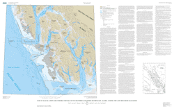
This map, which shows bathymetric contours within the southern part of the Alexander Archipelago, Alaska, has been prepared to show the limits of the Cordilleran ice sheet in this region. Previous bathymetric data for this region showed only individual water depth data (NOAA nautical charts). By producing a bathymetric contour map of this region large geomorphic features are apparent and provide information regarding the glacial history of the region. For instance, large, deep glacial troughs, such as the Chatham Strait trough, indicate that the glacier that occupied this trough flowed to the edge of the continental shelf. Previous studies suggested that during the late Wisconsin glaciation Cordilleran ice overwhelmed the Alexander Archipelago and terminated in one vast ice front at the edge of the continental shelf. Our interpretation, based on the bathymetric contours, indicates that ice reached the continental shelf at only several locations, Chatham Strait and Dixon Entrance, while large areas of the exposed continental shelf and parts of the outer islands may have been ice free.

How was the data set created?

  1. From what previous works were the data drawn?
    none (source 1 of 1)
    Scientific Fishery Systems, Inc, 2000, Alaska Bathymetric Data: Scientific Fishery Systems, Inc, Anchorage, AK.

    Type_of_Source_Media: CD-ROM
    Source_Contribution:
    Digital bathymetric point elevations, used to create bathymetric contours.
  2. How were the data generated, processed, and modified?
    Date: 1997 (process 1 of 7)
    Interpretations of topographic maps and aerial photos, along with field work were done by geologist.
    Date: 2001 (process 2 of 7)
    Contours were created in Arc/Info using bathymetric point data obtained from Scientific Fishery Systems, Inc., at 25-meter and 100-meter intervals.
    Date: 2002 (process 3 of 7)
    Glacial limits were digitized in Arc/Info from bathymetric interpretations drawn by geologist/author on bathymetry map printouts.
    Date: 2002 (process 4 of 7)
    Bathymetric countours and glacial limit arcs were attributed and given line feature descriptions.
    Date: 2003 (process 5 of 7)
    Map printouts were submitted for technical reviews and suggestions/corrections were made to database.
    Date: 2003 (process 6 of 7)
    First draft of metadata created by Paco VanSistine Using FGDCMETA.AML ver. 1.32 01/11/99.
    Date: 2003 (process 7 of 7)
    Creation of original metadata record Person who carried out this activity:
    U.S. Geological Survey
    Attn: Paco VanSistine
    USGS, Denver Federal Center, MS-980, Box 25046
    Denver, CO
    USA

    303-236-5452 (voice)
    dsistine@usgs.gov
  3. What similar or related data should the user be aware of?

How reliable are the data; what problems remain in the data set?

  1. How well have the observations been checked?
    Data were checked by the geologist who made the observations. To check attribute accuracy, a color check plot was visually compared to the geologist's original compilation. Discrepancies between the digital geospatial dataset and the original analog compilation were corrected as needed. This map has been thoroughly reviewed for conformity with U.S. Geological Survey editorial standards and stratigraphic nomenclature.
  2. How accurate are the geographic locations?
    Many points were determined originally by GPS and(or) Loran System. All data used from published and unpublished digital sources are limited by the accuracy of that data. All glacial extents were on- screen digitized from hand-drafted scanned versions drawn on bathymetric map at 1:500,000 scale.
  3. How accurate are the heights or depths?
  4. Where are the gaps in the data? What is missing?
    Data are complete: no features were eliminated or generalized at the scale of map compilation.
  5. How consistent are the relationships among the observations, including topology?
    Map elements were visually checked by the author for overshoots, undershoots, duplicate features, polygon attributes, and other errors. Automated (ARC/INFO) routines were also used to check the databases for polygon label errors, line or point attribution errors, sliver polygons, dangling arcs, intersection errors, and projection information. The map was reviewed by other geologists for consistency with basic geologic principles and general conformity to USGS mapping standards.

How can someone get a copy of the data set?

Are there legal restrictions on access or use of the data?
Access_Constraints: none
Use_Constraints:
none. Acknowledgment of the U.S. Geological Survey would be appreciated in products derived from these data.
  1. Who distributes the data set? (Distributor 1 of 1)
    U.S. Geological Survey
    Central Publications Group
    MS-902, Box 25046
    Denver Federal Center
    Lakewood, CO
    USA

    303-236-5486 (voice)
  2. What's the catalog number I need to order this data set? USGS Miscellaneous Field Studies Map MF-2424
  3. What legal disclaimers am I supposed to read?
    Although these data have been used by the U.S. Geological Survey, U.S. Department of the Interior, no warranty expressed or implied is made by the U.S. Geological Survey as to the accuracy of the data.
    The act of distribution shall not constitute any such warranty, and no responsibility is assumed by the U.S. Geological Survey in the use of this data, software, or related materials.
  4. How can I download or order the data?

Who wrote the metadata?

Dates:
Last modified: 05-Feb-2016
Metadata author:
Peter N Schweitzer
USGS Midwest Area
Collection manager, USGS Geoscience Data Clearinghouse, http://geo-nsdi.er.usgs.gov/
Mail Stop 954
12201 Sunrise Valley Dr
Reston, VA
USA

703-648-6533 (voice)
703-648-6252 (FAX)
pschweitzer@usgs.gov
Metadata standard:
Content Standard for Digital Geospatial Metadata (FGDC-STD-001-1998)

This page is <https://geo-nsdi.er.usgs.gov/metadata/map-mf/2424/metadata.faq.html>
Generated by mp version 2.9.48 on Tue Jul 03 20:05:19 2018