Geologic Map of Upper Clayhole Valley and Vicinity, Mohave County, Northwestern Arizona

Metadata also available as - [Questions & Answers] - [Parseable text] - [XML]

Metadata:

Identification_Information:
Citation:
Citation_Information:
Originator: George H. Billingsley
Originator: Susan S. Priest
Publication_Date: 2003
Title:
Geologic Map of Upper Clayhole Valley and Vicinity, Mohave County, Northwestern Arizona
Edition: Version 1.0
Geospatial_Data_Presentation_Form: geologic map
Series_Information:
Series_Name: U.S. Geological Survey Miscellaneous Field Studies Map
Issue_Identification: MF-2418
Publication_Information:
Publication_Place: Flagstaff, Arizona
Publisher: U.S. Geological Survey
Online_Linkage: http://pubs.usgs.gov/mf/2003/2418/
Description:
Abstract:
This digital map database is compiled from unpublished data and new mapping by the authors and represents the general distribution of surficial and bedrock geology in the mapped area. Together with the accompanying pamphlet, it provides current information on the geologic structure and stratigraphy of the area. The database delineates map units that are identified by age and lithology following the stratigraphic nomenclature of the U.S. Geological Survey. The scale of the source maps limits the spatial resolution of the database to 1:31,680 or smaller.
Purpose:
The geologic map of Upper Clayhole Valley and vicinity covers part of the Arizona Strip north of Grand Canyon. The map is part of a cooperative U.S. Geological Survey, National Park Service, and Bureau of Land Management project to provide geologic information for areas within the newly established Grand Canyon-Parashant National Monument. This map fills in one of the remaining areas where uniform quality geologic mapping was needed. The geologic information will be useful for future resource management studies for federal, state, and private agencies.
Time_Period_of_Content:
Time_Period_Information:
Single_Date/Time:
Calendar_Date: 2003
Currentness_Reference: Publication date
Status:
Progress: Complete
Maintenance_and_Update_Frequency: As Needed
Spatial_Domain:
Bounding_Coordinates:
West_Bounding_Coordinate: -113.25727737
East_Bounding_Coordinate: -112.993552
North_Bounding_Coordinate: 36.75446479
South_Bounding_Coordinate: 36.49554749
Keywords:
Theme:
Theme_Keyword_Thesaurus: USGS Thesaurus
Theme_Keyword: geologic maps
Theme_Keyword: geology
Theme_Keyword: bedrock geologic units
Theme_Keyword: surficial geologic units
Theme_Keyword: geologic structure
Theme_Keyword: geospatial datasets
Theme:
Theme_Keyword_Thesaurus: ISO 19115 Topic Categories
Theme_Keyword: geoscientificInformation
Place:
Place_Keyword_Thesaurus: none
Place_Keyword: Upper Clayhole Valley
Place_Keyword: Mohave County
Place_Keyword: Grand Canyon
Place_Keyword: Arizona
Place_Keyword: USA
Place:
Place_Keyword_Thesaurus: Augmented FIPS 10-4 and FIPS 6-4
Place_Keyword: f04015 = Mohave
Access_Constraints: None
Use_Constraints:
Uses of this digital geologic map should not violate the spatial resolution of the map area (1:31,680) even though the digital data form removes the constraint of scale on a paper map. The accuracy inherent in map scale is also present in digital format. At a scale larger than 1:31,680, higher resolution data is not available and will not yield greater real detail. Where this database is used in combination with other data of higher resolution, the resolution of the combined output will be limited by the lower resolution of these data.
Any hardcopies utilizing these datasets shall clearly indicate their source. If users modify the data in any way they are obligated to describe the types of modifications they have performed. User specifically agrees not to misrepresent these datasets, nor to imply that changes they made were approved by the U.S. Geological Survey.
Point_of_Contact:
Contact_Information:
Contact_Person_Primary:
Contact_Person: George H. Billingsley
Contact_Organization: U.S. Geological Survey
Contact_Position: Geologist
Contact_Address:
Address_Type: mailing and physical address
Address: 2255 N. Gemini Dr.
City: Flagstaff
State_or_Province: AZ
Postal_Code: 86001
Country: USA
Contact_Voice_Telephone: 928-556-7198
Contact_Facsimile_Telephone: 928-556-7169
Contact_Electronic_Mail_Address: gbillingsley@usgs.gov
Browse_Graphic:
Browse_Graphic_File_Name: http://pubs.usgs.gov/mf/2003/2418/cvmap.gif
Browse_Graphic_File_Description:
Reduced-size image of the entire map sheet, 450x490 pixels, 127k bytes
Browse_Graphic_File_Type: GIF
Browse_Graphic:
Browse_Graphic_File_Name: http://pubs.usgs.gov/mf/2003/2418/cvmap.pdf
Browse_Graphic_File_Description: Printable representation of the map sheet, 12.3 megabytes
Browse_Graphic_File_Type: PDF
Data_Set_Credit:
This digital database was prepared by Sue Priest. Technical review was provided by Wendell Duffield and Paul Stone of the U.S. Geological Survey. Digital review was provided by Debra Block of the U.S. Geological Survey.
Prepared in cooperation with the National Park Service and the Bureau of Land Management.
Native_Data_Set_Environment:
Windows_NT, version 5.0 Intel ARC/INFO version 8.1 Adobe Illustrator 8.0
Cross_Reference:
Citation_Information:
Originator: George H. Billingsley
Publication_Date: 2003
Title:
Geologic Map of Upper Clayhole Valley and Vicinity, Mohave County, Northwestern, Arizona
Geospatial_Data_Presentation_Form: map
Series_Information:
Series_Name: U.S. Geological Survey Miscellaneous Field Studies Series
Issue_Identification: USGS MF-2418
Publication_Information:
Publication_Place: Flagstaff, Arizona
Publisher: U.S. Geological Survey
Online_Linkage: http://pubs.usgs.gov/mf/2003/2418/
Data_Quality_Information:
Attribute_Accuracy:
Attribute_Accuracy_Report:
This report has undergone two scientific peer reviews, one digital database review, one review for conformity with geologic names policy, and review of the plotfiles for conformity with USGS map standards.
Logical_Consistency_Report:
Polygon and chain-node topology present. Polygons internal to the map boundary are completely enclosed by line segments which are themselves a set of sequentially numbered coordinate pairs. Point data are represented by coordinate pairs. The neatline was mathematically generated from latitude and longitude values.
Completeness_Report:
The geologic map and digital database of Clayhole Valley is designed to describe completely the surficial and bedrock geology at a 1:31,680 scale. Geologic information only mappable at a larger scale has been omitted. All geospatial database elements are attributed.
Positional_Accuracy:
Horizontal_Positional_Accuracy:
Horizontal_Positional_Accuracy_Report:
Well-located data are intended to have a positional accuracy within .5 mm at a 1:31,680 map scale, or 16 meters on the ground.
Lineage:
Process_Step:
Process_Description:
This map was produced using 1:24,000-scale 1976 infrared aerial photographs followed by extensive field checking. Volcanic rocks were mapped as separate units when identified on aerial photographs as mappable and distinctly separate units associated with one or more pyroclastic cones and flows. Many of the Quaternary alluvial deposits that have similar lithology but different geomorphic characteristics were mapped almost entirely by photogeologic methods. Stratigraphic position and amount of erosional degradation were used to determine relative ages of alluvial deposits having similar lithologies. Each map unit and structure was investigated in detail in the field to ensure accuracy of description.
Process_Step:
Process_Description:
Punch-registered mylar sheets were scanned at the Flagstaff Field Center on an Optronics 5040 raster scanner at a resolution of 50 microns (508 dpi). The scans were output in TIFF format and converted to ARC/INFO grids. The grids were registered and rectified to four latitude/longitude registration points.
Process_Step:
Process_Description:
The linework was vectorized using gridline. The lines were edited and attributed in ARC/INFO. Polygons were built and attributed in ARC/INFO. Point data were digitized onscreen in ARC/INFO.
Process_Date: 2001-2002
Process_Step:
Process_Description:
First draft of metadata created by spriest on ARC/INFO data set c:\arcwork\clayhole
Process_Date: 2002
Process_Step:
Process_Description: Creation of original metadata record
Process_Date: 20020417
Process_Contact:
Contact_Information:
Contact_Organization_Primary:
Contact_Organization: U.S. Geological Survey
Contact_Person: Susan S. Priest
Contact_Position: Geologist
Contact_Address:
Address_Type: mailing and physical address
Address: 2255 N. Gemini Dr.
City: Flagstaff
State_or_Province: AZ
Postal_Code: 86001
Country: USA
Contact_Voice_Telephone: 928-556-7148
Contact_Facsimile_Telephone: 928-556-7169
Contact_Electronic_Mail_Address: spriest@usgs.gov
Spatial_Data_Organization_Information:
Direct_Spatial_Reference_Method: Vector
Point_and_Vector_Object_Information:
SDTS_Terms_Description:
SDTS_Point_and_Vector_Object_Type: Point
Point_and_Vector_Object_Count: 2204
SDTS_Terms_Description:
SDTS_Point_and_Vector_Object_Type: String
Point_and_Vector_Object_Count: 5933
SDTS_Terms_Description:
SDTS_Point_and_Vector_Object_Type: GT-polygon composed of chains
Point_and_Vector_Object_Count: 2204
Spatial_Reference_Information:
Horizontal_Coordinate_System_Definition:
Planar:
Grid_Coordinate_System:
Grid_Coordinate_System_Name: Universal Transverse Mercator
Universal_Transverse_Mercator:
UTM_Zone_Number: 12
Transverse_Mercator:
Scale_Factor_at_Central_Meridian: 0.9996
Longitude_of_Central_Meridian: -111
Latitude_of_Projection_Origin: 0.0
False_Easting: 500000
False_Northing: 0.0
Planar_Coordinate_Information:
Planar_Coordinate_Encoding_Method: coordinate pair
Coordinate_Representation:
Abscissa_Resolution: 3.1804656156
Ordinate_Resolution: 3.1804656156
Planar_Distance_Units: Meters
Geodetic_Model:
Horizontal_Datum_Name: North American Datum of 1927
Ellipsoid_Name: Clarke 1866
Semi-major_Axis: 6378206.4
Denominator_of_Flattening_Ratio: 294.98
Entity_and_Attribute_Information:
Overview_Description:
Entity_and_Attribute_Overview:
The Geologic Map of Upper Clayhole Valley and Vicinity, Mohave County, Northwestern Arizona includes four geospatial datasets as ARC/INFO coverages: cv_poly (geology), cv_fold (folds, basalt flow lines), cv_dip (point data including strike and dip, collapse features, sinkholes, and volcanic vents), and cv_anno (annotation and geologic unit labels). Geospatial entities in ARC/INFO coverages have the following software-defined attributes: <cover>.pat contains AREA, PERIMETER, COVER#, and COVER-ID; <cover>.aat contains FNODE#, TNODE#, LPOLY#, RPOLY#, LENGTH, COVER#, and COVER-ID. User-defined attributes are described in detail below.
(1) The coverage cv_poly includes the following feature attribute tables: (a) a polygon feature attribute table (cv_poly.pat) that describes the geospatial distribution of surficial units represented in the Postscript (.eps) and Portable Document Format (.pdf) plotfiles of the map. (b) an arc feature attribute table (cv_poly.aat) that describes the contacts and linear features that bound rock-unit polygons. For display purposes, the cv_poly coverage includes an annotation class which contains line types and arcmarker symbols derived from the coded items LTYPE and PTTYPE respectively.
(2) The coverage cv_fold includes an arc feature attribute table (cv_fold.aat) that describes linear features (folds and basalt flow lines). For display purposes, the cv_fold coverage includes an annotation class which contains line types and arcmarker symbols derived from the coded items LTYPE and PTTYPE respectively. Arrowheads indicating plunging folds are drawn based on values in the coded item PLUNGE.
(3) The coverage cv_dip includes the following: (a) a point feature attribute table (cv_dip.pat) that describes the position of point data including strike and dips, collapse features, sinkholes, and volcanic vents. Symbols are derived from the item PTTYPE, dip angle in degrees is derived from item DIP, and strike angle in degrees is in item STRIKE. (b) cv_dip also contains annotation for dip values.
(4) The coverage cv_anno, containing subclass anno.unit, is used to annotate geologic unit labels and fault offsets. The unit labels are derived from the coded item PTYPE in the coverage cv_poly.
Entity_and_Attribute_Detail_Citation: http://pubs.usgs.gov/mf/2003/2418/cvgeo.pdf
Detailed_Description:
Entity_Type:
Entity_Type_Label: CV_POLY.PAT
Entity_Type_Definition: Polygon attribute table of coverage
Attribute:
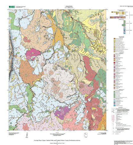
Attribute_Label: PTYPE
Attribute_Definition:
Geologic map unit label. Plain text is substituted for conventional geologic age symbols (TR for Triassic) shown on map.
Attribute_Domain_Values:
Enumerated_Domain:
Enumerated_Domain_Value: Ph
Enumerated_Domain_Value_Definition: Hermit Formation
Attribute_Domain_Values:
Enumerated_Domain:
Enumerated_Domain_Value: Pkf
Enumerated_Domain_Value_Definition:
Kaibab Formation, Fossil Mountain Member
Attribute_Domain_Values:
Enumerated_Domain:
Enumerated_Domain_Value: Pkh
Enumerated_Domain_Value_Definition: Kaibab Formation, Harrisburg Member
Attribute_Domain_Values:
Enumerated_Domain:
Enumerated_Domain_Value: Ptb
Enumerated_Domain_Value_Definition:
Toroweap Formation, Brady Canyon Member
Attribute_Domain_Values:
Enumerated_Domain:
Enumerated_Domain_Value: Pts
Enumerated_Domain_Value_Definition: Toroweap Formation, Seligman Member
Attribute_Domain_Values:
Enumerated_Domain:
Enumerated_Domain_Value: Ptw
Enumerated_Domain_Value_Definition: Toroweap Formation, Woods Ranch Member
Attribute_Domain_Values:
Enumerated_Domain:
Enumerated_Domain_Value: Qa1
Enumerated_Domain_Value_Definition: Young alluvial fan deposits
Attribute_Domain_Values:
Enumerated_Domain:
Enumerated_Domain_Value: Qa2
Enumerated_Domain_Value_Definition: Older alluvial fan deposits
Attribute_Domain_Values:
Enumerated_Domain:
Enumerated_Domain_Value: Qab
Enumerated_Domain_Value_Definition: Antelope Knoll Basalt, basalt flows
Attribute_Domain_Values:
Enumerated_Domain:
Enumerated_Domain_Value: Qaf
Enumerated_Domain_Value_Definition: Artificial fill and quarries
Attribute_Domain_Values:
Enumerated_Domain:
Enumerated_Domain_Value: Qap
Enumerated_Domain_Value_Definition:
Antelope Knoll Basalt, pyroclastic deposits
Attribute_Domain_Values:
Enumerated_Domain:
Enumerated_Domain_Value: Qb1
Enumerated_Domain_Value_Definition:
Quaternary basalts, undivided, basalt flows
Attribute_Domain_Values:
Enumerated_Domain:
Enumerated_Domain_Value: Qc
Enumerated_Domain_Value_Definition: Colluvial deposits
Attribute_Domain_Values:
Enumerated_Domain:
Enumerated_Domain_Value: Qcbb
Enumerated_Domain_Value_Definition:
Basalt of Craigs Knoll and Berry Knoll, basalt flows
Attribute_Domain_Values:
Enumerated_Domain:
Enumerated_Domain_Value: Qcbi
Enumerated_Domain_Value_Definition:
Basalt of Craigs Knoll and Berry Knoll, intrusive dike or neck
Attribute_Domain_Values:
Enumerated_Domain:
Enumerated_Domain_Value: Qcbp
Enumerated_Domain_Value_Definition:
Basalt of Craigs Knoll and Berry Knoll, pyroclastic deposits
Attribute_Domain_Values:
Enumerated_Domain:
Enumerated_Domain_Value: Qf
Enumerated_Domain_Value_Definition: Floodplain deposits
Attribute_Domain_Values:
Enumerated_Domain:
Enumerated_Domain_Value: Qg1
Enumerated_Domain_Value_Definition: Young terrace-gravel deposits
Attribute_Domain_Values:
Enumerated_Domain:
Enumerated_Domain_Value: Qg2
Enumerated_Domain_Value_Definition:
Intermediate-age terrace-gravel deposits
Attribute_Domain_Values:
Enumerated_Domain:
Enumerated_Domain_Value: Qg3
Enumerated_Domain_Value_Definition: Older terrace-gravel deposits
Attribute_Domain_Values:
Enumerated_Domain:
Enumerated_Domain_Value: Qgrb
Enumerated_Domain_Value_Definition: Basalt of Graham Ranch, basalt flows
Attribute_Domain_Values:
Enumerated_Domain:
Enumerated_Domain_Value: Qgri
Enumerated_Domain_Value_Definition:
Basalt of Graham Ranch, intrusive plug or dike
Attribute_Domain_Values:
Enumerated_Domain:
Enumerated_Domain_Value: Qgrp
Enumerated_Domain_Value_Definition:
Basalt of Graham Ranch, pyroclastic deposits
Attribute_Domain_Values:
Enumerated_Domain:
Enumerated_Domain_Value: Qhb
Enumerated_Domain_Value_Definition: Basalt of Hat knoll, basalt flows
Attribute_Domain_Values:
Enumerated_Domain:
Enumerated_Domain_Value: Qhi
Enumerated_Domain_Value_Definition:
Basalt of Hat knoll, intrusive dike or neck
Attribute_Domain_Values:
Enumerated_Domain:
Enumerated_Domain_Value: Qhp
Enumerated_Domain_Value_Definition:
Basalt of Hat knoll, pyroclastic deposits
Attribute_Domain_Values:
Enumerated_Domain:
Enumerated_Domain_Value: Qi
Enumerated_Domain_Value_Definition:
Quaternary basalts, undivided, basalt dike
Attribute_Domain_Values:
Enumerated_Domain:
Enumerated_Domain_Value: Ql
Enumerated_Domain_Value_Definition: Landslide deposits
Attribute_Domain_Values:
Enumerated_Domain:
Enumerated_Domain_Value: Qltb
Enumerated_Domain_Value_Definition: Basalt of Larimore Tank, basalt flows
Attribute_Domain_Values:
Enumerated_Domain:
Enumerated_Domain_Value: Qlti
Enumerated_Domain_Value_Definition:
Basalt of Larimore Tank, intrusive dike or neck
Attribute_Domain_Values:
Enumerated_Domain:
Enumerated_Domain_Value: Qltp
Enumerated_Domain_Value_Definition:
Basalt of Larimore Tank, pyroclastic deposits
Attribute_Domain_Values:
Enumerated_Domain:
Enumerated_Domain_Value: Qmb
Enumerated_Domain_Value_Definition: Basalt of Moriah Knoll, basalt flows
Attribute_Domain_Values:
Enumerated_Domain:
Enumerated_Domain_Value: Qmkb
Enumerated_Domain_Value_Definition: Basalt of Maryland Knoll, basalt flows
Attribute_Domain_Values:
Enumerated_Domain:
Enumerated_Domain_Value: Qmkp
Enumerated_Domain_Value_Definition:
Basalt of Maryland Knoll, pyroclastic deposits
Attribute_Domain_Values:
Enumerated_Domain:
Enumerated_Domain_Value: Qmp
Enumerated_Domain_Value_Definition:
Basalt of Moriah Knoll, pyroclastic deposits
Attribute_Domain_Values:
Enumerated_Domain:
Enumerated_Domain_Value: Qp1
Enumerated_Domain_Value_Definition:
Quaternary basalts, undivided, pyroclastic deposits
Attribute_Domain_Values:
Enumerated_Domain:
Enumerated_Domain_Value: Qs
Enumerated_Domain_Value_Definition: Stream-channel alluvium
Attribute_Domain_Values:
Enumerated_Domain:
Enumerated_Domain_Value: Qsb
Enumerated_Domain_Value_Definition: Basalt of Seven Knolls, basalt flows
Attribute_Domain_Values:
Enumerated_Domain:
Enumerated_Domain_Value: Qsi
Enumerated_Domain_Value_Definition:
Basalt of Seven Knolls, intrusive dike or neck
Attribute_Domain_Values:
Enumerated_Domain:
Enumerated_Domain_Value: Qskb
Enumerated_Domain_Value_Definition: Basalt of Spencer Knoll, basalt flows
Attribute_Domain_Values:
Enumerated_Domain:
Enumerated_Domain_Value: Qskp
Enumerated_Domain_Value_Definition:
Basalt of Spencer Knoll, pyroclastic deposits
Attribute_Domain_Values:
Enumerated_Domain:
Enumerated_Domain_Value: Qsp
Enumerated_Domain_Value_Definition:
Basalt of Seven Knolls, pyroclastic deposits
Attribute_Domain_Values:
Enumerated_Domain:
Enumerated_Domain_Value: Qt
Enumerated_Domain_Value_Definition: Talus deposits
Attribute_Domain_Values:
Enumerated_Domain:
Enumerated_Domain_Value: Qv
Enumerated_Domain_Value_Definition: Valley-fill deposits
Attribute_Domain_Values:
Enumerated_Domain:
Enumerated_Domain_Value: TRml
Enumerated_Domain_Value_Definition: Moenkopi Formation, lower red member
Attribute_Domain_Values:
Enumerated_Domain:
Enumerated_Domain_Value: TRmlt
Enumerated_Domain_Value_Definition:
Moenkopi Formation, lower red member and Timpoweap Member, undivided
Attribute_Domain_Values:
Enumerated_Domain:
Enumerated_Domain_Value: TRmm
Enumerated_Domain_Value_Definition: Moenkopi Formation, middle red member
Attribute_Domain_Values:
Enumerated_Domain:
Enumerated_Domain_Value: TRms
Enumerated_Domain_Value_Definition: Moenkopi Formation, Shnabkaib Member
Attribute_Domain_Values:
Enumerated_Domain:
Enumerated_Domain_Value: TRmt
Enumerated_Domain_Value_Definition: Moenkopi Formation, Timpoweap Member
Attribute_Domain_Values:
Enumerated_Domain:
Enumerated_Domain_Value: TRmv
Enumerated_Domain_Value_Definition:
Moenkopi Formation, Virgin Limestone Member
Detailed_Description:
Entity_Type:
Entity_Type_Label: CV_POLY.AAT
Entity_Type_Definition: Arc attribute table of coverage
Attribute:
Attribute_Label: LTYPE
Attribute_Definition:
Type of geologic or geographic feature denoted by a line in the database.
Attribute_Domain_Values:
Enumerated_Domain:
Enumerated_Domain_Value: contact_certain
Enumerated_Domain_Value_Definition:
Boundary between two mapped units that retains the original depositional or intrusive relationship. The contact has been observed or is closely constrained, so it is well located as described in Positional_Accuracy.
Attribute_Domain_Values:
Enumerated_Domain:
Enumerated_Domain_Value: landslide_scarp
Enumerated_Domain_Value_Definition:
Line demarcating the headwall of a landslide, also serving as a contact between a landslide unit (Ql) and the adjacent lithologic unit. This feature has been well-located as described in Positional_Accuracy.
Attribute_Domain_Values:
Enumerated_Domain:
Enumerated_Domain_Value: map_boundary
Enumerated_Domain_Value_Definition: Extent of mapped area.
Attribute_Domain_Values:
Enumerated_Domain:
Enumerated_Domain_Value: normal_flt_certain
Enumerated_Domain_Value_Definition:
Structural boundary between mapped units or structural discontinuity within a mapped unit that has experienced relative offset between the rock bodies on either side of the fault. The fault has been observed or is closely constrained, so it is well located as described in Positional_Accuracy.
Attribute_Domain_Values:
Enumerated_Domain:
Enumerated_Domain_Value: normal_flt_approx
Enumerated_Domain_Value_Definition:
Structural boundary between mapped units or structural discontinuity within a mapped unit that has experienced relative offset between the rock bodies on either side of the fault. The fault has not been observed, so it is not well located as described in Positional_Accuracy.
Attribute_Domain_Values:
Enumerated_Domain:
Enumerated_Domain_Value: normal_flt_concealed
Enumerated_Domain_Value_Definition:
Structural boundary between mapped units or structural discontinuity within a mapped unit that has experienced relative offset between the rock bodies on either side of the fault. The fault is obscured by overlying mapped units and it's trace is fairly apparent, so it is not well located as described in Positional_Accuracy.
Attribute_Domain_Values:
Enumerated_Domain:
Enumerated_Domain_Value: normal_flt_inferred
Enumerated_Domain_Value_Definition:
Structural boundary between mapped units or structural discontinuity within a mapped unit that has experienced relative offset between the rock bodies on either side of the fault. The fault is obscured by overlying mapped units and it's trace is uncertain, so it is not well located as described in Positional_Accuracy.
Attribute:
Attribute_Label: PTTYPE
Attribute_Definition: arc marker point type
Attribute_Domain_Values:
Enumerated_Domain:
Enumerated_Domain_Value: fault_ball_fill
Enumerated_Domain_Value_Definition:
Arcmarker attached to an arc describing the nature of displacement along a fault. Side of arc with bar and ball is the side with downthrown displacement.
Attribute_Domain_Values:
Enumerated_Domain:
Enumerated_Domain_Value: xx
Enumerated_Domain_Value_Definition:
No arcmarker is to be attached to an arc containing the xx value in the PTTYPE field.
Detailed_Description:
Entity_Type:
Entity_Type_Label: CV_FOLD.AAT
Entity_Type_Definition: Arc attribute table of coverage
Attribute:
Attribute_Label: LTYPE
Attribute_Definition:
Type of geologic or geographic feature denoted by a line in the database.
Attribute_Domain_Values:
Enumerated_Domain:
Enumerated_Domain_Value: anticline_certain_red
Enumerated_Domain_Value_Definition:
The surface trace of the axis of an anticline. The axis cannot be observed, but the location is constrained to be within about 5 mm at map scale or about 16 meters on the ground.
Attribute_Domain_Values:
Enumerated_Domain:
Enumerated_Domain_Value: anticline_concealed_red
Enumerated_Domain_Value_Definition:
The surface trace of the axis of an anticline. The axis cannot be observed, but the location is constrained to be within about 5 mm at map scale or about 16 meters on the ground. The axis is concealed by younger units but fairly apparent.
Attribute_Domain_Values:
Enumerated_Domain:
Enumerated_Domain_Value: basalt_flow_direction
Enumerated_Domain_Value_Definition:
Interpreted direction of lava flow as seen in a basalt flow unit. Arrowhead points in direction of flow.
Attribute_Domain_Values:
Enumerated_Domain:
Enumerated_Domain_Value: monocline_certain_red
Enumerated_Domain_Value_Definition:
The surface trace of the axis of a monocline. The axis cannot be observed, but the location is constrained to be within about 5 mm at map scale or about 16 meters on the ground.
Attribute_Domain_Values:
Enumerated_Domain:
Enumerated_Domain_Value: monocline_concealed_red
Enumerated_Domain_Value_Definition:
The surface trace of the axis of a monocline. The axis cannot be observed, but the location is constrained to be within about 5 mm at map scale or about 16 meters on the ground. The axis is concealed by younger units but fairly apparent.
Attribute_Domain_Values:
Enumerated_Domain:
Enumerated_Domain_Value: plunging_anticline_concealed_red
Enumerated_Domain_Value_Definition:
The surface trace of the axis of a plunging anticline. The axis cannot be observed, but the location is constrained to be within about 5 mm at map scale or about 16 meters on the ground. The axis is concealed by younger units but fairly apparent.
Attribute_Domain_Values:
Enumerated_Domain:
Enumerated_Domain_Value: plunging_anticline_red
Enumerated_Domain_Value_Definition:
The surface trace of the axis of a plunging anticline. The axis cannot be observed, but the location is constrained to be within about 5 mm at map scale or about 16 meters on the ground.
Attribute_Domain_Values:
Enumerated_Domain:
Enumerated_Domain_Value: plunging_syncline_concealed_red
Enumerated_Domain_Value_Definition:
The surface trace of the axis of a plunging syncline. The axis cannot be observed, but the location is constrained to be within about 5 mm at map scale or about 16 meters on the ground. The axis is concealed by younger units but fairly apparent.
Attribute_Domain_Values:
Enumerated_Domain:
Enumerated_Domain_Value: plunging_syncline_red
Enumerated_Domain_Value_Definition:
The surface trace of the axis of a plunging syncline. The axis cannot be observed, but the location is constrained to be within about 5 mm at map scale or about 16 meters on the ground.
Attribute_Domain_Values:
Enumerated_Domain:
Enumerated_Domain_Value: syncline_certain_red
Enumerated_Domain_Value_Definition:
The surface trace of the axis of a syncline. The axis cannot be observed, but the location is constrained to be within about 5 mm at map scale or about 16 meters on the ground.
Attribute_Domain_Values:
Enumerated_Domain:
Enumerated_Domain_Value: syncline_concealed_red
Enumerated_Domain_Value_Definition:
The surface trace of the axis of a syncline. The axis cannot be observed, but the location is constrained to be within about 5 mm at map scale or about 16 meters on the ground. The axis is concealed by younger units but fairly apparent.
Attribute_Domain_Values:
Enumerated_Domain:
Enumerated_Domain_Value: syncline_inferred_red
Enumerated_Domain_Value_Definition:
The surface trace of the axis of a syncline. The axis is obscured by overlying mapped units and it's trace is uncertain, but the location is constrained to be about 5 mm at map scale or within about 16 meters on the ground.
Attribute:
Attribute_Label: PTTYPE
Attribute_Definition: Arc marker point type
Attribute_Domain_Values:
Enumerated_Domain:
Enumerated_Domain_Value: anticline_red
Enumerated_Domain_Value_Definition:
Point element placed on line indicating the anticlinal nature of the particular fold axis.
Attribute_Domain_Values:
Enumerated_Domain:
Enumerated_Domain_Value: monocline_red
Enumerated_Domain_Value_Definition:
Point element placed on line indicating the monoclinal nature of the particular fold axis.
Attribute_Domain_Values:
Enumerated_Domain:
Enumerated_Domain_Value: syncline_red
Enumerated_Domain_Value_Definition:
Point element placed on line indicating the synclinal nature of the particular fold axis.
Attribute_Domain_Values:
Enumerated_Domain:
Enumerated_Domain_Value: xx
Enumerated_Domain_Value_Definition:
No arcmarker is to be attached to an arc containing the xx value in the PTTYPE field.
Detailed_Description:
Entity_Type:
Entity_Type_Label: CV_DIP.PAT
Entity_Type_Definition: Point attribute table of coverage
Attribute:
Attribute_Label: PTTYPE
Attribute_Definition:
The type of planar feature which was observed and the orientation of which was measured at this location.
Attribute_Domain_Values:
Enumerated_Domain:
Enumerated_Domain_Value: bedding
Enumerated_Domain_Value_Definition:
Originally horizontal sedimentary layers were observed and measured at this location.
Attribute_Domain_Values:
Enumerated_Domain:
Enumerated_Domain_Value: approx_bedding
Enumerated_Domain_Value_Definition:
Originally horizontal sedimentary layers were observed and estimated at this location.
Attribute_Domain_Values:
Enumerated_Domain:
Enumerated_Domain_Value: collapse_structure
Enumerated_Domain_Value_Definition:
Location of a circular collapse structure characterized by strata dipping inward toward a central point was observed. May reflect collapse of a deep-seated breccia pipe.
Attribute_Domain_Values:
Enumerated_Domain:
Enumerated_Domain_Value: sinkhole
Enumerated_Domain_Value_Definition:
Observed location of an enclosed depression or cave.
Attribute_Domain_Values:
Enumerated_Domain:
Enumerated_Domain_Value: vertical_joint
Enumerated_Domain_Value_Definition:
Orientation of vertical rock fracture without displacement was measured at this location.
Attribute_Domain_Values:
Enumerated_Domain:
Enumerated_Domain_Value: volcanic_vent
Enumerated_Domain_Value_Definition: Observed location of volcanic vent.
Attribute:
Attribute_Label: DIP
Attribute_Definition:
The inclination of planar structures measured in degrees down from horizontal.
Attribute_Domain_Values:
Range_Domain:
Range_Domain_Minimum: 0
Range_Domain_Maximum: 90
Attribute_Units_of_Measure: degrees
Attribute_Measurement_Resolution: 1
Attribute:
Attribute_Label: STRIKE
Attribute_Definition:
The orientation of a horizontal line in an inclined planar structure measured in degrees clockwise from north.
Attribute_Domain_Values:
Range_Domain:
Range_Domain_Minimum: 0
Range_Domain_Maximum: 359
Attribute_Units_of_Measure: degrees
Attribute_Measurement_Resolution: 1
Distribution_Information:
Distributor:
Contact_Information:
Contact_Organization_Primary:
Contact_Organization: U.S. Geological Survey Information Services
Contact_Address:
Address_Type: mailing address
Address: Box 25286 Denver Federal Center
City: Denver
State_or_Province: CO
Postal_Code: 80225
Country: USA
Contact_Voice_Telephone: 1-888-ASK-USGS
Contact_Electronic_Mail_Address: ask@usgs.gov
Resource_Description: USGS Miscellaneous Field Studies Map MF-2418
Distribution_Liability:
The U.S. Geological Survey (USGS) provides these geographic data "as is." The USGS makes no guarantee or warranty concerning the accuracy of information contained in the geographic data. The USGS further makes no warranties, either expressed or implied as to any other matter whatsoever, including, without limitation, the condition of the product, or its fitness for any particular purpose. The burden for determining fitness for use lies entirely with the user. Although these data have been processed successfully on computers at the USGS, no warranty, expressed or implied, is made by the USGS regarding the use of these data on any other system, nor does the fact of distribution constitute or imply any such warranty.
In no event shall the USGS have any liability whatsoever for payment of any consequential, incidental, indirect, special, or tort damages of any kind, including, but not limited to, any loss of profits arising out of use of or reliance on the geographic data or arising out of delivery, installation, operation, or support by USGS.
Standard_Order_Process:
Digital_Form:
Digital_Transfer_Information:
Format_Name: ARCE
Format_Version_Number: 8.1
Format_Information_Content:
Geologic units (cv_poly); folds, basalt flow lines (cv_ fold); point data including strike and dip, collapse features, sinkholes, and volcanic vents (cv_dip); and ancillary GIS files
File_Decompression_Technique: unzip
Transfer_Size: 12
Digital_Transfer_Option:
Online_Option:
Computer_Contact_Information:
Network_Address:
Fees: none
Metadata_Reference_Information:
Metadata_Date: 20160205
Metadata_Review_Date: 20020501
Metadata_Contact:
Contact_Information:
Contact_Person_Primary:
Contact_Person: Peter N Schweitzer
Contact_Organization: USGS Midwest Area
Contact_Position:
Collection manager, USGS Geoscience Data Clearinghouse, http://geo-nsdi.er.usgs.gov/
Contact_Address:
Address_Type: mailing address
Address:
Mail Stop 954
12201 Sunrise Valley Dr
City: Reston
State_or_Province: VA
Postal_Code: 20192-0002
Country: USA
Contact_Voice_Telephone: 703-648-6533
Contact_Facsimile_Telephone: 703-648-6252
Contact_Electronic_Mail_Address: pschweitzer@usgs.gov
Metadata_Standard_Name: Content Standard for Digital Geospatial Metadata
Metadata_Standard_Version: FGDC-STD-001-1998
Metadata_Access_Constraints: none
Metadata_Use_Constraints: none

This page is <https://geo-nsdi.er.usgs.gov/metadata/map-mf/2418/metadata.html>
Generated by mp version 2.9.48 on Tue Jul 03 20:05:19 2018