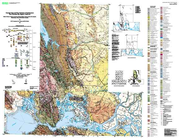
Attribute_Label: PTYPE
Attribute_Definition: Labels of geologic units and areas of water.
Attribute_Domain_Values:
Enumerated_Domain:
Enumerated_Domain_Value: Jb
Enumerated_Domain_Value_Definition: Coast Range ophiolite, basalt
Attribute_Domain_Values:
Enumerated_Domain:
Enumerated_Domain_Value: Jgb
Enumerated_Domain_Value_Definition: Coast Range ophiolite, gabbro
Attribute_Domain_Values:
Enumerated_Domain:
Enumerated_Domain_Value: Jk
Enumerated_Domain_Value_Definition: Knoxville Formation
Attribute_Domain_Values:
Enumerated_Domain:
Enumerated_Domain_Value: Jsv
Enumerated_Domain_Value_Definition: Keratophyre and quartz keratophyre tuff
Attribute_Domain_Values:
Enumerated_Domain:
Enumerated_Domain_Value: Jv
Enumerated_Domain_Value_Definition: Coast Range ophiolite, basalt and keratophyre
Attribute_Domain_Values:
Enumerated_Domain:
Enumerated_Domain_Value: KJfm
Enumerated_Domain_Value_Definition: Metagraywacke (Cretaceous(?) and Jurassic)
Attribute_Domain_Values:
Enumerated_Domain:
Enumerated_Domain_Value: KJgv
Enumerated_Domain_Value_Definition: Sandstone and shale (Early Cretaceous and Late Jurassic)
Attribute_Domain_Values:
Enumerated_Domain:
Enumerated_Domain_Value: KJgvm
Enumerated_Domain_Value_Definition: Sandstone- and shale-matrix melange
Attribute_Domain_Values:
Enumerated_Domain:
Enumerated_Domain_Value: KJu
Enumerated_Domain_Value_Definition:
Sandstone and shale (Early Cretaceous and Late Jurassic), sandstone member
Attribute_Domain_Values:
Enumerated_Domain:
Enumerated_Domain_Value: Kcs
Enumerated_Domain_Value_Definition: Massive sandstone (Cretaceous)
Attribute_Domain_Values:
Enumerated_Domain:
Enumerated_Domain_Value: Kf
Enumerated_Domain_Value_Definition: Funks Formation
Attribute_Domain_Values:
Enumerated_Domain:
Enumerated_Domain_Value: Kfo
Enumerated_Domain_Value_Definition: Forbes Formation
Attribute_Domain_Values:
Enumerated_Domain:
Enumerated_Domain_Value: Kfs
Enumerated_Domain_Value_Definition: Sandstone (Late Cretaceous)
Attribute_Domain_Values:
Enumerated_Domain:
Enumerated_Domain_Value: Kg
Enumerated_Domain_Value_Definition: Guinda Formation
Attribute_Domain_Values:
Enumerated_Domain:
Enumerated_Domain_Value: Kgvn
Enumerated_Domain_Value_Definition: Novato conglomerate
Attribute_Domain_Values:
Enumerated_Domain:
Enumerated_Domain_Value: Ks
Enumerated_Domain_Value_Definition: Sites Formation
Attribute_Domain_Values:
Enumerated_Domain:
Enumerated_Domain_Value: Ksh
Enumerated_Domain_Value_Definition: Sandstone and shale (Late Cretaceous), siliceous shale member
Attribute_Domain_Values:
Enumerated_Domain:
Enumerated_Domain_Value: Ku
Enumerated_Domain_Value_Definition: Undivided sandstone, siltstone, and shale (Late Cretaceous)
Attribute_Domain_Values:
Enumerated_Domain:
Enumerated_Domain_Value: Kuh
Enumerated_Domain_Value_Definition: Massive sandstone (Late Cretaceous)
Attribute_Domain_Values:
Enumerated_Domain:
Enumerated_Domain_Value: Kuhs
Enumerated_Domain_Value_Definition: Sandstone and shale (Late Cretaceous)
Attribute_Domain_Values:
Enumerated_Domain:
Enumerated_Domain_Value: Kus
Enumerated_Domain_Value_Definition: Sandstone, siltstone, and shale (Late Cretaceous)
Attribute_Domain_Values:
Enumerated_Domain:
Enumerated_Domain_Value: Kuss
Enumerated_Domain_Value_Definition: Sandstone and shale (Late Cretaceous), sandstone member
Attribute_Domain_Values:
Enumerated_Domain:
Enumerated_Domain_Value: Kv
Enumerated_Domain_Value_Definition: Venado Formation
Attribute_Domain_Values:
Enumerated_Domain:
Enumerated_Domain_Value: Ky
Enumerated_Domain_Value_Definition: Yolo Formation
Attribute_Domain_Values:
Enumerated_Domain:
Enumerated_Domain_Value: QTh
Enumerated_Domain_Value_Definition: Huichica Formation
Attribute_Domain_Values:
Enumerated_Domain:
Enumerated_Domain_Value: QThg
Enumerated_Domain_Value_Definition: Huichica and Glen Ellen Formations, undivided
Attribute_Domain_Values:
Enumerated_Domain:
Enumerated_Domain_Value: QTu
Enumerated_Domain_Value_Definition:
Sandstone, siltstone, and gravel (early Pleistocene and late Pliocene)
Attribute_Domain_Values:
Enumerated_Domain:
Enumerated_Domain_Value: Qa
Enumerated_Domain_Value_Definition: Alluvium (Holocene and late Pleistocene)
Attribute_Domain_Values:
Enumerated_Domain:
Enumerated_Domain_Value: Qds
Enumerated_Domain_Value_Definition: Dune sands (early Holocene and latest Pleistocene)
Attribute_Domain_Values:
Enumerated_Domain:
Enumerated_Domain_Value: Qf
Enumerated_Domain_Value_Definition: Alluvial fan deposits (Holocene and late Pleistocene)
Attribute_Domain_Values:
Enumerated_Domain:
Enumerated_Domain_Value: Qha
Enumerated_Domain_Value_Definition: Alluvium (Holocene)
Attribute_Domain_Values:
Enumerated_Domain:
Enumerated_Domain_Value: Qhay
Enumerated_Domain_Value_Definition: Younger alluvium (late Holocene)
Attribute_Domain_Values:
Enumerated_Domain:
Enumerated_Domain_Value: Qhb
Enumerated_Domain_Value_Definition: Basin deposits (Holocene)
Attribute_Domain_Values:
Enumerated_Domain:
Enumerated_Domain_Value: Qhbm
Enumerated_Domain_Value_Definition: Bay mud (Holocene)
Attribute_Domain_Values:
Enumerated_Domain:
Enumerated_Domain_Value: Qhc
Enumerated_Domain_Value_Definition: Stream channel deposits (Holocene)
Attribute_Domain_Values:
Enumerated_Domain:
Enumerated_Domain_Value: Qhdm
Enumerated_Domain_Value_Definition: Delta mud (Holocene)
Attribute_Domain_Values:
Enumerated_Domain:
Enumerated_Domain_Value: Qhf
Enumerated_Domain_Value_Definition: Alluvial fan deposits (Holocene)
Attribute_Domain_Values:
Enumerated_Domain:
Enumerated_Domain_Value: Qhfb
Enumerated_Domain_Value_Definition: Floodbasin deposits (Holocene)
Attribute_Domain_Values:
Enumerated_Domain:
Enumerated_Domain_Value: Qhff
Enumerated_Domain_Value_Definition: Fine-grained alluvial fan deposits (Holocene)
Attribute_Domain_Values:
Enumerated_Domain:
Enumerated_Domain_Value: Qhfp
Enumerated_Domain_Value_Definition: Floodplain deposits (Holocene)
Attribute_Domain_Values:
Enumerated_Domain:
Enumerated_Domain_Value: Qhl
Enumerated_Domain_Value_Definition: Natural levee deposits (Holocene)
Attribute_Domain_Values:
Enumerated_Domain:
Enumerated_Domain_Value: Qht
Enumerated_Domain_Value_Definition: Terrace deposits (Holocene)
Attribute_Domain_Values:
Enumerated_Domain:
Enumerated_Domain_Value: Qls
Enumerated_Domain_Value_Definition: Landslide deposits
Attribute_Domain_Values:
Enumerated_Domain:
Enumerated_Domain_Value: Qmz
Enumerated_Domain_Value_Definition: Montezuma Formation
Attribute_Domain_Values:
Enumerated_Domain:
Enumerated_Domain_Value: Qoa
Enumerated_Domain_Value_Definition: Alluvium (late and early Pleistocene)
Attribute_Domain_Values:
Enumerated_Domain:
Enumerated_Domain_Value: Qop
Enumerated_Domain_Value_Definition: Pediment deposits (late and early Pleistocene)
Attribute_Domain_Values:
Enumerated_Domain:
Enumerated_Domain_Value: Qpa
Enumerated_Domain_Value_Definition: Alluvium (late Pleistocene)
Attribute_Domain_Values:
Enumerated_Domain:
Enumerated_Domain_Value: Qpf
Enumerated_Domain_Value_Definition: Alluvial fan deposits (late Pleistocene)
Attribute_Domain_Values:
Enumerated_Domain:
Enumerated_Domain_Value: Qt
Enumerated_Domain_Value_Definition: Terrace deposits (Holocene and late Pleistocene)
Attribute_Domain_Values:
Enumerated_Domain:
Enumerated_Domain_Value: Tbh
Enumerated_Domain_Value_Definition: Briones Sandstone, Hambre shale member
Attribute_Domain_Values:
Enumerated_Domain:
Enumerated_Domain_Value: Tbl
Enumerated_Domain_Value_Definition: Briones Sandstone, lower member
Attribute_Domain_Values:
Enumerated_Domain:
Enumerated_Domain_Value: Tbr
Enumerated_Domain_Value_Definition: Briones Sandstone
Attribute_Domain_Values:
Enumerated_Domain:
Enumerated_Domain_Value: Tbu
Enumerated_Domain_Value_Definition: Briones Sandstone, upper member
Attribute_Domain_Values:
Enumerated_Domain:
Enumerated_Domain_Value: Tc
Enumerated_Domain_Value_Definition: Cierbo Sandstone
Attribute_Domain_Values:
Enumerated_Domain:
Enumerated_Domain_Value: Tcc
Enumerated_Domain_Value_Definition: Claremont Shale
Attribute_Domain_Values:
Enumerated_Domain:
Enumerated_Domain_Value: Tcgl
Enumerated_Domain_Value_Definition: Conglomerate (late Miocene)
Attribute_Domain_Values:
Enumerated_Domain:
Enumerated_Domain_Value: Td
Enumerated_Domain_Value_Definition: Domingene Sandstone
Attribute_Domain_Values:
Enumerated_Domain:
Enumerated_Domain_Value: Tdi
Enumerated_Domain_Value_Definition: Diatomite (middle to early Miocene)
Attribute_Domain_Values:
Enumerated_Domain:
Enumerated_Domain_Value: Tdm
Enumerated_Domain_Value_Definition: Donall Ranch volcanics of Youngman (1989), mafic member
Attribute_Domain_Values:
Enumerated_Domain:
Enumerated_Domain_Value: Tdr
Enumerated_Domain_Value_Definition: Donall Ranch volcanics of Youngman (1989), rhyolite member
Attribute_Domain_Values:
Enumerated_Domain:
Enumerated_Domain_Value: Teh
Enumerated_Domain_Value_Definition: Escobar Sandstone of Weaver (1953), basal shale member
Attribute_Domain_Values:
Enumerated_Domain:
Enumerated_Domain_Value: Tes
Enumerated_Domain_Value_Definition: Escobar Sandstone of Weaver (1953)
Attribute_Domain_Values:
Enumerated_Domain:
Enumerated_Domain_Value: Th
Enumerated_Domain_Value_Definition: Hambre Sandstone
Attribute_Domain_Values:
Enumerated_Domain:
Enumerated_Domain_Value: Tl
Enumerated_Domain_Value_Definition: Lawlor Tuff
Attribute_Domain_Values:
Enumerated_Domain:
Enumerated_Domain_Value: Tlj
Enumerated_Domain_Value_Definition: Las Juntas Shale of Weaver (1953)
Attribute_Domain_Values:
Enumerated_Domain:
Enumerated_Domain_Value: Tljl
Enumerated_Domain_Value_Definition: Las Juntas Shale of Weaver (1953), lower member
Attribute_Domain_Values:
Enumerated_Domain:
Enumerated_Domain_Value: Tlju
Enumerated_Domain_Value_Definition: Las Juntas Shale of Weaver (1953), upper member
Attribute_Domain_Values:
Enumerated_Domain:
Enumerated_Domain_Value: Tm
Enumerated_Domain_Value_Definition: Meganos Formation
Attribute_Domain_Values:
Enumerated_Domain:
Enumerated_Domain_Value: Tmk
Enumerated_Domain_Value_Definition: Markley Sandstone
Attribute_Domain_Values:
Enumerated_Domain:
Enumerated_Domain_Value: Tmkj
Enumerated_Domain_Value_Definition: Markley Sandstone, Jameson shale member
Attribute_Domain_Values:
Enumerated_Domain:
Enumerated_Domain_Value: Tmkl
Enumerated_Domain_Value_Definition: Markley Sandstone, lower member
Attribute_Domain_Values:
Enumerated_Domain:
Enumerated_Domain_Value: Tmku
Enumerated_Domain_Value_Definition: Markley Sandstone, upper member
Attribute_Domain_Values:
Enumerated_Domain:
Enumerated_Domain_Value: Tmr
Enumerated_Domain_Value_Definition: Muir Sandstone of Weaver (1953)
Attribute_Domain_Values:
Enumerated_Domain:
Enumerated_Domain_Value: Tmrl
Enumerated_Domain_Value_Definition: Muir Sandstone of Weaver (1953), lower member
Attribute_Domain_Values:
Enumerated_Domain:
Enumerated_Domain_Value: Tmru
Enumerated_Domain_Value_Definition: Muir Sandstone of Weaver (1953), upper member
Attribute_Domain_Values:
Enumerated_Domain:
Enumerated_Domain_Value: Tmz
Enumerated_Domain_Value_Definition: Martinez Formation
Attribute_Domain_Values:
Enumerated_Domain:
Enumerated_Domain_Value: Tn
Enumerated_Domain_Value_Definition: Neroly Sandstone
Attribute_Domain_Values:
Enumerated_Domain:
Enumerated_Domain_Value: Tnv
Enumerated_Domain_Value_Definition: Nortonville Shale Member of Kreyenhagen Formation
Attribute_Domain_Values:
Enumerated_Domain:
Enumerated_Domain_Value: Tnvl
Enumerated_Domain_Value_Definition: Nortonville Shale Member of Kreyenhagen Formation, lower member
Attribute_Domain_Values:
Enumerated_Domain:
Enumerated_Domain_Value: Tnvm
Enumerated_Domain_Value_Definition:
Nortonville Shale Member of Kreyenhagen Formation, middle member
Attribute_Domain_Values:
Enumerated_Domain:
Enumerated_Domain_Value: Tnvu
Enumerated_Domain_Value_Definition: Nortonville Shale Member of Kreyenhagen Formation, upper member
Attribute_Domain_Values:
Enumerated_Domain:
Enumerated_Domain_Value: Tor
Enumerated_Domain_Value_Definition: Orinda Formation
Attribute_Domain_Values:
Enumerated_Domain:
Enumerated_Domain_Value: Tpb
Enumerated_Domain_Value_Definition: Putnam Peak Basalt
Attribute_Domain_Values:
Enumerated_Domain:
Enumerated_Domain_Value: Tpc
Enumerated_Domain_Value_Definition: Petaluma Formation, claystone member
Attribute_Domain_Values:
Enumerated_Domain:
Enumerated_Domain_Value: Tps
Enumerated_Domain_Value_Definition: Petaluma Formation, mudrock, sandstone, and conglomerate member
Attribute_Domain_Values:
Enumerated_Domain:
Enumerated_Domain_Value: Tpt
Enumerated_Domain_Value_Definition: Pinole Tuff
Attribute_Domain_Values:
Enumerated_Domain:
Enumerated_Domain_Value: Tpth
Enumerated_Domain_Value_Definition: Tehama Formation
Attribute_Domain_Values:
Enumerated_Domain:
Enumerated_Domain_Value: Tptt
Enumerated_Domain_Value_Definition: Tehama Formation, Putah Tuff member
Attribute_Domain_Values:
Enumerated_Domain:
Enumerated_Domain_Value: Tpu
Enumerated_Domain_Value_Definition: Shale and sandstone (Pleistocene)
Attribute_Domain_Values:
Enumerated_Domain:
Enumerated_Domain_Value: Tpus
Enumerated_Domain_Value_Definition: Shale and sandstone (Pleistocene), basal sandstone member
Attribute_Domain_Values:
Enumerated_Domain:
Enumerated_Domain_Value: Tr
Enumerated_Domain_Value_Definition: Rodeo Shale
Attribute_Domain_Values:
Enumerated_Domain:
Enumerated_Domain_Value: Ts
Enumerated_Domain_Value_Definition: Sobrante Sandstone
Attribute_Domain_Values:
Enumerated_Domain:
Enumerated_Domain_Value: Tsa
Enumerated_Domain_Value_Definition: Sandstone (middle to early Miocene)
Attribute_Domain_Values:
Enumerated_Domain:
Enumerated_Domain_Value: Tsh
Enumerated_Domain_Value_Definition: Shale (Eocene)
Attribute_Domain_Values:
Enumerated_Domain:
Enumerated_Domain_Value: Tsr
Enumerated_Domain_Value_Definition: San Ramon Sandstone
Attribute_Domain_Values:
Enumerated_Domain:
Enumerated_Domain_Value: Tsv
Enumerated_Domain_Value_Definition: Sonoma Volcanics
Attribute_Domain_Values:
Enumerated_Domain:
Enumerated_Domain_Value: Tt
Enumerated_Domain_Value_Definition: Tice Shale
Attribute_Domain_Values:
Enumerated_Domain:
Enumerated_Domain_Value: Tut
Enumerated_Domain_Value_Definition: Tuffaceous sandstone (late Miocene)
Attribute_Domain_Values:
Enumerated_Domain:
Enumerated_Domain_Value: Tv
Enumerated_Domain_Value_Definition: Cierbo Sandstone, intercalated basalt
Attribute_Domain_Values:
Enumerated_Domain:
Enumerated_Domain_Value: Tvh
Enumerated_Domain_Value_Definition: Vine Hill Sandstone of Weaver (1953)
Attribute_Domain_Values:
Enumerated_Domain:
Enumerated_Domain_Value: Tvhl
Enumerated_Domain_Value_Definition: Vine Hill Sandstone of Weaver (1953), lower member
Attribute_Domain_Values:
Enumerated_Domain:
Enumerated_Domain_Value: Tvhu
Enumerated_Domain_Value_Definition: Vine Hill Sandstone of Weaver (1953), upper member
Attribute_Domain_Values:
Enumerated_Domain:
Enumerated_Domain_Value: ac
Enumerated_Domain_Value_Definition: Artificial channel deposits
Attribute_Domain_Values:
Enumerated_Domain:
Enumerated_Domain_Value: ads
Enumerated_Domain_Value_Definition: Dredge spoils
Attribute_Domain_Values:
Enumerated_Domain:
Enumerated_Domain_Value: af
Enumerated_Domain_Value_Definition: Artificial fill
Attribute_Domain_Values:
Enumerated_Domain:
Enumerated_Domain_Value: afbm
Enumerated_Domain_Value_Definition: Artificial fill over Bay mud
Attribute_Domain_Values:
Enumerated_Domain:
Enumerated_Domain_Value: alf
Enumerated_Domain_Value_Definition: Artificial levee fill
Attribute_Domain_Values:
Enumerated_Domain:
Enumerated_Domain_Value: fsr
Enumerated_Domain_Value_Definition: Melange
Attribute_Domain_Values:
Enumerated_Domain:
Enumerated_Domain_Value: sc
Enumerated_Domain_Value_Definition: Silica-carbonate rock
Attribute_Domain_Values:
Enumerated_Domain:
Enumerated_Domain_Value: sp
Enumerated_Domain_Value_Definition: Coast Range ophiolite, serpentinite