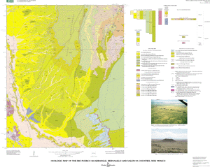
Abstract:
The Rio Puerco quadrangle is located southwest of Albuquerque in central
New Mexico and covers part of the western part of the Isleta Reservation.
The U.S. Geological Survey, the New Mexico Bureau of Geology and Mineral
Resources, and the University of New Mexico have conducted geologic
mapping on the Isleta Reservation and vicinity as part of the Middle Rio
Grande Basin Project. The map area contains surficial deposits, calcic
soils, fluvial deposits of the Rio Puerco, deposits of the Santa Fe Group,
and three volcanic fields. The area is characterized by predominantly
north-trending normal faults with generally down-to-the-east movement.
Post-Santa Fe Group deposits are composed of surficial deposits
(Pleistocene-Holocene) and fluvial deposits of the Rio Puerco
(Pleistocene-Holocene). The surficial deposits are divided into eolian,
alluvial, colluvial, and landslide deposits. The fluvial deposits of the
Rio Puerco consist of four terrace and present channel deposits.
The Santa Fe Group is divided into lower and upper parts. The lower part
of the Santa Fe Group is exposed near the southwestern corner of the study
area where deposits consist of reddish-brown mudstone and sandstone
correlated to the Popotosa Formation (Unit 1) of Lozinsky and Tedford
(1991). They interpreted deposition of the unit in a basin-floor playa
setting. The Popotosa Formation is in fault contact to the east with
deposits of the upper Santa Fe Group. The upper Santa Fe Group is derived
from major tributary fluvial systems (ancestral Rio Puerco Puerco and
possibly the Rio San Jose drainages) draining the adjacent Colorado
Plateau and Sierra Nacimiento and correlated to parts of Kelley's (1977)
Ceja Formation of the Santa Fe Group and equivalent to Machette's (1978)
Sierra Ladrones Formation, Connell's Arroyo Ojito Formation (Connell and
others, 1999, and Maldonado's lithofacies of the Isleta Reservation
(Maldonado and Atencio,1998a, b). The group also locally includes a fine-
grained unit (lower Pleistocene) referred to here as the sand, silt, and
clay of Chavez Grant (Qsc). The Ceja Formation of the Santa Fe Group as
defined here is divided into the following units in descending
stratigraphic order: (1) upper sand and gravel unit (upper Pliocene), (2)
middle silt, sand, and clay unit (upper Pliocene), and (3) lower sand and
gravel unit (Pliocene).
The three volcanic fields in the map area are: (1) basalt of Cat Hills,
dated at 98-110 ka and composed of seven lava flows and four cinder cones;
the flows overlie calcic soils that overlie the upper sand and gravel unit
of the Ceja Formation; (2) lava flow of Cat Mesa, dated at about 3 Ma and
interfingers with the upper part of the Ceja Formation; (3) diabase of
Mohinas Mountain, dated at 8.3 Ma (Baldridge and others, 1987) and
intrudes the Popotosa Formation.
Numerous high-angle faults cut the area but are mostly buried. The faults
generally trend north but deviate to the northwest and northeast. The
major normal faults are the Cat Mesa and Mohinas Mountain faults.
Purpose:
To conduct new geologic mapping and to provide geologic information for
land-use decisions and water management, as part of the U.S. Geological
Survey's Middle Rio Grande Project. Mapping of this quadrangle will also
be used to compile parts of the Isleta 1:50,000-scale geologic map.
Supplemental_Information:
Compilation scale 1:24000
Geology mapped 1998-1999.
Geospatial datafiles and other files included in this data set:
rp_geol: geologic units and "shared" fault/contacts
rp_line: faults not "shared" in rp-geol coverage
rp_pnt: bedding and sample locations
base map: riopuerco.tif and riopuerco.tfw
ArcInfo shadeset: ctr269.shd
Theme:
Theme_Keyword_Thesaurus: USGS Thesaurus
Theme_Keyword: geologic maps
Theme_Keyword: bedrock geologic units
Theme_Keyword: geologic structure
Theme_Keyword: tectonic processes
Theme_Keyword: sedimentary rocks
Theme_Keyword: geomorphology
Theme_Keyword: hydrology
Theme_Keyword: volcanic rocks
Theme_Keyword: geospatial datasets
Theme_Keyword: geology
Theme:
Theme_Keyword_Thesaurus: American Geological Institute (AGI) Glossary of Geology
Theme_Keyword: Geologic map
Theme_Keyword: Santa Fe Group
Theme_Keyword: High-angle normal faults
Theme_Keyword: Rio Grande Rift
Theme_Keyword: Tertiary basin fill
Theme_Keyword: Geomorphology
Theme_Keyword: Hydrology
Theme_Keyword: Calcic soil
Theme_Keyword: Volcanic rocks
Theme_Keyword: Basaltic rocks
Theme_Keyword: Surficial deposits
Theme:
Theme_Keyword_Thesaurus: ISO 19115 Topic Categories
Theme_Keyword: geoscientificInformation
Place:
Place_Keyword_Thesaurus: Board of Geographic Names
Place_Keyword: USA
Place_Keyword: New Mexico
Place_Keyword: Bernalillo County
Place_Keyword: Valencia County
Place_Keyword: Isleta Reservation
Place_Keyword: Belen Basin
Place_Keyword: Rio Grande
Place_Keyword: Rio Puerco
Place_Keyword: Albuquerque
Place_Keyword: Mohinas Mountain
Place_Keyword: Hidden Mountain
Place_Keyword: Cat Hills
Place_Keyword: Cat Mesa
Place_Keyword: Pueblo of Isleta
Place:
Place_Keyword_Thesaurus: Augmented FIPS 10-4 and FIPS 6-4
Place_Keyword: f35001 = Bernalillo
Place_Keyword: f35061 = Valencia
Stratum:
Stratum_Keyword_Thesaurus: None
Stratum_Keyword: Quaternary surficial deposits
Stratum_Keyword: Calcic soils
Stratum_Keyword: Volcanic rocks
None. Acknowledgment of the U.S. Geological Survey would be appreciated in
products derived from these data.