Online Links:
| Value | Definition |
|---|---|
| Pe | Esplanade Sandstone |
| Ph | Hermit Formation |
| Pkf | Kaibab Formation, Fossil Mountain member |
| Pkh | Kaibab Formation, Harrisburg member |
| Pkl | Pakoon Limestone |
| Ps | Supai Group, undivided |
| Ptb | Toroweap Formation, Brady Canyon member |
| Pts | Toroweap Formation, Seligman member |
| Ptw | Toroweap Formation, Woods Ranch member |
| Qa1 | Young alluvial fan deposits |
| Qa2 | Young intermediate age alluvial fan deposits |
| Qa3 | Old intermediate age alluvial fan deposits |
| Qa4 | Old alluvial fan deposits |
| Qa5 | Oldest alluvial fan deposits |
| Qaf | Artificial deposits |
| Qc | Colluvial deposits |
| Qf | Floodplain or ponded deposits |
| Qg1 | Young terrace gravel deposits |
| Qg2 | Young intermediate terrace gravel deposits |
| Qg3 | Old intermediate terrace gravel deposits |
| Qg4 | Old terrace gravel deposits |
| Ql | Landslide deposits |
| Qs | Stream-channel alluvium |
| Qt | Talus deposits |
| Qv | Valley-fill deposits |
| QTa | Tertiary and Quaternary alluvium |
| Ti | Pigeon Canyon, Intrusive dikes |
| Tpb | Shivwits Plateau, Basalt flows |
| Tpi | Shivwits Plateau, Intrusive rocks |
| Tpp | Shivwits Plateau, Pyroclastic deposts |
| Tsb | Poverty Mountain, Basalt flows |
| Tsi | Poverty Mountain, Intrusive dike |
| Tsp | Poverty Mountain, Pyroclastic deposits |
| TRml | Moenkopi Formation, Lower red member |
| TRmm | Moenkopi Formation, Middle red member |
| TRms | Moenkopi Formation, Shnabkaib Member |
| TRmt | Moenkopi Formation, Timpoweap Member |
| TRmv | Moenkopi Formation, Virgin Limestone Member |
| xx | Placeholder for non-geologic feature |
| Value | Definition |
|---|---|
| contact_approx | Boundary between two mapped units that retains the original depositional or intrusive relationship. The contact is approximate, so it is not as well located as described in Positional_Accuracy. |
| contact_certain | Boundary between two mapped units that retains the original depositional or intrusive relationship. The contact has been observed or is closely constrained, so it is well located as described in Positional_Accuracy. |
| high_angle_flt_approx | Structural boundary between mapped units or structural discontinuity within a mapped unit that has experienced relative offset between the rock bodies on either side of the fault. The fault has been observed or is closely constrained, so it is not well located as described in Positional_Accuracy. |
| high_angle_flt_certain | Structural boundary between mapped units or structural discontinuity within a mapped unit that has experienced relative offset between the rock bodies on either side of the fault. The fault has been observed or is closely constrained, so it is well located as described in Positional_Accuracy. |
| high_angle_flt_concealed | Structural boundary between mapped units or structural discontinuity within a mapped unit that has experienced relative offset between the rock bodies on either side of the fault. The fault is obscured by overlying mapped units, so it is not well-located as described in Positional_Accuracy, but the location is constrained to be within 3 mm at mapscale or within about 95 meters on the ground. |
| landslide_scarp | Line demarcating the headwall of a landslide, also serving as a contact between a landslide unit (Ql) and the adjacent lithologic unit. This feature has been well-located as described in Positional_Accuracy. |
| map_boundary | Edge of the mapped area. Used primarily to bound polygons at the edge of the map database. The location of the boundary is well located as described in Positional_Accuracy. |
| Value | Definition |
|---|---|
| fault_ball_fill | Arcmarker attached to an arc describing the nature of displacement along a fault. Side of arc with bar and ball is the side with downthrown displacement. |
| xx | No arcmarker is to be attached to an arc containing the xx value in the PTTYPE field. |
| Value | Definition |
|---|---|
| anticline_certain_red | The surface trace of the axis of an anticline. The axis has not been observed, but the location is constrained to be within about 3 mm at map scale or within about 72 meters on the ground. |
| anticline_concealed_red | The surface trace of the axis of an anticline. The axis has not been observed, but the location is constrained to be within about 3 mm at map scale or within about 72 meters on the ground. The axis is concealed by younger units unaffected by earlier folding. |
| basalt_flow_direction | Interpreted direction of flow as seen in a basalt flow unit. Arrowhead points in direction of flow. |
| monocline_certain_red | The surface trace of the axis of a monocline. The axis has not been observed, but the location is constrained to be within about 3 mm at map scale or within about 72 meters on the ground. |
| plunging_anticline_red | The surface trace of the axis of a plunging anticline. The axis has not been observed, but the location is constrained to be within about 5 mm at map scale or within about 160 meters on the ground. |
| plunging_syncline_red | The surface trace of the axis of a plunging syncline. The axis has not been observed, but the location is constrained to be within about 5 mm at map scale or within about 160 meters on the ground. |
| syncline_certain_red | The surface trace of the axis of a syncline. The axis has not been observed, but the location is constrained to be within about 3 mm at map scale or within about 72 meters on the ground. |
| syncline_concealed_red | The surface trace of the axis of a syncline. The axis has not been observed, but the location is constrained to be within about 3 mm at map scale or within about 72 meters on the ground. The axis is concealed by younger units unaffected by earlier folding. |
| Value | Definition |
|---|---|
| anticline_red | Point element placed on line indicating the anticlinal nature of the particular fold axis. Defined only in conjunction with an LTYPE of anticline_certain. |
| monocline_red | Point element placed on line indicating the monoclinal nature of the particular fold axis. Defined only in conjunction with an LTYPE of monocline_concealed or monocline_certain. |
| syncline_red | Point element placed on line indicating the synclinal nature of the particular fold axis. Defined only in conjunction with an LTYPE of syncline_certain or syncline_concealed. |
| xx | No point element is to be placed on an arc with PTTYPE defined as xx. |
| Value | Definition |
|---|---|
| bedding | Originally horizontal sedimentary layers were observed and measured at this point. |
| collapse_structure | A probable breccia pipe collapse structure was observed at this location. |
| sinkhole | Observed location of an enclosed depression or cave. |
| vertical_joint | The orientation of vertical rock fractures without displacement was measured at this point. |
| volcanic_vent | Observed location of a volcanic vent or cinder cone center. |
| Range of values | |
|---|---|
| Minimum: | 0 |
| Maximum: | 90 |
| Units: | degrees |
| Resolution: | 1 |
| Range of values | |
|---|---|
| Minimum: | 0 |
| Maximum: | 359 |
| Units: | degrees |
| Resolution: | 1 |
This digital database was prepared by Jessica Wellmeyer, Michelle Harr, and Sue Priest at the U.S. Geological Survey.
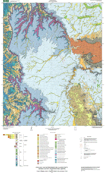
The geologic map of Hidden Hills and vicinity covers part of the Arizona Strip north of Grand Canyon and several large tributary canyons that make up the western part of Arizona's Grand Canyon. The map is part of a cooperative U.S. Geological Survey, National Park Service, and Bureau of Land Management project to provide geologic information for areas within the newly established Grand Canyon-Parashant National Monument. This map fills in one of the remaining areas where uniform quality geologic mapping was needed. The geologic information will be useful for future resource management studies for federal, state, and private agencies.
Are there legal restrictions on access or use of the data?Access_Constraints: None
Use_Constraints:Uses of this digital geologic map should not violate the spatial resolution of the map area (1:31,680) even though the digital data form removes the constraint of scale on a paper map. The accuracy inherent in map scale is also present in digital format. At a scale larger than 1:31,680, higher resolution data is not available and will not yield greater real detail.
Any hardcopies utilizing these datasets shall clearly indicate their source. If users modify the data in any way they are obligated to describe the types of modifications they have performed. User specifically agrees not to misrepresent these datasets, nor to imply that changes they made were approved by the U.S. Geological Survey.
The U.S. Geological Survey (USGS) provides these geographic data "as is." The USGS makes no guarantee or warranty concerning the accuracy of information contained in the geographic data. The USGS further makes no warranties, either expressed or implied as to any other matter whatsoever, including, without limitation, the condition of the product, or its fitness for any particular purpose. The burden for determining fitness for use lies entirely with the user. Although these data have been processed successfully on computers at the USGS, no warranty, expressed or implied, is made by the USGS regarding the use of these data on any other system, nor does the fact of distribution constitute or imply any such warranty.
In no event shall the USGS have any liability whatsoever for payment of any consequential, incidental, indirect, special, or tort damages of any kind, including, but not limited to, any loss of profits arising out of use of or reliance on the geographic data or arising out of delivery, installation, operation, or support by USGS.
| Data format: | Geologic units and structural features, with scanned topographic contour map image, symbols, shades, and markers used to produce the printed map in format ARCE (version 8.1) Size: 23 |
|---|---|
| Network links: |
http://pubs.usgs.gov/mf/2002/2387/hhdb.zip |