Seismic Landslide Hazard for the City of Berkeley, California

Metadata also available as - [Questions & Answers] - [Parseable text] - [XML]

Metadata:

Identification_Information:
Citation:
Citation_Information:
Originator: Miles, S.B.
Originator: Keefer, D.K.
Publication_Date: 2001
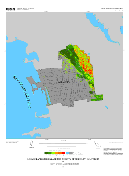
Title: Seismic Landslide Hazard for the City of Berkeley, California
Geospatial_Data_Presentation_Form: Map
Series_Information:
Series_Name: U.S. Geological Survey Miscellaneous Field Studies Map
Issue_Identification: MF-2378
Publication_Information:
Publication_Place: Menlo Park, CA
Publisher: U.S. Geological Survey
Online_Linkage: http://pubs.usgs.gov/mf/2001/2378/
Description:
Abstract:
This map describes the possible hazard from earthquake-induced landslides for the city of Berkeley, CA. The hazard depicted by this map was modeled for a scenario corresponding to an M=7.1 earthquake on the Hayward, CA fault. This scenario magnitude is associated with complete rupture of the northern and southern segments of the Hayward fault, an event that has an estimated return period of about 500 years. The modeled hazard also corresponds to completely saturated ground-water conditions resulting from an extreme storm event or series of storm events. This combination of earthquake and ground-water scenarios represents a particularly severe state of hazard for earthquake- induced landslides. For dry ground-water conditions, overall hazard will be less, while relative patterns of hazard are likely to change.
Purpose:
The map is intended as a tool for regional planning. Any site- specific planning or analysis should be undertaken with the assistance of a qualified geotechnical engineer. This hazard map should not be used as a substitute to the State of California Seismic Hazard Zones map for the same area. (See California Department of Conservation, Division of Mines and Geology, 1999). As previously noted for maps of this type by Wieczorek and others (1985), this map should not be used as a basis to determine the absolute risk from seismically triggered landslides at any locality, as the sole justification for zoning or rezoning any parcel, for detailed design of any lifeline, for site- specific hazard-reduction planning, or for setting or modifying insurance rates.
Time_Period_of_Content:
Time_Period_Information:
Range_of_Dates/Times:
Beginning_Date: 1969
Ending_Date: 2000
Currentness_Reference:
The data used in the construction of this map were published by the USGS between 1969 and 1999. Transformation of this data was performed in 2000. The date of construction should be considered with respect to state of the practice when using this map.
Status:
Progress: Complete
Maintenance_and_Update_Frequency: Irregular
Spatial_Domain:
Bounding_Coordinates:
West_Bounding_Coordinate: -122.3
East_Bounding_Coordinate: -122.2
North_Bounding_Coordinate: 37.9
South_Bounding_Coordinate: 37.8
Keywords:
Theme:
Theme_Keyword_Thesaurus: USGS Thesaurus
Theme_Keyword: landslides
Theme_Keyword: landslide susceptibility assessment
Theme_Keyword: hazards
Theme_Keyword: earthquakes
Theme_Keyword: geospatial datasets
Theme:
Theme_Keyword_Thesaurus: ISO 19115 Topic Categories
Theme_Keyword: geoscientificInformation
Place:
Place_Keyword_Thesaurus: none
Place_Keyword: California
Place_Keyword: Berkeley
Place_Keyword: USA
Place:
Place_Keyword_Thesaurus: Augmented FIPS 10-4 and FIPS 6-4
Place_Keyword: f06001 = Alameda
Access_Constraints: None
Use_Constraints:
Users should acknowledge the authors and the U.S. Geological Survey if data used to derive products. Users should check with western publications prior to use to check for revisions or updates.
The map is intended as a tool for regional planning. Any site- specific planning or analysis should be undertaken with the assistance of a qualified geotechnical engineer. This hazard map should not be used as a substitute to the State of California Seismic Hazard Zones map for the same area. (See California Department of Conservation, Division of Mines and Geology, 1999). As previously noted for maps of this type by Wieczorek and others ( 1985), this map should not be used as a basis to determine the absolute risk from seismically triggered landslides at any locality, as the sole justification for zoning or rezoning and parcel, for detailed design of any lifeline, for site-specific hazard-reduction planning, or for setting or modifying insurance rates.
Point_of_Contact:
Contact_Information:
Contact_Person_Primary:
Contact_Person: Scott B Miles
Contact_Organization: U.S. Geological Survey
Contact_Address:
Address_Type: mailing address
Address:
Mail Stop 977
345 Middlefield Rd
City: Menlo Park
State_or_Province: CA
Postal_Code: 94025
Country: USA
Contact_Voice_Telephone: 650-329-
Contact_Facsimile_Telephone: 650-329-5163
Contact_Electronic_Mail_Address: smiles@usgs.gov
Browse_Graphic:
Browse_Graphic_File_Name: http://pubs.usgs.gov/mf/2001/2378/images/mf2378.gif
Browse_Graphic_File_Description:
Reduced-size image of the map sheet, 450x614 pixels, 32-bit RGB true color, 20k bytes.
Browse_Graphic_File_Type: GIF
Data_Set_Credit:
The authors would like to thank Russ Graymer, Steve Walter and Scott Graham for technical assistance during the map construction. We would also like to thank Ray Wilson and Kevin Schmidt for reviews of the map and manuscript.
Native_Data_Set_Environment:
The databases in this MF were compiled in ARC/INFO, a commercial Geographic Information System (Environmental Systems Research Institute, Redlands, California). The files are in GRID (ARC/INFO raster data) format. Coverages are stored in uncompressed ARC export format (ARC/INFO version 7.x). ARC/INFO export files (files with the .e00 extension) can be converted into ARC/INFO coverages in ARC/INFO (see below) and can be read by some other Geographic Information Systems. The digital compilation was done in Arc/Info version 7.1.
Data_Quality_Information:
Attribute_Accuracy:
Attribute_Accuracy_Report:
The attribute contained in this database is the result of mathematical modeling. User should refer to accompanying narrative to assess if attribute is appropriate for their use.
Logical_Consistency_Report:
No additional checks for topological consistency were performed on this data set.
Completeness_Report:
This map product is entirely derived from existing digital map data sources.
Lineage:
Source_Information:
Source_Citation:
Citation_Information:
Originator: U.S. Geological Survey
Publication_Date: 2000
Title:
San Francisco Bay Area 24K Digital Elevation Model Database (10 meters)
Geospatial_Data_Presentation_Form: raster digital data
Publication_Information:
Publication_Place: Menlo Park, CA
Publisher: U.S. Geological Survey
Online_Linkage: http://bard.wr.usgs.gov/
Source_Scale_Denominator: 24000
Type_of_Source_Media: Online
Source_Time_Period_of_Content:
Time_Period_Information:
Single_Date/Time:
Calendar_Date: 2000
Source_Currentness_Reference: date data were obtained for the project
Source_Citation_Abbreviation: DEM
Source_Contribution: Digital elevation values
Source_Information:
Source_Citation:
Citation_Information:
Originator: Graymer, R.W.
Originator: Jones, D.L.
Originator: Brabb, E.E.
Publication_Date: 1996
Title:
Preliminary geologic map emphasizing bedrock formations in Alameda County, California: A digital database
Geospatial_Data_Presentation_Form: Map
Series_Information:
Series_Name: U.S. Geological Survey Open-File Report
Issue_Identification: 96-252
Publication_Information:
Publication_Place: Menlo Park, CA
Publisher: U.S. Geological Survey
Online_Linkage: http://pubs.usgs.gov/of/1996/of96-252/
Source_Scale_Denominator: 50000
Type_of_Source_Media: online
Source_Time_Period_of_Content:
Time_Period_Information:
Range_of_Dates/Times:
Beginning_Date: 1978
Ending_Date: 1996
Source_Currentness_Reference: 1996
Source_Citation_Abbreviation: Geology
Source_Contribution:
Geologic formation boundaries and identities Fault trace
Process_Step:
Process_Description:
The map construction process is described in detail within accompaning narrative.
In brief, slope was calculated from the DEM. Geologic units were assigned strength parameters. Distance to each pixel in grid was calculated from fault trace. Arias intensity was calculated using equation of (Wilson, 1993) and the calculated distances. Soil strength and slope were used to calculate static factor of safety for saturated conditions. Factor of saftey and slope was used to calculate critical acceleration. Critical acceleration and Arias intensity were combined using the equation of Jibson et al. (1998)
Process_Date: 2000
Process_Step:
Process_Description: Creation of original metadata record
Process_Date: 20090709
Process_Contact:
Contact_Information:
Contact_Organization_Primary:
Contact_Organization: U.S. Geological Survey
Contact_Person: Peg Rawson
Contact_Address:
Address_Type: mailing address
Address: 507 National Center
City: Reston
State_or_Province: VA
Postal_Code: 20192
Country: USA
Contact_Voice_Telephone: 703-648-4183
Contact_Electronic_Mail_Address: mrawson@usgs.gov
Spatial_Data_Organization_Information:
Direct_Spatial_Reference_Method: Raster
Raster_Object_Information:
Raster_Object_Type: Grid Cell
Row_Count: 662
Column_Count: 801
Spatial_Reference_Information:
Horizontal_Coordinate_System_Definition:
Planar:
Grid_Coordinate_System:
Grid_Coordinate_System_Name: Universal Transverse Mercator
Universal_Transverse_Mercator:
UTM_Zone_Number: 10
Transverse_Mercator:
Scale_Factor_at_Central_Meridian: 1
Longitude_of_Central_Meridian: -123
Latitude_of_Projection_Origin: 37.7
False_Easting: 0
False_Northing: 0
Planar_Coordinate_Information:
Planar_Coordinate_Encoding_Method: coordinate pair
Coordinate_Representation:
Abscissa_Resolution: 1
Ordinate_Resolution: 1
Planar_Distance_Units: Meters
Geodetic_Model:
Horizontal_Datum_Name: North American Datum of 1927
Ellipsoid_Name: Clarke 1866
Semi-major_Axis: 6378206.4
Denominator_of_Flattening_Ratio: 294.98
Entity_and_Attribute_Information:
Detailed_Description:
Entity_Type:
Entity_Type_Label: Landslide hazard grid cell
Entity_Type_Definition: Any elements in hazard map data
Entity_Type_Definition_Source: Author
Attribute:
Attribute_Label: Value
Attribute_Definition:
Value refers to color within Arc/Info plot code table. 1 indicates the least hazard, 6 indicates the highest relative hazard.
Attribute_Definition_Source: Author
Attribute_Domain_Values:
Range_Domain:
Range_Domain_Minimum: 1
Range_Domain_Maximum: 6
Attribute_Domain_Values:
Enumerated_Domain:
Enumerated_Domain_Value: 7
Enumerated_Domain_Value_Definition: unanalyzed
Attribute_Domain_Values:
Enumerated_Domain:
Enumerated_Domain_Value: 8
Enumerated_Domain_Value_Definition: water
Attribute:
Attribute_Label: Count
Attribute_Definition: Arc/Info assigned count of number of cells of a given Value
Attribute_Definition_Source: Author
Distribution_Information:
Distributor:
Contact_Information:
Contact_Organization_Primary:
Contact_Organization: Earth Science Information Center, U.S. Geological Survey
Contact_Address:
Address_Type: mailing address
Address: 507 National Center
City: Reston
State_or_Province: VA
Postal_Code: 20192
Country: USA
Contact_Voice_Telephone: 1-888-ASK-USGS (1-888-275-8747)
Resource_Description: USGS Miscellaneous Field Studies Map MF-2378
Distribution_Liability:
Although these data have been processed successfully on a computer system at the U.S. Geological Survey, no warranty expressed or implied is made by the U.S. Geological Survey regarding the utility of the data on any other system, nor shall the act of distribution constitute any such warranty. No responsibility is assumed by the U.S. Geological Survey in the use of these data. Any use of trade, product, or firm names is for descriptive purposes only and does not imply endorsement by the U.S. Government.
Standard_Order_Process:
Digital_Form:
Digital_Transfer_Information:
Format_Name: ARCE
Format_Version_Number: 8.0
Format_Information_Content:
Grid with ancillary vector coverages depicting base map information.
File_Decompression_Technique: unzip
Transfer_Size: 0.5
Digital_Transfer_Option:
Online_Option:
Computer_Contact_Information:
Network_Address:
Fees: none
Metadata_Reference_Information:
Metadata_Date: 20160205
Metadata_Contact:
Contact_Information:
Contact_Person_Primary:
Contact_Person: Peter N Schweitzer
Contact_Organization: USGS Midwest Area
Contact_Position:
Collection manager, USGS Geoscience Data Clearinghouse, http://geo-nsdi.er.usgs.gov/
Contact_Address:
Address_Type: mailing address
Address:
Mail Stop 954
12201 Sunrise Valley Dr
City: Reston
State_or_Province: VA
Postal_Code: 20192-0002
Country: USA
Contact_Voice_Telephone: 703-648-6533
Contact_Facsimile_Telephone: 703-648-6252
Contact_Electronic_Mail_Address: pschweitzer@usgs.gov
Metadata_Standard_Name: Content Standard for Digital Geospatial Metadata
Metadata_Standard_Version: FGDC-STD-001-1998

This page is <https://geo-nsdi.er.usgs.gov/metadata/map-mf/2378/metadata.html>
Generated by mp version 2.9.48 on Tue Jul 03 20:05:11 2018