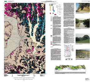
Geologic map of the Saint Joseph area, Missouri and Kansas

Metadata also available as - [Outline] - [Parseable text] - [XML]

Frequently anticipated questions:


What does this data set describe?

Title: Geologic map of the Saint Joseph area, Missouri and Kansas
Abstract:
The map shows the surficial geology, including alluvium, loess, till, terrace alluvium, eolian silt, glaciofluvial gravel, and bedrock outcrops in the area around St. Joseph, Missouri.
  1. How might this data set be cited?
    Langer, William H., Smith, David, Brady, Lawrence L., Melick, Roger A., and Daniel H. Knepper, Jr., 2002, Geologic map of the Saint Joseph area, Missouri and Kansas: U.S. Geological Survey Miscellaneous Field Studies Map MF-2374, U.S. Geological Survey, Denver, Colorado.

    Online Links:

  2. What geographic area does the data set cover?
    West_Bounding_Coordinate: -95.00
    East_Bounding_Coordinate: -94.625
    North_Bounding_Coordinate: 40.00
    South_Bounding_Coordinate: 39.5
  3. What does it look like?
    http://pubs.usgs.gov/mf/2002/mf-2374/MF-2374.gif (GIF)
    Reduced-size image of the entire map sheet, 288x263 pixels, 46k bytes.
    http://pubs.usgs.gov/mf/2002/mf-2374/mf-2374.pdf (PDF)
    Printable representation of the map layout, 5.3 megabytes.
  4. Does the data set describe conditions during a particular time period?
    Calendar_Date: 2002
    Currentness_Reference:
    publication date
  5. What is the general form of this data set?
    Geospatial_Data_Presentation_Form: map
  6. How does the data set represent geographic features?
    1. How are geographic features stored in the data set?
      This is a vector data set.
    2. What coordinate system is used to represent geographic features?
      Horizontal positions are specified in geographic coordinates, that is, latitude and longitude. Latitudes are given to the nearest 0.0005. Longitudes are given to the nearest 0.0005. Latitude and longitude values are specified in decimal degrees. The horizontal datum used is North American Datum of 1927.
      The ellipsoid used is Clarke 1866.
      The semi-major axis of the ellipsoid used is 6378206.4.
      The flattening of the ellipsoid used is 1/294.98.
  7. How does the data set describe geographic features?
    surficial.dbf
    Surficial geologic units
    UNITCODE
    Symbol that could be used for labeling the geologic unit (string of width 6)
    ValueDefinition
    coColluvium
    QalAlluvium
    QatTerrace alluvium
    QlLoess
    Ql/tAreas of loess where till is at depths of about 4 m or less below the land surface.
    QlrBedrock outcrops and near surface bedrock covered with thin loess.
    QpgFluvial gravel
    QpsEolian silt
    QtTill
    Qt2Mustard Till, described under "Weathered Till" in the map legend
    QtrBedrock outcrops and near surface bedrock covered with thin till.
    QuarryExcavated area of a quarry

Who produced the data set?

  1. Who are the originators of the data set? (may include formal authors, digital compilers, and editors)
    • William H. Langer
    • David Smith
    • Lawrence L. Brady
    • Roger A. Melick
    • Daniel H. Knepper, Jr.
  2. Who also contributed to the data set?
    This map was prepared as a collaborative effort with the Missouri Division of Geology and Land Survey, the Kansas Geological Survey, and the Nebraska Conservation and Survey Division.
    William H. Langer and David Smith mapped the geology in 1993 and 1994. The authors' team digitized the map and prepared the ARC/INFO database. Database structure checked by Nancy Shock, and she prepared the files for importing into Adobe Illustrator. Norma J. Maes prepared the Adobe Illustrator map layout, which was used for the on-demand paper map and gif and pdf plot and browse graphic files. F.C. Brunstein edited the publication and prepared some of the files for the Illustrator layout, and prepared the metadata file, which was checked by Nancy Shock.
  3. To whom should users address questions about the data?
    William H Langer
    U.S. Geological Survey Central Region Minerals Team
    Research Geologist
    Mail Stop 973
    P.O. Box 25046
    Denver, CO
    USA

    303-236-1249 (voice)
    303-236-3200 (FAX)
    blanger@usgs.gov

Why was the data set created?

To describe the surficial geology in the area around St. Joseph, Missouri.

How was the data set created?

  1. From what previous works were the data drawn?
    Langer and Smith map (source 1 of 1)
    Langer, William H., and Smith, David, (unpublished), unpublished map of Saint Joseph area.

    Type_of_Source_Media: hand drawn inked greenline mylar
    Source_Scale_Denominator: 50000
    Source_Contribution: New and compiled geologic mapping
  2. How were the data generated, processed, and modified?
    Date: 1993 (process 1 of 3)
    Map units and preliminary contacts between units were identified using stereoscopic pairs of high altitude, false-color infrared, aerial photographs. Contacts were drawn on twelve USGS 7½ minute topographic maps, and were checked in the field. U.S. Department of Agriculture Soil Survey maps at a scale of 1:62,500 for Buchanan County (Tillman and Deardorff, 1915), Andrew County (Sweet and Jordan, 1925), Platte County (Sweet and others, 1911), and Doniphan County (Knobel and others, 1927) were used to provide a general overview of the soils of the area. A U.S. Geological Survey map at a scale of 1:24,000 showing the geohydrology of Doniphan County, Kansas (Bayne, 1973); soil surveys at a scale of 1:24,000 for Buchanan County (Lockridge, 1989), Andrew County (Davis, 1990), and Platte County (Preston, 1985); and a soil survey at a scale of 1:20,000 for Doniphan County (Sallee, 1980) were used to corroborate map contacts and field observations.
    Field-checked contacts were transferred from the twelve 7½ minute topographic maps to scale-stable 1:24,000-scale base maps that subsequently were digitized. The twelve digital files were merged into one single map coverage.
    Date: 2000 (process 2 of 3)
    The original inked geology was digitized in ARC/INFO. The lines and polygon attributes were checked against the original geology and corrected as neccessary. Shadeset and lineset attributes were added in ARC. The digital database was quality checked against original materials, and the database structure was checked. The ARC/INFO files were imported into Illustrator 8.0, and the map layout was completed in Illustrator. The Illustrator layout was used to produce the GIF and PDF browse graphic files and the plot file, as well as the on-demand paper map. The illustrator layout was proofed before the GIF and PDF files were made and before the map was placed in the map-on- demand system.
    Date: 05-Oct-2001 (process 3 of 3)
    Creation of original metadata record Person who carried out this activity:
    William H Langer
    U.S. Geological Survey Central Region Minerals Team
    Research Geologist
    Mail Stop 973
    P.O. Box 25046
    Denver, CO
    USA

    303-236-1249 (voice)
    303-236-3200 (FAX)
    blanger@usgs.gov
  3. What similar or related data should the user be aware of?

How reliable are the data; what problems remain in the data set?

  1. How well have the observations been checked?
  2. How accurate are the geographic locations?
  3. How accurate are the heights or depths?
  4. Where are the gaps in the data? What is missing?
  5. How consistent are the relationships among the observations, including topology?
    Visual proof of computer plot against orginal inked geology on greenline mylar.

How can someone get a copy of the data set?

Are there legal restrictions on access or use of the data?
Access_Constraints: none
Use_Constraints:
This database is not meant to be used or displayed at scales larger or smaller than the range encompassing 1:50,000 to 1:63,360.
  1. Who distributes the data set? (Distributor 1 of 1)
    U.S. Geological Survey, Central Publications Group
    Database Administrator
    MS 902, USGS, Denver Federal Center
    Denver, CO
    USA

    (303) 236-7684 (voice)
    nshock@usgs.gov
  2. What's the catalog number I need to order this data set? USGS Miscellaneous Field Studies Map MF-2374
  3. What legal disclaimers am I supposed to read?
    Although these data have been used by the USGS and have been successfully imported into data base programs, no warranty, expressed or implied, is made by the USGS as to how successfully or accurately the data can be imported into any specific application software running on any specific hardware platform. The fact of distribution shall not constitute any such warranty, and no responsibility is assumed by the USGS in connection therewith.
  4. How can I download or order the data?

Who wrote the metadata?

Dates:
Last modified: 13-Jun-2016
Metadata author:
Peter N Schweitzer
USGS Midwest Area
Collection manager, USGS Geoscience Data Clearinghouse, http://geo-nsdi.er.usgs.gov/
Mail Stop 954
12201 Sunrise Valley Dr
Reston, VA
USA

703-648-6533 (voice)
703-648-6252 (FAX)
pschweitzer@usgs.gov
Metadata standard:
Content Standard for Digital Geospatial Metadata (FGDC-STD-001-1998)

This page is <https://geo-nsdi.er.usgs.gov/metadata/map-mf/2374/metadata.faq.html>
Generated by mp version 2.9.48 on Tue Jul 03 20:05:10 2018