Geologic map of the Eagle quadrangle, Eagle County, Colorado

Metadata also available as - [Outline] - [Parseable text] - [XML]

Frequently anticipated questions:


What does this data set describe?

Title: Geologic map of the Eagle quadrangle, Eagle County, Colorado
Abstract:
The Eagle quadrangle covers an area that straddles the Eagle River and Interstate 70 (I-70) and it includes the town of Eagle, Colo., which is located in the southwestern part of the quadrangle, just south of I-70 and the Eagle River, about 37 km west of Vail, Colo. The map area is part of the I-70 urban corridor, which is experiencing rapid and escalating urban growth. Geologic mapping along this corridor is needed for ongoing land-use planning. A variety of rocks and deposits characterize the map area and areas nearby. Sedimentary rocks present in the map area range in age from Pennsylvanian rocks, which were deposited in the ancestral Eagle basin during the formation of the ancestral Rocky Mountains, to Late Cretaceous rocks that were deposited just prior to the formation of the present Rocky Mountains. The Pennsylvanian rocks in the map area include a thick sequence of evaporitic rocks (Eagle Valley Evaporite). These evaporitic rocks are commonly complexly folded throughout the southern part of the quadrangle where they are exposed. In general, in the central and northern parts of the quadrangle, the sedimentary rocks overlying the evaporite dip gently to moderately northward. Consequently, the youngest sedimentary rocks (Late Cretaceous rocks) are exposed dipping gently to the north in the northern part of the quadrangle; landslide complexes are widespread along the northerly dipping, dip slopes in shaly rocks of the Cretaceous sequence in the northeastern part of the map area. During the Early Miocene, basaltic volcanism formed extensive basaltic flows that mantled the previously deformed and eroded sedimentary rocks. Erosional remnants of the basaltic flows are preserved in the southeastern, west-central, and north-central parts of the map area. Some of these basaltic flows are faulted and downdropped in a manner that suggests they were downdropped in areas where large volumes of the underlying evaporitic rocks were removed from the subsurface, beneath the basaltic rocks, by dissolution or flowage of the evaporite in the subsurface. Quaternary and late Tertiary(?) surficial deposits in the map area consist mainly of Quaternary alluvium and colluvium, late and middle Pleistocene terrace gravels of the Eagle River, Miocene(?) gravel remnants of the ancestral Eagle River and its tributaries, and Pleistocene to recent mass movement deposits that include landslides and debris flows. Potential geologic hazards in the map area include landslides, debris flows, rockfalls, local flooding, ground subsidence, and expansive and corrosive soils.
Supplemental_Information:
Map political location: Eagle County, Colorado Compilation scale: 1:24,000 Geology mapped in 1997.

GEOSPATIAL DATA FILES INCLUDED IN THIS DATA SET:
eaglepy: polygon coverage containing geologic unit contacts and labels.
eagleln: arc coverage containing fold axes and other line entities.
eaglept: point coverage containing bedding attitude measurements and other point entities.
eaglepit: polygon coverage containing gravel pits.
  1. How might this data set be cited?
    Lidke, David J., 2002, Geologic map of the Eagle quadrangle, Eagle County, Colorado: U.S. Geological Survey Miscellaneous Field Studies Map MF-2361, U.S. Geological Survey, Denver, Colorado.

    Online Links:

  2. What geographic area does the data set cover?
    West_Bounding_Coordinate: -106.875
    East_Bounding_Coordinate: -106.75
    North_Bounding_Coordinate: 39.75
    South_Bounding_Coordinate: 39.625
  3. What does it look like?
    http://pubs.usgs.gov/mf/2002/mf-2361/mf-2361_map.pdf (PDF)
    Printable representation of map layout, 3.9M bytes.
    http://pubs.usgs.gov/mf/2002/mf-2361/mf-2361.gif (GIF)
    Reduced-size image of the entire map sheet, 250x212 pixels, 32-bit RGB true color, 29k bytes.
  4. Does the data set describe conditions during a particular time period?
    Calendar_Date: 2002
    Currentness_Reference:
    publication date
  5. What is the general form of this data set?
    Geospatial_Data_Presentation_Form: map
  6. How does the data set represent geographic features?
    1. How are geographic features stored in the data set?
      This is a Vector data set.
    2. What coordinate system is used to represent geographic features?
      The map projection used is Polyconic.
      Projection parameters:
      Longitude_of_Central_Meridian: -106.8125
      Latitude_of_Projection_Origin: 39.625
      False_Easting: 0.000
      False_Northing: 0.000
      Planar coordinates are encoded using coordinate pair
      Abscissae (x-coordinates) are specified to the nearest 20
      Ordinates (y-coordinates) are specified to the nearest 20
      Planar coordinates are specified in METERS
      The horizontal datum used is North American Datum of 1927.
      The ellipsoid used is Clarke 1866.
      The semi-major axis of the ellipsoid used is 6378206.4.
      The flattening of the ellipsoid used is 1/294.98.
  7. How does the data set describe geographic features?
    Entity_and_Attribute_Overview:
    ---------------------------------------------------------------
    COVERAGE NAME: eagleln
    ---------------------------------------------------------------
    
    USER-DEFINED ITEMS IN EAGLELN.AAT:
    ------------------------------------
    
    ATTRIBUTE NAME: DESCRIPTION
    DATABASE ITEM STRUCTURE: 80,80,C,0
    DESCRIPTION: type of line entity
    ITEM VALUES FOR 'DESCRIPTION':
    (see table below)
    
    ATTRIBUTE NAME: SYMBOL
    DATABASE ITEM STRUCTURE: 3,3,I,0
    DESCRIPTION: line symbol used to draw line entity (geol_sfo.lin and geoscamp1.lin)
    ITEM VALUES FOR 'SYMBOL':
    (see table below)
    
    Relationship of items 'DESCRIPTION' and 'SYMBOL':
    
    DESCRIPTION                                SYMBOL
    ---------------------------------------------------
    anticline, certain                           60
    anticline, concealed                         63
    anticline, inferred                          62
    cross-section A-A'                          210
    cross-section B-B'                          210
    plunging anticline, certain                  60
    plunging anticline, concealed                63
    plunging syncline, certain                   92
    plunging syncline, concealed                 95
    pressure (buckle) ridge in landslide         85
    syncline, certain                            92
    syncline, concealed                          95
    syncline, inferred                           94
    
    ---------------------------------------------------------------
    COVERAGE NAME: eaglept
    ---------------------------------------------------------------
    
    USER-DEFINED ITEMS IN EAGLEPT.PAT:
    ------------------------------------
    
    ATTRIBUTE NAME: DESCRIPTION
    DATABASE ITEM STRUCTURE: 80,80,C,0
    DESCRIPTION: type of point entity
    ITEM VALUES FOR 'DESCRIPTION':
    (see table below)
    
    ATTRIBUTE NAME: AZIMUTH
    DATABASE ITEM STRUCTURE: 3,3,I,0
    DESCRIPTION: compass orientation of point measurement, if applicable
    ITEM VALUES FOR 'AZIMUTH':
    integer value in the range 0-359
    
    
    ATTRIBUTE NAME: INCLINATION
    DATABASE ITEM STRUCTURE: 5,5,C,0
    DESCRIPTION: inclination from vertical of point measurement, if applicable
    ITEM VALUES FOR 'INCLINATION':
    values in the range 0-89, or blank where inclination unknown
    
    
    ATTRIBUTE NAME: SYMBOLCODE
    DATABASE ITEM STRUCTURE: 3,3,I,0
    DESCRIPTION: markersymbol used to draw point entity (geoscamp1.mrk, geoscamp2.mrk, usgs.mrk, oilgas.mrk)
    ITEM VALUES FOR 'SYMBOLCODE':
    (see table below)
    
    Relationship of items 'DESCRIPTION' and 'SYMBOLCODE':
    
    DESCRIPTION                                 SYMBOLCODE
    -------------------------------------------------------
    approximate strike and dip of inclined beds         14
    strike and dip of contorted beds                     9
    ash deposit                                        241
    dry hole                                           101
    horizontal bedding                                   1
    minor anticline                                    413
    strike and dip of inclined beds                      2


    ---------------------------------------------------------------
    COVERAGE NAME: eaglepy
    ---------------------------------------------------------------
    
    USER-DEFINED ITEMS IN EAGLEPY.PAT:
    ------------------------------------
    
    ATTRIBUTE NAME: DESCRIPTION
    DATABASE ITEM STRUCTURE: 80,80,C,0
    DESCRIPTION: description of geologic unit
    ITEM VALUES FOR 'DESCRIPTION':
    (see table below)
    
    ATTRIBUTE NAME: LABEL
    DATABASE ITEM STRUCTURE: 6,6,C,0
    DESCRIPTION: geologic unit label
    ITEM VALUES FOR 'LABEL':
    (see table below)
    
    ATTRIBUTE NAME: SYMBOL
    DATABASE ITEM STRUCTURE: 4,4,I,0
    DESCRIPTION: shade symbol used to color geologic unit polygon (color524.shd)
    ITEM VALUES FOR 'SYMBOL':
    (see table below)
    
    Relationship of items 'DESCRIPTION', 'LABEL', and 'SYMBOL':
    
    LABEL   SYMBOL    DESCRIPTION
    --------------------------------------------
    (none)     313    water
    &e         241    Eagle Valley Formation
    &ee        243    Eagle Valley Evaporite
    @Ps        372    State Bridge Formation
    @c         510    Chinle Formation
    Je         365    Entrada Sandstone
    Jm         427    Morrison Formation
    Kb         379    Benton Shale
    Kd         454    Dakota Sandstone
    Kn         482    Niobrara Formation
    Ku         391    Niobrara Formation and Benton Shale, undivided
    P&m        320    main body of Maroon Formation
    Pms        316    Schoolhouse Member of Maroon Formation
    QTbr        22    basalt rubble
    Qa           6    stream-channel and flood-plain deposits along Brush Creek
    Qac         25    undivided alluvium and colluvium
    Qalc         7    stream-channel and flood-plain deposits along Eagle River
    Qc          12    colluvium, undifferentiated
    Qcd         12    colluvium of Dakota Sandstone
    Qcg         12    gravelly colluvium
    Qcv         12    basalt-rich colluvium
    Qdo         34    older debris-flow deposits
    Qdu         55    undifferentiated debris-flow and landslide deposits of Eby Creek
    Qdy         15    younger debris-flow deposits
    Qfo         33    older fan alluvium and colluvium
    Qfy         32    younger fan alluvium and colluvium
    Qls         16    landslide deposits
    Qlsb        16    landslide derived from Benton Shale
    Qlsn        16    landslide derived from Niobrara Formation
    Qlsv        16    landslide debris of volcanic rocks
    Qp         451    pediment deposit
    Qtm         20    intermediate terrace alluvium
    Qto         13    older terrace alluvium
    Qtpl        19    lower oldest terrace alluvium
    Qtpm        19    middle oldest terrace alluvium
    Qtpu        19    upper oldest terrace alluvium
    Qty         23    younger terrace alluvium
    Tb         130    basaltic flows
    Tbv         39    basaltic flows, volcaniclastic rocks, and conglomerate
    Tg          51    Tertiary gravel
    af           8    artificial fill
    
    In the LABEL item, the & and @ refer to the Pennsylvanian and Triassic
    symbols, respectively.
    
    USER-DEFINED ITEMS IN EAGLEPY.AAT:
    ------------------------------------
    
    ATTRIBUTE NAME: DESCRIPTION
    DATABASE ITEM STRUCTURE: 80,80,C,0
    DESCRIPTION: type of line entity
    ITEM VALUES FOR 'DESCRIPTION':
    (see table below)
    
    ATTRIBUTE NAME: SYMBOL
    DATABASE ITEM STRUCTURE: 3,3,I,0
    DESCRIPTION: line symbol used to draw line entity (geol_sfo.lin and geoscamp1.lin)
    ITEM VALUES FOR 'SYMBOL':
    (see table below)
    
    Relationship of items 'DESCRIPTION' and 'SYMBOL':
    
    DESCRIPTION                                    SYMBOL
    -----------------------------------------------------
    contact, certain                                    1
    contact, approximately located                      2
    contact, concealed                                  4
    high-angle fault, certain                         173
    high-angle fault, concealed                       176
    high-angle fault, inferred                        217
    high-angle fault, certain, with bar and ball       50
    high-angle fault, concealed, with bar and ball    184
    high-angle fault, inferred, with bar and ball     183
    landslide scarp, certain                           15
    map boundary                                       50
    marker bed, certain                                50
    marker bed, approximately located                  51
    water boundary                         0
    
    ---------------------------------------------------------------
    COVERAGE NAME: eaglepit
    ---------------------------------------------------------------
    
    USER-DEFINED ITEMS IN EAGLEPIT.PAT:
    ------------------------------------
    
    ATTRIBUTE NAME: DESCRIPTION
    DATABASE ITEM STRUCTURE: 80,80,C,0
    DESCRIPTION: description of polygon
    ITEM VALUES FOR 'DESCRIPTION': gravel pit
    
    ATTRIBUTE NAME: SYMBOL
    DATABASE ITEM STRUCTURE: 4,4,I,0
    DESCRIPTION: shade symbol used to color polygon (color524.shd)
    ITEM VALUES FOR 'SYMBOL': 0
    
    
    USER-DEFINED ITEMS IN EAGLEPY.AAT:
    ------------------------------------
    
    ATTRIBUTE NAME: DESCRIPTION
    DATABASE ITEM STRUCTURE: 80,80,C,0
    DESCRIPTION: type of line entity
    ITEM VALUES FOR 'DESCRIPTION': gravel pit boundary
    
    ATTRIBUTE NAME: SYMBOL
    DATABASE ITEM STRUCTURE: 3,3,I,0
    DESCRIPTION: line symbol used to draw line entity (geol_sfo.lin and geoscamp1.lin)
    ITEM VALUES FOR 'SYMBOL': 1
    
    Entity_and_Attribute_Detail_Citation: none

Who produced the data set?

  1. Who are the originators of the data set? (may include formal authors, digital compilers, and editors)
    • David J. Lidke
  2. Who also contributed to the data set?
  3. To whom should users address questions about the data?
    David J. Lidke
    U.S. Geological Survey
    MS 913, Box 25046 DFC
    Denver, CO

    303-236-1286 (voice)
    dlidke@usgs.gov

Why was the data set created?

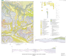
This map was funded by the National Cooperative Geologic Program as part of the geologic mapping studies conducted along the I-70 urban corridor. This corridor is experiencing rapid urban growth and geologic mapping is needed to aid in land-use planning in order to address, avoid, and mitigate known and potential geologic hazards.

How was the data set created?

  1. From what previous works were the data drawn?
  2. How were the data generated, processed, and modified?
    Date: 1999 (process 1 of 9)
    Polygons, lines, and points representing geologic features and data points were digitized from scale-stable compilation materials using the GSMCAD public domain program (USGS Open-File Report 96-007).
    Date: 1999 (process 2 of 9)
    The map data were exported to ARC/INFO using the GSMCAD export function to create ARC generate ASCII files. The ASCII files were then imported into ArcInfo using the GENERATE routine, and polygon topology built.
    Date: 1999 (process 3 of 9)
    The gsmdraw.aml program was used in ARC to produce a graphics file of the colored map. In addition an explanation sheet was produced that includes a correlation of map units diagram, a list of map unit names and corresponding symbols, and an explanation of graphical map symbols.
    Date: 2000 (process 4 of 9)
    Text map unit descriptors were added to the .AAT and .PAT database files for each coverage.
    Date: 2000 (process 5 of 9)
    Draft check plots of the geologic map and explanation were created and submitted for peer review. Geologists reviewed the plots for conformity with U.S. Geological Survey editorial standards and stratigraphic nomenclature. Revisions were made to the geospatial database as needed.
    Date: 2001 (process 6 of 9)
    The database files, metadata, and check plots were edited by the U.S. Geological Survey Central Publications Group, and revisions made to the geospatial database as needed.
    Date: 2001 (process 7 of 9)
    The geospatial database files and metadata were quality checked for completeness and consistency.
    Date: 2002 (process 8 of 9)
    Final preparation of the geospatial database for distribution, and preparation of map-on-demand files and metadata.
    Date: 22-Feb-2002 (process 9 of 9)
    Creation of original metadata record Person who carried out this activity:
    David J. Lidke
    U.S. Geological Survey
    MS 913, Box 25046, DFC
    Denver, CO

    303-236-1286 (voice)
    dlidke@usgs.gov
  3. What similar or related data should the user be aware of?

How reliable are the data; what problems remain in the data set?

  1. How well have the observations been checked?
    Data were entered and checked by the geologist that made the field observations. The attributes of this geospatial data set consist of text identifiers and numeric codes that indicate the identity of the geologic unit or type of geologic feature, and determine how each feature is colored or symbolized. To check attribute accuracy, a color check plot was visually compared to the geologist's original compilation. Discrepancies between the digital geospatial dataset and the original analog compilation were corrected as needed. Machine-created listings of unique attribute values were used to identify spelling errors or other inconsistencies, and corrections were made as needed. This map has been thoroughly reviewed for conformity with U.S. Geological Survey editorial standards and stratigraphic nomenclature.
  2. How accurate are the geographic locations?
    Lines were primarily positioned by photointerpretation of 1:24,000-scale color aerial photographs using a PG-2 photogrammetric plotter that rectified the position and transferred it to a base map. Lines were digitized from the base map using a digitizer tablet with resolution of 0.001 inch. Most digitized positions on the map are estimated to have about 20-m horizontal accuracy.
  3. How accurate are the heights or depths?
  4. Where are the gaps in the data? What is missing?
    Data are complete: no features that could be accurately represented at the compilation scale of 1:24,000 were eliminated or generalized. The smallest area represented is approximately 20 square meters. All geospatial database elements are attributed.
  5. How consistent are the relationships among the observations, including topology?
    Map elements were visually checked for overshoots, undershoots, duplicate features, polygon closure, and other errors by the author and by the GIS technician(s) that created the digital database. Automated (ArcInfo) routines were also used to check the databases for polygon label errors, line or point attribution errors, sliver polygons, dangling arcs, intersection errors, and projection information. Check plots of the map were reviewed by at least two other geologists for consistency with basic geologic principles and general conformity to U.S. Geological Survey mapping standards.

How can someone get a copy of the data set?

Are there legal restrictions on access or use of the data?
Access_Constraints: none
Use_Constraints:
none. Acknowledgment of the U.S. Geological Survey would be appreciated in products derived from these data.
  1. Who distributes the data set? (Distributor 1 of 1)
    U.S. Geological Survey
    Central Publications Group
    Denver, CO

  2. What's the catalog number I need to order this data set? USGS Miscellaneous Field Studies Map MF-2361
  3. What legal disclaimers am I supposed to read?
    Although this digital spatial data has been subjected to rigorous review and is substantially complete, it is released on the condition that neither the U.S. Geological Survey nor the United States Government may be held liable for any damages resulting from its authorized or unauthorized use.
  4. How can I download or order the data?

Who wrote the metadata?

Dates:
Last modified: 10-Jun-2016
Last Reviewed: 01-Mar-2002
Metadata author:
Peter N Schweitzer
USGS Midwest Area
Collection manager, USGS Geoscience Data Clearinghouse, http://geo-nsdi.er.usgs.gov/
Mail Stop 954
12201 Sunrise Valley Dr
Reston, VA
USA

703-648-6533 (voice)
703-648-6252 (FAX)
pschweitzer@usgs.gov
Metadata standard:
Content Standard for Digital Geospatial Metadata (FGDC-STD-001-1998)

This page is <https://geo-nsdi.er.usgs.gov/metadata/map-mf/2361/metadata.faq.html>
Generated by mp version 2.9.48 on Tue Jul 03 20:05:06 2018