Citation:
Citation_Information:
Originator: Hudson, Mark R.
Originator: Murray, Kyle E.
Originator: Pezzutti, Deborah
Publication_Date: 2001
Title:
Geologic map of the Jasper quadrangle, Newton and Boone
Counties, Arkansas
Edition: 1.0
Geospatial_Data_Presentation_Form: Map
Series_Information:
Series_Name: Miscellaneous Field Sudies Map
Issue_Identification: MF-2356
Publication_Information:
Publication_Place: Denver, Colorado
Publisher: U.S. Geological Survey
Online_Linkage: http://pubs.usgs.gov/mf/2001/mf-2356/
Description:
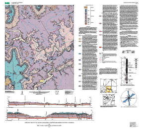
Abstract:
This digital geologic map compilation presents new polygon
(i.e., geologic map unit contacts), line (i.e., fault, fold
axis, and structure contour), and point (i.e., structural
attitude, contact elevations) vector data for the Jasper 7 1/2'
quadrangle in northern Arkansas. The map database, which is at
1:24,000-scale resolution, provides geologic coverage of an
area of current hydrogeologic, tectonic, and stratigraphic
interest. The Jasper quadrangle is located in northern Newton
and southern Boone Counties about 20 km south of the town of
Harrison. The map area is underlain by sedimentary rocks of
Ordovician, Mississippian, and Pennsylvanian age that were
mildly deformed by a series of normal and strike-slip faults and
folds. The area is representative of the stratigraphic and
structural setting of the southern Ozark Dome. The Jasper
quadrangle map provides new geologic information for better
understanding groundwater flow paths in and adjacent to the
Buffalo River watershed.
Purpose:
To provide a digital geologic map database of the quadrangle
that improves understanding of the regional geologic framework
and its influence on the regional groundwater flow system.
Supplemental_Information:
The current map database incorporates geologic data
from: (1) early geologic mapping (1906) by Purdue and Miser and
(2) more recent field mapping (1995-1998) by M.R. Hudson.
Buffalo National River, under the auspices of the National
Park Service, occupies the central part of the map area.
FILES INCLUDED WITH THIS DATA SET:
jsp24k:        geology polygon coverage
jsppnt:        strike/dip point locations and data
jspcontrol:    field elevation control points
jspcontour:    structure contours on the top of the Boone Formation
geoscamp1.lin: geologic line symbols
geoscamp1.mrk: geologic marker symbols
fnt037:        font used with geoscamp1.mrk
wpgcmykg.shd:  shadeset used to color polygons in jsp24k coverage
fnt027:        font containing geologic age symbols
Time_Period_of_Content:
Time_Period_Information:
Single_Date/Time:
Calendar_Date: 2000
Currentness_Reference: publication date
Status:
Progress: Complete
Maintenance_and_Update_Frequency:
Mapping is continuing in adjacent areas and a revised
compilation map may be completed in the future.
Spatial_Domain:
Bounding_Coordinates:
West_Bounding_Coordinate: -93.250
East_Bounding_Coordinate: -93.125
North_Bounding_Coordinate: 36.125
South_Bounding_Coordinate: 36.000
Keywords:
Theme:
Theme_Keyword_Thesaurus: USGS Thesaurus
Theme_Keyword: geology
Theme_Keyword: geologic maps
Theme_Keyword: bedrock geologic units
Theme_Keyword: geologic structure
Theme_Keyword: faulting (geologic)
Theme_Keyword: geospatial datasets
Theme:
Theme_Keyword_Thesaurus: American Geological Institute (AGI) Glossary of Geology
Theme_Keyword: geologic map
Theme_Keyword: normal fault
Theme_Keyword: Paleozoic
Theme_Keyword: strike slip fault
Theme_Keyword: fold
Theme:
Theme_Keyword_Thesaurus: ISO 19115 Topic Categories
Theme_Keyword: geoscientificInformation
Place:
Place_Keyword_Thesaurus: none
Place_Keyword: USA
Place_Keyword: Arkansas
Place_Keyword: Newton County
Place_Keyword: Boone County
Place_Keyword: Buffalo National River
Place_Keyword: Jasper
Place:
Place_Keyword_Thesaurus: Augmented FIPS 10-4 and FIPS 6-4
Place_Keyword: f05009 = Boone
Place_Keyword: f05101 = Newton
Access_Constraints: none
Use_Constraints:
None. Acknowledgment of the U. S. Geological Survey would be
appropriate in products derived from these data.
Point_of_Contact:
Contact_Information:
Contact_Person_Primary:
Contact_Person: Mark R. Hudson
Contact_Organization: U.S. Geological Survey
Contact_Position: Geologist
Contact_Address:
Address_Type: mailing and physical address
Address: Box 25046, MS980, Denver Federal Center
City: Denver
State_or_Province: CO
Postal_Code: 80225-0046
Country: USA
Contact_Voice_Telephone: 303-236-7446
Contact_Facsimile_Telephone: 303-236-5349
Contact_Electronic_Mail_Address: [email protected], [email protected]
Browse_Graphic:
Browse_Graphic:
Data_Set_Credit:
Funding for the project was provided by a U. S. Geological Survey
project for cooperative work with the National Park Service.
D.N. Mott and J.D. MacFarland, III, provided useful knowledge and
discussion during the project.
Native_Data_Set_Environment:
SunOS, 5.6, sun4m UNIX
ARC/INFO version 7.1.2