Geologic map of the Chewelah 30' x 60' quadrangle, Washington and Idaho

Metadata also available as - [Questions & Answers] - [Parseable text] - [XML]

Metadata:

Identification_Information:
Citation:
Citation_Information:
Originator: F.K. Miller
Publication_Date: 2000
Title:
Geologic map of the Chewelah 30' x 60' quadrangle, Washington and Idaho
Edition: Version 1.0
Geospatial_Data_Presentation_Form: vector digital data
Series_Information:
Series_Name: U.S. Geological Survey Miscellaneous Field Studies Map
Issue_Identification: MF-2354
Publication_Information:
Publication_Place: Menlo Park, California
Publisher: U.S. Geological Survey
Online_Linkage: http://pubs.usgs.gov/mf/2001/2354/
Description:
Abstract:
This data set maps and describes the geology of the Chewelah 30' X 60' quadrangle, Washington and Idaho. Created using Environmental Systems Research Institute's ARC/INFO software, the data base consists of the following items: (1) a map coverage containing geologic contacts and units, (2) a point coverage containing site-specific geologic structural data, (3) two coverages derived from 1:100,000 Digital Line Graphs (DLG); one of which represents topographic data, and the other, cultural data, (4) two line coverages that contain cross-section lines and unit-label leaders, respectively, and (5) attribute tables for geologic units (polygons), contacts (arcs), and site-specific data (points). In addition, the data set includes the following graphic and text products: (1) A PostScript graphic plot-file containing the geologic map, topography, cultural data, and two cross sections, and on a separate sheet, a Correlation of Map Units (CMU) diagram, an abbreviated Description of Map Units (DMU), modal diagrams for granitic rocks, an index map, a regional geologic and structure map, and a key for point and line symbols; (2) PDF files of the Readme text-file and expanded Description of Map Units (DMU), and (3) this metadata file.
The geologic map database contains original U.S. Geological Survey data generated by detailed field observation and by interpretation of aerial photographs. The map was compiled from geologic maps of eight 1:48,000 15' quadrangle blocks, each of which was made by mosaicing and reducing the four constituent 7.5' quadrangles. These 15' quadrangle blocks were mapped chiefly at 1:24,000 scale, but the detail of the mapping was governed by the intention that it was to be compiled at 1:48,000 scale. The compilation at 1:100,000 scale entailed necessary simplification in some areas and combining of some geologic units. Overall, however, despite a greater than two times reduction in scale, most geologic detail found on the 1:48,000 maps is retained on the 1:100,000 map. Geologic contacts across boundaries of the eight constituent quadrangles required minor adjustments, but none significant at the final 1:100,000 scale.
The geologic map was compiled on a base-stable cronoflex copy of the Chewelah 30' X 60' topographic base and then scribed. The scribe guide was used to make a 0.007 mil-thick blackline clear-film, which was scanned at 1200 DPI by Optronics Specialty Company, Northridge, California. This image was converted to vector and polygon GIS layers and minimally attributed by Optronics Specialty Company. Minor hand-digitized additions were made at the USGS. Lines, points, and polygons were subsequently edited at the USGS by using standard ARC/INFO commands. Digitizing and editing artifacts significant enough to display at a scale of 1:100,000 were corrected. Within the database, geologic contacts are represented as lines (arcs), geologic units as polygons, and site-specific data as points. Polygon, arc, and point attribute tables (.pat, .aat, and .pat, respectively) uniquely identify each geologic datum.
Purpose:
The data set for the Chewelah 30' X 60' quadrangle has been jointly prepared by the U.S. Geological Survey Mineral Resource Program, the Southern California Areal Mapping Project (SCAMP), and the Washington Division of Geology and Earth Resources, as part of an ongoing effort to utilize a Geographical Information System (GIS) format to create regional digital geologic databases. These regional databases are being developed as contributions to the National Geologic Map Data Base of the National Cooperative Geologic Mapping Program of the USGS.
The digital geologic map database for the Chewelah 30' X 60' quadrangle has been created as a general-purpose data set that is applicable to other land-related investigations in the earth and biological sciences. For example, it can be used for mineral resource evaluation studies, animal and plant habitat studies, and soil studies in the Colville and Kaniksu National Forests. The database is not suitable for site-specific geologic evaluations.
Supplemental_Information:
Data package contents:
chew_geo.e00   Contacts, faults, geologic unit labels
chew_pts.e00   Attitudes and their dip values.  Dip values plotted
               as annotation.
chew_xs.e00    lines of cross sections
chew_ldr.e00   unit label leaders
chew_hyps.e00  Topography
chew_trans.e00 Roads, cultural information
lines.rel.e00  Line dictionary
points.rel.e00 Point dictionary
scamp2.shd.e00 SCAMP shade set
Data_Set_Structure:
Data_Set_Part:
Part_Name: http://pubs.usgs.gov/mf/2001/2354/chew.tar.gz
Part_Type: GIS data (Arc/Info export files)
Part_Description: Tarred, gzip'd archive of all files necessary to recreate the database originally assembled in Arc/Info. Included is an AML called import.aml that will automatically import the Arc export files making up this database package.
Data_Set_Part:
Part_Name: chew_geo.e00
Part_Type: Arc/Info export file
Part_Description: Contacts, faults, geologic unit labels
Data_Set_Part:
Part_Name: chew_pts.e00
Part_Type: Arc/Info export file
Part_Description: Attitudes and their dip values. Dip values plotted as annotation.
Data_Set_Part:
Part_Name: chew_xs.e00
Part_Type: Arc/Info export file
Part_Description: lines of cross sections
Data_Set_Part:
Part_Name: chew_ldr.e00
Part_Type: Arc/Info export file
Part_Description: unit label leaders
Data_Set_Part:
Part_Name: chew_hyps.e00
Part_Type: Arc/Info export file
Part_Description: Topography
Data_Set_Part:
Part_Name: chew_trans.e00
Part_Type: Arc/Info export file
Part_Description: Roads, cultural information
Data_Set_Part:
Part_Name: lines.rel.e00
Part_Type: Arc/Info export file
Part_Description: Line dictionary
Data_Set_Part:
Part_Name: points.rel.e00
Part_Type: Arc/Info export file
Part_Description: Point dictionary
Data_Set_Part:
Part_Name: scamp2.shd.e00
Part_Type: Arc/Info export file
Part_Description: SCAMP shade set
Data_Set_Part:
Part_Name: Graphics
Part_Type: files
Part_Description: Graphic representations of the data and accompanying explanatory map sheets
Data_Set_Part:
Part_Name: http://pubs.usgs.gov/mf/2001/2354/chew.pdf
Part_Type: file
Part_Description: Portable Document Format file of the map sheet of the geologic map for viewing onscreen
Data_Set_Part:
Part_Name: http://pubs.usgs.gov/mf/2001/2354/chewdmu.pdf
Part_Type: file
Part_Description: Portable Document Format file of the map sheet containing the correlation and the description of map units
Data_Set_Part:
Part_Name: http://pubs.usgs.gov/mf/2001/2354/chew.ps.gz
Part_Type: file
Part_Description: Gzip'd file containing a PostScript file of the map sheet of the geologic map designed for plotting on a large format plotter
Data_Set_Part:
Part_Name: http://pubs.usgs.gov/mf/2001/2354/chewddmu.pdf
Part_Type: file
Part_Description: Portable Document Format file of the accompanying pamphlet that contains the description of map units.
Data_Set_Part:
Part_Name: http://pubs.usgs.gov/mf/2001/2354/README.pdf
Part_Type: file
Part_Description: Readme file in PDF format that describes how to use the database
Time_Period_of_Content:
Time_Period_Information:
Range_of_Dates/Times:
Beginning_Date: 19630701
Ending_Date: 19891009
Currentness_Reference: Period during which data were gathered
Status:
Progress: Complete
Maintenance_and_Update_Frequency: As needed
Spatial_Domain:
Bounding_Coordinates:
West_Bounding_Coordinate: -117.90475192
East_Bounding_Coordinate: -117.00015348
North_Bounding_Coordinate: -41.8011956
South_Bounding_Coordinate: -42.30937889
Keywords:
Theme:
Theme_Keyword_Thesaurus: USGS Thesaurus
Theme_Keyword: geology
Theme_Keyword: geologic maps
Theme_Keyword: lithostratigraphy
Theme_Keyword: bedrock geologic units
Theme_Keyword: surficial geologic units
Theme_Keyword: geologic structure
Theme_Keyword: geospatial datasets
Place:
Place_Keyword_Thesaurus: none
Place_Keyword: Washington and Idaho
Place_Keyword: Stevens, Pend Oreille, Spokane, and Bonner Counties
Place_Keyword: Chewelah 30' X 60' quadrangle
Place:
Place_Keyword_Thesaurus: Augmented FIPS 10-4 and FIPS 6-4
Place_Keyword: f53065 = Stevens
Place_Keyword: f53051 = Pend Oreille
Place_Keyword: f53063 = Spokane
Place_Keyword: f16017 = Bonner
Theme:
Theme_Keyword_Thesaurus: ISO 19115 Topic Categories
Theme_Keyword: geoscientificInformation
Access_Constraints: None
Use_Constraints:
The Chewelah 30' X 60' geologic-map database should be used to evaluate and understand the geologic character of the Chewelah 30' X 60' quadrangle as a whole. The data should not be used for purposes of site-specific land-use planning or site-specific geologic evaluations. The database is sufficiently detailed to identify and characterize geologic materials and structures. However, it is not sufficiently detailed for site-specific determinations.
Use of this digital geologic-map database should not violate the spatial resolution of the data. Although the digital form of the data removes the constraint imposed by the scale of a paper map, the detail and accuracy inherent in map scale are also present in the digital data. The fact that this database was compiled and edited at a scale of 1:100,000 means that higher resolution information may not have been uniformly retained in the dataset. Plotting at scales larger than 1:100,000 will not yield greater real detail, although it may reveal fine-scale irregularities below the intended resolution of the database. Similarly, although higher resolution data is incorporated in most of the map, the resolution of the combined output will be limited by the lower resolution data.
Point_of_Contact:
Contact_Information:
Contact_Person_Primary:
Contact_Person: Fred K. Miller
Contact_Organization:
U.S. Geological Survey, Western Region, Earth Surface Processes Team
Contact_Position: Project geologist
Contact_Address:
Address_Type: mailing address
Address:
U.S. Geological Survey
Room 202
West 904 Riverside Avenue
City: Spokane
State_or_Province: Washington
Postal_Code: 99201-1087
Country: United States of America
Contact_Voice_Telephone: (509) 368-3121
Contact_Facsimile_Telephone: (509) 368-3199
Contact_Electronic_Mail_Address: fmiller@usgs.gov
Browse_Graphic:
Browse_Graphic_File_Name: http://pubs.usgs.gov/mf/2001/2354/images/chew.gif
Browse_Graphic_File_Description:
400x469 24-bit color image of the whole map sheet, intended to show only the overal layout, not details of the geographic features.
Browse_Graphic_File_Type: GIF
Data_Set_Credit:
Technical review by Rowland Tabor and Kenneth Fox led to significant improvements that eventually were reflected in aspects of the database, the plot file, and in the description of the geologic units of the Chewelah 30' X 60' quadrangle.
Geologic mapping and digital preparation of this report were sponsored jointly by (1) the National Cooperative Geologic Mapping Program of the U.S. Geological Survey, (2) the Washington Division of Geology and Earth Resources, (3) the Southern California Areal Mapping Project (SCAMP), and (4) the Mineral Resources Program of the U.S. Geological Survey. In our digital preparation of the data set, carried out in the Geographic Information System laboratory of the Mineral Resources Program of the U.S. Geological Survey in Spokane, Washington by Pamela M. Cossette and Pamela D. Derkey, we received valuable assistance from Paul C. Hyndman and from Rachel Hauser at the SCAMP Geographic Information System laboratory in Riverside, California.
Native_Data_Set_Environment:
SunOS, 5.6, sun4u UNIX ARC/INFO version 7.2.1
Cross_Reference:
Citation_Information:
Originator: Stephanie Z. Waggoner
Publication_Date: 1990
Title:
Geologic Map of the Chewelah 30' x 60' quadrangle, Washington and Idaho
Geospatial_Data_Presentation_Form: map
Series_Information:
Series_Name:
Washington Division of Geology and Earth Resources Open-File Report
Issue_Identification: Open File Report 90-14
Publication_Information:
Publication_Place: Olympia, Washington
Publisher: Washington State Department of Natural Resources
Data_Quality_Information:
Attribute_Accuracy:
Attribute_Accuracy_Report:
Geologic-map units in the Chewelah quadrangle database were described using standard field methods. Consistent with these methods, the database author has assigned standard geologic attributes to geologic lines, points, and polygons identified in the database.
Nation-wide geologic-map accuracy standards have not been developed and adopted by the U.S. Geological Survey and other earth-science entities. Until such standards are adopted, the SCAMP project has developed internal map-accuracy standards for 1:100,000-scale geologic maps produced by the project.
Geologic lines and points on 1:100,000 scale geologic maps are judged to meet SCAMP's internal map-accuracy standards if they are located to within +/-50 meters, relative to topographic or cultural features on the base map.
Lines and points that meet (or may not meet) this SCAMP internal map-accuracy standard are identified both in the digital database and on derivative geologic-map plots. Within the database, line and point data that are judged to meet the SCAMP internal map-accuracy standard are denoted by the attribute code .MEE. (meets)in the appropriate data table; line and point data that may not meet the SCAMP internal map-accuracy standard are denoted by the attribute code .MNM. (may not meet).
On any derivative geologic-map plot, line data that are judged to meet the SCAMP internal map-accuracy standard are denoted by solid lines; line data that may not meet the SCAMP internal map-accuracy standard are denoted by dashed or dotted lines. There is no cartographic device for denoting the map-accuracy for geologic-point data (eg. symbols representing bedding, foliation, lineations, etc.).
Logical_Consistency_Report:
Polygon and chain-node topology present.
The areal extent of the map is represented digitally by an appropriately projected (UTM projection), mathematically generated box. Consequently, polygons intersecting the lines that comprise the map boundary are closed by that boundary. Polygons internal to the map boundary are completely enclosed by line segments which are themselves a set of sequentially numbered coordinate pairs. Point data are represented by coordinate pairs.
Completeness_Report:
The geologic map and digital database of the Chewelah 30'x 60' quadrangle contain new data that have been subjected to rigorous review and are a substantially complete representation of the current state of knowledge concerning the geology of the quadrangle.
Positional_Accuracy:
Horizontal_Positional_Accuracy:
Horizontal_Positional_Accuracy_Report:
The maximum transformation RMS error acceptable for 30' x60' quadrangle transformation and data input is 0.003 (7.6 meters). Horizontal positional accuracy was checked by visual comparison of hard-copy plots with base-stable source data.
Transformation data for the Chewelah quadrangle are as follows:
Scale (X,Y) = (2540.622,2540.193)  Skew (degrees) = (0.004)
Rotation (degrees) = (-0.377)  Translation = (421268.260,311632.232)
RMS Error (input,output) = (0.003,7.674)

Affine  X = Ax + By + C
        Y = Dx + Ey + F
  A =         2540.567   B =           16.874   C =       421268.260
  D =          -16.718   E =         2540.137   F =       311632.232

Lineage:
Process_Step:
Process_Description:
Field mapping and aerial photograph interpretation; iterative process (F.K. Miller).
Process_Date: 1963-1974; 1987-1989
Process_Step:
Process_Description:
Transfer of geologic linework and point data from field maps and aerial photographs to a scale-stable cartographic base of quadrangle (scribe guide) (F.K. Miller).
Process_Date: 1989
Process_Step:
Process_Description:
The geologic map information was scanned (initial raster scan in MS-DOS TIF format, 1200 dots per inch) from a clear-film, right-reading, 0.007 mil thickness, base-stable blackline positive (made by contact photograph from a scribe guide) of the author-prepared geologic map at 1:100,000 scale. The raster scan was auto-vectorized, converted to an ARC/INFO coverage using standard ARC/INFO commands, and minimally attributed by Optronics Specialty Company, Inc. Preliminary attribution and editing was completed in Spokane by Mineral Resource Program personnel (P.D. Derkey).
Process_Date: 1997
Process_Step:
Process_Description:
ARC/INFO database revised; polygon, arc and point attribute tables updated using model established for SCAMP coverages. Digitizing and editing artifacts significant enough to display at a scale of 1:100,000 were corrected (P.M. Cossette).
Process_Date: 1998-2000
Process_Step:
Process_Description:
The two coverages that provide base map reference data (hypsography/topography, and transportation/cultural information) were derived from USGS 1:100,000-scale DLGs available on the web
Process_Date: 1999
Process_Step:
Process_Description:
First draft of metadata created by P.Cossette using FGDCMETA.AML ver. 1.2 06/13/98 on ARC/INFO data set /pool5/c/cossette2/chewelah/chew_geo0609
Process_Date: 20000613
Process_Step:
Process_Description: Creation of original metadata record
Process_Date: 20010111
Process_Contact:
Contact_Information:
Contact_Organization_Primary:
Contact_Organization: U.S. Geological Survey
Contact_Person: Pamela M Cossette
Contact_Position: Geographer
Contact_Address:
Address_Type: mailing address
Address: 904 West Riverside Avenue, Rm. 202
City: Spokane
State_or_Province: Washington
Postal_Code: 99201-1087
Country: USA
Contact_Voice_Telephone: 509-368-3123
Contact_Facsimile_Telephone: 509-368-3199
Contact_Electronic_Mail_Address: pcossette@usgs.gov
Spatial_Data_Organization_Information:
Direct_Spatial_Reference_Method: Vector
Point_and_Vector_Object_Information:
SDTS_Terms_Description:
SDTS_Point_and_Vector_Object_Type: Point
Point_and_Vector_Object_Count: 3269
SDTS_Terms_Description:
SDTS_Point_and_Vector_Object_Type: String
Point_and_Vector_Object_Count: 7795
SDTS_Terms_Description:
SDTS_Point_and_Vector_Object_Type: GT-polygon composed of chains
Point_and_Vector_Object_Count: 3270
Spatial_Reference_Information:
Horizontal_Coordinate_System_Definition:
Planar:
Grid_Coordinate_System:
Grid_Coordinate_System_Name: Universal Transverse Mercator
Planar_Coordinate_Information:
Planar_Coordinate_Encoding_Method: coordinate pair
Coordinate_Representation:
Abscissa_Resolution: 7.455918788909
Ordinate_Resolution: 7.455918788909
Planar_Distance_Units: Meters
Geodetic_Model:
Horizontal_Datum_Name: North American Datum of 1927
Ellipsoid_Name: Clarke 1866
Semi-major_Axis: 6378206.4
Denominator_of_Flattening_Ratio: 294.98
Entity_and_Attribute_Information:
Overview_Description:
Entity_and_Attribute_Overview:
Version 1.0 of the Chewelah 30' x 60' geologic map database comprises six coverages, of which two contain geologic data, two contain DLG derived geo-reference data, and two contain cartographic line entities.
Geologic data represented by line entities and the polygons they delineate are contained in the coverage CHEW_GEO. For display purposes, the geology coverage contains two annotation subclasses: anno.geo contains unit labels, and anno.fault contains formal, fault names.
Feature attribution and item definitions are as follows:
CHEW_GEO.PAT:

COLUMN   ITEM NAME        WIDTH OUTPUT  TYPE N.DEC  ALTERNATE NAME
    1  AREA                   4    12     F      3
    5  PERIMETER              4    12     F      3
    9  CHEW_GEO#              4     5     B      -
   13  CHEW_GEO-ID            4     5     B      -
   17  LABL                  35    35     C      -
   52  PLABL                 35    35     C      -
   87  SHDPS                  3     3     I      -
   90  SHDFIL                 3     3     I      -
   93  NAME                 320   320     C      -
LABL geologic map unit label, in plain text
The following geologic units (LABL) and their corresponding names (NAME) are identified in the Chewelah 30' x 60'quadrangle:
Qm	Mine tailings
Qls	Landslide deposits
Qag	Galcial and alluvial deposits
QTs	Consolidated alluvial and (or) glacial deposits
Tcl	Clay deposits
Tcr	Columbia River Basalt Group
Tt	Tiger Formation
Tcs	Conglomerate and sedimentary breccia
Tcb	Chlorite breccia and cataclastic rocks associated
		with the Newport Fault
Tcc	Tectonic breccia of Cusick Creek
Tbl	Cataclastic rocks of Bayley Lake
Ts	Sanpoil Volcanics
Thd	Hypabyssal dikes
Tsp	Silver Point Quartz Monzonite
Tam	Quartz monzodiorite of Ahern Meadows
Tll	Quartz monzonite of Loon Lake
To	O'Brien Creek Formation
Kmm	Monzogranite of Midnight Mine
Klr	Monzogranite of Little Roundtop
Kbgm	Muscovite monzogranite of Blue Grouse Mountain
Ksh	Starvation Flat Quartz Monzonite, hornblende-biotite
		monzogranite and granodiorite
Ksha	Starvation Flat Quartz Monzonite, Arden pluton
Kfl	Fan Lake Granodiorite
Kc	Biotite monzogranite of Camden
Kdc	Two-mica granodiorite of Dubius Creek
Kgp	Galena Point Ganodiorite
Kb	Blickensderfer Quartz Monzonite
Khlc	Granodiorite of Hall Mountain, Loop Creek pluton
Kpl	Phillips Lake Granodiorite
Kli	Leucocratic intrusive rocks
Knb	Two-mica monzogranite of North Basin
Knc	Monzogranite of Narcisse Creek
Kbm	Monzogranite of Big Meadows
Koc	Monzogranite of Otter Creek
Klgs	Leucocratic granitic rocks of Scotia
Ksv	Granodiorite of Spring Valley
Kbr	Two-mica monzogranite of Blanchard Road
KJcc	Hornblende-biotite quartz diorite of Cusick Creek
Jlm	Quartz monzodiorite of Lane Mountain
MzPzf	Fault-zone rocks
JTrft	Flowery Trail Granodiorite
MCu	Carbonate and clastic sedimentary rocks, undivided
Ml	Limestone
MD3	Dolomite and slate
MD2	White and pale-gray dolomite
MD1	Dark-gray dolomite
Ddl	Dolomite and limestone
Ol	Ledbetter Formation
OCgc	Phyllite and quartzite of Gardiner Creek
OCmu	Metaline Formation, undivided part
OCms	Metaline Formation, shaly limestone member
OCmd	Metaline Formation, thick-bedded dolomite member
OCml	Metaline Formation, thick- and thin-bedded
		limestone member
OCmld	Metaline Formation, dark-gray dolomite beds
OCmq	Metaline Formation, limestone and
		carbonate-bearing quartzite member
CZau	Addy Quartzite, undivided part
Cau	Addy Quartzite, upper member
Cac	Addy Quartzite, coarse-grained member
CZap	Addy Quartzite, purple member
Zal	Addy Quartzite, lower member
Zmu	Monk Formation, undivided part
Zma	Monk Formation, argillite member
Zmc	Monk Formation, conglomerate member
Zmg	Monk Formation, greenstone member
Zhg	Huckleberry Formation, greenstone member
Zhgc	Huckleberry Formation, volcanic conglomerate
Zhi	Huckleberry Formation, intrusive greenstone
Zhc	Huckleberry Formation, conglomerate member
Ydtu	Deer Trail Group, undivided part
Ybu	Buffalo Hump Formation, undivided part
Yba	Buffalo Hump Formation, argillite
Ybq	Buffalo Hump Formation, quartzite
Ys	Stensgar Dolomite
Ym	McHale Slate
Ywcu	Wabash Detroit Formation and Chamokane
		Formation, undivided
Ywd	Wabash Detroit Formation
Ywdg	Wabash Detroit Formation, greenstone
Ycc	Chamokane Creek Formation, carbonate-bearing rocks
Yccq	Chamokane Creek Formation, vitreous quartzite
		and argillite
Yt	Togo Formation
Ybmh	Bonner Formation, Mount Shields Formation, and
		argillite of Half Moon Lake, undivided
Ybo	Bonner Formation
Yms5	Mount Shields Formation, Member 5
Yms4	Mount Shields Formation, Member 4
Yms3	Mount Shields Formation, Member 3
Yhm	Argillite of Half Moon Lake
Yssh	Shepard Formation, Snowslip Formation, undivided
Yssw	Shepard Formation, Snowslip Formation, and
		Wallace Formation, undivided
Ysh	Shepard Formation
Ywr	Wallace Formation and Ravalli Group, undivided
Yss	Snowslip Formation
Yw	Wallace Formation
Ye	Empire Formation
Ysr	St. Regis Formation
Yr	Revett Formation
Ybk	Burke Formation
Yd	Mafic sills
Yp	Prichard Formation
Ypm	Metamorphosed part of the Prichard Formation
Ynl	Newman Lake Gneiss
sgg	Schist, gneiss, and leucocratic granitic rocks
Bodies of water are designated - water body.
PLABL coded geologic map unit label used to generate plot labels with relevant stratigraphic symbols. The geologic units with LABL designating Paleozoic (Pz), Cambrian (C), Mesozoic (Mz), and Triassic (Tr) have PLABL with substitute characters, |, _, }, and ^ respectively, that call their corresponding symbols from the GeoAge Font Group. Geologic map unit labels will plot on derivative map plots with appropriate stratigraphic symbols if PLABL is used as the source for unit labels. The GeoAge Font Group is accessed through geofont.txt. The GeoAGe Font Group and relevant information are available via annonymous FTP:
Server:  onyx.wr.usgs.gov
UserID:  anonymous
Passwd:  your email address
Directory:  /pub/wpg/supplies/geoage/mac (for Macintosh fonts)
            /pub/wpg/supplies/geoage/unix_and_nt (Unix and Windows fonts)
SHDPS polygon color from shadeset scamp2.shd (included in the data package)
SHDFIL polygon fill pattern from shadeset geology2.shd (included in the data package)
NAME geologic name of each unit
Geologic lines, which include features such as faults, and contacts are attributed with the following set of feature attribute items contained in chew_geo.aat. (A complete description of each line type is available in the data table, lines.rel.)
CHEW_GEO.AAT:

COLUMN   ITEM NAME        WIDTH OUTPUT  TYPE N.DEC  ALTERNATE NAME
    1  FNODE#                 4     5     B      -
    5  TNODE#                 4     5     B      -
    9  LPOLY#                 4     5     B      -
   13  RPOLY#                 4     5     B      -
   17  LENGTH                 4    12     F      3
   21  CHEW_GEO#              4     5     B      -
   25  CHEW_GEO-ID            4     5     B      -
   29  L-TAG                 25    25     C      -
   54  L-SYMB                 3     3     I      -
   57  L-NAME               200   200     C      -
L-TAG line attribute which consists of a character and numerical value, e.g. C17, allows the user to relate the line entity to its corresponding definition in lines.rel
List of line types used in the Chewelah geologic map coverage (chew_geo), including abbreviated descriptions from lines.rel:
C17	Contact, landslide, location meets map accuracy standard
C29	Contact, sedimentary, location meets map accuracy standard
C31	Contact, sedimentary, inferred, location may not meet map
	accuracy standard
C42	Contact, sedimentary, gradational, location may not meet map
	accuracy standard
C49	Contact, igneous, location meets map accuracy standard
C51	Contact, igneous, inferred, location may not meet map
	accuracy standard
C58 Contact, igneous, gradational, location may not meet map
	accuracy standard
C67	Contact, metamorphic, inferred, location may not meet map
	accuracy standard
C99	Contact, igneaous, scratch boundary
CL1	Cartographic line, map boundary
CL2	Cartographic line, water boundary
F1	Fault, high angle, slip unspecified, generic, location meets map
	accuracy standard
F4	Fault, high angle, normal slip, location meets map accuracy
	standard
F5	Fault, high angle, reverse slip, location meets map accuracy
	standard
F7	Fault, high angle, slip unspecified, location meets map accuracy
	standard
F10 Fault, high angle, normal slip, location may not meet map
	accuracy standard
F11	Fault, high angle, reverse slip, location may not meet map
	accuracy standard
F19	Fault, high angle, slip unspecified, inferred beneath mapped
	covering unit, location may not meet map accuracy standard
F22	Fault, high angle, normal slip, inferred beneath mapped
	covering unit, location may not meet map accuracy standard
F23	Fault, high angle, reverse slip, inferred beneath mapped
	covering unit, location may not meet map accuracy standard
F40	Fault, high angle, normal slip, existence questionable, inferred
	beneath mapped covering unit, location may not meet map
	accuracy standard
F83	Fault, low angle, slip unspecified, younger over older, inferred,
	location may not meet map accuracy standard
F84	Fault, low angle, slip unspecified, younger over older, inferred
	beneath mapped covering unit, location may not meet map accuracy
	standard
F113	Fault, low angle, normal slip, younger over older, detachment,
	location meets map accuracy standard
F114	Fault, low angle, normal slip, younger over older, detachment,
	location may not meet map accuracy standard
F116	Fault, low angle, normal slip, younger over older, detachment,
	inferred beneath mapped covering unit, location may not meet
	map accuracy standard
F87N	Fault, low angle, slip unspecified, younger over older,
	existence questionable, inferred beneath mapped covering unit,
	location may not meet map accuracy standard
L-SYMB stores appropriate line symbol value from the lineset geoscamp2.lin (included in the data package)
L-NAME formal name of fault
Geological point data includes site-specific information describing the types and the orientation of bedding, foliation, and lineations. One annotation subclass is included in the geologic points coverage, CHEW_PTS: anno.dip displays the respective dip and plunge values associated with individual point data.
Feature attribution and item definitions are as follows:
CHEW_PTS.PAT:

COLUMN   ITEM NAME        WIDTH OUTPUT  TYPE N.DEC  ALTERNATE NAME
    1  AREA                   4    12     F      3
    5  PERIMETER              4    12     F      3
    9  CHEW_PTS#              4     5     B      -
   13  CHEW_PTS-ID            4     5     B      -
   17  P-SYMB                 3     3     I      -
   20  P-TAG                 25    25     C      -
   45  P-DIP                  3     3     I      -
   48  P-STRIKE               3     3     I      -
   51  P-DIPDIR               3     3     I      -
   54  P-PLUNGE               3     3     I      -
   57  P-BEARING              3     3     I      -
P-SYMB calls the point-type from the markerset geoscamp2.mrk (included in the data package)
P-TAG point tag which consists of a character(s) and numerical value, e.g. FN42, allows the user to relate the point entity to its corresponding definition in the data table, points.rel
Point types (quantitative orientation data) in chew_pts.pat and their corresponding, abbreviated descriptions from points.rel:
B1	Bedding, horizontal, sedimentary rocks
B2	Bedding, inclined, sedimentary rocks
B4	Bedding, vertical, sedimentary rocks
B6	Bedding, overturned, sedimentary rocks
B11	Bedding, wavy or crinkled, inclined, sedimentary rocks
B27	Bedding, inclined, volcanogenic rocks
FN13	Foliation, primary igneous, inclined
FN14	Foliation, primary igneous, vertical
FN42	Foliation, metamorphic, inclined
FN43	Foliation, metamorphic, vertical
CLV2	Cleavage, inclined
CLV4	Cleavage, vertical
L12	Lineation, crushed and streaked mineral grains, horizontal
L14	Lineation, crushed and streaked mineral grains, inclined
L37	Lineation, metamorphic, minor fold axis
P-DIP the dip of planar features
P-STRIKE the azimuth strike of planar features
P-DIPDIR azimuthal direction of dip
At present, it is not possible to indicate the cardinal direction of dip using traditional conventions (traditional geologic notation allows a quadrant designation following the dip value).
P-PLUNGE lineation plunge value
P-BEARING azimuthal bearing of plunge
The two coverages that provide base-map (DLG derived) geo-reference information are CHEW_HYPS (topographic contour data) and CHEW_TRANS (cultural data/roads). Both are line coverages.
In order to facilitate plotting of the topographic information available in CHEW_HYPS, original DLG-derived attribution was retained and two additional attributes added, LTYPE and ELEV. The added attributes allow the user to descriminate between, and selectively plot, contour data.
Similarly, in addition to the original DLG-derived transportation attribution available in CHEW_TRANS, three additional attributes were added, LTYPE, USROUTE, and STROUTE. They permit the user to identify and selectively plot the various road types included in the DLG data.
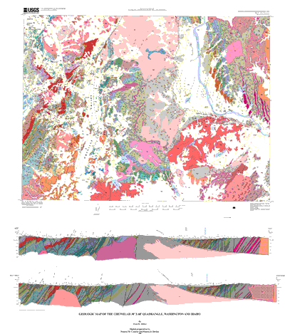
Cartographic line entities are contained in CHEW_XS (two cross-section traces) and CHEW_LDR (unit label leaders). These line entities have only one attribute, L-SYMB, and all have the same value, 1.
Entity_and_Attribute_Detail_Citation:
A complete description of the polygon, line, and point data coding schemes is available in U.S. Geological Survey Open-File Reports OFR 97-859, OFR 97-860, and OFR 97-861 (full source citations follow):
Matti, J.C., Miller, F.K., Powell, R.E., Kennedy, S.A., Bunyapanasarn, T.P., Koukladas, Catherine, Hauser, R.M., and Cossette, P.M., 1997b, Geologic-point attributes for digital geologic-map databases produced by the Southern California Areal Mapping Project (SCAMP), Version 1.0: U.S.Geological Survey Open-File Report 97-859
Matti, J.C., Miller, F.K., Powell, R.E., Kennedy, S.A., and Cossette, P.M., 1997c, Geologic-polygon attributes for digital geologic-map databases produced by the Southern California Areal Mapping Project (SCAMP), Version 1.0: U.S.Geological Survey Open-File Report 97-860
Matti, J.C., Powell, R.E., Miller, F.K., Kennedy, S.A., Ruppert, K.R., Morton, G.L., and Cossette, P.M., 1997a, Geologic-line attributes for digital geologic-map databases produced by the Southern California Areal Mapping Project (SCAMP), Version 1.0: U.S.Geological Survey Open-File Report 97-861
Distribution_Information:
Distributor:
Contact_Information:
Contact_Organization_Primary:
Contact_Organization: U.S. Geological Survey Information Services
Contact_Address:
Address_Type: mailing address
Address: Box 25286 Denver Federal Center
City: Denver
State_or_Province: CO
Postal_Code: 80225
Country: USA
Contact_Voice_Telephone: 303-202-4700
Contact_Facsimile_Telephone: 303-202-4693
Resource_Description: USGS Miscellaneous Field Studies Map MF-2354
Distribution_Liability:
The U.S. Geological Survey (USGS) provides these geographic data "as is. "The USGS makes no guarantee or warranty concerning the accuracy of information contained in the geographic data. The USGS further makes no warranties, either expressed or implied as to any other matter whatsoever, including, without limitation, the condition of the product, or its fitness for any particular purpose. The burden for determining fitness for use lies entirely with the user. Although these data have been processed successfully on computers at the USGS, no warranty, expressed or implied, is made by the USGS regarding the use of these data on any other system, nor does the fact of distribution constitute or imply any such warranty.
In no event shall the USGS have any liability whatsoever for payment of any consequential, incidental, indirect, special, or tort damages of any kind, including, but not limited to, any loss of profits arising out of use of or reliance on the geographic data or arising out of the delivery, installation, operation, or support by USGS.
This digital, geologic map database of the Chewelah 30' x 60' quadrangle, 1:100,000 map-scale, and any derivative maps thereof, is not meant to be used or displayed at any scale larger than 1:100,000 (e.g., 1:24,000).
Standard_Order_Process:
Digital_Form:
Digital_Transfer_Information:
Format_Name: ARCE
Format_Version_Number: 7.1.1
Format_Information_Content:
Geologic contacts, faults, unit labels, attitudes, dip values, lines of cross section, and base map information including topography, roads, and other cultural information
File_Decompression_Technique: tar and gzip
Transfer_Size: 5.8
Digital_Transfer_Option:
Online_Option:
Computer_Contact_Information:
Network_Address:
Fees: none
Metadata_Reference_Information:
Metadata_Date: 20160610
Metadata_Review_Date: 20010131
Metadata_Contact:
Contact_Information:
Contact_Person_Primary:
Contact_Person: Peter N Schweitzer
Contact_Organization: USGS Midwest Area
Contact_Position:
Collection manager, USGS Geoscience Data Clearinghouse, http://geo-nsdi.er.usgs.gov/
Contact_Address:
Address_Type: mailing address
Address:
Mail Stop 954
12201 Sunrise Valley Dr
City: Reston
State_or_Province: VA
Postal_Code: 20192-0002
Country: USA
Contact_Voice_Telephone: 703-648-6533
Contact_Facsimile_Telephone: 703-648-6252
Contact_Electronic_Mail_Address: pschweitzer@usgs.gov
Metadata_Standard_Name: Content Standard for Digital Geospatial Metadata
Metadata_Standard_Version: FGDC-STD-001-1998
Metadata_Access_Constraints: none
Metadata_Use_Constraints: none
Metadata_Extensions:

This page is <https://geo-nsdi.er.usgs.gov/metadata/map-mf/2354/metadata.html>
Generated by mp version 2.9.48 on Tue Jul 03 20:05:05 2018