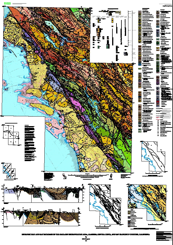
Attribute_Label: PTYPE
Attribute_Definition: Geologic unit label
Attribute_Definition_Source: author
Attribute_Domain_Values:
Enumerated_Domain:
Enumerated_Domain_Value: H2O
Enumerated_Domain_Value_Definition: water
Attribute_Domain_Values:
Enumerated_Domain:
Enumerated_Domain_Value: Jb
Enumerated_Domain_Value_Definition: Massive basalt and diabase
Attribute_Domain_Values:
Enumerated_Domain:
Enumerated_Domain_Value: Jgb
Enumerated_Domain_Value_Definition: Gabbro
Attribute_Domain_Values:
Enumerated_Domain:
Enumerated_Domain_Value: Jpb
Enumerated_Domain_Value_Definition: Pillow basalt and basalt breccia
Attribute_Domain_Values:
Enumerated_Domain:
Enumerated_Domain_Value: Jpb?
Enumerated_Domain_Value_Definition: Pillow basalt and basalt breccia, identification uncertain
Attribute_Domain_Values:
Enumerated_Domain:
Enumerated_Domain_Value: Jsv
Enumerated_Domain_Value_Definition: Keratophyre and quartz keratophyre
Attribute_Domain_Values:
Enumerated_Domain:
Enumerated_Domain_Value: KJf
Enumerated_Domain_Value_Definition: Undivided Franciscan complex rocks
Attribute_Domain_Values:
Enumerated_Domain:
Enumerated_Domain_Value: KJfm
Enumerated_Domain_Value_Definition: Franciscan complex, melange
Attribute_Domain_Values:
Enumerated_Domain:
Enumerated_Domain_Value: KJfs
Enumerated_Domain_Value_Definition: Franciscan complex, undivided sandstone
Attribute_Domain_Values:
Enumerated_Domain:
Enumerated_Domain_Value: KJfy
Enumerated_Domain_Value_Definition: Franciscan complex, metasandstone of the Yolla Bolly terrane
Attribute_Domain_Values:
Enumerated_Domain:
Enumerated_Domain_Value: KJk
Enumerated_Domain_Value_Definition: Knoxville Formation
Attribute_Domain_Values:
Enumerated_Domain:
Enumerated_Domain_Value: KJkc
Enumerated_Domain_Value_Definition: Knoxville Formation, conglomerate beds
Attribute_Domain_Values:
Enumerated_Domain:
Enumerated_Domain_Value: KJkv
Enumerated_Domain_Value_Definition: Knoxville Formation, volcanoclastic breccia
Attribute_Domain_Values:
Enumerated_Domain:
Enumerated_Domain_Value: Kc
Enumerated_Domain_Value_Definition: Conglomerate interbeds (Cretaceous)
Attribute_Domain_Values:
Enumerated_Domain:
Enumerated_Domain_Value: Kcg
Enumerated_Domain_Value_Definition: Redwood Canyon Formation, conglomerate beds
Attribute_Domain_Values:
Enumerated_Domain:
Enumerated_Domain_Value: Kcs
Enumerated_Domain_Value_Definition: Massive quartz arenite (Cretaceous)
Attribute_Domain_Values:
Enumerated_Domain:
Enumerated_Domain_Value: Kcv
Enumerated_Domain_Value_Definition:
Unnamed sandstone, conglomerate, and shale of the Castro Valley area (Late Cretaceous)
Attribute_Domain_Values:
Enumerated_Domain:
Enumerated_Domain_Value: Kfa
Enumerated_Domain_Value_Definition: Franciscan complex, sandstone of the Alcatraz terrane
Attribute_Domain_Values:
Enumerated_Domain:
Enumerated_Domain_Value: Kfgm
Enumerated_Domain_Value_Definition: Franciscan complex, quartz diorite of the Novato Quarry terrane
Attribute_Domain_Values:
Enumerated_Domain:
Enumerated_Domain_Value: Kfn
Enumerated_Domain_Value_Definition: Franciscan complex, sandstone of the Novato Quarry terrane
Attribute_Domain_Values:
Enumerated_Domain:
Enumerated_Domain_Value: Kjm
Enumerated_Domain_Value_Definition: Joaquin Miller Formation
Attribute_Domain_Values:
Enumerated_Domain:
Enumerated_Domain_Value: Ko
Enumerated_Domain_Value_Definition: Oakland Formation
Attribute_Domain_Values:
Enumerated_Domain:
Enumerated_Domain_Value: Kp
Enumerated_Domain_Value_Definition: Pinehurst Shale
Attribute_Domain_Values:
Enumerated_Domain:
Enumerated_Domain_Value: Kr
Enumerated_Domain_Value_Definition: Redwood Canyon Formation
Attribute_Domain_Values:
Enumerated_Domain:
Enumerated_Domain_Value: Ksc
Enumerated_Domain_Value_Definition: Shephard Creek Formation
Attribute_Domain_Values:
Enumerated_Domain:
Enumerated_Domain_Value: Ksh
Enumerated_Domain_Value_Definition: Siltstone and shale (Cretaceous)
Attribute_Domain_Values:
Enumerated_Domain:
Enumerated_Domain_Value: Kslt
Enumerated_Domain_Value_Definition: Redwood Canyon Formation, siltstone beds
Attribute_Domain_Values:
Enumerated_Domain:
Enumerated_Domain_Value: Kss
Enumerated_Domain_Value_Definition: Unnamed sandstone in the Oakland Hills (Cretaceous)
Attribute_Domain_Values:
Enumerated_Domain:
Enumerated_Domain_Value: Ku
Enumerated_Domain_Value_Definition: Undivided Great Valley complex strata
Attribute_Domain_Values:
Enumerated_Domain:
Enumerated_Domain_Value: Kus
Enumerated_Domain_Value_Definition: Sandstone, siltstone, and shale (Cretaceous)
Attribute_Domain_Values:
Enumerated_Domain:
Enumerated_Domain_Value: QTi?
Enumerated_Domain_Value_Definition: Irvington gravels, identification uncertain
Attribute_Domain_Values:
Enumerated_Domain:
Enumerated_Domain_Value: QTu
Enumerated_Domain_Value_Definition: Undifferentiated continental gravels (Pleistocene and Pliocene)
Attribute_Domain_Values:
Enumerated_Domain:
Enumerated_Domain_Value: Qds
Enumerated_Domain_Value_Definition: Dune sand
Attribute_Domain_Values:
Enumerated_Domain:
Enumerated_Domain_Value: Qhaf
Enumerated_Domain_Value_Definition: Alluvial fan and fluvial deposits (Holocene)
Attribute_Domain_Values:
Enumerated_Domain:
Enumerated_Domain_Value: Qhaf1
Enumerated_Domain_Value_Definition: Younger alluvial fan deposits
Attribute_Domain_Values:
Enumerated_Domain:
Enumerated_Domain_Value: Qhasc
Enumerated_Domain_Value_Definition: Artificial stream channels
Attribute_Domain_Values:
Enumerated_Domain:
Enumerated_Domain_Value: Qhb
Enumerated_Domain_Value_Definition: Basin deposits
Attribute_Domain_Values:
Enumerated_Domain:
Enumerated_Domain_Value: Qhbm
Enumerated_Domain_Value_Definition: Bay mud
Attribute_Domain_Values:
Enumerated_Domain:
Enumerated_Domain_Value: Qhbr
Enumerated_Domain_Value_Definition: Beach ridge deposits
Attribute_Domain_Values:
Enumerated_Domain:
Enumerated_Domain_Value: Qhbs
Enumerated_Domain_Value_Definition: Basin deposits, salt affected
Attribute_Domain_Values:
Enumerated_Domain:
Enumerated_Domain_Value: Qhfp
Enumerated_Domain_Value_Definition: Floodplain deposits
Attribute_Domain_Values:
Enumerated_Domain:
Enumerated_Domain_Value: Qhl
Enumerated_Domain_Value_Definition: Natural levee deposits
Attribute_Domain_Values:
Enumerated_Domain:
Enumerated_Domain_Value: Qhsc
Enumerated_Domain_Value_Definition: Stream channel deposits
Attribute_Domain_Values:
Enumerated_Domain:
Enumerated_Domain_Value: Qls
Enumerated_Domain_Value_Definition: Landslide deposits
Attribute_Domain_Values:
Enumerated_Domain:
Enumerated_Domain_Value: Qms
Enumerated_Domain_Value_Definition: Merrit sand
Attribute_Domain_Values:
Enumerated_Domain:
Enumerated_Domain_Value: Qmt
Enumerated_Domain_Value_Definition: Marine terrace deposits
Attribute_Domain_Values:
Enumerated_Domain:
Enumerated_Domain_Value: Qpaf
Enumerated_Domain_Value_Definition: Alluvial fan and fluvial deposits (Pleistocene)
Attribute_Domain_Values:
Enumerated_Domain:
Enumerated_Domain_Value: Qpaf1
Enumerated_Domain_Value_Definition: Alluvial terrace deposits
Attribute_Domain_Values:
Enumerated_Domain:
Enumerated_Domain_Value: Qpoaf
Enumerated_Domain_Value_Definition: Older alluvial fan deposits
Attribute_Domain_Values:
Enumerated_Domain:
Enumerated_Domain_Value: Ta
Enumerated_Domain_Value_Definition: Unnamed glauconitic sandstone (Paleocene)
Attribute_Domain_Values:
Enumerated_Domain:
Enumerated_Domain_Value: Tbd
Enumerated_Domain_Value_Definition: Briones Formation, D member
Attribute_Domain_Values:
Enumerated_Domain:
Enumerated_Domain_Value: Tbe
Enumerated_Domain_Value_Definition: Briones Formation, E member
Attribute_Domain_Values:
Enumerated_Domain:
Enumerated_Domain_Value: Tbf
Enumerated_Domain_Value_Definition: Briones Formation, F member
Attribute_Domain_Values:
Enumerated_Domain:
Enumerated_Domain_Value: Tbg
Enumerated_Domain_Value_Definition: Briones Formation, G member
Attribute_Domain_Values:
Enumerated_Domain:
Enumerated_Domain_Value: Tbgc
Enumerated_Domain_Value_Definition: Briones Formation, G member, conglomerate beds
Attribute_Domain_Values:
Enumerated_Domain:
Enumerated_Domain_Value: Tbgl
Enumerated_Domain_Value_Definition: Briones Formation, G member, limestone beds
Attribute_Domain_Values:
Enumerated_Domain:
Enumerated_Domain_Value: Tbh
Enumerated_Domain_Value_Definition: Briones Formation, Hercules shale member
Attribute_Domain_Values:
Enumerated_Domain:
Enumerated_Domain_Value: Tbi
Enumerated_Domain_Value_Definition: Briones Formation, I member
Attribute_Domain_Values:
Enumerated_Domain:
Enumerated_Domain_Value: Tbl
Enumerated_Domain_Value_Definition: Briones Formation, lower member
Attribute_Domain_Values:
Enumerated_Domain:
Enumerated_Domain_Value: Tbp
Enumerated_Domain_Value_Definition: Bald Peak Basalt
Attribute_Domain_Values:
Enumerated_Domain:
Enumerated_Domain_Value: Tbr
Enumerated_Domain_Value_Definition: Briones Formation
Attribute_Domain_Values:
Enumerated_Domain:
Enumerated_Domain_Value: Tbu
Enumerated_Domain_Value_Definition: Briones Formation, upper member
Attribute_Domain_Values:
Enumerated_Domain:
Enumerated_Domain_Value: Tc
Enumerated_Domain_Value_Definition: Cierbo Sandstone
Attribute_Domain_Values:
Enumerated_Domain:
Enumerated_Domain_Value: Tcc
Enumerated_Domain_Value_Definition: Claremont Chert
Attribute_Domain_Values:
Enumerated_Domain:
Enumerated_Domain_Value: Tccs
Enumerated_Domain_Value_Definition: Claremont Shale, sandstone and siltstone beds
Attribute_Domain_Values:
Enumerated_Domain:
Enumerated_Domain_Value: Tccs?
Enumerated_Domain_Value_Definition:
Claremont Shale, sandstone and siltstone beds, identification uncertain
Attribute_Domain_Values:
Enumerated_Domain:
Enumerated_Domain_Value: Tcgl
Enumerated_Domain_Value_Definition: Conglomerate, sandstone, siltstone (Pliocene and Miocene)
Attribute_Domain_Values:
Enumerated_Domain:
Enumerated_Domain_Value: Tcglt
Enumerated_Domain_Value_Definition: Rhyolite tuff interbeds (Pliocene)
Attribute_Domain_Values:
Enumerated_Domain:
Enumerated_Domain_Value: Tchs
Enumerated_Domain_Value_Definition: Unnamed shale (Miocene)
Attribute_Domain_Values:
Enumerated_Domain:
Enumerated_Domain_Value: Tcs
Enumerated_Domain_Value_Definition: Claremont Shale
Attribute_Domain_Values:
Enumerated_Domain:
Enumerated_Domain_Value: Tdi
Enumerated_Domain_Value_Definition: Diatomite (Miocene)
Attribute_Domain_Values:
Enumerated_Domain:
Enumerated_Domain_Value: Tes
Enumerated_Domain_Value_Definition: Unnamed mudstone (Eocene)
Attribute_Domain_Values:
Enumerated_Domain:
Enumerated_Domain_Value: Tes?
Enumerated_Domain_Value_Definition: Unnamed mudstone (Eocene), identification uncertain
Attribute_Domain_Values:
Enumerated_Domain:
Enumerated_Domain_Value: Tgvt
Enumerated_Domain_Value_Definition: Green Valley and Tassajara Formations
Attribute_Domain_Values:
Enumerated_Domain:
Enumerated_Domain_Value: Th
Enumerated_Domain_Value_Definition: Hambre Sandstone
Attribute_Domain_Values:
Enumerated_Domain:
Enumerated_Domain_Value: Th?
Enumerated_Domain_Value_Definition: Hambre Sandstone, identification uncertain
Attribute_Domain_Values:
Enumerated_Domain:
Enumerated_Domain_Value: Tlt
Enumerated_Domain_Value_Definition: Lafayette Tuff
Attribute_Domain_Values:
Enumerated_Domain:
Enumerated_Domain_Value: Tmb
Enumerated_Domain_Value_Definition: Moraga Formation
Attribute_Domain_Values:
Enumerated_Domain:
Enumerated_Domain_Value: Tmll
Enumerated_Domain_Value_Definition: Mullholland Formation, lower member
Attribute_Domain_Values:
Enumerated_Domain:
Enumerated_Domain_Value: Tmls
Enumerated_Domain_Value_Definition: Mullholland Formation, lower member, sandstone marker beds
Attribute_Domain_Values:
Enumerated_Domain:
Enumerated_Domain_Value: Tmlu
Enumerated_Domain_Value_Definition: Mullholland Formation, upper member
Attribute_Domain_Values:
Enumerated_Domain:
Enumerated_Domain_Value: Tmru
Enumerated_Domain_Value_Definition: Muir Sandstone, upper member
Attribute_Domain_Values:
Enumerated_Domain:
Enumerated_Domain_Value: Tms
Enumerated_Domain_Value_Definition: Moraga Formation, interbedded sandstone
Attribute_Domain_Values:
Enumerated_Domain:
Enumerated_Domain_Value: Tmu
Enumerated_Domain_Value_Definition: Mudstone, shale, and siltstone (Miocene)
Attribute_Domain_Values:
Enumerated_Domain:
Enumerated_Domain_Value: Tn
Enumerated_Domain_Value_Definition: Neroly Sandstone
Attribute_Domain_Values:
Enumerated_Domain:
Enumerated_Domain_Value: Tn?
Enumerated_Domain_Value_Definition: Neroly Sandstone, identification uncertain
Attribute_Domain_Values:
Enumerated_Domain:
Enumerated_Domain_Value: To
Enumerated_Domain_Value_Definition: Oursan Sandstone
Attribute_Domain_Values:
Enumerated_Domain:
Enumerated_Domain_Value: To?
Enumerated_Domain_Value_Definition: Oursan Sandstone, identification uncertain
Attribute_Domain_Values:
Enumerated_Domain:
Enumerated_Domain_Value: Tor
Enumerated_Domain_Value_Definition: Orinda Formation
Attribute_Domain_Values:
Enumerated_Domain:
Enumerated_Domain_Value: Tr
Enumerated_Domain_Value_Definition: Rodeo Shale
Attribute_Domain_Values:
Enumerated_Domain:
Enumerated_Domain_Value: Tr?
Enumerated_Domain_Value_Definition: Rodeo Shale, identification uncertain
Attribute_Domain_Values:
Enumerated_Domain:
Enumerated_Domain_Value: Tro
Enumerated_Domain_Value_Definition:
Rodeo Shale, Hambre Sandstone, Tice Shale, and Oursan Sandstone, undivided
Attribute_Domain_Values:
Enumerated_Domain:
Enumerated_Domain_Value: Ts
Enumerated_Domain_Value_Definition: Sobrante Sandstone
Attribute_Domain_Values:
Enumerated_Domain:
Enumerated_Domain_Value: Ts?
Enumerated_Domain_Value_Definition: Sobrante Sandstone, identification uncertain
Attribute_Domain_Values:
Enumerated_Domain:
Enumerated_Domain_Value: Tsa
Enumerated_Domain_Value_Definition: Sandstone (Miocene)
Attribute_Domain_Values:
Enumerated_Domain:
Enumerated_Domain_Value: Tshc
Enumerated_Domain_Value_Definition: Shale and claystone (Eocene)
Attribute_Domain_Values:
Enumerated_Domain:
Enumerated_Domain_Value: Tsm
Enumerated_Domain_Value_Definition: Unnamed glauconitic mudstone (Miocene and Oligocene?)
Attribute_Domain_Values:
Enumerated_Domain:
Enumerated_Domain_Value: Tsms
Enumerated_Domain_Value_Definition: Interbedded sandstone (Miocene and Oligocene?)
Attribute_Domain_Values:
Enumerated_Domain:
Enumerated_Domain_Value: Tsr
Enumerated_Domain_Value_Definition: San Ramon Sandstone
Attribute_Domain_Values:
Enumerated_Domain:
Enumerated_Domain_Value: Tss
Enumerated_Domain_Value_Definition: Sandstone (Miocene)
Attribute_Domain_Values:
Enumerated_Domain:
Enumerated_Domain_Value: Tst
Enumerated_Domain_Value_Definition: Siesta Formation
Attribute_Domain_Values:
Enumerated_Domain:
Enumerated_Domain_Value: Tt
Enumerated_Domain_Value_Definition: Tice Shale
Attribute_Domain_Values:
Enumerated_Domain:
Enumerated_Domain_Value: Tt?
Enumerated_Domain_Value_Definition: Tice Shale, identification uncertain
Attribute_Domain_Values:
Enumerated_Domain:
Enumerated_Domain_Value: Tts
Enumerated_Domain_Value_Definition: Tuffaceous sandstone (Miocene? or Oligocene)
Attribute_Domain_Values:
Enumerated_Domain:
Enumerated_Domain_Value: Tub
Enumerated_Domain_Value_Definition: Interbedded basalt (Miocene)
Attribute_Domain_Values:
Enumerated_Domain:
Enumerated_Domain_Value: Tuc
Enumerated_Domain_Value_Definition: Unnamed conglomerate (Miocene)
Attribute_Domain_Values:
Enumerated_Domain:
Enumerated_Domain_Value: Tul
Enumerated_Domain_Value_Definition: Interbedded limestone (Miocene)
Attribute_Domain_Values:
Enumerated_Domain:
Enumerated_Domain_Value: Tus
Enumerated_Domain_Value_Definition: Unnamed sedimentary and volcanic rocks (Miocene)
Attribute_Domain_Values:
Enumerated_Domain:
Enumerated_Domain_Value: Tush
Enumerated_Domain_Value_Definition: Unnamed gray mudstone (Miocene)
Attribute_Domain_Values:
Enumerated_Domain:
Enumerated_Domain_Value: Tvh
Enumerated_Domain_Value_Definition: Vine Hill Sandstone
Attribute_Domain_Values:
Enumerated_Domain:
Enumerated_Domain_Value: Tvhl
Enumerated_Domain_Value_Definition: Vine Hill Sandstone, lower member
Attribute_Domain_Values:
Enumerated_Domain:
Enumerated_Domain_Value: Tvhu
Enumerated_Domain_Value_Definition: Vine Hill Sandstone, upper member
Attribute_Domain_Values:
Enumerated_Domain:
Enumerated_Domain_Value: af
Enumerated_Domain_Value_Definition: Artificial fill
Attribute_Domain_Values:
Enumerated_Domain:
Enumerated_Domain_Value: alf
Enumerated_Domain_Value_Definition: Artificial levee fill
Attribute_Domain_Values:
Enumerated_Domain:
Enumerated_Domain_Value: fc
Enumerated_Domain_Value_Definition: Franciscan complex, melange, chert block
Attribute_Domain_Values:
Enumerated_Domain:
Enumerated_Domain_Value: fg
Enumerated_Domain_Value_Definition: Franciscan complex, melange, greenstone block
Attribute_Domain_Values:
Enumerated_Domain:
Enumerated_Domain_Value: fm
Enumerated_Domain_Value_Definition: Franciscan complex, melange, schist block
Attribute_Domain_Values:
Enumerated_Domain:
Enumerated_Domain_Value: fs
Enumerated_Domain_Value_Definition: Franciscan complex, melange, sandstone block
Attribute_Domain_Values:
Enumerated_Domain:
Enumerated_Domain_Value: sc
Enumerated_Domain_Value_Definition: Silica-carbonate rock
Attribute_Domain_Values:
Enumerated_Domain:
Enumerated_Domain_Value: sp
Enumerated_Domain_Value_Definition: Serpentinite
Attribute_Domain_Values:
Enumerated_Domain:
Enumerated_Domain_Value: sp?
Enumerated_Domain_Value_Definition: Serpentinite, identification uncertain
Attribute_Domain_Values:
Enumerated_Domain:
Enumerated_Domain_Value: spm
Enumerated_Domain_Value_Definition: Serpentinite matrix melange