Digital geologic map and map database of parts of Marin, San Francisco, Alameda, Contra Costa, and Sonoma Counties, California

Metadata also available as - [Questions & Answers] - [Parseable text] - [XML]

Metadata:

Identification_Information:
Citation:
Citation_Information:
Originator: Blake, M.C., Jr.
Originator: Graymer, R.W.
Originator: Jones, D.L.
Originator: Soule, A.
Publication_Date: 1999
Title:
Digital geologic map and map database of parts of Marin, San Francisco, Alameda, Contra Costa, and Sonoma Counties, California
Edition: 1.0
Geospatial_Data_Presentation_Form: geologic map
Series_Information:
Series_Name: U.S. Geological Survey Miscellaneous Field Studies Map
Issue_Identification: MF-2337
Publication_Information:
Publication_Place: Menlo Park, CA
Publisher: U.S. Geological Survey
Online_Linkage: http://pubs.usgs.gov/mf/2000/2337/
Description:
Abstract:
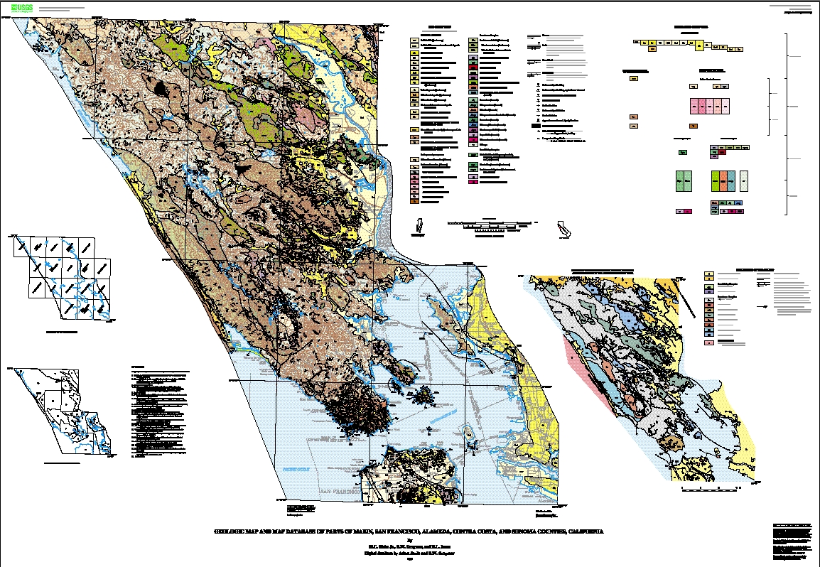
This digital map database, compiled from previously published and unpublished data, and new mapping by the authors, represents the general distribution of bedrock and surficial deposits in the mapped area. Together with the accompanying text file (mageo.txt, mageo.pdf, or mageo.ps), it provides current information on the geologic structure and stratigraphy of the area covered. The database delineates map units that are identified by general age and lithology following the stratigraphic nomenclature of the U.S. Geological Survey. The scale of the source maps limits the spatial resolution (scale) of the database to 1:62,500 or smaller.
Purpose:
This database and accompanying plot files depict the distribution of geologic materials and structures at a regional (1:62,500) scale. The report is intended to provide geologic information for the regional study of materials properties, earthquake shaking, landslide potential, mineral hazards, seismic velocity, and earthquake faults. In addition, the report contains new information and interpretations about the regional geologic history and framework. However, the regional scale of this report does not provide sufficient detail for site development purposes. In addition, this map does not take the place of fault-rupture hazard zones designated by the California State Geologist (Hart and Bryant, 1997). Similarly, the database cannot be used to identify or delineate landslides in the region.
Supplemental_Information:
The databases in this report were compiled in ARC/INFO, a commercial Geographic Information System (Environmental Systems Research Institute, Redlands, California), with version 3.0 of the menu interface ALACARTE (Fitzgibbon and Wentworth, 1991, Fitzgibbon, 1991, Wentworth and Fitzgibbon, 1991). The files are in either GRID (ARC/INFO raster data) format or COVERAGE (ARC/INFO vector data) format. Coverages are stored in uncompressed ARC export format (ARC/INFO version 7.x). ARC/INFO export files (files with the .e00 extension) can be converted into ARC/INFO coverages in ARC/INFO (see below) and can be read by some other Geographic Information Systems, such as MapInfo via ArcLink and ESRI's ArcView (version 1.0 for Windows 3.1 to 3.11 is available for free from ESRI's web site: http://www.esri.com). The digital compilation was done in version 7.1.1 of ARC/INFO with version 3.0 of the menu interface ALACARTE (Fitzgibbon and Wentworth, 1991, Fitzgibbon, 1991, Wentworth and Fitzgibbon, 1991).
The geologic map information was digitized from stable originals of the geologic maps at 1:62,500 scale. The author manuscripts (pen on mylar) were scanned using a Altek monochrome scanner with a resolution of 800 dots per inch. The scanned images were vectorized and transformed from scanner coordinates to projection coordinates with digital tics placed by hand at quadrangle corners. The scanned lines were edited interactively by hand using ALACARTE, color boundaries were tagged as appropriate, and scanning artifacts visible at 1:24,000 were removed.
Revisions: 8/31/99 This is the pre-release version of the report. There have been no revisions to any part of the report.
Data Revision List
  File        Report Version        Last Update
              Last Updated

  mamap.ps      1.0
  maexpl.ps     1.0
  mageo.ps      1.0
  mamap.pdf     1.0
  maexpl.pdf    1.0
  mageo.pdf     1.0
  ma-geol.e00   1.0
  ma-strc.e00   1.0
  ma-blks.e00   1.0
  ma-altr.e00   1.0
  ma-quad.e00   1.0
  ma-corr.e00   1.0
  ma-so.e00     1.0
  ma-terr.e00   1.0
  mageo.txt     1.0
  mafig1.tif    1.0
  mafig2.tif    1.0
  madb.ps       1.0
  madb.pdf      1.0
  madb.txt      1.0
  import.aml    1.0
  mageol.met    1.0
Reviews_Applied_to_Data:
This report has undergone two scientific peer reviews, one digital database review, one review for conformity with geologic names policy, and review of the plotfiles for conformity with USGS map standards.
Related_Spatial_and_Tabular_Data_Sets:
This report consists of a set of geologic map database files (Arc/Info coverages) and supporting text and plotfiles. In addition, the report includes two sets of plotfiles (PostScript and PDF format) that will generate map sheets and pamphlets similar to a traditional USGS Miscellaneous Field Studies Report. These files are described below:
  ARC/INFO     Resultant	  Description of Coverage
  export file  Coverage
  -----------  -----------  --------------------------------
  ma-geol.e00  ma-geol/     Polygon and line coverage showing faults,
                            depositional contacts, and rock units
                            in the map area.

  ma-strc.e00  ma-strc/     Point and line coverage showing strike and dip
                            information and fold axes.

  ma-blks.e00  ma-blks/     Point coverage showing location of high-grade
                            blocks in Franciscan rock units.

  ma-altr.e00  ma-altr/     Polygon coverage showing areas of hydrothermal
                            alteration.

  ma-quad.e00  ma-quad/     Line coverage showing index map of quadrangles
                            in the map area.  Lines and annotation only.

  ma-corr.e00  ma-corr/     Polygon and line coverage of the correlation
                            table for the units in this map database.
                            This database is not geospatial.

  ma-so.e00    ma-so/       Line coverage showing sources of data index
                            map for this map database.

  ma-terr.e00  ma-terr/     Polygon and line coverage of the index map of
                            tectonostratigraphic terranes in the map area.
                            (Terranes are described in mageo.txt,
                            mageo.ps, or mageo.pdf).
ASCII text files, including explanatory text, ARC/INFO key files, PostScript and PDF plot files, and a ARC Macro Language file for conversion of ARC export files into ARC coverages:
  mageo.ps                A PostScript plot file of a report containing
                          detailed unit descriptions and geological
                          information, plus sources of data and references
                          cited, with two figures.

  mageo.pdf               A PDF version of mageo.ps.

  mageo.txt               A text-only file containing an unformatted
                          version of mageo.ps without figures.

  mafig1.tif              A TIFF file of Figure 1 from mageo.ps

  mafig2.tif              A TIFF file of Figure 2 from mageo.ps

  madb.ps                 A PostScript plot file of a pamphlet containing
                          detailed information about the contents and
                          availability of this report.

  madb.pdf                A PDF version of madb.ps.

  madb.txt                A text-only file containing an unformatted
                          version of madb.ps.

 import.aml               ASCII text file in ARC Macro Language to convert
                          ARC export files to ARC coverages in ARC/INFO.

  mamap.ps                A PostScript plottable file containing an image
                          of the geologic map and base maps at a scale of
                          1:62,500, along with a simple map key.

  maexpl.ps               A PostScript plot file containing an image of
                          the explanation sheet, including terrane map,
                          index maps, correlation chart, and unit
                          descriptions.

  mamap.pdf               A PDF file containing an image of the geologic
                          map and base maps at a scale of 1:62,500, along
                          with a simple map key.

  maexpl.pdf              A PDF file containing an image of the
                          explanation sheet, including terrane map, index
                          maps, correlation chart, and unit descriptions.
Base maps
Base Map layers used in the preparation of the geologic map plotfiles were derived from published digital maps (Aitken, 1997), The base map digital files are not included in the digital database package.
Other_References_Cited:
Aitken, D.S., 1997, A digital version of the 1970 U.S. Geological Survey topographic map of the San Francisco Bay region, three sheets, 1:125,000 scale: U.S. Geological Survey Open-File Report 97-500.
Armstrong, C. F., and Gallagher, Kathy, 1977, Fossils from the Franciscan assemblage, Alcatraz Island: California Geology, v. 30, p. 134.
Bailey, E. H., Blake, C. M., and Jones, D. L., 1970, On-land Mesozoic oceanic crust in California Coast Ranges: U.S. Geol. Prof. Paper 700-C; C70-C81.
Bailey, E. H., Irwin, W. P., and Jones, D. L., 1964, Franciscan and related rocks and their significance in the geology of western California: Calif. Div. Mines and Geology, Bull. 183, 177 p.
Berkland, J. O., 1964, Swelling vermiculite clay in the Franciscan Formation ofnorthern California--Its role in possible chemical stabilization of mobileslopes: Paper presented to the National Convention of the Assoc. of Engineering Geologists, Sacramento, CA, 6 p.
Berkland, J. O., 1969, Geology of the Novato quadrangle, Marin Co., CA: Unpublished M.S. thesis, San Jose State University, San Jose, CA.
Blake, M. C., Jr., Bartow, J. A., Frizzell, V. A., Jr., Schlocker, Julius, Sorg, Dennis, Wentworth, C. M., and Wright, R. H., 1974, Preliminary geologic map of Marin and San Francisco Counties and parts of Alameda, Contra Costa, and Sonoma Counties, California: U. S. Geol. Survey Map MF-574.
Blake, M. C., Jr., Howell, D. G., and Jayko, A. S., 1984, Tectonostratigraphic terranes of the San Francisco Bay Region, in Blake, M. C., ed., 1984, Franciscan Geology of Northern California: Pacific Section S.E.P.M., Vol. 43, p. 5-22.
Blake, M. C., Jr., Howell, D. G., and Jones, D. L., 1982, Preliminary tectonostratigraphic terrane map of California: U. S. Geol. Survey Open-File Report 82-593, 9 p., 3 maps, scale 1: 750, 000.
Blake, M. C., Jr., Irwin, W. P., and Coleman, R. G., 1967, Upside-down metamorphic zonation, blueschist facies, along a regional thrust in California and Oregon: U. S. Geol. Survey Prof. Paper 575C, p. 1-9.
Blake, M. C., Jr., and Jones, D. L., 1974, Origin of Franciscan melanges in northern California: S.E.P.M., Special Paper No. 19, p. 255-263.
Blake, M.C., Jr., and Wentworth, C.M., 1999, Structure and metamorphism of the Franciscan Complex, Mt. Hamilton area, Northern California: International rgGeology Review, v. 41, p. 417-424.
Bonilla, M. G., 1971, Preliminary geolgic map of the San Francisco South quadrangle and part of the Hunters Point quadrangle, California: U.S. Geol. Survey Misc. Field Studies Map MF-311, (1:24,000).
Brown, R. D., Jr., 1970, Faults that are historically active or that show evidence of geologically young surface displacement, San Francisco Bay Region: A progress report: Oct. 1970, U.S. Geol. Survey Open File Map, (1:250,000).
Brown, R. D., and Wolfe, E. W., 1970, Map showing recently active breaks along the San Andreas fault between Pt. Delgada and Bolinas Bay, California: U.S. Geol. Survey Open File Map, (1:48,000).
Brabb, E.E., Graymer, R.W., and Jones, D.L., 1998, Geology of the Palo Alto 30 X 60 minute quadrangle, California: A digital database: U.S. Geological Survey Open-File Report 98-348, includes plotfiles for 2 sheets, scale 1:100,000, database description pamphlet, 9 pp, geologic description and interpretation pamphlet, 16 p.
Budding, K.E., Schwartz, D.P., and Oppenheimer, D.H., 1991, Slip rate, earthquake recurrence, and seismogenic potential of the Rodgers Creek fault zone, Northern California; initial results: Geophysical Research Letters, v. 18, no. 3, p. 447-450.
Clague, J. J., 1969, The landslides in the southeast part of Point Reyes National Seashore: unpublished University of California at Berkeley M.A. thesis.
Clark, J.C., and Brabb, E.E., 1997, Geology of Point Reyes National Seashore and vicinity: a digital database: U.S. Geological Survey Open-File Report 97-456.
Clark, J. C., Wahrhaftig, Clyde, and Brabb, E. E., 1991, San Francisco to Point Reyes: Both sides of the San Andreas fault, in Sloan, D., and Wagner, D. L., eds., Geologic Excursions in Northern California: California Division of Mines and Geology, Special Publication 109, p. 11-23.
Coleman, R.G., 1996, [abs.], Prospecting for ophiolites in the California continental margin: Eos, Transactions of the American Geophysical Union, v. 77, no. 46, p. 743.
Coleman, R. G., and Lee, D. F., 1963, Glaucophane-bearing metamorphic rock types of the Cazadero area, California: Jour. Petrology, v. 4, pt. 2., p. 260-301.
Crawford, K.E., 1976, Reconnaissance geologic map of the Eylar Mountain quadrangle, Santa Clara and Alameda Counties, California: U.S. Geological Survey Miscellaneous Field Studies Map MF-764, scale 1:24,000.
Curry, F. B., Cox, Allan, and Engebretson, D. C., 1984, Paleomagnetism of Franciscan rocks in the Marin Headlands, in Blake, M. C., Jr., ed., Franciscan Geology of Northern California: Pacific Section S.E.P.M., Vol. 43, p. 89-98.
Curtis, G. H., Evernden, J. F., and Lipson, J., 1958, Age determinations of some granitic rocks in California by the potassium-argon method: California Division of Mines Spec. Rpt. 54, 16 p.
Drinkwater, J.L., Sorg, D.H., and Russell, P.C., 1992, Geologic map showing ages and mineralization of the Quien Sabe Volcanics, Mariposa Peak quadrangle, west-central California: U.S. Geological Survey Miscellaneous Field Studies Map MF-2200, 1 sheet, scale 1:24,000.
Evarts, R.C., 1977, The geology and petrology of the Del Puerto ophiolite, Diablo Range, central California Coast Ranges, in Coleman, R.G., and Irwin, W.P., eds., North American ophiolites: Bulletin, Oregon Department of Geology and Mineral Industries, v. 95, p. 121-139.
Fitzgibbon, T.T., 1991, ALACARTE installation and system manual (version 1.0): U.S. Geological Survey Open-File Report 91-587B.
Fitzgibbon, T.T., and Wentworth, C.M., 1991, ALACARTE user interface - AML code and demonstration maps (version 1.0): U.S. Geological Survey Open-File Report 91-587A.
Fox, K.F., Jr., Fleck, R.J., Curtis, G.H., and Meyer, C.E., 1985a, Implications of the northwestwardly younger age of the volcanic rocks of west central California: Geological Society of America Bulletin, v. 96, p. 647-654.
Fox, K.F., Jr., Fleck, R.J., Curtis, G.H., and Meyer, C.E., 1985b, Potassium-argon and fission track ages of the Sonoma Volcanics in an area north of San Pablo Bay, California: U.S. Geological Survey Miscellaneous Field Studies Map MF-1753, 9 p., 1 sheet, scale 1:125,000.
Galloway, A.J., 1966, Point Reyes Peninsula and San Andreas fault zone, in Bailey, E.H., ed., Geology of Northern California: California Division of Mines and Geology Bulletin 190, p. 429-440.
Gluskoter, H. J., 1962, Geology of a portion of western Marin County, California: Unpublished Ph.D. thesis, University of California, Berkeley, CA, 184 p.
Gluskoter, H. J., 1969, Geology of a portion of western Marin County, California: California Division of Mines Map Sheet 11, (1:48,000).
Graymer, R.W., 1999, Offset history of the Hayward fault zone, San Francisco Bay region, California [abs.]: Geological Society of America Abstracts with Programs, v.
Graymer, R.W., Jones, D.L., and Brabb, E.E., 1996, Preliminary geologic map emphasizing bedrock formations in Alameda County, California: A digital database: U.S. Geological Survey Open-File Report 96-252, includes plotfiles for 2 sheets, scale 1:75,000, database description pamphlet, 14 p., geologic description and interpretation pamphlet, 33 p.
Graymer, R.W., Jones, D.L., and Brabb, E.E., 1999, Geology of the Cordelia and the northern part of the Benicia 7.5 minute quadrangles, California: A Digital Map Database: U.S. Geological Survey Open-File Report 99-162, includes plotfiles for one sheet, scale 1:24,000, database description pamphlet, 11 p., geologic description and interpretation pamphlet, 8 p.
Grimsich, J.L., Scott, G.R., Swisher, C.C., III, and Curtis, G.H., 1996, Paleomagnetism and 40Ar/39Ar dating of the Miocene Contra Costa Group, Berkeley Hills, California [abs.]: EOS, Transactions, American Geophysical Union, v. 77, no. 46, p. 165.
Gromme, Sherman, 1984, Paleomagnetism of Franciscan basalt, Marin County, California, revisited, in Blake, M. C., Jr., ed., Pacific Section S.E.P.M., Vol. 43, p. 113-119.
Hagstrum, J. T., and Murchey, B. L., 1993, Deposition of Franciscan Complex cherts along the paleoequator and accretion to the American margin at tropical paleolatitudes: Geol Soc. America, Bull., v. 105, p. 766-778.
Harms, T.A., Jayko, A.S., and Blake, M.C., Jr., 1992, Kinematic evidence for extensional unroofing of the Franciscan complex along the Coast Range fault, northern Diablo Range, California: Tectonics, v. 11, p. 228-241.
Hart, E.W., and Bryant, W.A., 1997, Fault-rupture hazard zones in California: California Division of Mines and Geology Special Publication 42, revised 1997, 38 p.
Irwin, W.P., 1973, Ophiolite belts in the Klamath Mountains: U.S. Geological Survey Professional Paper 850, 60 p.
James, E. W., Kimbrough, D. L., and Mattinson, J. M., 1993, Evaluation of displacements of pre-Tertiary rocks on the northern San Andreas fault using U-Pb zircon dating, initial Sr, and common Pb isotopic ratios, in Powell, R. E., Weldon, R. J. II, and Matti, J. C., eds., The San Andreas fault system; displacement, palinspastic reconstructions, and geologic evolution: Geol. Soc. America Memoir 178, p. 257-271.
Jayko, A. S., and Blake, M. C., Jr., 1984, Sedimentary petrology of graywacke of the Franciscan Complex in the northern San Francisco Bay Area, California, in Blake, M. C., Jr., ed., Franciscan Geology of Northern California: Pacific Section S.E.P.M., Vol. 43, p. 121-134.
Jayko, A. S., and Blake, M. C., Jr., 1993, Northward displacement of forearc slivers in the Coast Ranges of California and southwest Oregon during the late Mesozoic and early Cenozoic,in Dunn, G., and McDougall, K., eds., 1993, Mesozoic Paleogeography of the Western United States-II, Pacific Section SEPM, Book 71, p. 19-36.
Jones, D.L., 1987, Extensional faults in collisional settings; comparison of California and Japan [abs.]: Geological Society of America Abstracts with Programs, v. 19, no. 7, p. 720.
Jones, D.L., and Curtis, G.H., 1991, Guide to the geology of the Berkeley Hills, central Coast Ranges, California, in Sloan, D., and Wagner, D.L., eds., Geologic Excursions in Northern California: San Francisco to the Sierra Nevada, California Division of Mines and Geology Special Publication 109, p. 63-74.
Jones, D. L., Graymer, R. W., Wang, C., McEvilly, T. V., and Lomax, A, 1994, Neogene transpressive evolution of the California Coast Ranges: Tectonics, v. 13, p. 561-574.
Karl, S. M., 1984, Sedimentologic, diagenetic, and geochemical analysis of Upper Mesozoic ribbon cherts from the Franciscan assemblage at the Marin Headlands, California, in Blake, M. C., Jr., ed., 1984, Franciscan Geology of Northern California: Pacific Section S.E.P.M., Vol. 43, p. 71-88.
Krueger, S.W., and Jones, D.L., 1989, Extensional fault uplift of regional Franciscan blueschists due to subduction shallowing during the Laramide Orogeny: Geology, v. 17, p. 1157-1159.
Lawson, A. C., 1914, Description of the San Francisco District: U. S. Geol. Survey Folio 193.
Lawson, A.C., and others, 1908, The California earthquake of April 18, 1906--Report of the State Earthquake Investigation Commission: Carnegie Inst. Washington, Pub. 87, v. 1, 451 p.
Leith, C.J., 1949, Geology of the Quien Sabe quadrangle: California: California Division of Mines Bulletin 147, 60 p.
Lindquist, T.A., and Morganthaler, J.D., 1991, Radiometric ages of rocks in the San Francisco-San Jose quadrangles, California: Calif. Div. of Mines and Geol. Map No. 5, scale 1:250,000.
McLaughlin, R. J., Sliter, W. V., Sorg, D. H., Russell, P. C., and Sarna-Wojcicki, A. M., 1996, Large-scale right-slip displacement on the East San Francisco Bay Region fault system: Implications for location of late Miocene to Pliocene Pacific plate boundary: Tectonics, v. 15, p. 1-18.
Mankinen, E.A., 1972, Paleomagnetism and potassium-argon ages of the Sonoma Volcanics, California: Geological Society of America Bulletin, v. 83, p. 2063-2072.
Morse, R.R., and Bailey, T.L., 1935, Geological observations in the Petaluma district, California: Geological Society of America Bulletin, v. 46, p. 1437-1456.
Murchey, B. M., 1984, Stratigraphy and lithostratigraphy of chert in the Franciscan Complex, Marin Headlands, California, in Blake, M. C., Jr., ed., 1984, Franciscan Geology of Northern California: Pacific Section S.E.P.M., Vol. 43, p. 51-70.
Murchey, B. M., and Blake, M. C., Jr., 1993, Evidence for subduction of a major ocean plate along the California margin during the Middle to early Late Jurassic, in Dunn, G., and McDougall, K., eds., Mesozoic Paleogeography of the Western United States-II, Pacific Section SEPM Book 71, p. 1-18.
Murchey, B. M., and Jones, D. L., 1984, Age and significance of chert in the Franciscan Complex in the San Francisco Bay Region, in Blake, M. C., Jr., ed., Franciscan Geology of Northern California: Pacific Section S.E.P.M., Vol. 43, p. 23-30.
Murray, R.W., Bucholtz-tenBrink, M.R., Jones, D.L., Gerlach, D.C., Russ, G.P., III, 1990, Rare earth elements as indicators of different marine depositional environments in chert and shale: Geology, v. 18, no. 3, p. 268-271.
Nichols, D. R., and Wright, N. A., 1971, Preliminary map of historic margins of marshland, San Francisco Bay, California: U.S. Geol. Survey Open File Map (1:125,000).
Osuch, L.T., 1970, Geology of the Three Sisters quadrangle, California: Berkeley, University of California, M.S. thesis, 55 p.
O'Rourke, J. T., 1969, Geology of the San Anselmo Area: unpublished map, City of San Anselmo Planning Department, (1:480).
Page, B.M., 1966, Geology of the Coast Ranges of California, in Bailey, E.H., ed., Geology of Northern California: California Division of Mines and Geology Bulletin 190, p. 255-276.
______1970, Time of completion of underthrusting of Franciscan beneath Great Valley rocks west of Salinian block, California: Geological Society of America Bulletin, v. 81, no. 9, p. 2825-2833.
Radbruch, D. H., 1957, Areal and engineering geology of the Oakland west quadrangle, California: U.S. Geol. Survey Misc. Geol. Inv. Map I-239, scale 1:24,000.
Ross, D. C., 1972, Petrographic and chemical reconnaissance study of some granitic and gneissic rocks near the San Andreas fault from Bodega Head to Cajon Pass, California: U.S. Geol. Survey Prof. Paper 698.
Sarna-Wojcicki, A.M., 1976, Correlation of Late Cenozoic tuffs in the central Coast Ranges of California by means of trace- and minor-element chemistry: U.S. Geological Survey Professional Paper 972, 30 p.
Schlocker, Julius, 1974, Geology of the San Francisco North Quadrangle, California: U. S. Geol. Survey Prof. Paper 782, 109 p.
Schlocker, J., Bonilla, M. G., and Radbruch, D. H., 1958, Geology of the San Francisco North quadrangle, California: U.S. Geol. Survey Misc. Geol. Inv. Map I-272, scale 1:24,000.
Shervais, J. V., 1989, Geochemistry of igneous rocks from Marin Headlands, in Wahrhaftig, C. and Sloan, D., eds., Geology of San Francisco and Vicinity: 28th International Geol. Congress Field Trip Guidebook T105, Amer. Geophys. Union, p. 40-41.
Sliter, W. V., 1984, Foraminifers from Cretaceous limestone of the Franciscan Complex, northern California, in Blake, M. C., Jr., ed., Franciscan Geology of Northern California: Pacific Section S.E.P.M., Vol. 43, p. 149-162.
Sliter, W. V., McDougall, Kristin, Murchey, B. M., and Kohnen, E. V., 1993, Mesozoic and Cenozoic microfossils from geologic units within the San Jose 1:100,000 quadrangle, California: U. S. Geol. Survey Open-File report 93-344, map scale 1: 100, 000.
Swanson, S. E., and Schiffman, P., 1979, Textural evolution and metamorphism of pillow basalts from the Franciscan Complex, western Marin County, California: Contr. to Mineralogy and Petrology, v. 69, no. 3, p. 291-299.
Taliaferro, N.L., 1948, Geologic map of the Hollister quadrangle, California: California Division of Mines Bulletin 143, scale 1:62,500.
Tarduno, J. A., McWilliams, M., Debiche, M. G., Sliter, W. V., and Blake, M. C., Jr., 1985, Franciscan Complex Calera limestones--Accreted remnants of Farallon plate ocean plateaus: Nature, v. 317, p. 345- 347.
Ver Planck, W. E., 1953, Mines, mineral resources and mineral industries of Marin Co., California: California Journal of Mines and Geology, v. 51, no. 3, p. 221-289.
Wahrhaftig, Clyde, 1984, Structure of the Marin Headlands block, California: A progress report, in Blake, M. C., Jr., ed., 1984, Franciscan Geology of Northern California: Pacific Section S.E.P.M., Vol. 43, p. 31-50.
Wakabayashi, John, 1992, Nappes, tectonics of oblique plate convergence, and metamorphic evolution related to 140 million years of continuous subduction, Franciscan Complex, California: Journal of Geology, v. 100, p. 19-40.
Wentworth, C.M., Blake, M.C., Jr., Jones, D.L., Walter, A.W., and Zoback, M.D., 1984, Tectonic wedging associated with emplacement of the Franciscan Assemblage, California Coast Ranges, in , Blake, M.C., Jr., ed., Franciscan geology of Northern California: Pacific Section, Society of Economic Paleontologists and Mineralogists, Book 43, p. 163-174.
Wentworth, C.M., Blake, M.C., Jr., McLaughlin, R.J., and Graymer, R.W., 1998a, Preliminary geologic map of the San Jose 30 X 60 minute quadrangle, California: A digital map image: U.S. Geological Survey Open-File Report 98-795, includes plotfiles for 2 sheets, scale 1:100,000, database description pamphlet, 6 pp, geologic description and interpretation pamphlet, 47 p.
Wentworth, C. M., Jones, D. L., and Brabb, E. E., 1998b, Geology and regional correlation of the Cretaceous and Paleogene rocks of the Gualala block, California, in Elder, W.P., ed., Geology and tectonics of the Gualala block, Northern California: Pacific Section, Society of Economic Paleontologists and Mineralogists, Book 84, p. 3-26.
Wright, R.H., 1974, Map showing the distribution of potassium feldspar and fossils in Mesozoic rocks of Marin and San Francisco Counties, and parts of Alameda, Contra Costa, and Sonoma Counties, California: U.S. Geological Survey Miscellaneous Field Studies Map MF-573, 1 sheet, scale 1:125,000.
Wright, R.H., 1984, Geology of the Nicasio Reservoir terrane, Marin County, California, in Blake, M.C., Jr., ed., Franciscan geology of Northern California: Pacific Section, Society of Economic Paleontologists and Mineralogists, Book 43, p. 99-111.
Youngman, M.R., 1986, K-Ar and 40Ar/39Ar geochronology, geochemistry, and structural reinterpretation of the southern Sonoma Volcanic field, Sonoma County, California: Berkeley, University of California, M.S. thesis, 92 p., 1 plate.
Time_Period_of_Content:
Time_Period_Information:
Single_Date/Time:
Calendar_Date: 1999
Currentness_Reference:
The date given is the publication date. The information in the report is the most up-to-date available at the time of publication.
Status:
Progress: Pre-Publication
Maintenance_and_Update_Frequency: As needed
Spatial_Domain:
Bounding_Coordinates:
West_Bounding_Coordinate: -122.9902372
East_Bounding_Coordinate: -122.24855051
North_Bounding_Coordinate: 38.2626288
South_Bounding_Coordinate: 37.73826442
Keywords:
Theme:
Theme_Keyword_Thesaurus: USGS Thesaurus
Theme_Keyword: structural geology
Theme_Keyword: stratigraphy
Theme_Keyword: faulting (geologic)
Theme_Keyword: folding (geologic)
Theme_Keyword: geologic maps
Theme_Keyword: bedrock geologic units
Theme_Keyword: surficial geologic units
Theme_Keyword: geospatial datasets
Theme:
Theme_Keyword_Thesaurus: ISO 19115 Topic Categories
Theme_Keyword: geoscientificInformation
Theme:
Theme_Keyword_Thesaurus: none
Theme_Keyword: geology
Theme_Keyword: bedrock geology
Theme_Keyword: surficial geology
Theme_Keyword: geologic history
Theme_Keyword: Franciscan complex
Theme_Keyword: Coast Range ophiolite
Theme_Keyword: Great Valley complex
Theme_Keyword: terranes
Theme_Keyword: geologic structures
Theme_Keyword: Hayward fault
Theme_Keyword: Rodgers Creek fault
Theme_Keyword: Tolay fault
Theme_Keyword: San Andreas fault
Theme_Keyword: Miocene volcanics
Theme_Keyword: Sonoma Volcanics
Theme_Keyword: fault offset
Place:
Place_Keyword_Thesaurus: none
Place_Keyword: United States of America
Place_Keyword: California
Place_Keyword: Marin County
Place_Keyword: San Francisco County
Place_Keyword: Alameda County
Place_Keyword: Contra Costa County
Place_Keyword: Sonoma County
Stratum:
Stratum_Keyword_Thesaurus: None
Stratum_Keyword: Artificial fill
Stratum_Keyword: Artificial fill over marine and marsh deposits
Stratum_Keyword: Beach sand
Stratum_Keyword: Dune sand
Stratum_Keyword: Marine and marsh deposits
Stratum_Keyword: Landslide deposits
Stratum_Keyword: Alluvium
Stratum_Keyword: Slope debris and ravine fill
Stratum_Keyword: Undifferentiated surficial deposits
Stratum_Keyword: Volcanic gravel
Stratum_Keyword: Older beach deposits
Stratum_Keyword: Older alluvium
Stratum_Keyword: Marine and stream terrace deposits
Stratum_Keyword: Millerton Formation
Stratum_Keyword: Colma Formation
Stratum_Keyword: Merced Formation
Stratum_Keyword: Wilson Grove Formation
Stratum_Keyword: Petaluma Formation
Stratum_Keyword: Siltstone and claystone member
Stratum_Keyword: Gray claystone member
Stratum_Keyword: Sonoma Volcanics
Stratum_Keyword: Rhyolite lava flows
Stratum_Keyword: Rhyolite plugs and dikes
Stratum_Keyword: Andesite to basalt lava flows
Stratum_Keyword: Pumiceous ash flow tuff
Stratum_Keyword: Unnamed sandstone
Stratum_Keyword: Monterey Shale
Stratum_Keyword: Franciscan Complex
Stratum_Keyword: Sandstone and shale
Stratum_Keyword: Massive sandstone
Stratum_Keyword: Thin-bedded shale
Stratum_Keyword: Limestone and chert
Stratum_Keyword: Greenstone
Stratum_Keyword: Chert
Stratum_Keyword: Graywacke
Stratum_Keyword: Diabase
Stratum_Keyword: Metagraywacke
Stratum_Keyword: Chert
Stratum_Keyword: Greenstone and chert
Stratum_Keyword: Greenstone
Stratum_Keyword: Meta-greenstone
Stratum_Keyword: Metachert
Stratum_Keyword: Meta-greenstone and metachert
Stratum_Keyword: Greenstone
Stratum_Keyword: Metamorphic rocks, gneissic
Stratum_Keyword: Massive serpentinite
Stratum_Keyword: Melange
Stratum_Keyword: Great Valley Complex
Stratum_Keyword: Undivided sandstone, shale, and conglomerate
Stratum_Keyword: Novato Conglomerate
Stratum_Keyword: Sandstone and claystone
Stratum_Keyword: Serpentinite
Stratum_Keyword: Silica-carbonate rock
Temporal:
Temporal_Keyword_Thesaurus: None
Temporal_Keyword: Mesozoic
Temporal_Keyword: Jurassic
Temporal_Keyword: Cretaceous
Temporal_Keyword: Cenozoic
Temporal_Keyword: Tertiary
Temporal_Keyword: Neogene
Temporal_Keyword: Miocene
Temporal_Keyword: Pliocene
Temporal_Keyword: Quaternary
Temporal_Keyword: Pleistocene
Temporal_Keyword: Holocene
Theme:
Theme_Keyword_Thesaurus: National Geologic Map Database Catalog themes, augmented
Theme_Keyword: 1100 - Geology
Theme_Keyword: 1101 - General
Place:
Place_Keyword_Thesaurus: Augmented FIPS 10-4 and FIPS 6-4
Place_Keyword: f06041 = Marin
Place_Keyword: f06001 = Alameda
Place_Keyword: f06013 = Contra Costa
Place_Keyword: f06075 = San Francisco
Place_Keyword: f06097 = Sonoma
Access_Constraints: None
Use_Constraints:
Uses of this digital geologic map should not violate the spatial resolution of the data. Although the digital form of the data removes the constraint imposed by the scale of a paper map, the detail and accuracy inherent in map scale are also present in the digital data. The fact that this database was edited for a scale of 1:62,500 means that higher resolution information is not present in the dataset. Plotting at scales larger than 1:62,500 will not yield greater real detail, although it may reveal fine-scale irregularities below the intended resolution of the database. Similarly, where this database is used in combination with other data of higher resolution, the resolution of the combined output will be limited by the lower resolution of these data.
Point_of_Contact:
Contact_Information:
Contact_Organization_Primary:
Contact_Organization: USGS Western Geologic Mapping Team
Contact_Person: Database coordinator
Contact_Address:
Address_Type: mailing address
Address: 345 Middlefield Road, MS 975
City: Menlo Park
State_or_Province: CA
Postal_Code: 94025
Country: USA
Browse_Graphic:
Browse_Graphic_File_Name: http://pubs.usgs.gov/mf/2000/2337/images/mf2337h.jpg
Browse_Graphic_File_Description: Image of entire map
Browse_Graphic_File_Type: JPEG
Browse_Graphic:
Browse_Graphic_File_Name: http://pubs.usgs.gov/mf/2000/2337/mf2337f.pdf
Browse_Graphic_File_Description:
A PDF representation of the geologic map and base maps at a scale of 1:62,500 (Sheet 1). 4.6 megabytes.
Browse_Graphic_File_Type: PDF
Browse_Graphic:
Browse_Graphic_File_Name: http://pubs.usgs.gov/mf/2000/2337/mf2337g.pdf
Browse_Graphic_File_Description:
A PDF representation of the pamphlet accompanying the map, which contains textual and diagrammatic explanations of the geology, the map, and the database. 140 kilobytes.
Browse_Graphic_File_Type: PDF
Data_Set_Credit:
We would like to acknowledge our many colleagues at the USGS, University of California, and Stanford University for their many contributions over the years. We would especially like to acknowledge R.C. Jachens and E.E. Brabb for many organizational efforts, participation in the new mapping, ideas about regional structure, and insightful review of our draft manuscript.
We are grateful to the following U.S. Geological Survey paleontologists who have examined our fossils and provided ages necessary to establish the stratigraphic sequence and structure: David Bukry (Cretaceous and Tertiary nannoplankton), Kristin McDougall (Tertiary foraminifers), William Sliter (deceased - Cretaceous and Eocene foraminifers), John Barron (Tertiary diatoms), Charles Powell, II (Tertiary mollusks), and Bonita Murchey (Mesozoic radiolaria).
We are also very grateful to managers and staff of Chevron, EXXON, UNOCAL, ARCO, and Shell Petroleum Companies who have provided reports, maps, picked slides, and residues for about 25,000 microfossil localities in the San Francisco Bay Region.
Native_Data_Set_Environment: SunOS, 5.5.1, sun4u UNIX, ARC/INFO version 7.2.1
Data_Quality_Information:
Logical_Consistency_Report: Polygon and chain-node topology present
Completeness_Report:
The report is intended to describe completely the bedrock geology at 1:62,500 scale. Geologic information only mappable at larger scale has been omitted. In addition, landslide deposits are for the most part not recorded. Further, Quaternary surficial deposits in many areas have been intentionally undifferentiated.
Positional_Accuracy:
Horizontal_Positional_Accuracy:
Horizontal_Positional_Accuracy_Report:
Well located data items are intended to have a horizontal positional accuracy within .2 mm at 1:62,500 scale, or within 12.5 meters on the ground. The general positional accuracy of each line in the database is indicated within the LTYPE field in the Arc Attribute Table (see below). Points in the database are generally considered to be well located. The position of each data item is derived from the USGS topographic base map, and therefore additional inaccuracies arising from inaccuracies in the base map may also be encountered. See Aitken (1997) for information regarding the horizontal positional accuracy of the basemaps.
Vertical_Positional_Accuracy:
Vertical_Positional_Accuracy_Report:
No vertical positional data recorded. See Aitken (1997) for information regarding the vertical positional accuracy of the basemaps used to create the plotfiles of the geologic maps.
Lineage:
Source_Information:
Source_Citation:
Citation_Information:
Originator: Fox, K.F., Jr
Title: unpublished geologic map
Source_Time_Period_of_Content:
Time_Period_Information:
Single_Date/Time:
Calendar_Date: 1971
Source_Currentness_Reference: date of mapping
Source_Citation_Abbreviation: Fox, unpublished
Source_Contribution:
Source map for region 1 (see coverage ma-so or Sheet 2 plotfile maexpl.ps or maexpl.pdf)
Source_Information:
Source_Citation:
Citation_Information:
Originator: Brown, R.D., Jr
Publication_Date: 1970
Title:
Faults that are historically active or that show evidence of geologically young surface displacement, San Francisco Bay Region: A progress report
Series_Information:
Series_Name: U.S. Geological Survey Open-File Report
Source_Scale_Denominator: 250000
Type_of_Source_Media: paper
Source_Time_Period_of_Content:
Time_Period_Information:
Single_Date/Time:
Calendar_Date: 1970
Source_Currentness_Reference: publication date
Source_Citation_Abbreviation: Brown, 1970
Source_Contribution:
Source map for region 1 (see coverage ma-so or Sheet 2 plotfile maexpl.ps or maexpl.pdf)
Source_Information:
Source_Citation:
Citation_Information:
Originator: Weaver
Publication_Date: 1949
Title: (Weaver, 1949, region 2)
Source_Scale_Denominator: 62500
Source_Time_Period_of_Content:
Time_Period_Information:
Single_Date/Time:
Calendar_Date: 1949
Source_Currentness_Reference: publication date
Source_Citation_Abbreviation: (Weaver, 1949, region 2)
Source_Contribution:
Source map for region 2 (see coverage ma-so or Sheet 2 plotfile maexpl.ps or maexpl.pdf)
Source_Information:
Source_Citation:
Citation_Information:
Originator: Louke, G.
Publication_Date: unpublished
Title: unpublished geologic investigations
Type_of_Source_Media: paper
Source_Time_Period_of_Content:
Time_Period_Information:
Range_of_Dates/Times:
Beginning_Date: 1968
Ending_Date: 1970
Source_Currentness_Reference: date of mapping
Source_Citation_Abbreviation: Louke, unpublished (region 2)
Source_Contribution:
Source map for region 2 (see coverage ma-so or Sheet 2 plotfile maexpl.ps or maexpl.pdf)
Source_Information:
Source_Citation:
Citation_Information:
Originator: Bartow, J.A.
Title: unpublished photogeology and field reconnaissance
Type_of_Source_Media: paper
Source_Time_Period_of_Content:
Time_Period_Information:
Single_Date/Time:
Calendar_Date: 1972
Source_Currentness_Reference: date of study
Source_Citation_Abbreviation: Bartow, unpublished
Source_Contribution:
Source map for region 2 (see coverage ma-so or Sheet 2 plotfile maexpl.ps or maexpl.pdf)
Source_Information:
Source_Citation:
Citation_Information:
Originator: Nichols, D.R.
Originator: Wright, N.A.
Publication_Date: 1971
Title:
Preliminary map of historic margins of marshland, San Francisco Bay, California
Series_Information:
Series_Name: U.S. Geological Survey Open-File Report
Source_Scale_Denominator: 125,000
Type_of_Source_Media: paper
Source_Time_Period_of_Content:
Time_Period_Information:
Single_Date/Time:
Calendar_Date: 1971
Source_Currentness_Reference: publication date
Source_Citation_Abbreviation: Nichols and Wright, 1971
Source_Contribution:
Source map for region 3 (see coverage ma-so or Sheet 2 plotfile maexpl.ps or maexpl.pdf)
Source_Information:
Source_Citation:
Citation_Information:
Originator: Rose, R.L.
Title: unpublished geologic investigations
Type_of_Source_Media: paper
Source_Citation_Abbreviation: Rose, unpublished
Source_Contribution:
Source map for region 4 (see coverage ma-so or Sheet 2 plotfile maexpl.ps or maexpl.pdf)
Source_Information:
Source_Citation:
Citation_Information:
Originator: Bartow, J.A
Title: unpublished geologic investigations
Type_of_Source_Media: paper
Source_Time_Period_of_Content:
Time_Period_Information:
Single_Date/Time:
Calendar_Date: 1970
Source_Currentness_Reference: date of study
Source_Citation_Abbreviation: Bartow, unpublished (region 4)
Source_Contribution:
Source map for region 4 (see coverage ma-so or Sheet 2 plotfile maexpl.ps or maexpl.pdf)
Source_Information:
Source_Citation:
Citation_Information:
Originator: Blake, M.C., Jr.
Originator: Wright, R.H.
Title: unpublished geologic investigations
Type_of_Source_Media: paper
Source_Time_Period_of_Content:
Time_Period_Information:
Range_of_Dates/Times:
Beginning_Date: 1970
Ending_Date: 1971
Source_Currentness_Reference: date of study
Source_Citation_Abbreviation: Blake and Write, unpublished (region 4)
Source_Contribution:
Source map for region 4 (see coverage ma-so or Sheet 2 plotfile maexpl.ps or maexpl.pdf)
Source_Information:
Source_Citation:
Citation_Information:
Originator: Wentworth, C.M.
Title: unpublished photogeology
Type_of_Source_Media: paper
Source_Time_Period_of_Content:
Time_Period_Information:
Single_Date/Time:
Calendar_Date: 1971
Source_Currentness_Reference: date of study
Source_Citation_Abbreviation: Wentworth, unpublished (region 4)
Source_Contribution:
Source map for region 4 (see coverage ma-so or Sheet 2 plotfile maexpl.ps or maexpl.pdf)
Source_Information:
Source_Citation:
Citation_Information:
Originator: Berkland, J.O.
Publication_Date: 1969
Title: Geology of the Novato quadrangle, Marin County, California
Source_Scale_Denominator: 24000
Type_of_Source_Media: paper
Source_Time_Period_of_Content:
Time_Period_Information:
Single_Date/Time:
Calendar_Date: 1969
Source_Currentness_Reference: date of publication
Source_Citation_Abbreviation: Berkland, 1969
Source_Contribution:
Source map for region 5 (see coverage ma-so or Sheet 2 plotfile maexpl.ps or maexpl.pdf)
Source_Information:
Source_Citation:
Citation_Information:
Originator: Berkland, J.O.
Title: unpublished geologic investigations
Type_of_Source_Media: paper
Source_Citation_Abbreviation: Berkland, unpublished (region 5a)
Source_Contribution:
Source map for region 5a (see coverage ma-so or Sheet 2 plotfile maexpl.ps or maexpl.pdf)
Source_Information:
Source_Citation:
Citation_Information:
Originator: O'Rourke, J.T.
Publication_Date: 1969
Title: Geology of the San Anselmo Area
Source_Scale_Denominator: 480
Type_of_Source_Media: paper
Source_Time_Period_of_Content:
Time_Period_Information:
Single_Date/Time:
Calendar_Date: 1969
Source_Currentness_Reference: date of study
Source_Citation_Abbreviation: O'Rourke, 1969
Source_Contribution:
Source map for region 6 (see coverage ma-so or Sheet 2 plotfile maexpl.ps or maexpl.pdf)
Source_Information:
Source_Citation:
Citation_Information:
Originator: Blake, M.C., Jr.
Originator: Wright, R.H.
Title: minor unpublished geologic investigations
Type_of_Source_Media: paper
Source_Time_Period_of_Content:
Time_Period_Information:
Single_Date/Time:
Calendar_Date: 1971
Source_Currentness_Reference: date of study
Source_Citation_Abbreviation: Blake and Wright, unpublished (region 6)
Source_Contribution:
Source map for region 6 (see coverage ma-so or Sheet 2 plotfile maexpl.ps or maexpl.pdf)
Source_Information:
Source_Citation:
Citation_Information:
Originator: Rice, S.
Title: unpublished geologic investigations
Type_of_Source_Media: paper
Source_Time_Period_of_Content:
Time_Period_Information:
Range_of_Dates/Times:
Beginning_Date: 1970
Ending_Date: 1971
Source_Currentness_Reference: date of study
Source_Citation_Abbreviation: Rice, unpublished (region 7)
Source_Contribution:
Source map for region 7 (see coverage ma-so or Sheet 2 plotfile maexpl.ps or maexpl.pdf)
Source_Information:
Source_Citation:
Citation_Information:
Originator: Wahrhaftig, C.
Publication_Date: 1984
Title:
Structure of the Marin Headlands block, California: A progress report
Series_Information:
Series_Name: Pacific Section, SEPM
Issue_Identification: 43
Type_of_Source_Media: paper
Source_Time_Period_of_Content:
Time_Period_Information:
Single_Date/Time:
Calendar_Date: 1984
Source_Currentness_Reference: publication date
Source_Citation_Abbreviation: Wahrhaftig, 1984
Source_Contribution:
Source map for region 7 (see coverage ma-so or Sheet 2 plotfile maexpl.ps or maexpl.pdf)
Source_Information:
Source_Citation:
Citation_Information:
Originator: Wahrhaftig, C.
Publication_Date: 1989
Title: (Wahrhaftig, 1989, region 7)
Source_Citation_Abbreviation: Wahrhaftig, 1989
Source_Contribution:
Source map for region 7 (see coverage ma-so or Sheet 2 plotfile maexpl.ps or maexpl.pdf)
Source_Information:
Source_Citation:
Citation_Information:
Originator: Blake, M.C., Jr.
Originator: Wright, R.H.
Title: minor unpublished geologic investigations
Type_of_Source_Media: paper
Source_Time_Period_of_Content:
Time_Period_Information:
Range_of_Dates/Times:
Beginning_Date: 1970
Ending_Date: 1971
Source_Currentness_Reference: date of study
Source_Citation_Abbreviation: Blake and Wright, unpublished (region 7)
Source_Contribution:
Source map for region 7 (see coverage ma-so or Sheet 2 plotfile maexpl.ps or maexpl.pdf)
Source_Information:
Source_Citation:
Citation_Information:
Originator: Schlocker, J.
Title: unpublished geologic investigations
Type_of_Source_Media: paper
Source_Citation_Abbreviation: Schlocker, unpublished (region 8)
Source_Contribution:
Source map for region 8 (see coverage ma-so or Sheet 2 plotfile maexpl.ps or maexpl.pdf)
Source_Information:
Source_Citation:
Citation_Information:
Originator: Wahrhaftig, C.
Publication_Date: 1984
Title:
Structure of the Marin Headlands block, California: A progress report
Series_Information:
Series_Name: Pacific Section, SEPM
Issue_Identification: 43
Type_of_Source_Media: paper
Source_Time_Period_of_Content:
Time_Period_Information:
Single_Date/Time:
Calendar_Date: 1984
Source_Currentness_Reference: publication date
Source_Citation_Abbreviation: Wahrhaftig, 1984
Source_Contribution:
Source map for region 8 (see coverage ma-so or Sheet 2 plotfile maexpl.ps or maexpl.pdf)
Source_Information:
Source_Citation:
Citation_Information:
Originator: Wahrhaftig, C.
Publication_Date: 1989
Title: (Wahrhaftig, 1989, region 8)
Source_Citation_Abbreviation: Wahrhaftig, 1989
Source_Contribution:
Source map for region 8 (see coverage ma-so or Sheet 2 plotfile maexpl.ps or maexpl.pdf)
Source_Information:
Source_Citation:
Citation_Information:
Originator: Galloway, A.J.
Title: Geology of the Point Reyes Peninsula, Marin County, California
Series_Information:
Series_Name: California Division of Mines and Geology Special Report
Type_of_Source_Media: paper
Source_Citation_Abbreviation: Galloway, CA DM Spec. Rpt.
Source_Contribution:
Source map for region 9 (see coverage ma-so or Sheet 2 plotfile maexpl.ps or maexpl.pdf)
Source_Information:
Source_Citation:
Citation_Information:
Originator: Gluskoter, H. J.
Publication_Date: 1969
Title: Geology of a portion of western Marin County, California
Series_Information:
Series_Name: California Division of Mines and Geology Map
Issue_Identification: 11
Source_Scale_Denominator: 48000
Type_of_Source_Media: paper
Source_Time_Period_of_Content:
Time_Period_Information:
Single_Date/Time:
Calendar_Date: 1969
Source_Currentness_Reference: publication date
Source_Citation_Abbreviation: Gluskoter, 1969
Source_Contribution:
Source map for region 9 (see coverage ma-so or Sheet 2 plotfile maexpl.ps or maexpl.pdf)
Source_Information:
Source_Citation:
Citation_Information:
Originator: Bartow
Title: unpublished geologic investigation
Type_of_Source_Media: paper
Source_Time_Period_of_Content:
Time_Period_Information:
Range_of_Dates/Times:
Beginning_Date: 1970
Ending_Date: 1971
Source_Currentness_Reference: date of study
Source_Citation_Abbreviation: Bartow, unpublished (region 9)
Source_Contribution:
Source map for region 9 (see coverage ma-so or Sheet 2 plotfile maexpl.ps or maexpl.pdf)
Source_Information:
Source_Citation:
Citation_Information:
Originator: Clague, J. J.
Publication_Date: 1969
Title:
The landslides in the southeast part of Point Reyes National Seashore
Type_of_Source_Media: paper
Source_Time_Period_of_Content:
Time_Period_Information:
Single_Date/Time:
Calendar_Date: 1969
Source_Currentness_Reference: thesis date
Source_Citation_Abbreviation: Clague, 1969
Source_Contribution:
Source map for region 10 (see coverage ma-so or Sheet 2 plotfile maexpl.ps or maexpl.pdf)
Source_Information:
Source_Citation:
Citation_Information:
Originator: Wright, R.H.
Originator: Blake, M.C., Jr.
Title: unpublished geologic investigations
Type_of_Source_Media: paper
Source_Time_Period_of_Content:
Time_Period_Information:
Range_of_Dates/Times:
Beginning_Date: 1970
Ending_Date: 1971
Source_Currentness_Reference: date of study
Source_Citation_Abbreviation: Wright and Blake, unpublished (region 11)
Source_Contribution:
Source map for region 11 (see coverage ma-so or Sheet 2 plotfile maexpl.ps or maexpl.pdf)
Source_Information:
Source_Citation:
Citation_Information:
Originator: Sorg, D.
Title: unpublished geologic investigations
Type_of_Source_Media: paper
Source_Time_Period_of_Content:
Time_Period_Information:
Single_Date/Time:
Calendar_Date: 1971
Source_Currentness_Reference: date of study
Source_Citation_Abbreviation: Sorg, unpublished (region 12)
Source_Contribution:
Source map for region 12 (see coverage ma-so or Sheet 2 plotfile maexpl.ps or maexpl.pdf)
Source_Information:
Source_Citation:
Citation_Information:
Originator: Gluskoter, H. J.
Publication_Date: 1969
Title: Geology of a portion of western Marin County, California
Series_Information:
Series_Name: California Division of Mines and Geology Map
Issue_Identification: 11
Source_Scale_Denominator: 48000
Type_of_Source_Media: paper
Source_Time_Period_of_Content:
Time_Period_Information:
Single_Date/Time:
Calendar_Date: 1969
Source_Currentness_Reference: publication date
Source_Citation_Abbreviation: Gluskoter, 1969
Source_Contribution:
Source map for region 12 (see coverage ma-so or Sheet 2 plotfile maexpl.ps or maexpl.pdf)
Source_Information:
Source_Citation:
Citation_Information:
Originator: Wright, R.H.
Originator: Blake, M.C., Jr.
Title: unpublished geologic investigations
Type_of_Source_Media: paper
Source_Time_Period_of_Content:
Time_Period_Information:
Range_of_Dates/Times:
Beginning_Date: 1970
Ending_Date: 1971
Source_Currentness_Reference: date of study
Source_Citation_Abbreviation: Wright and Blake, unpublished (region 12)
Source_Contribution:
Source map for region 12 (see coverage ma-so or Sheet 2 plotfile maexpl.ps or maexpl.pdf)
Source_Information:
Source_Citation:
Citation_Information:
Originator: Gluskoter, H. J.
Publication_Date: 1969
Title: Geology of a portion of western Marin County, California
Series_Information:
Series_Name: California Division of Mines and Geology Map
Issue_Identification: 11
Source_Scale_Denominator: 48000
Type_of_Source_Media: paper
Source_Time_Period_of_Content:
Time_Period_Information:
Single_Date/Time:
Calendar_Date: 1969
Source_Currentness_Reference: publication date
Source_Citation_Abbreviation: Gluskoter, 1969
Source_Contribution:
Source map for region 13 (see coverage ma-so or Sheet 2 plotfile maexpl.ps or maexpl.pdf)
Source_Information:
Source_Citation:
Citation_Information:
Originator: Wahrhaftig, C.
Publication_Date: 1970
Title: (Wahrhaftig, 1970, region 13)
Type_of_Source_Media: paper
Source_Time_Period_of_Content:
Time_Period_Information:
Single_Date/Time:
Calendar_Date: 1970
Source_Currentness_Reference: publication date
Source_Citation_Abbreviation: Wahrhaftig, 1970
Source_Contribution:
Source map for region 13 (see coverage ma-so or Sheet 2 plotfile maexpl.ps or maexpl.pdf)
Source_Information:
Source_Citation:
Citation_Information:
Originator: Wright, R.H.
Originator: Blake, M.C., Jr.
Title: unpublished geologic investigations
Type_of_Source_Media: paper
Source_Time_Period_of_Content:
Time_Period_Information:
Range_of_Dates/Times:
Beginning_Date: 1970
Ending_Date: 1971
Source_Currentness_Reference: date of study
Source_Citation_Abbreviation: Wright and Blake, unpublished (region 13)
Source_Contribution:
Source map for region 13 (see coverage ma-so or Sheet 2 plotfile maexpl.ps or maexpl.pdf)
Source_Information:
Source_Citation:
Citation_Information:
Originator: Brown, R.D.
Originator: Wolfe, E.W.
Publication_Date: 1970
Title:
Map showing recently active breaks along the San Andreas fault between Pt. Delgada and Bolinas Bay, California
Series_Information:
Series_Name: U.S. Geological Survey Open-File Report
Source_Scale_Denominator: 48000
Type_of_Source_Media: paper
Source_Time_Period_of_Content:
Time_Period_Information:
Single_Date/Time:
Calendar_Date: 1970
Source_Currentness_Reference: publication date
Source_Citation_Abbreviation: Brown and Wolfe, 1970
Source_Contribution:
Source map for region 14 (see coverage ma-so or Sheet 2 plotfile maexpl.ps or maexpl.pdf)
Source_Information:
Source_Citation:
Citation_Information:
Originator: Bartow, J.A.
Title: field reconnaissance
Type_of_Source_Media: paper
Source_Time_Period_of_Content:
Time_Period_Information:
Single_Date/Time:
Calendar_Date: 1971
Source_Currentness_Reference: date of study
Source_Citation_Abbreviation: Bartow, unpublished (region 15)
Source_Contribution:
Source map for region 15 (see coverage ma-so or Sheet 2 plotfile maexpl.ps or maexpl.pdf)
Source_Information:
Source_Citation:
Citation_Information:
Originator: Wright, R.H.
Originator: Blake, M.C., Jr.
Title: unpublished geologic investigations
Type_of_Source_Media: paper
Source_Time_Period_of_Content:
Time_Period_Information:
Range_of_Dates/Times:
Beginning_Date: 1970
Ending_Date: 1971
Source_Currentness_Reference: date of study
Source_Citation_Abbreviation: Wright and Blake, unpublished (region 15)
Source_Contribution:
Source map for region 15 (see coverage ma-so or Sheet 2 plotfile maexpl.ps or maexpl.pdf)
Source_Information:
Source_Citation:
Citation_Information:
Originator: Weaver
Publication_Date: 1949
Title: (Weaver, 1949, region 16)
Type_of_Source_Media: paper
Source_Time_Period_of_Content:
Time_Period_Information:
Single_Date/Time:
Calendar_Date: 1949
Source_Currentness_Reference: publication date
Source_Citation_Abbreviation: Weaver, 1949
Source_Contribution:
Source map for region 16 (see coverage ma-so or Sheet 2 plotfile maexpl.ps or maexpl.pdf)
Source_Information:
Source_Citation:
Citation_Information:
Originator: Blake, M.C., Jr.
Originator: Wright, R.H.
Title: unpublished geologic investigations
Type_of_Source_Media: paper
Source_Time_Period_of_Content:
Time_Period_Information:
Single_Date/Time:
Calendar_Date: 1970
Source_Currentness_Reference: date of study
Source_Citation_Abbreviation: Blake and Wright, unpublished (region 16)
Source_Contribution:
Source map for region 16 (see coverage ma-so or Sheet 2 plotfile maexpl.ps or maexpl.pdf)
Source_Information:
Source_Citation:
Citation_Information:
Originator: Blake, M.C., Jr.
Title: unpublished geologic investigations
Type_of_Source_Media: paper
Source_Time_Period_of_Content:
Time_Period_Information:
Single_Date/Time:
Calendar_Date: 1971
Source_Currentness_Reference: date of study
Source_Citation_Abbreviation: Blake, unpublished (region 16)
Source_Contribution:
Source map for region 16 (see coverage ma-so or Sheet 2 plotfile maexpl.ps or maexpl.pdf)
Source_Information:
Source_Citation:
Citation_Information:
Originator: Lawson, A. C.
Publication_Date: 1914
Title: San Francisco Folio
Series_Information:
Series_Name: U.S. Geological Survey Atlas Folio
Issue_Identification: 193
Source_Scale_Denominator: 62500
Type_of_Source_Media: paper
Source_Time_Period_of_Content:
Time_Period_Information:
Single_Date/Time:
Calendar_Date: 1914
Source_Currentness_Reference: publication date
Source_Citation_Abbreviation: Lawson, 1914
Source_Contribution:
Source map for region 17 (see coverage ma-so or Sheet 2 plotfile maexpl.ps or maexpl.pdf)
Source_Information:
Source_Citation:
Citation_Information:
Originator: Blake, M.C., Jr.
Originator: Wright, R.H.
Title: unpublished geologic investigations
Type_of_Source_Media: paper
Source_Time_Period_of_Content:
Time_Period_Information:
Range_of_Dates/Times:
Beginning_Date: 1970
Ending_Date: 1971
Source_Currentness_Reference: date of study
Source_Citation_Abbreviation: Blake and Wright, unpublished (region 17)
Source_Contribution:
Source map for region 17 (see coverage ma-so or Sheet 2 plotfile maexpl.ps or maexpl.pdf)
Source_Information:
Source_Citation:
Citation_Information:
Originator: Schlocker, J.
Originator: Bonilla, M. G.
Originator: Radbruch, D. H.
Publication_Date: 1958
Title: Geology of the San Francisco North quadrangle, California
Series_Information:
Series_Name: U.S. Geological Survey Miscellaneous Investigations Series Map
Issue_Identification: I-272
Source_Scale_Denominator: 24000
Type_of_Source_Media: paper
Source_Time_Period_of_Content:
Time_Period_Information:
Single_Date/Time:
Calendar_Date: 1958
Source_Currentness_Reference: publication date
Source_Citation_Abbreviation: Schlocker, Bonilla, and Radbruch, 1958
Source_Contribution:
Source map for region 18 (see coverage ma-so or Sheet 2 plotfile maexpl.ps or maexpl.pdf)
Source_Information:
Source_Citation:
Citation_Information:
Originator: Blake, M.C., Jr.
Title: unpublished geologic investigations
Type_of_Source_Media: paper
Source_Time_Period_of_Content:
Time_Period_Information:
Single_Date/Time:
Calendar_Date: 1971
Source_Currentness_Reference: date of study
Source_Citation_Abbreviation: Blake, unpublished (region 18)
Source_Contribution:
Source map for region 18 (see coverage ma-so or Sheet 2 plotfile maexpl.ps or maexpl.pdf)
Source_Information:
Source_Citation:
Citation_Information:
Originator: Alfors, J.
Title: unpublished geologic investigations
Type_of_Source_Media: paper
Source_Citation_Abbreviation: Alfors, unpublished (region 19)
Source_Contribution:
Source map for region 19 (see coverage ma-so or Sheet 2 plotfile maexpl.ps or maexpl.pdf)
Source_Information:
Source_Citation:
Citation_Information:
Originator: Rice, S.
Title: unpublished geologic investigations
Type_of_Source_Media: paper
Source_Time_Period_of_Content:
Time_Period_Information:
Single_Date/Time:
Calendar_Date: 1970
Source_Currentness_Reference: date of study
Source_Contribution:
Source map for region 19 (see coverage ma-so or Sheet 2 plotfile maexpl.ps or maexpl.pdf)
Source_Information:
Source_Citation:
Citation_Information:
Originator: Blake, M.C., Jr.
Title: unpublished geologic investigations
Type_of_Source_Media: paper
Source_Time_Period_of_Content:
Time_Period_Information:
Single_Date/Time:
Calendar_Date: 1971
Source_Currentness_Reference: date of study
Source_Contribution:
Source map for region 19 (see coverage ma-so or Sheet 2 plotfile maexpl.ps or maexpl.pdf)
Source_Information:
Source_Citation:
Citation_Information:
Originator: Brown, R.D.
Originator: Wolfe, E.W.
Publication_Date: 1970
Title:
Map showing recently active breaks along the San Andreas fault between Pt. Delgada and Bolinas Bay, California
Series_Information:
Series_Name: U.S. Geological Survey Open-File Report
Source_Scale_Denominator: 48000
Type_of_Source_Media: paper
Source_Time_Period_of_Content:
Time_Period_Information:
Single_Date/Time:
Calendar_Date: 1970
Source_Currentness_Reference: publication date
Source_Citation_Abbreviation: Brown and Wolfe, 1970
Source_Contribution:
Source map for region 20 (see coverage ma-so or Sheet 2 plotfile maexpl.ps or maexpl.pdf)
Source_Information:
Source_Citation:
Citation_Information:
Originator: Blake, M.C., Jr.
Originator: Helley, E.J.
Originator: Lajoie, K.R.
Title: unpublished geologic investigations
Type_of_Source_Media: paper
Source_Time_Period_of_Content:
Time_Period_Information:
Single_Date/Time:
Calendar_Date: 1971
Source_Currentness_Reference: date of study
Source_Contribution:
Source map for region 20 (see coverage ma-so or Sheet 2 plotfile maexpl.ps or maexpl.pdf)
Source_Information:
Source_Citation:
Citation_Information:
Originator: Radbruch, D.H.
Publication_Date: 1957
Title:
Areal and engineering geology of the Oakland west quadrangle, California
Series_Information:
Series_Name: U.S. Geological Survey Miscellaneous Investigations Series Map
Issue_Identification: I-239
Source_Scale_Denominator: 24000
Type_of_Source_Media: paper
Source_Time_Period_of_Content:
Time_Period_Information:
Single_Date/Time:
Calendar_Date: 1957
Source_Currentness_Reference: publication date
Source_Citation_Abbreviation: Radbruch, 1957
Source_Contribution:
Source map for region 21 (see coverage ma-so or Sheet 2 plotfile maexpl.ps or maexpl.pdf)
Source_Information:
Source_Citation:
Citation_Information:
Originator: Blake, M.C., Jr.
Title: unpublished geologic investigations
Type_of_Source_Media: paper
Source_Time_Period_of_Content:
Time_Period_Information:
Single_Date/Time:
Calendar_Date: 1971
Source_Currentness_Reference: date of study
Source_Contribution:
Source map for region 21 (see coverage ma-so or Sheet 2 plotfile maexpl.ps or maexpl.pdf)
Source_Information:
Source_Citation:
Citation_Information:
Originator: Gluskoter, H. J.
Publication_Date: 1969
Title: Geology of a portion of western Marin County, California
Series_Information:
Series_Name: California Division of Mines and Geology Map
Issue_Identification: 11
Source_Scale_Denominator: 48000
Type_of_Source_Media: paper
Source_Time_Period_of_Content:
Time_Period_Information:
Single_Date/Time:
Calendar_Date: 1969
Source_Currentness_Reference: publication date
Source_Citation_Abbreviation: Gluskoter, 1969
Source_Contribution:
Source map for region 22 (see coverage ma-so or Sheet 2 plotfile maexpl.ps or maexpl.pdf)
Source_Information:
Source_Citation:
Citation_Information:
Originator: Blake, M.C., Jr.
Originator: Wright, R.H.
Title: unpublished geologic investigations
Type_of_Source_Media: paper
Source_Time_Period_of_Content:
Time_Period_Information:
Single_Date/Time:
Calendar_Date: 1970
Source_Currentness_Reference: date of study
Source_Contribution:
Source map for region 22 (see coverage ma-so or Sheet 2 plotfile maexpl.ps or maexpl.pdf)
Source_Information:
Source_Citation:
Citation_Information:
Originator: Blake, M.C., Jr.
Title: unpublished geologic investigations
Type_of_Source_Media: paper
Source_Time_Period_of_Content:
Time_Period_Information:
Single_Date/Time:
Calendar_Date: 1971
Source_Currentness_Reference: date of study
Source_Contribution:
Source map for region 22 (see coverage ma-so or Sheet 2 plotfile maexpl.ps or maexpl.pdf)
Source_Information:
Source_Citation:
Citation_Information:
Originator: Bonilla, M. G.
Publication_Date: 1971
Title:
Preliminary geolgic map of the San Francisco South quadrangle and part of the Hunters Point quadrangle, California
Series_Information:
Series_Name: U.S. Geological Survey Miscellaneous Field Studies Map
Issue_Identification: MF-311
Source_Scale_Denominator: 24000
Type_of_Source_Media: paper
Source_Time_Period_of_Content:
Time_Period_Information:
Single_Date/Time:
Calendar_Date: 1971
Source_Currentness_Reference: publication date
Source_Citation_Abbreviation: Bonilla, 1971
Source_Contribution:
Source map for region 23 (see coverage ma-so or Sheet 2 plotfile maexpl.ps or maexpl.pdf)
Process_Step:
Process_Description: Creation of original metadata record
Process_Date: 20000315
Process_Contact:
Contact_Information:
Contact_Person_Primary:
Contact_Person: R.W. Graymer
Contact_Organization: U.S. Geological Survey
Contact_Address:
Address_Type: Mailing
Address: 345 Middlefield Rd., M/S 975
City: Menlo Park
State_or_Province: CA
Postal_Code: 94025
Country: USA
Spatial_Data_Organization_Information:
Direct_Spatial_Reference_Method: Vector
Point_and_Vector_Object_Information:
SDTS_Terms_Description:
SDTS_Point_and_Vector_Object_Type: Point
Point_and_Vector_Object_Count: 3123
SDTS_Terms_Description:
SDTS_Point_and_Vector_Object_Type: String
Point_and_Vector_Object_Count: 6813
SDTS_Terms_Description:
SDTS_Point_and_Vector_Object_Type: GT-polygon composed of chains
Point_and_Vector_Object_Count: 3124
Spatial_Reference_Information:
Horizontal_Coordinate_System_Definition:
Planar:
Map_Projection:
Map_Projection_Name: Lambert Conformal Conic
Lambert_Conformal_Conic:
Standard_Parallel: 37.06666666666
Standard_Parallel: 38.43333333333
Longitude_of_Central_Meridian: -120.5
Latitude_of_Projection_Origin: 36.5
False_Easting: 0.00000
False_Northing: 0.00000
Planar_Coordinate_Information:
Planar_Coordinate_Encoding_Method: coordinate pair
Coordinate_Representation:
Abscissa_Resolution: 1.0
Ordinate_Resolution: 1.0
Planar_Distance_Units: METERS
Geodetic_Model:
Horizontal_Datum_Name: Unknown
Ellipsoid_Name: Clarke 1866
Semi-major_Axis: 6378206.4
Denominator_of_Flattening_Ratio: 294.98
Entity_and_Attribute_Information:
Detailed_Description:
Entity_Type:
Entity_Type_Label: MA-GEOL.PAT
Entity_Type_Definition: polygon attribute table
Entity_Type_Definition_Source: ARC/INFO
Attribute:
Attribute_Label: PTYPE
Attribute_Definition: Labels of geologic units and areas of water.
Attribute_Definition_Source: author
Attribute_Domain_Values:
Enumerated_Domain:
Enumerated_Domain_Value: Qaf
Enumerated_Domain_Value_Definition: Artificial fill
Enumerated_Domain_Value_Definition_Source: author
Attribute_Domain_Values:
Enumerated_Domain:
Enumerated_Domain_Value: Qmf
Enumerated_Domain_Value_Definition:
Artificial fill over marine and marsh deposits
Enumerated_Domain_Value_Definition_Source: author
Attribute_Domain_Values:
Enumerated_Domain:
Enumerated_Domain_Value: Qs
Enumerated_Domain_Value_Definition: Beach sand
Enumerated_Domain_Value_Definition_Source: author
Attribute_Domain_Values:
Enumerated_Domain:
Enumerated_Domain_Value: Qd
Enumerated_Domain_Value_Definition: Dune sand
Enumerated_Domain_Value_Definition_Source: author
Attribute_Domain_Values:
Enumerated_Domain:
Enumerated_Domain_Value: Qm
Enumerated_Domain_Value_Definition: Marine and marsh deposits
Enumerated_Domain_Value_Definition_Source: author
Attribute_Domain_Values:
Enumerated_Domain:
Enumerated_Domain_Value: Qls
Enumerated_Domain_Value_Definition: Landslide deposits
Enumerated_Domain_Value_Definition_Source: author
Attribute_Domain_Values:
Enumerated_Domain:
Enumerated_Domain_Value: Qal
Enumerated_Domain_Value_Definition: Alluvium
Enumerated_Domain_Value_Definition_Source: author
Attribute_Domain_Values:
Enumerated_Domain:
Enumerated_Domain_Value: Qsr
Enumerated_Domain_Value_Definition: Slope debris and ravine fill
Enumerated_Domain_Value_Definition_Source: author
Attribute_Domain_Values:
Enumerated_Domain:
Enumerated_Domain_Value: Qu
Enumerated_Domain_Value_Definition:
Undifferentiated surficial deposits
Enumerated_Domain_Value_Definition_Source: author
Attribute_Domain_Values:
Enumerated_Domain:
Enumerated_Domain_Value: Qr
Enumerated_Domain_Value_Definition: Volcanic gravel
Enumerated_Domain_Value_Definition_Source: author
Attribute_Domain_Values:
Enumerated_Domain:
Enumerated_Domain_Value: Qob
Enumerated_Domain_Value_Definition: Older beach deposits
Enumerated_Domain_Value_Definition_Source: author
Attribute_Domain_Values:
Enumerated_Domain:
Enumerated_Domain_Value: Qoal
Enumerated_Domain_Value_Definition: Older alluvium
Enumerated_Domain_Value_Definition_Source: author
Attribute_Domain_Values:
Enumerated_Domain:
Enumerated_Domain_Value: Qoal?
Enumerated_Domain_Value_Definition:
Older alluvium, identification uncertain
Enumerated_Domain_Value_Definition_Source: author
Attribute_Domain_Values:
Enumerated_Domain:
Enumerated_Domain_Value: Qt
Enumerated_Domain_Value_Definition: Marine and stream terrace deposits
Enumerated_Domain_Value_Definition_Source: author
Attribute_Domain_Values:
Enumerated_Domain:
Enumerated_Domain_Value: Qmi
Enumerated_Domain_Value_Definition: Millerton Formation
Enumerated_Domain_Value_Definition_Source: author
Attribute_Domain_Values:
Enumerated_Domain:
Enumerated_Domain_Value: Qc
Enumerated_Domain_Value_Definition: Colma Formation
Enumerated_Domain_Value_Definition_Source: author
Attribute_Domain_Values:
Enumerated_Domain:
Enumerated_Domain_Value: QTm
Enumerated_Domain_Value_Definition: Merced Formation
Enumerated_Domain_Value_Definition_Source: author
Attribute_Domain_Values:
Enumerated_Domain:
Enumerated_Domain_Value: Twg
Enumerated_Domain_Value_Definition: Wilson Grove Formation
Enumerated_Domain_Value_Definition_Source: author
Attribute_Domain_Values:
Enumerated_Domain:
Enumerated_Domain_Value: Tps
Enumerated_Domain_Value_Definition:
Petaluma Formation, siltstone and claystone member
Enumerated_Domain_Value_Definition_Source: author
Attribute_Domain_Values:
Enumerated_Domain:
Enumerated_Domain_Value: Tpc
Enumerated_Domain_Value_Definition:
Petaluma Formation, gray claystone member
Enumerated_Domain_Value_Definition_Source: author
Attribute_Domain_Values:
Enumerated_Domain:
Enumerated_Domain_Value: Tsv
Enumerated_Domain_Value_Definition: Sonoma Volcanics
Enumerated_Domain_Value_Definition_Source: author
Attribute_Domain_Values:
Enumerated_Domain:
Enumerated_Domain_Value: Tsr
Enumerated_Domain_Value_Definition:
Sonoma Volcanics, rhyolite lava flows
Enumerated_Domain_Value_Definition_Source: author
Attribute_Domain_Values:
Enumerated_Domain:
Enumerated_Domain_Value: Tsri
Enumerated_Domain_Value_Definition:
Sonoma Volcanics, rhyolite plugs and dikes
Enumerated_Domain_Value_Definition_Source: author
Attribute_Domain_Values:
Enumerated_Domain:
Enumerated_Domain_Value: Tsa
Enumerated_Domain_Value_Definition:
Sonoma Volcanics, andesite to basalt lava flows
Enumerated_Domain_Value_Definition_Source: author
Attribute_Domain_Values:
Enumerated_Domain:
Enumerated_Domain_Value: Tsa?
Enumerated_Domain_Value_Definition:
Sonoma Volcanics, andesite to basalt lava flows, identification uncertain
Enumerated_Domain_Value_Definition_Source: author
Attribute_Domain_Values:
Enumerated_Domain:
Enumerated_Domain_Value: Tst
Enumerated_Domain_Value_Definition:
Sonoma Volcanics, pumiceous ash flow tuff
Enumerated_Domain_Value_Definition_Source: author
Attribute_Domain_Values:
Enumerated_Domain:
Enumerated_Domain_Value: Ts
Enumerated_Domain_Value_Definition: Unnamed sandstone
Enumerated_Domain_Value_Definition_Source: author
Attribute_Domain_Values:
Enumerated_Domain:
Enumerated_Domain_Value: Tm
Enumerated_Domain_Value_Definition: Monterey shale
Enumerated_Domain_Value_Definition_Source: author
Attribute_Domain_Values:
Enumerated_Domain:
Enumerated_Domain_Value: Kfs
Enumerated_Domain_Value_Definition:
Franciscan complex, sandstone and shale
Enumerated_Domain_Value_Definition_Source: author
Attribute_Domain_Values:
Enumerated_Domain:
Enumerated_Domain_Value: Kfs?
Enumerated_Domain_Value_Definition:
Franciscan complex, sandstone and shale, identification uncertain
Enumerated_Domain_Value_Definition_Source: author
Attribute_Domain_Values:
Enumerated_Domain:
Enumerated_Domain_Value: Kfss
Enumerated_Domain_Value_Definition:
Franciscan complex, massive sandstone
Enumerated_Domain_Value_Definition_Source: author
Attribute_Domain_Values:
Enumerated_Domain:
Enumerated_Domain_Value: Kfsh
Enumerated_Domain_Value_Definition:
Franciscan complex, thin-bedded shale
Enumerated_Domain_Value_Definition_Source: author
Attribute_Domain_Values:
Enumerated_Domain:
Enumerated_Domain_Value: Kfl
Enumerated_Domain_Value_Definition:
Franciscan complex, limestone and chert
Enumerated_Domain_Value_Definition_Source: author
Attribute_Domain_Values:
Enumerated_Domain:
Enumerated_Domain_Value: Kfg
Enumerated_Domain_Value_Definition: Franciscan complex, greenstone
Enumerated_Domain_Value_Definition_Source: author
Attribute_Domain_Values:
Enumerated_Domain:
Enumerated_Domain_Value: Kfch
Enumerated_Domain_Value_Definition: Franciscan complex, chert
Enumerated_Domain_Value_Definition_Source: author
Attribute_Domain_Values:
Enumerated_Domain:
Enumerated_Domain_Value: Kfgwy
Enumerated_Domain_Value_Definition: Franciscan complex, graywacke
Enumerated_Domain_Value_Definition_Source: author
Attribute_Domain_Values:
Enumerated_Domain:
Enumerated_Domain_Value: Kfdb
Enumerated_Domain_Value_Definition: Franciscan complex, diabase
Enumerated_Domain_Value_Definition_Source: author
Attribute_Domain_Values:
Enumerated_Domain:
Enumerated_Domain_Value: KJfm
Enumerated_Domain_Value_Definition: Franciscan complex, meta-graywacke
Enumerated_Domain_Value_Definition_Source: author
Attribute_Domain_Values:
Enumerated_Domain:
Enumerated_Domain_Value: KJfch
Enumerated_Domain_Value_Definition: Franciscan complex, chert
Enumerated_Domain_Value_Definition_Source: author
Attribute_Domain_Values:
Enumerated_Domain:
Enumerated_Domain_Value: KJfgc
Enumerated_Domain_Value_Definition:
Franciscan complex, greenstone and chert
Enumerated_Domain_Value_Definition_Source: author
Attribute_Domain_Values:
Enumerated_Domain:
Enumerated_Domain_Value: Jfg
Enumerated_Domain_Value_Definition: Franciscan complex, greenstone
Enumerated_Domain_Value_Definition_Source: author
Attribute_Domain_Values:
Enumerated_Domain:
Enumerated_Domain_Value: Jfmgs
Enumerated_Domain_Value_Definition:
Franciscan complex, meta-greenstone
Enumerated_Domain_Value_Definition_Source: author
Attribute_Domain_Values:
Enumerated_Domain:
Enumerated_Domain_Value: Jfmch
Enumerated_Domain_Value_Definition: Franciscan complex, metachert
Enumerated_Domain_Value_Definition_Source: author
Attribute_Domain_Values:
Enumerated_Domain:
Enumerated_Domain_Value: Jfmgc
Enumerated_Domain_Value_Definition:
Franciscan complex, meta-greenstone and metachert
Enumerated_Domain_Value_Definition_Source: author
Attribute_Domain_Values:
Enumerated_Domain:
Enumerated_Domain_Value: Jfgs
Enumerated_Domain_Value_Definition: Franciscan complex, greenstone
Enumerated_Domain_Value_Definition_Source: author
Attribute_Domain_Values:
Enumerated_Domain:
Enumerated_Domain_Value: Jfmg
Enumerated_Domain_Value_Definition:
Franciscan complex, metamorphic rocks, gneissic
Enumerated_Domain_Value_Definition_Source: author
Attribute_Domain_Values:
Enumerated_Domain:
Enumerated_Domain_Value: Jspm
Enumerated_Domain_Value_Definition:
Franciscan complex, massive serpentinite
Enumerated_Domain_Value_Definition_Source: author
Attribute_Domain_Values:
Enumerated_Domain:
Enumerated_Domain_Value: fsr
Enumerated_Domain_Value_Definition: Franciscan complex, melange
Enumerated_Domain_Value_Definition_Source: author
Attribute_Domain_Values:
Enumerated_Domain:
Enumerated_Domain_Value: KJgv
Enumerated_Domain_Value_Definition:
Great Valley complex, undivided sandstone, shale, and conglomerate
Enumerated_Domain_Value_Definition_Source: author
Attribute_Domain_Values:
Enumerated_Domain:
Enumerated_Domain_Value: Kgvn
Enumerated_Domain_Value_Definition:
Great Valley complex, Novato Conglomerate
Enumerated_Domain_Value_Definition_Source: author
Attribute_Domain_Values:
Enumerated_Domain:
Enumerated_Domain_Value: KJgvs
Enumerated_Domain_Value_Definition:
Great Valley complex, sandstone and claystone
Enumerated_Domain_Value_Definition_Source: author
Attribute_Domain_Values:
Enumerated_Domain:
Enumerated_Domain_Value: sp
Enumerated_Domain_Value_Definition: Great Valley complex, serpentinite
Enumerated_Domain_Value_Definition_Source: author
Attribute_Domain_Values:
Enumerated_Domain:
Enumerated_Domain_Value: sc
Enumerated_Domain_Value_Definition:
Great Valley complex, silica-carbonate rock
Enumerated_Domain_Value_Definition_Source: author
Attribute_Domain_Values:
Enumerated_Domain:
Enumerated_Domain_Value: water
Enumerated_Domain_Value_Definition: water
Enumerated_Domain_Value_Definition_Source: author
Detailed_Description:
Entity_Type:
Entity_Type_Label: MA-GEOL.AAT
Entity_Type_Definition: arc attribute table
Entity_Type_Definition_Source: ARC/INFO
Attribute:
Attribute_Label: LTYPE
Attribute_Definition:
The type of lines used in the geology layer. Includes all faults, as well as lines bounding polygons that define geologic units.
Attribute_Definition_Source: author
Attribute_Domain_Values:
Enumerated_Domain:
Enumerated_Domain_Value: contact, approx. located
Enumerated_Domain_Value_Definition:
Boundary between two mapped units that retains the original depositional or intrusive relationship (i.e. not faulted). The contact has not been observed, so it is not well-located as described in Positional_Accuracy, but the location is constrained to be within about 2 mm at map scale (1:62,500) or within about 125 meters on the ground.
Enumerated_Domain_Value_Definition_Source: author
Attribute_Domain_Values:
Enumerated_Domain:
Enumerated_Domain_Value: contact, certain
Enumerated_Domain_Value_Definition:
Boundary between two mapped units that retains the original depositional or intrusive relationship (i.e. not faulted). The contact has been observed, so it is well-located as described in Positional_Accuracy.
Enumerated_Domain_Value_Definition_Source: author
Attribute_Domain_Values:
Enumerated_Domain:
Enumerated_Domain_Value: contact, concealed
Enumerated_Domain_Value_Definition:
Boundary between two mapped units that retains the original depositional or intrusive relationship (i.e. not faulted). The contact is obscured by overlying mapped units, so it is not well-located as described in Positional_Accuracy, but the location is constrained to be within about 2 mm at map scale (1:62,500) or within about 125 meters on the ground.
Enumerated_Domain_Value_Definition_Source: author
Attribute_Domain_Values:
Enumerated_Domain:
Enumerated_Domain_Value: contact, uncertain
Enumerated_Domain_Value_Definition:
Boundary between two mapped units that retains the original depositional or intrusive relationship (i.e. not faulted). The contact has not been observed, so it is not well-located as described in Positional_Accuracy, but the location is constrained to be within about 10 mm at map scale (1:62,500) or within about 625 meters on the ground.
Enumerated_Domain_Value_Definition_Source: author
Attribute_Domain_Values:
Enumerated_Domain:
Enumerated_Domain_Value: fault, active
Enumerated_Domain_Value_Definition:
Structural boundary between mapped units or structural discontinuity within a mapped unit that has experienced and continues to experience relative offset between the rock bodies on either side of the fault. The fault has been observed, so it is well-located as described in Positional_Accuracy.
Enumerated_Domain_Value_Definition_Source: author
Attribute_Domain_Values:
Enumerated_Domain:
Enumerated_Domain_Value: fault, active, approx. located
Enumerated_Domain_Value_Definition:
Structural boundary between mapped units or structural discontinuity within a mapped unit that has experienced and continues to experience relative offset between the rock bodies on either side of the fault. The contact has not been observed, so it is not well-located as described in Positional_Accuracy, but the location is constrained to be within about 2 mm at map scale (1:62,500) or within about 125 meters on the ground.
Enumerated_Domain_Value_Definition_Source: author
Attribute_Domain_Values:
Enumerated_Domain:
Enumerated_Domain_Value: fault, approx. located
Enumerated_Domain_Value_Definition:
Structural boundary between mapped units or structural discontinuity within a mapped unit that has experienced relative offset between the rock bodies on either side of the fault. The contact has not been observed, so it is not well-located as described in Positional_Accuracy, but the location is constrained to be within about 2 mm at map scale (1:62,500) or within about 125 meters on the ground.
Enumerated_Domain_Value_Definition_Source: author
Attribute_Domain_Values:
Enumerated_Domain:
Enumerated_Domain_Value: fault, certain
Enumerated_Domain_Value_Definition:
Structural boundary between mapped units or structural discontinuity within a mapped unit that has experienced relative offset between the rock bodies on either side of the fault. The fault has been observed, so it is well-located as described in Positional_Accuracy.
Enumerated_Domain_Value_Definition_Source: author
Attribute_Domain_Values:
Enumerated_Domain:
Enumerated_Domain_Value: fault, concealed
Enumerated_Domain_Value_Definition:
Structural boundary between mapped units or structural discontinuity within a mapped unit that has experienced relative offset between the rock bodies on either side of the fault. The fault is obscured by overlying mapped units, so it is not well-located as described in Positional_Accuracy, but the location is constrained to be within about 10 mm at map scale (1:62,500) or within about 625 meters on the ground.
Enumerated_Domain_Value_Definition_Source: author
Attribute_Domain_Values:
Enumerated_Domain:
Enumerated_Domain_Value: fault, inferred, queried
Enumerated_Domain_Value_Definition:
Structural boundary between mapped units or structural discontinuity within a mapped unit that has experienced relative offset between the rock bodies on either side of the fault. The fault has not been observed, so it is not well-located as described in Positional_Accuracy, but the location is constrained to be within about 10 mm at map scale (1:62,500) or within about 625 meters on the ground. The existence of the fault is inferred from structural and stratigraphic relationships observed elsewhere.
Enumerated_Domain_Value_Definition_Source: author
Attribute_Domain_Values:
Enumerated_Domain:
Enumerated_Domain_Value: fault, uncertain
Enumerated_Domain_Value_Definition:
Structural boundary between mapped units or structural discontinuity within a mapped unit that has experienced relative offset between the rock bodies on either side of the fault. The fault has not been observed, so it is not well-located as described in Positional_Accuracy, but the location is constrained to be within about 10 mm at map scale (1:62,500) or within about 625 meters on the ground.
Enumerated_Domain_Value_Definition_Source: author
Attribute_Domain_Values:
Enumerated_Domain:
Enumerated_Domain_Value: map boundary,
Enumerated_Domain_Value_Definition:
Edge of the mapped area. Used primarily to bound polygons at the edge of the map database. The location of the boundary is well located as described in Positional_Accuracy
Enumerated_Domain_Value_Definition_Source: author
Attribute_Domain_Values:
Enumerated_Domain:
Enumerated_Domain_Value: normal fault, approx. located
Enumerated_Domain_Value_Definition:
Structural boundary between mapped units or structural discontinuity within a mapped unit that has experienced normal offset between the rock bodies on either side of the fault. The contact has not been observed, so it is not well-located as described in Positional_Accuracy, but the location is constrained to be within about 2 mm at map scale (1:62,500) or within about 125 meters on the ground.
Enumerated_Domain_Value_Definition_Source: author
Attribute_Domain_Values:
Enumerated_Domain:
Enumerated_Domain_Value: normal fault, certain
Enumerated_Domain_Value_Definition:
Structural boundary between mapped units or structural discontinuity within a mapped unit that has experienced normal offset between the rock bodies on either side of the fault. The fault has been observed, so it is well-located as described in Positional_Accuracy.
Enumerated_Domain_Value_Definition_Source: author
Attribute_Domain_Values:
Enumerated_Domain:
Enumerated_Domain_Value: normal fault, concealed
Enumerated_Domain_Value_Definition:
Structural boundary between mapped units or structural discontinuity within a mapped unit that has experienced normal offset between the rock bodies on either side of the fault. The fault is obscured by overlying mapped units, so it is not well-located as described in Positional_Accuracy, but the location is constrained to be within about 10 mm at map scale (1:62,500) or within about 625 meters on the ground.
Enumerated_Domain_Value_Definition_Source: author
Attribute_Domain_Values:
Enumerated_Domain:
Enumerated_Domain_Value: normal fault, uncertain
Enumerated_Domain_Value_Definition:
Structural boundary between mapped units or structural discontinuity within a mapped unit that has experienced normal offset between the rock bodies on either side of the fault. The fault has not been observed, so it is not well-located as described in Positional_Accuracy, but the location is constrained to be within about 10 mm at map scale (1:62,500) or within about 625 meters on the ground.
Enumerated_Domain_Value_Definition_Source: author
Attribute_Domain_Values:
Enumerated_Domain:
Enumerated_Domain_Value: scratch boundary,
Enumerated_Domain_Value_Definition:
An arbitrary line with no geologic significance. Used primarily to divide polygons that would otherwise have more vertices than allowed by Arc/Info.
Enumerated_Domain_Value_Definition_Source: author
Attribute_Domain_Values:
Enumerated_Domain:
Enumerated_Domain_Value: scratch boundary, certain
Enumerated_Domain_Value_Definition:
An arbitrary line with no geologic significance. Used primarily to divide polygons that would otherwise have more vertices than allowed by Arc/Info.
Enumerated_Domain_Value_Definition_Source: author
Attribute_Domain_Values:
Enumerated_Domain:
Enumerated_Domain_Value: thrust fault, approx. located
Enumerated_Domain_Value_Definition:
Structural boundary between mapped units or structural discontinuity within a mapped unit that has experienced thrust offset between the rock bodies on either side of the fault. The contact has not been observed, so it is not well-located as described in Positional_Accuracy, but the location is constrained to be within about 2 mm at map scale (1:62,500) or within about 125 meters on the ground.
Enumerated_Domain_Value_Definition_Source: author
Attribute_Domain_Values:
Enumerated_Domain:
Enumerated_Domain_Value: thrust fault, certain
Enumerated_Domain_Value_Definition:
Structural boundary between mapped units or structural discontinuity within a mapped unit that has experienced thrust offset between the rock bodies on either side of the fault. The fault has been observed, so it is well-located as described in Positional_Accuracy.
Enumerated_Domain_Value_Definition_Source: author
Attribute_Domain_Values:
Enumerated_Domain:
Enumerated_Domain_Value: thrust fault, concealed
Enumerated_Domain_Value_Definition:
Structural boundary between mapped units or structural discontinuity within a mapped unit that has experienced thrust offset between the rock bodies on either side of the fault. The fault is obscured by overlying mapped units, so it is not well-located as described in Positional_Accuracy, but the location is constrained to be within about 10 mm at map scale (1:62,500) or within about 625 meters on the ground.
Enumerated_Domain_Value_Definition_Source: author
Attribute_Domain_Values:
Enumerated_Domain:
Enumerated_Domain_Value: thrust fault, concealed, queried
Enumerated_Domain_Value_Definition:
Structural boundary between mapped units or structural discontinuity within a mapped unit that has experienced thrust offset between the rock bodies on either side of the fault. The fault is obscured by overlying mapped units, so it is not well-located as described in Positional_Accuracy, but the location is constrained to be within about 10 mm at map scale (1:62,500) or within about 625 meters on the ground. The existence of this fault has been inferred from probable stratigraphic and structural relationships observed at a regional scale.
Enumerated_Domain_Value_Definition_Source: author
Attribute_Domain_Values:
Enumerated_Domain:
Enumerated_Domain_Value: thrust fault, inferred
Enumerated_Domain_Value_Definition:
Structural boundary between mapped units or structural discontinuity within a mapped unit that has experienced thrust offset between the rock bodies on either side of the fault. The fault has not been observed, so it is not well-located as described in Positional_Accuracy, but the location is constrained to be within about 10 mm at map scale (1:62,500) or within about 625 meters on the ground. The existence of the fault is inferred from structural and stratigraphic relationships observed elsewhere.
Enumerated_Domain_Value_Definition_Source: author
Attribute_Domain_Values:
Enumerated_Domain:
Enumerated_Domain_Value: thrust fault, inferred, queried
Enumerated_Domain_Value_Definition:
Structural boundary between mapped units or structural discontinuity within a mapped unit that has experienced thrust offset between the rock bodies on either side of the fault. The fault has not been observed, so it is not well-located as described in Positional_Accuracy, but the location is constrained to be within about 10 mm at map scale (1:62,500) or within about 625 meters on the ground. The existence of this fault has been inferred from probable stratigraphic and structural relationships observed at a regional scale.
Enumerated_Domain_Value_Definition_Source: author
Attribute_Domain_Values:
Enumerated_Domain:
Enumerated_Domain_Value: thrust fault, uncertain
Enumerated_Domain_Value_Definition:
Structural boundary between mapped units or structural discontinuity within a mapped unit that has experienced thrust offset between the rock bodies on either side of the fault. The fault has not been observed, so it is not well-located as described in Positional_Accuracy, but the location is constrained to be within about 10 mm at map scale (1:62,500) or within about 625 meters on the ground.
Enumerated_Domain_Value_Definition_Source: author
Attribute_Domain_Values:
Enumerated_Domain:
Enumerated_Domain_Value: water boundary
Enumerated_Domain_Value_Definition:
The edge of a mapped body of water. This line is derived from the base map, and therefore is well-located as described in Positional_Accuracy.
Enumerated_Domain_Value_Definition_Source: author
Attribute_Domain_Values:
Enumerated_Domain:
Enumerated_Domain_Value: water boundary,
Enumerated_Domain_Value_Definition:
The edge of a mapped body of water. This line is derived from the base map, and therefore is well-located as described in Positional_Accuracy.
Enumerated_Domain_Value_Definition_Source: author
Attribute_Domain_Values:
Enumerated_Domain:
Enumerated_Domain_Value: water boundary, certain
Enumerated_Domain_Value_Definition:
The edge of a mapped body of water. This line is derived from the base map, and therefore is well-located as described in Positional_Accuracy.
Enumerated_Domain_Value_Definition_Source: author
Detailed_Description:
Entity_Type:
Entity_Type_Label: MA-STRC.PAT
Entity_Type_Definition: Attribute table of MA-STRC.
Entity_Type_Definition_Source: ARC/INFO
Attribute:
Attribute_Label: PTTYPE
Attribute_Definition:
The type of planar feature which was observed and the orientation of which was measured at this point.
Attribute_Definition_Source: author
Attribute_Domain_Values:
Enumerated_Domain:
Enumerated_Domain_Value: approx bedding
Enumerated_Domain_Value_Definition:
Originally horizontal sedimentary layers were observed at this point. Because of poor exposure, weathering, indistinct layering, or some other factor, only the approximate orientation of the layers was measured.
Enumerated_Domain_Value_Definition_Source: author
Attribute_Domain_Values:
Enumerated_Domain:
Enumerated_Domain_Value: bedding
Enumerated_Domain_Value_Definition:
Originally horizontal sedimentary layers were observed at this point.
Enumerated_Domain_Value_Definition_Source: author
Attribute_Domain_Values:
Enumerated_Domain:
Enumerated_Domain_Value: bedding w/tops
Enumerated_Domain_Value_Definition:
Originally horizontal sedimentary layers were observed at this point. In addition, a geopedal indicator was observed that showed the beds were upright.
Enumerated_Domain_Value_Definition_Source: author
Attribute_Domain_Values:
Enumerated_Domain:
Enumerated_Domain_Value: fault dip
Enumerated_Domain_Value_Definition:
A fault plane or other evidence of the orientation of a fault plane was observed at this point.
Enumerated_Domain_Value_Definition_Source: author
Attribute_Domain_Values:
Enumerated_Domain:
Enumerated_Domain_Value: foliation
Enumerated_Domain_Value_Definition:
Metamorphic foliation was observed at this point.
Enumerated_Domain_Value_Definition_Source: author
Attribute_Domain_Values:
Enumerated_Domain:
Enumerated_Domain_Value: ot bedding
Enumerated_Domain_Value_Definition:
Originally horizontal sedimentary layers were observed at this point. Evidence that the beds are overturned was observed, although that observation may not have been made at this point.
Enumerated_Domain_Value_Definition_Source: author
Attribute_Domain_Values:
Enumerated_Domain:
Enumerated_Domain_Value: pillow lava
Enumerated_Domain_Value_Definition:
Originally sub-horizontal lobate structures formed in sub-aqueous lava flows were observed at this point.
Enumerated_Domain_Value_Definition_Source: author
Attribute_Domain_Values:
Enumerated_Domain:
Enumerated_Domain_Value: vert bedding
Enumerated_Domain_Value_Definition:
Originally horizontal sedimentary layers were observed at this point. These layers are now vertical.
Enumerated_Domain_Value_Definition_Source: author
Attribute_Domain_Values:
Enumerated_Domain:
Enumerated_Domain_Value: vert foliation
Enumerated_Domain_Value_Definition:
Vertical metamorphic foliation was observed at this point.
Enumerated_Domain_Value_Definition_Source: author
Attribute:
Attribute_Label: DIP
Attribute_Definition:
The inclination of planar structures measured in degrees down from horizontal.
Attribute_Definition_Source: author
Attribute_Domain_Values:
Range_Domain:
Range_Domain_Minimum: 0
Range_Domain_Maximum: 90
Attribute_Units_of_Measure: degrees
Attribute_Measurement_Resolution: 1
Attribute:
Attribute_Label: STRIKE
Attribute_Definition:
The orientation of a horizontal line in an inclined planar structure measured in degrees clockwise from north.
Attribute_Definition_Source: author
Attribute_Domain_Values:
Range_Domain:
Range_Domain_Minimum: 0
Range_Domain_Maximum: 359
Attribute_Units_of_Measure: degrees
Attribute_Measurement_Resolution: 1
Detailed_Description:
Entity_Type:
Entity_Type_Label: MA-STRC.AAT
Entity_Type_Definition: Attribute table of MA-STRC.
Entity_Type_Definition_Source: ARC/INFO
Attribute:
Attribute_Label: LTYPE
Attribute_Definition:
The type of fold axis or other structural linear feature that does not bound geologic units. Faults and contacts are described in a seperate coverage.
Attribute_Definition_Source: author
Attribute_Domain_Values:
Enumerated_Domain:
Enumerated_Domain_Value: (none)
Enumerated_Domain_Value_Definition:
No features of this type were recorded in this report
Enumerated_Domain_Value_Definition_Source: author
Detailed_Description:
Entity_Type:
Entity_Type_Label: MA-BLKS.PAT
Entity_Type_Definition: Attribute table of MA-BLKS.
Entity_Type_Definition_Source: ARC/INFO
Attribute:
Attribute_Label: PTTYPE
Attribute_Definition: Type of melange block observed at this point
Attribute_Definition_Source: author
Attribute_Domain_Values:
Enumerated_Domain:
Enumerated_Domain_Value: blk.h
Enumerated_Domain_Value_Definition: High-grade metamorphic block
Enumerated_Domain_Value_Definition_Source: author
Attribute_Domain_Values:
Enumerated_Domain:
Enumerated_Domain_Value: blk.l
Enumerated_Domain_Value_Definition: Low-grade metamorphic block
Enumerated_Domain_Value_Definition_Source: author
Attribute:
Attribute_Label: BKTYPE
Attribute_Definition:
More detailed information about the type of melange block observed at this point.
Attribute_Definition_Source: author
Attribute_Domain_Values:
Enumerated_Domain:
Enumerated_Domain_Value: c
Enumerated_Domain_Value_Definition: Chert (KJfch)
Enumerated_Domain_Value_Definition_Source: author
Attribute_Domain_Values:
Enumerated_Domain:
Enumerated_Domain_Value: g
Enumerated_Domain_Value_Definition: Greenstone (Jfgs)
Enumerated_Domain_Value_Definition_Source: author
Attribute_Domain_Values:
Enumerated_Domain:
Enumerated_Domain_Value: h
Enumerated_Domain_Value_Definition: Gneissic metamorphic rocks (Jfmg)
Enumerated_Domain_Value_Definition_Source: author
Attribute_Domain_Values:
Enumerated_Domain:
Enumerated_Domain_Value: n
Enumerated_Domain_Value_Definition: Silica-carbonate rock (sc)
Enumerated_Domain_Value_Definition_Source: author
Attribute_Domain_Values:
Enumerated_Domain:
Enumerated_Domain_Value: p
Enumerated_Domain_Value_Definition_Source: author
Attribute_Domain_Values:
Enumerated_Domain:
Enumerated_Domain_Value: r
Enumerated_Domain_Value_Definition: Metachert (Jfmch)
Enumerated_Domain_Value_Definition_Source: author
Attribute_Domain_Values:
Enumerated_Domain:
Enumerated_Domain_Value: s
Enumerated_Domain_Value_Definition: Serpentinite (sp)
Enumerated_Domain_Value_Definition_Source: author
Attribute_Domain_Values:
Enumerated_Domain:
Enumerated_Domain_Value: u
Enumerated_Domain_Value_Definition: Meta-greenstone (Jfmgs)
Enumerated_Domain_Value_Definition_Source: author
Attribute_Domain_Values:
Enumerated_Domain:
Enumerated_Domain_Value: w
Enumerated_Domain_Value_Definition: Graywacke (Jfgwy)
Enumerated_Domain_Value_Definition_Source: author
Detailed_Description:
Entity_Type:
Entity_Type_Label: MA-ALTR.PAT
Entity_Type_Definition: Attribute table of MA-ALTR.
Entity_Type_Definition_Source: ARC/INFO
Attribute:
Attribute_Label: PTYPE
Attribute_Definition: Designates areas of hydrothermal alteration
Attribute_Definition_Source: author
Attribute_Domain_Values:
Enumerated_Domain:
Enumerated_Domain_Value: ha
Enumerated_Domain_Value_Definition:
Hydrothermal alteration was observed in this area
Enumerated_Domain_Value_Definition_Source: author
Detailed_Description:
Entity_Type:
Entity_Type_Label: MA-ALTR.AAT
Entity_Type_Definition: Attribute table of MA-ALTR.
Entity_Type_Definition_Source: ARC/INFO
Attribute:
Attribute_Label: LTYPE
Attribute_Definition: Type of line
Attribute_Domain_Values:
Enumerated_Domain:
Enumerated_Domain_Value: scratch boundary,
Enumerated_Domain_Value_Definition:
The edge of mapped areas of hydrothermal alteration. This boundary is not well-located as described in Attribute_Accuracy, but the location is constrained to be within about 2 mm at map scale (1:62,500) or within about 125 meters on the ground. The contact is gradational.
Enumerated_Domain_Value_Definition_Source: author
Detailed_Description:
Entity_Type:
Entity_Type_Label: MA-QUAD.PAT
Entity_Type_Definition: Attribute table of MA-QUAD.
Entity_Type_Definition_Source: ARC/INFO
Attribute:
Attribute_Label: PTYPE
Attribute_Definition: Used to delineate areas of water in the mapped area
Attribute_Definition_Source: author
Attribute_Domain_Values:
Enumerated_Domain:
Enumerated_Domain_Value: water
Enumerated_Domain_Value_Definition: Areas of water in the mapped area
Enumerated_Domain_Value_Definition_Source: author
Detailed_Description:
Entity_Type:
Entity_Type_Label: MA-QUAD.AAT
Entity_Type_Definition: Attribute table of MA-QUAD.
Entity_Type_Definition_Source: ARC/INFO
Attribute:
Attribute_Label: LTYPE
Attribute_Definition:
Type of line recorded in the quadrangle index coverage.
Attribute_Definition_Source: author
Attribute_Domain_Values:
Enumerated_Domain:
Enumerated_Domain_Value: map boundary
Enumerated_Domain_Value_Definition:
Edge of the mapped area. The location of the boundary is well located as described in Positional_Accuracy
Enumerated_Domain_Value_Definition_Source: author
Attribute_Domain_Values:
Enumerated_Domain:
Enumerated_Domain_Value: map boundary,
Enumerated_Domain_Value_Definition:
Edge of the mapped area. The location of the boundary is well located as described in Positional_Accuracy
Enumerated_Domain_Value_Definition_Source: author
Attribute_Domain_Values:
Enumerated_Domain:
Enumerated_Domain_Value: quad,
Enumerated_Domain_Value_Definition:
Edge of a USGS 7.5 minute quadrangle in the map area. This line is derived from a 7.5 minute grid generated from latitude and longitude values and therefore should be precisely located.
Enumerated_Domain_Value_Definition_Source: author
Attribute_Domain_Values:
Enumerated_Domain:
Enumerated_Domain_Value: water boundary
Enumerated_Domain_Value_Definition:
The edge of a mapped body of water. This line is derived from the base map, and therefore is well-located as described in Positional_Accuracy.
Enumerated_Domain_Value_Definition_Source: author
Attribute_Domain_Values:
Enumerated_Domain:
Enumerated_Domain_Value: water boundary,
Enumerated_Domain_Value_Definition:
The edge of a mapped body of water. This line is derived from the base map, and therefore is well-located as described in Positional_Accuracy.
Enumerated_Domain_Value_Definition_Source: author
Detailed_Description:
Entity_Type:
Entity_Type_Label: MA-CORR.PAT
Entity_Type_Definition: Attribute table of MA-CORR.
Entity_Type_Definition_Source: ARC/INFO
Attribute:
Attribute_Label: PTYPE
Attribute_Definition: Labels of geologic units and areas of water.
Attribute_Definition_Source: author
Attribute_Domain_Values:
Enumerated_Domain:
Enumerated_Domain_Value: Qaf
Enumerated_Domain_Value_Definition: Artificial fill
Enumerated_Domain_Value_Definition_Source: author
Attribute_Domain_Values:
Enumerated_Domain:
Enumerated_Domain_Value: Qmf
Enumerated_Domain_Value_Definition:
Artificial fill over marine and marsh deposits
Enumerated_Domain_Value_Definition_Source: author
Attribute_Domain_Values:
Enumerated_Domain:
Enumerated_Domain_Value: Qs
Enumerated_Domain_Value_Definition: Beach sand
Enumerated_Domain_Value_Definition_Source: author
Attribute_Domain_Values:
Enumerated_Domain:
Enumerated_Domain_Value: Qd
Enumerated_Domain_Value_Definition: Dune sand
Enumerated_Domain_Value_Definition_Source: author
Attribute_Domain_Values:
Enumerated_Domain:
Enumerated_Domain_Value: Qm
Enumerated_Domain_Value_Definition: Marine and marsh deposits
Enumerated_Domain_Value_Definition_Source: author
Attribute_Domain_Values:
Enumerated_Domain:
Enumerated_Domain_Value: Qls
Enumerated_Domain_Value_Definition: Landslide deposits
Enumerated_Domain_Value_Definition_Source: author
Attribute_Domain_Values:
Enumerated_Domain:
Enumerated_Domain_Value: Qal
Enumerated_Domain_Value_Definition: Alluvium
Enumerated_Domain_Value_Definition_Source: author
Attribute_Domain_Values:
Enumerated_Domain:
Enumerated_Domain_Value: Qsr
Enumerated_Domain_Value_Definition: Slope debris and ravine fill
Enumerated_Domain_Value_Definition_Source: author
Attribute_Domain_Values:
Enumerated_Domain:
Enumerated_Domain_Value: Qu
Enumerated_Domain_Value_Definition:
Undifferentiated surficial deposits
Enumerated_Domain_Value_Definition_Source: author
Attribute_Domain_Values:
Enumerated_Domain:
Enumerated_Domain_Value: Qr
Enumerated_Domain_Value_Definition: Volcanic gravel
Enumerated_Domain_Value_Definition_Source: author
Attribute_Domain_Values:
Enumerated_Domain:
Enumerated_Domain_Value: Qob
Enumerated_Domain_Value_Definition: Older beach deposits
Enumerated_Domain_Value_Definition_Source: author
Attribute_Domain_Values:
Enumerated_Domain:
Enumerated_Domain_Value: Qoal
Enumerated_Domain_Value_Definition: Older alluvium
Enumerated_Domain_Value_Definition_Source: author
Attribute_Domain_Values:
Enumerated_Domain:
Enumerated_Domain_Value: Qt
Enumerated_Domain_Value_Definition: Marine and stream terrace deposits
Enumerated_Domain_Value_Definition_Source: author
Attribute_Domain_Values:
Enumerated_Domain:
Enumerated_Domain_Value: Qmi
Enumerated_Domain_Value_Definition: Millerton Formation
Enumerated_Domain_Value_Definition_Source: author
Attribute_Domain_Values:
Enumerated_Domain:
Enumerated_Domain_Value: Qc
Enumerated_Domain_Value_Definition: Colma Formation
Enumerated_Domain_Value_Definition_Source: author
Attribute_Domain_Values:
Enumerated_Domain:
Enumerated_Domain_Value: QTm
Enumerated_Domain_Value_Definition: Merced Formation
Enumerated_Domain_Value_Definition_Source: author
Attribute_Domain_Values:
Enumerated_Domain:
Enumerated_Domain_Value: Twg
Enumerated_Domain_Value_Definition: Wilson Grove Formation
Enumerated_Domain_Value_Definition_Source: author
Attribute_Domain_Values:
Enumerated_Domain:
Enumerated_Domain_Value: Tps
Enumerated_Domain_Value_Definition:
Petaluma Formation, siltstone and claystone member
Enumerated_Domain_Value_Definition_Source: author
Attribute_Domain_Values:
Enumerated_Domain:
Enumerated_Domain_Value: Tpc
Enumerated_Domain_Value_Definition:
Petaluma Formation, gray claystone member
Enumerated_Domain_Value_Definition_Source: author
Attribute_Domain_Values:
Enumerated_Domain:
Enumerated_Domain_Value: Tsv
Enumerated_Domain_Value_Definition: Sonoma Volcanics
Enumerated_Domain_Value_Definition_Source: author
Attribute_Domain_Values:
Enumerated_Domain:
Enumerated_Domain_Value: Tsr
Enumerated_Domain_Value_Definition:
Sonoma Volcanics, rhyolite lava flows
Enumerated_Domain_Value_Definition_Source: author
Attribute_Domain_Values:
Enumerated_Domain:
Enumerated_Domain_Value: Tsri
Enumerated_Domain_Value_Definition:
Sonoma Volcanics, rhyolite plugs and dikes
Enumerated_Domain_Value_Definition_Source: author
Attribute_Domain_Values:
Enumerated_Domain:
Enumerated_Domain_Value: Tsa
Enumerated_Domain_Value_Definition:
Sonoma Volcanics, andesite to basalt lava flows
Enumerated_Domain_Value_Definition_Source: author
Attribute_Domain_Values:
Enumerated_Domain:
Enumerated_Domain_Value: Tst
Enumerated_Domain_Value_Definition:
Sonoma Volcanics, pumiceous ash flow tuff
Enumerated_Domain_Value_Definition_Source: author
Attribute_Domain_Values:
Enumerated_Domain:
Enumerated_Domain_Value: Ts
Enumerated_Domain_Value_Definition: Unnamed sandstone
Enumerated_Domain_Value_Definition_Source: author
Attribute_Domain_Values:
Enumerated_Domain:
Enumerated_Domain_Value: Tm
Enumerated_Domain_Value_Definition: Monterey shale
Enumerated_Domain_Value_Definition_Source: author
Attribute_Domain_Values:
Enumerated_Domain:
Enumerated_Domain_Value: Kfs
Enumerated_Domain_Value_Definition:
Franciscan complex, sandstone and shale
Enumerated_Domain_Value_Definition_Source: author
Attribute_Domain_Values:
Enumerated_Domain:
Enumerated_Domain_Value: Kfss
Enumerated_Domain_Value_Definition:
Franciscan complex, massive sandstone
Enumerated_Domain_Value_Definition_Source: author
Attribute_Domain_Values:
Enumerated_Domain:
Enumerated_Domain_Value: Kfsh
Enumerated_Domain_Value_Definition:
Franciscan complex, thin-bedded shale
Enumerated_Domain_Value_Definition_Source: author
Attribute_Domain_Values:
Enumerated_Domain:
Enumerated_Domain_Value: Kfl
Enumerated_Domain_Value_Definition:
Franciscan complex, limestone and chert
Enumerated_Domain_Value_Definition_Source: author
Attribute_Domain_Values:
Enumerated_Domain:
Enumerated_Domain_Value: Kfg
Enumerated_Domain_Value_Definition: Franciscan complex, greenstone
Enumerated_Domain_Value_Definition_Source: author
Attribute_Domain_Values:
Enumerated_Domain:
Enumerated_Domain_Value: Kfch
Enumerated_Domain_Value_Definition: Franciscan complex, chert
Enumerated_Domain_Value_Definition_Source: author
Attribute_Domain_Values:
Enumerated_Domain:
Enumerated_Domain_Value: Kfgwy
Enumerated_Domain_Value_Definition: Franciscan complex, graywacke
Enumerated_Domain_Value_Definition_Source: author
Attribute_Domain_Values:
Enumerated_Domain:
Enumerated_Domain_Value: Kfdb
Enumerated_Domain_Value_Definition: Franciscan complex, diabase
Enumerated_Domain_Value_Definition_Source: author
Attribute_Domain_Values:
Enumerated_Domain:
Enumerated_Domain_Value: KJfm
Enumerated_Domain_Value_Definition: Franciscan complex, meta-graywacke
Enumerated_Domain_Value_Definition_Source: author
Attribute_Domain_Values:
Enumerated_Domain:
Enumerated_Domain_Value: KJfch
Enumerated_Domain_Value_Definition: Franciscan complex, chert
Enumerated_Domain_Value_Definition_Source: author
Attribute_Domain_Values:
Enumerated_Domain:
Enumerated_Domain_Value: KJfgc
Enumerated_Domain_Value_Definition:
Franciscan complex, greenstone and chert
Enumerated_Domain_Value_Definition_Source: author
Attribute_Domain_Values:
Enumerated_Domain:
Enumerated_Domain_Value: Jfg
Enumerated_Domain_Value_Definition: Franciscan complex, greenstone
Enumerated_Domain_Value_Definition_Source: author
Attribute_Domain_Values:
Enumerated_Domain:
Enumerated_Domain_Value: Jfmgs
Enumerated_Domain_Value_Definition:
Franciscan complex, meta-greenstone
Enumerated_Domain_Value_Definition_Source: author
Attribute_Domain_Values:
Enumerated_Domain:
Enumerated_Domain_Value: Jfmch
Enumerated_Domain_Value_Definition: Franciscan complex, metachert
Enumerated_Domain_Value_Definition_Source: author
Attribute_Domain_Values:
Enumerated_Domain:
Enumerated_Domain_Value: Jfmgc
Enumerated_Domain_Value_Definition:
Franciscan complex, meta-greenstone and metachert
Enumerated_Domain_Value_Definition_Source: author
Attribute_Domain_Values:
Enumerated_Domain:
Enumerated_Domain_Value: Jfgs
Enumerated_Domain_Value_Definition: Franciscan complex, greenstone
Enumerated_Domain_Value_Definition_Source: author
Attribute_Domain_Values:
Enumerated_Domain:
Enumerated_Domain_Value: Jfmg
Enumerated_Domain_Value_Definition:
Franciscan complex, metamorphic rocks, gneissic
Enumerated_Domain_Value_Definition_Source: author
Attribute_Domain_Values:
Enumerated_Domain:
Enumerated_Domain_Value: Jspm
Enumerated_Domain_Value_Definition:
Franciscan complex, massive serpentinite
Enumerated_Domain_Value_Definition_Source: author
Attribute_Domain_Values:
Enumerated_Domain:
Enumerated_Domain_Value: fsr
Enumerated_Domain_Value_Definition: Franciscan complex, melange
Enumerated_Domain_Value_Definition_Source: author
Attribute_Domain_Values:
Enumerated_Domain:
Enumerated_Domain_Value: KJgv
Enumerated_Domain_Value_Definition:
Great Valley complex, undivided sandstone, shale, and conglomerate
Enumerated_Domain_Value_Definition_Source: author
Attribute_Domain_Values:
Enumerated_Domain:
Enumerated_Domain_Value: Kgvn
Enumerated_Domain_Value_Definition:
Great Valley complex, Novato Conglomerate
Enumerated_Domain_Value_Definition_Source: author
Attribute_Domain_Values:
Enumerated_Domain:
Enumerated_Domain_Value: KJgvs
Enumerated_Domain_Value_Definition:
Great Valley complex, sandstone and claystone
Enumerated_Domain_Value_Definition_Source: author
Attribute_Domain_Values:
Enumerated_Domain:
Enumerated_Domain_Value: sp
Enumerated_Domain_Value_Definition: Great Valley complex, serpentinite
Enumerated_Domain_Value_Definition_Source: author
Attribute_Domain_Values:
Enumerated_Domain:
Enumerated_Domain_Value: sc
Enumerated_Domain_Value_Definition:
Great Valley complex, silica-carbonate rock
Enumerated_Domain_Value_Definition_Source: author
Detailed_Description:
Entity_Type:
Entity_Type_Label: MA-CORR.AAT
Entity_Type_Definition: Attribute table of MA-CORR.
Entity_Type_Definition_Source: ARC/INFO
Attribute:
Attribute_Label: LTYPE
Attribute_Definition: Type of line used in the correlation chart
Attribute_Definition_Source: author
Attribute_Domain_Values:
Enumerated_Domain:
Enumerated_Domain_Value: box
Enumerated_Domain_Value_Definition:
Edge of a box in the correlation chart
Enumerated_Domain_Value_Definition_Source: author
Attribute_Domain_Values:
Enumerated_Domain:
Enumerated_Domain_Value: box,
Enumerated_Domain_Value_Definition:
Edge of a box in the correlation chart
Enumerated_Domain_Value_Definition_Source: author
Attribute_Domain_Values:
Enumerated_Domain:
Enumerated_Domain_Value: brack,
Enumerated_Domain_Value_Definition:
Bracket line in the correlation chart
Enumerated_Domain_Value_Definition_Source: author
Detailed_Description:
Entity_Type:
Entity_Type_Label: MA-SO.PAT
Entity_Type_Definition: Attribute table of MA-SO.
Entity_Type_Definition_Source: ARC/INFO
Attribute:
Attribute_Label: PTYPE
Attribute_Definition:
The index number of the area labeled that relates to the sources of data as shown in the explanation sheet plotfile (maexpl.ps or maexpl.pdf) or in Lineage:Source Information: above.
Attribute_Definition_Source: author
Attribute_Domain_Values:
Enumerated_Domain:
Enumerated_Domain_Value: 1
Enumerated_Domain_Value_Definition: Source region 1
Enumerated_Domain_Value_Definition_Source: author
Attribute_Domain_Values:
Enumerated_Domain:
Enumerated_Domain_Value: 10
Enumerated_Domain_Value_Definition: Source region 10
Enumerated_Domain_Value_Definition_Source: author
Attribute_Domain_Values:
Enumerated_Domain:
Enumerated_Domain_Value: 11
Enumerated_Domain_Value_Definition: Source region 11
Enumerated_Domain_Value_Definition_Source: author
Attribute_Domain_Values:
Enumerated_Domain:
Enumerated_Domain_Value: 12
Enumerated_Domain_Value_Definition: Source region 12
Enumerated_Domain_Value_Definition_Source: author
Attribute_Domain_Values:
Enumerated_Domain:
Enumerated_Domain_Value: 13
Enumerated_Domain_Value_Definition: Source region 13
Enumerated_Domain_Value_Definition_Source: author
Attribute_Domain_Values:
Enumerated_Domain:
Enumerated_Domain_Value: 14
Enumerated_Domain_Value_Definition: Source region 14
Enumerated_Domain_Value_Definition_Source: author
Attribute_Domain_Values:
Enumerated_Domain:
Enumerated_Domain_Value: 15
Enumerated_Domain_Value_Definition: Source region 15
Enumerated_Domain_Value_Definition_Source: author
Attribute_Domain_Values:
Enumerated_Domain:
Enumerated_Domain_Value: 16
Enumerated_Domain_Value_Definition: Source region 16
Enumerated_Domain_Value_Definition_Source: author
Attribute_Domain_Values:
Enumerated_Domain:
Enumerated_Domain_Value: 17
Enumerated_Domain_Value_Definition: Source region 17
Enumerated_Domain_Value_Definition_Source: author
Attribute_Domain_Values:
Enumerated_Domain:
Enumerated_Domain_Value: 18
Enumerated_Domain_Value_Definition: Source region 18
Enumerated_Domain_Value_Definition_Source: author
Attribute_Domain_Values:
Enumerated_Domain:
Enumerated_Domain_Value: 19
Enumerated_Domain_Value_Definition: Source region 19
Enumerated_Domain_Value_Definition_Source: author
Attribute_Domain_Values:
Enumerated_Domain:
Enumerated_Domain_Value: 2
Enumerated_Domain_Value_Definition: Source region 2
Enumerated_Domain_Value_Definition_Source: author
Attribute_Domain_Values:
Enumerated_Domain:
Enumerated_Domain_Value: 20
Enumerated_Domain_Value_Definition: Source region 20
Enumerated_Domain_Value_Definition_Source: author
Attribute_Domain_Values:
Enumerated_Domain:
Enumerated_Domain_Value: 21
Enumerated_Domain_Value_Definition: Source region 21
Enumerated_Domain_Value_Definition_Source: author
Attribute_Domain_Values:
Enumerated_Domain:
Enumerated_Domain_Value: 22
Enumerated_Domain_Value_Definition: Source region 22
Enumerated_Domain_Value_Definition_Source: author
Attribute_Domain_Values:
Enumerated_Domain:
Enumerated_Domain_Value: 3
Enumerated_Domain_Value_Definition: Source region 3
Enumerated_Domain_Value_Definition_Source: author
Attribute_Domain_Values:
Enumerated_Domain:
Enumerated_Domain_Value: 4
Enumerated_Domain_Value_Definition: Source region 4
Enumerated_Domain_Value_Definition_Source: author
Attribute_Domain_Values:
Enumerated_Domain:
Enumerated_Domain_Value: 5
Enumerated_Domain_Value_Definition: Source region 5
Enumerated_Domain_Value_Definition_Source: author
Attribute_Domain_Values:
Enumerated_Domain:
Enumerated_Domain_Value: 5a
Enumerated_Domain_Value_Definition: Source region 5a
Enumerated_Domain_Value_Definition_Source: author
Attribute_Domain_Values:
Enumerated_Domain:
Enumerated_Domain_Value: 6
Enumerated_Domain_Value_Definition: Source region 6
Enumerated_Domain_Value_Definition_Source: author
Attribute_Domain_Values:
Enumerated_Domain:
Enumerated_Domain_Value: 7
Enumerated_Domain_Value_Definition: Source region 7
Enumerated_Domain_Value_Definition_Source: author
Attribute_Domain_Values:
Enumerated_Domain:
Enumerated_Domain_Value: 8
Enumerated_Domain_Value_Definition: Source region 8
Enumerated_Domain_Value_Definition_Source: author
Attribute_Domain_Values:
Enumerated_Domain:
Enumerated_Domain_Value: 9
Enumerated_Domain_Value_Definition: Source region 9
Enumerated_Domain_Value_Definition_Source: author
Attribute_Domain_Values:
Enumerated_Domain:
Enumerated_Domain_Value: 9&14
Enumerated_Domain_Value_Definition: Sources from both region 9 and 14
Enumerated_Domain_Value_Definition_Source: author
Attribute_Domain_Values:
Enumerated_Domain:
Enumerated_Domain_Value: water
Enumerated_Domain_Value_Definition:
Region of open water with no mapped geology.
Enumerated_Domain_Value_Definition_Source: author
Detailed_Description:
Entity_Type:
Entity_Type_Label: MA-SO.AAT
Entity_Type_Definition: Attribute table of MA-SO.
Entity_Type_Definition_Source: ARC/INFO
Attribute:
Attribute_Label: LTYPE
Attribute_Definition:
Type of line used in the Sources of Data Index Map coverage
Attribute_Definition_Source: author
Attribute_Domain_Values:
Enumerated_Domain:
Enumerated_Domain_Value: county, boundary
Enumerated_Domain_Value_Definition:
The boundary between counties in the index map area. This line is not well-located as described in Positional_Accuracy, and is included for general reference only.
Enumerated_Domain_Value_Definition_Source: author
Attribute_Domain_Values:
Enumerated_Domain:
Enumerated_Domain_Value: leader
Enumerated_Domain_Value_Definition:
A line included for plotting purposes only to allow the labeling of some small areas. This line is not well-located as described in Positional_Accuracy, and is included for general reference only.
Enumerated_Domain_Value_Definition_Source: author
Attribute_Domain_Values:
Enumerated_Domain:
Enumerated_Domain_Value: map boundary,
Enumerated_Domain_Value_Definition: The edge of the index map area.
Enumerated_Domain_Value_Definition_Source: author
Attribute_Domain_Values:
Enumerated_Domain:
Enumerated_Domain_Value: source, boundary
Enumerated_Domain_Value_Definition:
The boundary between regions within which different sources of data were used to supplement new mapping by the authors. The sources are delineated in Source_Information as well as Sheet 2 plotfiles maexpl.ps and maexpl.pdf. This line is not well-located as described in Positional_Accuracy, and is included for general reference only.
Enumerated_Domain_Value_Definition_Source: author
Attribute_Domain_Values:
Enumerated_Domain:
Enumerated_Domain_Value: water boundary,
Enumerated_Domain_Value_Definition:
The edge of a mapped body of water. This line is not well-located as described in Positional_Accuracy, and is included for general reference only.
Enumerated_Domain_Value_Definition_Source: author
Detailed_Description:
Entity_Type:
Entity_Type_Label: MA-TERR.PAT
Entity_Type_Definition: Attribute table of MA-TERR.
Entity_Type_Definition_Source: ARC/INFO
Attribute:
Attribute_Label: PTYPE
Attribute_Definition:
Symbol for mapped tectonostratigraphic terrane and areas of water
Attribute_Definition_Source: author
Attribute_Domain_Values:
Enumerated_Domain:
Enumerated_Domain_Value: H2O
Enumerated_Domain_Value_Definition: water
Enumerated_Domain_Value_Definition_Source: author
Attribute_Domain_Values:
Enumerated_Domain:
Enumerated_Domain_Value: KJfm?
Enumerated_Domain_Value_Definition: Franciscan Complex, metasandstone of unknown terrane affinity
Enumerated_Domain_Value_Definition_Source: author
Attribute_Domain_Values:
Enumerated_Domain:
Enumerated_Domain_Value: Q
Enumerated_Domain_Value_Definition:
Area where terranes are covered with Quaternary surficial deposits
Enumerated_Domain_Value_Definition_Source: author
Attribute_Domain_Values:
Enumerated_Domain:
Enumerated_Domain_Value: T
Enumerated_Domain_Value_Definition: Area where terranes are covered with Tertiary overlap strata
Enumerated_Domain_Value_Definition_Source: author
Attribute_Domain_Values:
Enumerated_Domain:
Enumerated_Domain_Value: cro
Enumerated_Domain_Value_Definition: Great Valley Complex, Coast Range Ophiolite
Enumerated_Domain_Value_Definition_Source: author
Attribute_Domain_Values:
Enumerated_Domain:
Enumerated_Domain_Value: fai
Enumerated_Domain_Value_Definition: Franciscan Complex, Alacatraz terrane
Enumerated_Domain_Value_Definition_Source: author
Attribute_Domain_Values:
Enumerated_Domain:
Enumerated_Domain_Value: fg
Enumerated_Domain_Value_Definition: Franciscan Complex, greenstone of unknown terrane affinity
Enumerated_Domain_Value_Definition_Source: author
Attribute_Domain_Values:
Enumerated_Domain:
Enumerated_Domain_Value: fm
Enumerated_Domain_Value_Definition: Franciscan Complex, melange or Central terrane
Enumerated_Domain_Value_Definition_Source: author
Attribute_Domain_Values:
Enumerated_Domain:
Enumerated_Domain_Value: fmh
Enumerated_Domain_Value_Definition: Franciscan Complex, Marin Headlands terrane
Enumerated_Domain_Value_Definition_Source: author
Attribute_Domain_Values:
Enumerated_Domain:
Enumerated_Domain_Value: fmh?
Enumerated_Domain_Value_Definition:
Franciscan Complex, Marin Headlands terrane, identification uncertain.
Enumerated_Domain_Value_Definition_Source: author
Attribute_Domain_Values:
Enumerated_Domain:
Enumerated_Domain_Value: fnq
Enumerated_Domain_Value_Definition: Franciscan Complex, Novato Quarry terrane
Enumerated_Domain_Value_Definition_Source: author
Attribute_Domain_Values:
Enumerated_Domain:
Enumerated_Domain_Value: fnr
Enumerated_Domain_Value_Definition: Franciscan Complex, Nicasio Reservoir terrane
Enumerated_Domain_Value_Definition_Source: author
Attribute_Domain_Values:
Enumerated_Domain:
Enumerated_Domain_Value: fpb
Enumerated_Domain_Value_Definition: Franciscan Complex, Permanente terrane
Enumerated_Domain_Value_Definition_Source: author
Attribute_Domain_Values:
Enumerated_Domain:
Enumerated_Domain_Value: fsb
Enumerated_Domain_Value_Definition: Franciscan Complex, San Bruno Mountain terrane
Enumerated_Domain_Value_Definition_Source: author
Attribute_Domain_Values:
Enumerated_Domain:
Enumerated_Domain_Value: fyb
Enumerated_Domain_Value_Definition: Franciscan Complex, Yolla Bolly terrane
Enumerated_Domain_Value_Definition_Source: author
Attribute_Domain_Values:
Enumerated_Domain:
Enumerated_Domain_Value: fyb?
Enumerated_Domain_Value_Definition:
Franciscan Complex, Yolla Bolly terrane, identification uncertain
Enumerated_Domain_Value_Definition_Source: author
Attribute_Domain_Values:
Enumerated_Domain:
Enumerated_Domain_Value: gvh
Enumerated_Domain_Value_Definition: Great Valley Complex, Healdsburg terrane
Enumerated_Domain_Value_Definition_Source: author
Attribute_Domain_Values:
Enumerated_Domain:
Enumerated_Domain_Value: s
Enumerated_Domain_Value_Definition: Salinian Complex, undivided
Enumerated_Domain_Value_Definition_Source: author
Detailed_Description:
Entity_Type:
Entity_Type_Label: MA-TERR.AAT
Entity_Type_Definition: Attribute table of MA-TERR.
Entity_Type_Definition_Source: ARC/INFO
Attribute:
Attribute_Label: LTYPE
Attribute_Definition: The type of line in the terrane map.
Attribute_Definition_Source: author
Attribute_Domain_Values:
Enumerated_Domain:
Enumerated_Domain_Value: contact, approx. located
Enumerated_Domain_Value_Definition:
Boundary between two mapped units that retains the original depositional or intrusive relationship (i.e. not faulted). The contact has not been observed, so it is not well-located as described in Positional_Accuracy, but the location is constrained to be within about 2 mm at map scale (1:62,500) or within about 125 meters on the ground.
Enumerated_Domain_Value_Definition_Source: author
Attribute_Domain_Values:
Enumerated_Domain:
Enumerated_Domain_Value: contact, certain
Enumerated_Domain_Value_Definition:
Boundary between two mapped units that retains the original depositional or intrusive relationship (i.e. not faulted). The contact has been observed, so it is well-located as described in Positional_Accuracy.
Enumerated_Domain_Value_Definition_Source: author
Attribute_Domain_Values:
Enumerated_Domain:
Enumerated_Domain_Value: contact, concealed
Enumerated_Domain_Value_Definition:
Boundary between two mapped units that retains the original depositional or intrusive relationship (i.e. not faulted). The contact is obscured by overlying mapped units, so it is not well-located as described in Positional_Accuracy, but the location is constrained to be within about 2 mm at map scale (1:62,500) or within about 125 meters on the ground.
Enumerated_Domain_Value_Definition_Source: author
Attribute_Domain_Values:
Enumerated_Domain:
Enumerated_Domain_Value: fault, active
Enumerated_Domain_Value_Definition:
Structural boundary between mapped units or structural discontinuity within a mapped unit that has experienced and continues to experience relative offset between the rock bodies on either side of the fault. The fault has been observed, so it is well-located as described in Positional_Accuracy.
Enumerated_Domain_Value_Definition_Source: author
Attribute_Domain_Values:
Enumerated_Domain:
Enumerated_Domain_Value: fault, approx. located
Enumerated_Domain_Value_Definition:
Structural boundary between mapped units or structural discontinuity within a mapped unit that has experienced relative offset between the rock bodies on either side of the fault. The contact has not been observed, so it is not well-located as described in Positional_Accuracy, but the location is constrained to be within about 2 mm at map scale (1:62,500) or within about 125 meters on the ground.
Enumerated_Domain_Value_Definition_Source: author
Attribute_Domain_Values:
Enumerated_Domain:
Enumerated_Domain_Value: fault, certain
Enumerated_Domain_Value_Definition:
Structural boundary between mapped units or structural discontinuity within a mapped unit that has experienced relative offset between the rock bodies on either side of the fault. The fault has been observed, so it is well-located as described in Positional_Accuracy.
Enumerated_Domain_Value_Definition_Source: author
Attribute_Domain_Values:
Enumerated_Domain:
Enumerated_Domain_Value: fault, concealed
Enumerated_Domain_Value_Definition:
Structural boundary between mapped units or structural discontinuity within a mapped unit that has experienced relative offset between the rock bodies on either side of the fault. The fault is obscured by overlying mapped units, so it is not well-located as described in Positional_Accuracy, but the location is constrained to be within about 10 mm at map scale (1:62,500) or within about 625 meters on the ground.
Enumerated_Domain_Value_Definition_Source: author
Attribute_Domain_Values:
Enumerated_Domain:
Enumerated_Domain_Value: fault, inferred
Enumerated_Domain_Value_Definition:
Structural boundary between mapped units or structural discontinuity within a mapped unit that has experienced relative offset between the rock bodies on either side of the fault. The fault has not been observed, so it is not well-located as described in Positional_Accuracy, but the location is constrained to be within about 10 mm at map scale (1:62,500) or within about 625 meters on the ground. The existence of the fault is inferred from structural and stratigraphic relationships observed elsewhere.
Enumerated_Domain_Value_Definition_Source: author
Attribute_Domain_Values:
Enumerated_Domain:
Enumerated_Domain_Value: fault, low-angle thrust, approx. lo
Enumerated_Domain_Value_Definition:
Structural boundary between mapped units or structural discontinuity within a mapped unit that has experienced thrust offset between the rock bodies on either side of the fault. The contact has not been observed, so it is not well-located as described in Positional_Accuracy, but the location is constrained to be within about 2 mm at map scale (1:62,500) or within about 125 meters on the ground. The dip of the fault plane is less than 15 degrees.
Enumerated_Domain_Value_Definition_Source: author
Attribute_Domain_Values:
Enumerated_Domain:
Enumerated_Domain_Value: fault, low-angle thrust, certain
Enumerated_Domain_Value_Definition:
Structural boundary between mapped units or structural discontinuity within a mapped unit that has experienced thrust offset between the rock bodies on either side of the fault. The fault has been observed, so it is well-located as described in Positional_Accuracy. The dip of the fault plane is less than 15 degrees.
Enumerated_Domain_Value_Definition_Source: author
Attribute_Domain_Values:
Enumerated_Domain:
Enumerated_Domain_Value: fault, uncertain
Enumerated_Domain_Value_Definition:
Structural boundary between mapped units or structural discontinuity within a mapped unit that has experienced relative offset between the rock bodies on either side of the fault. The fault has not been observed, so it is not well-located as described in Positional_Accuracy, but the location is constrained to be within about 10 mm at map scale (1:62,500) or within about 625 meters on the ground.
Enumerated_Domain_Value_Definition_Source: author
Attribute_Domain_Values:
Enumerated_Domain:
Enumerated_Domain_Value: leader
Enumerated_Domain_Value_Definition:
A line used in concert with annotation to indicate the identity of selected small areas. The line has no other geologic or geographic significance, and its position is arbitrary.
Enumerated_Domain_Value_Definition_Source: author
Attribute_Domain_Values:
Enumerated_Domain:
Enumerated_Domain_Value: map boundary,
Enumerated_Domain_Value_Definition:
Edge of the mapped area. Used primarily to bound polygons at the edge of the map database. The location of the boundary is well located as described in Positional_Accuracy
Enumerated_Domain_Value_Definition_Source: author
Attribute_Domain_Values:
Enumerated_Domain:
Enumerated_Domain_Value: reverse fault, approx. located
Enumerated_Domain_Value_Definition:
Structural boundary between mapped units or structural discontinuity within a mapped unit that has experienced reverse offset between the rock bodies on either side of the fault. The contact has not been observed, so it is not well-located as described in Positional_Accuracy, but the location is constrained to be within about 2 mm at map scale (1:62,500) or within about 125 meters on the ground.
Enumerated_Domain_Value_Definition_Source: author
Attribute_Domain_Values:
Enumerated_Domain:
Enumerated_Domain_Value: reverse fault, certain
Enumerated_Domain_Value_Definition:
Structural boundary between mapped units or structural discontinuity within a mapped unit that has experienced reverse offset between the rock bodies on either side of the fault. The fault has been observed, so it is well-located as described in Positional_Accuracy.
Enumerated_Domain_Value_Definition_Source: author
Attribute_Domain_Values:
Enumerated_Domain:
Enumerated_Domain_Value: reverse fault, concealed
Enumerated_Domain_Value_Definition:
Structural boundary between mapped units or structural discontinuity within a mapped unit that has experienced reverse offset between the rock bodies on either side of the fault. The fault is obscured by overlying mapped units, so it is not well-located as described in Positional_Accuracy, but the location is constrained to be within about 10 mm at map scale (1:62,500) or within about 625 meters on the ground.
Enumerated_Domain_Value_Definition_Source: author
Attribute_Domain_Values:
Enumerated_Domain:
Enumerated_Domain_Value: reverse fault, inferred
Enumerated_Domain_Value_Definition:
Structural boundary between mapped units or structural discontinuity within a mapped unit that has experienced reverse offset between the rock bodies on either side of the fault. The fault has not been observed, so it is not well-located as described in Positional_Accuracy, but the location is constrained to be within about 10 mm at map scale (1:62,500) or within about 625 meters on the ground.
Enumerated_Domain_Value_Definition_Source: author
Attribute_Domain_Values:
Enumerated_Domain:
Enumerated_Domain_Value: reverse fault, inferred, queried
Enumerated_Domain_Value_Definition:
Structural boundary between mapped units or structural discontinuity within a mapped unit that has experienced reverse offset between the rock bodies on either side of the fault. The fault has not been observed, so it is not well-located as described in Positional_Accuracy, but the location is constrained to be within about 10 mm at map scale (1:62,500) or within about 625 meters on the ground. The existence of this fault is inferred from probable regional and structural relationships.
Enumerated_Domain_Value_Definition_Source: author
Attribute_Domain_Values:
Enumerated_Domain:
Enumerated_Domain_Value: scratch boundary,
Enumerated_Domain_Value_Definition:
An arbitrary line with no geologic significance. Used primarily to divide polygons that would otherwise have more vertices than allowed by Arc/Info.
Enumerated_Domain_Value_Definition_Source: author
Attribute_Domain_Values:
Enumerated_Domain:
Enumerated_Domain_Value: thrust fault, certain
Enumerated_Domain_Value_Definition:
Structural boundary between mapped units or structural discontinuity within a mapped unit that has experienced thrust offset between the rock bodies on either side of the fault. The fault has been observed, so it is well-located as described in Positional_Accuracy.
Enumerated_Domain_Value_Definition_Source: author
Attribute_Domain_Values:
Enumerated_Domain:
Enumerated_Domain_Value: thrust fault, concealed
Enumerated_Domain_Value_Definition:
Structural boundary between mapped units or structural discontinuity within a mapped unit that has experienced thrust offset between the rock bodies on either side of the fault. The fault is obscured by overlying mapped units, so it is not well-located as described in Positional_Accuracy, but the location is constrained to be within about 10 mm at map scale (1:62,500) or within about 625 meters on the ground.
Enumerated_Domain_Value_Definition_Source: author
Attribute_Domain_Values:
Enumerated_Domain:
Enumerated_Domain_Value: water boundary
Enumerated_Domain_Value_Definition:
The edge of a mapped body of water. This line is derived from the base map, and therefore is well-located as described in Positional_Accuracy.
Enumerated_Domain_Value_Definition_Source: author
Attribute_Domain_Values:
Enumerated_Domain:
Enumerated_Domain_Value: water boundary,
Enumerated_Domain_Value_Definition:
The edge of a mapped body of water. This line is derived from the base map, and therefore is well-located as described in Positional_Accuracy.
Enumerated_Domain_Value_Definition_Source: author
Attribute_Domain_Values:
Enumerated_Domain:
Enumerated_Domain_Value: water boundary, certain
Enumerated_Domain_Value_Definition:
The edge of a mapped body of water. This line is derived from the base map, and therefore is well-located as described in Positional_Accuracy.
Enumerated_Domain_Value_Definition_Source: author
Overview_Description:
Entity_and_Attribute_Overview:
The databases in this report were compiled in ARC/INFO, a commercial Geographic Information System (Environmental Systems Research Institute, Redlands, California). Almost all the attributes in the various attribute tables of the coverages included in the report are set or calculated by Arc/Info. The exceptions are "coveragename"-ID, LTYPE, PTYPE, PTTYPE, BKTYPE, SAMPNO, STRIKE, and DIP.
"coveragename"-ID is required by internal policy to be sequential. This ensures the highest compatibility of our databases with other GISs. Therefore "coveragename"-ID is calculated equal to "coveragename"#, which is a unique, sequential integer assigned by Arc/Info to each data record.
LTYPE, PTYPE, and PTTYPE are author added items to the coverage AAT or PAT that are used to describe the type of line (LTYPE), area (PTYPE), or point (PTTYPE) being recorded. All coverages with AAT and PAT present include these items in the data structure, although in some cases these items are not used. Each has WIDTH 35, OUTPUT 35, TYPE C. BKTYPE is an author added item that contains information about the type of rock observed at a certain point. It has WIDTH 2, OUTPUT 2, TYPE C. This item is only recorded in the table MA-BLKS.PAT
STRIKE and DIP are author added items to the coverage PAT that record information about the orientation of planar geologic structures. Both have WIDTH 3, OUTPUT 3, TYPE I. These items are only recorded in the table MA-STRC.PAT
Entity_and_Attribute_Detail_Citation:
This report, madb.txt, madb.pdf, or madb.ps AND mageo.txt, mageo.pdf, or mageo.ps
Distribution_Information:
Distributor:
Contact_Information:
Contact_Organization_Primary:
Contact_Organization: U.S. Geological Survey Information Services
Contact_Address:
Address_Type: mailing address
Address: Box 25248, Denver Federal Center
City: Denver
State_or_Province: CO
Postal_Code: 80255-0286
Country: USA
Contact_Voice_Telephone: 1-888-ASK-USGS
Contact_Facsimile_Telephone: 1-303-202-4693
Resource_Description: USGS MF-2337
Distribution_Liability:
Mention of commercial products or organizations is descriptive and does not constitute an endorsement by the government of those products or organizations.
Standard_Order_Process:
Digital_Form:
Digital_Transfer_Information:
Format_Name: ARCE
Format_Version_Number: 7.x
Format_Information_Content: Polygon, line, and point data with attributes
File_Decompression_Technique: gzip -d and tar
Transfer_Size: 5
Digital_Transfer_Option:
Online_Option:
Computer_Contact_Information:
Network_Address:
Fees: none
Metadata_Reference_Information:
Metadata_Date: 20160613
Metadata_Contact:
Contact_Information:
Contact_Person_Primary:
Contact_Person: Peter N Schweitzer
Contact_Organization: USGS Midwest Area
Contact_Position:
Collection manager, USGS Geoscience Data Clearinghouse, http://geo-nsdi.er.usgs.gov/
Contact_Address:
Address_Type: mailing address
Address:
Mail Stop 954
12201 Sunrise Valley Dr
City: Reston
State_or_Province: VA
Postal_Code: 20192-0002
Country: USA
Contact_Voice_Telephone: 703-648-6533
Contact_Facsimile_Telephone: 703-648-6252
Contact_Electronic_Mail_Address: pschweitzer@usgs.gov
Metadata_Standard_Name: Content Standard for Digital Geospatial Metadata
Metadata_Standard_Version: FGDC-STD-001-1998

This page is <https://geo-nsdi.er.usgs.gov/metadata/map-mf/2337/metadata.html>
Generated by mp version 2.9.48 on Tue Jul 03 20:05:01 2018