Abstract:
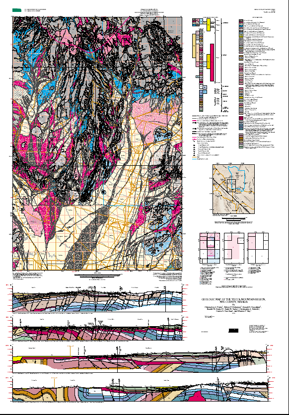
Yucca Mountain, Nye County, Nevada, has been identified as a
potential site for underground storage of high-level
radioactive waste. This geologic map compilation, including
all of Yucca Mountain and Crater Flat, most of the Calico
Hills, western Jackass Flats, Little Skull Mountain, the
Striped Hills, the Skeleton Hills, and the northeastern
Amargosa Desert, portrays the geologic framework for a
saturated-zone hydrologic flow model of the Yucca Mountain
site. Key geologic features shown on the geologic map and
accompanying cross sections include: (1) exposures of
Proterozoic through Devonian strata inferred to have been
deformed by regional thrust faulting and folding, in the
Skeleton Hills, Striped Hills, and Amargosa Desert near Big
Dune; (2) folded and thrust-faulted Devonian and Mississippian
strata, unconformably overlain by Miocene tuffs and lavas and
cut by complex Neogene fault patterns, in the Calico Hills; (3)
the Claim Canyon caldera, a segment of which is exposed north
of Yucca Mountain and Crater Flat; (4) thick densely welded to
nonwelded ash-flow sheets of the Miocene southwest Nevada
volcanic field exposed in normal-fault-bounded blocks at Yucca
Mountain; (5) upper Tertiary and Quaternary basaltic cinder
cones and lava flows in Crater Flat and at southernmost Yucca
Mountain; and (6) broad basins covered by Quaternary and upper
Tertiary surficial deposits in Jackass Flats, Crater Flat, and
the northeastern Amargosa Desert, beneath which Neogene normal
and strike-slip faults are inferred to be present on the basis
of geophysical data and geologic map patterns.
A regional thrust belt of late Paleozoic or Mesozoic age
affected all pre-Tertiary rocks in the region; main thrust
faults, not exposed in the map area, are interpreted to
underlie the map area in an arcuate pattern, striking north,
northeast, and east. The predominant vergence of thrust faults
exposed elsewhere in the region, including the Belted Range and
Specter Range thrusts, was to the east, southeast, and south.
The vertical to overturned strata of the Striped Hills are
hypothesized to result from successive stacking of three south-
vergent thrust ramps, the lowest of which is the Specter Range
thrust. The CP thrust is interpreted as a north-vergent
backthrust that may have been roughly contemporaneous with the
Belted Range and Specter Range thrusts.
The southwest Nevada volcanic field consists predominantly of a
series of silicic tuffs and lava flows ranging in age from 15
to 8 Ma. The map area is in the southwestern quadrant of the
southwest Nevada volcanic field, just south of the Timber
Mountain caldera complex.
The Claim Canyon caldera, exposed in the northern part of the
map area, contains thick deposits of the 12.7-Ma Tiva Canyon
Tuff, along with widespread megabreccia deposits of similar
age, and subordinate thick exposures of other 12.8- to 12.7-Ma
Paintbrush Group rocks. An irregular, blocky fault array,
which affects parts of the caldera and much of the nearby area,
includes several large-displacement, steeply dipping faults
that strike radially to the caldera and bound south-dipping
blocks of volcanic rock.
South and southeast of the Claim Canyon caldera, in the area
that includes Yucca Mountain, the Neogene fault pattern is
dominated by closely spaced, north-northwest- to north-
northeast-striking normal faults that lie within a north-
trending graben. This 20- to 25-km-wide graben includes Crater
Flat, Yucca Mountain, and Fortymile Wash, and is bounded on the
east by the "gravity fault" and on the west by the Bare
Mountain fault. Both of these faults separate Proterozoic and
Paleozoic sedimentary rocks in their footwalls from Miocene
volcanic rocks in their hanging walls.
Stratigraphic and structural relations at Yucca Mountain
demonstrate that block-bounding faults were active before and
during eruption of the 12.8- to 12.7-Ma Paintbrush Group, and
significant motion on these faults continued until after the
11.6-Ma Rainier Mesa Tuff was deposited. North of Crater Flat,
in and near the Claim Canyon caldera, most of the tilting of
the volcanic section predated the 11.6-Ma Rainier Mesa Tuff.
In contrast, geologic relations in central and southern Yucca
Mountain indicate that much of the stratal tilting there
occurred after 11.6 Ma, probably synchronous with the main
pulse of vertical-axis rotation that occurred between 11.6 and
11.45 Ma.
Beneath the broad basins, such as Crater Flat, Jackass Flats,
and the Amargosa Desert, faults are inferred from geophysical
data. Geologic and geophysical data imply the presence of the
large-offset, east-west-striking Highway 95 fault beneath
surficial deposits along the northeast margin of the Amargosa
Desert, directly south of Yucca Mountain and Crater Flat. The
Highway 95 fault is interpreted to be downthrown to the north,
with a component of dextral displacement. It juxtaposes a
block of Paleozoic carbonate rock overlain by a minimal
thickness of Tertiary rocks (to the south) against the Miocene
volcanic section of Yucca Mountain (to the north).
Alluvial geomorphic surfaces compose the bulk of Quaternary
surficial units in the Yucca Mountain region. Deposits
associated with these surfaces include alluvium, colluvium, and
minor eolian and debris-flow sediments. Photogeologic and
field studies locally have identified subtle fault scarps that
offset these surfaces, and other evidence of Quaternary fault
activity.
Purpose:
This geologic map was constructed to provide the structural and
stratigraphic framework for a saturated-zone groundwater model
for the Yucca Mountain Project site area.
Supplemental_Information:
Topographic base from these U.S. Geological Survey 1:24,000-
scale digital line graph (DLG) quadrangles: East of Beatty
Mountain, Topopah Spring NW, Topopah Spring, Jackass Flats,
Striped Hills, Crater Flat, Busted Butte, Big Dune, Amargosa
Valley, South of Amargosa Valley, Ashton, Beatty Mountain,
Carrara Canyon, Lees Camp, Leeland, Skeleton Hills. 50,000-ft
grid based on Nevada State Plane coordinates. Contour interval
is 40 ft. DLG's were clipped to fit into the area of interest.
Township and Range boundaries from U.S. Geological Survey 1:
100,000-scale Digital Line Graph data for the Beatty
quadrangle.
Roads are from the DOE/OCRWM/YMSCO database, coverage ROADNYES,
reference G97558, based on U.S. Census Bureau, 1:100,000-scale
TIGER data for Nye County, Nevada.
Theme:
Theme_Keyword_Thesaurus: USGS Thesaurus
Theme_Keyword: geology
Theme_Keyword: geologic maps
Theme_Keyword: geologic structure
Theme_Keyword: tectonic processes
Theme_Keyword: bedrock geologic units
Theme_Keyword: faulting (geologic)
Theme_Keyword: geospatial datasets
Theme:
Theme_Keyword_Thesaurus: none
Theme_Keyword: Neogene extensional faults
Theme_Keyword: Neogene strike-slip faults
Theme_Keyword: pre-Tertiary thrust faults
Theme_Keyword: Miocene calderas
Theme_Keyword: southwest Nevada volcanic field
Theme_Keyword: nonmarine sedimentary basins
Theme_Keyword: Tertiary and Quaternary basins
Theme_Keyword: Miocene densely welded tuffs
Theme_Keyword: Yucca Mountain Project
Theme_Keyword: U.S. Department of Energy
Theme_Keyword: U.S. Geological Survey
Theme_Keyword: caldera boundaries
Theme_Keyword: cross sections
Theme_Keyword: boreholes
Theme_Keyword: saturated-zone hydrologic flow model
Theme_Keyword: Claim Canyon caldera
Theme_Keyword: Timber Mountain caldera complex
Theme_Keyword: Belted Range thrust
Theme_Keyword: Specter Range thrust
Theme_Keyword: CP thrust
Theme_Keyword: gravity fault
Theme_Keyword: Highway 95 fault
Theme_Keyword: bedded tuffs
Theme:
Theme_Keyword_Thesaurus: ISO 19115 Topic Categories
Theme_Keyword: geoscientificInformation
Place:
Place_Keyword_Thesaurus:
U.S. Board on Geographic Names (BGN) Geographic Names Information System (GNIS)
Place_Keyword: Yucca Mountain
Place_Keyword: Nye County, Nevada
Place_Keyword: Crater Flat
Place_Keyword: Calico Hills
Place_Keyword: Jackass Flats
Place_Keyword: Little Skull Mountain
Place_Keyword: Striped Hills
Place_Keyword: Skeleton Hills
Place_Keyword: Amargosa Desert
Place_Keyword: Nevada Test Site
Place_Keyword: Black Marble
Place_Keyword: Fortymile Canyon
Place_Keyword: Shoshone Mountain
Place_Keyword: Chocolate Mountain
Place_Keyword: Comb Peak
Place_Keyword: Claim Canyon
Place_Keyword: Windy Wash
Place_Keyword: Prow Pass
Place_Keyword: Pinnacles Ridge
Place_Keyword: Beatty Wash
Place_Keyword: Dome Mountain
Place_Keyword: Rock Valley
Place_Keyword: Steve's Pass
Place_Keyword: Lathrop Wells Cone
Place:
Place_Keyword_Thesaurus: Augmented FIPS 10-4 and FIPS 6-4
Place_Keyword: f32023 = Nye
Stratum:
Stratum_Keyword_Thesaurus: none
Stratum_Keyword: Tiva Canyon Tuff
Stratum_Keyword: Topopah Spring Tuff
Stratum_Keyword: Paintbrush Group
Stratum_Keyword: Yucca Mountain Tuff
Stratum_Keyword: Pah Canyon Tuff
Stratum_Keyword: rhyolite of Delirium Canyon
Stratum_Keyword: tuff of Pinyon Pass
Stratum_Keyword: rhyolite of Comb Peak
Stratum_Keyword: rhyolite of Vent Pass
Stratum_Keyword: rhyolite of Waterpipe Butte
Stratum_Keyword: rhyolite of Pinnacles Ridge
Stratum_Keyword: Beatty Wash Formation
Stratum_Keyword: lavas of Dome Mountain
Stratum_Keyword: rhyolite of Shoshone Mountain
Stratum_Keyword: basalt of Kiwi Mesa
Stratum_Keyword: Rocket Wash tuff
Stratum_Keyword: Lathrop Wells cinder cone
Stratum_Keyword: Timber Mountain Group
Stratum_Keyword: Ammonia Tanks Tuff
Stratum_Keyword: Rainier Mesa Tuff
Stratum_Keyword: rhyolite of Flourspar Canyon
Stratum_Keyword: rhyolite of Windy Wash
Stratum_Keyword: Tram Tuff
Stratum_Keyword: tuff of Yucca Flat
Stratum_Keyword: Lithic Ridge Tuff
Stratum_Keyword: older tuffs of USW-G1
Stratum_Keyword: Crater Flat Group
Stratum_Keyword: Bullfrog Tuff
Stratum_Keyword: Prow Pass Tuff
Stratum_Keyword: rhyolite of Prospector Pass
Stratum_Keyword: Wahmonie Formation
Stratum_Keyword: Calico Hills Formation
Stratum_Keyword: Johnnie Formation
Stratum_Keyword: Carrara Formation
Stratum_Keyword: Bonanza King Formation
Stratum_Keyword: Nopah Formation
Stratum_Keyword: Pogonip Group
Stratum_Keyword: Eureka Quartzite
Stratum_Keyword: Ely Springs Dolomite
Stratum_Keyword: Lone Mountain Dolomite
Stratum_Keyword: Roberts Mountains Formation
Stratum_Keyword: rocks of Calico Mines
Stratum_Keyword: Eleana Formation
Stratum_Keyword: Chainman Shale
Stratum_Keyword: rocks of Pavits Spring
Stratum_Keyword: rocks of Winapi Wash
Stratum_Keyword: Quaternary basalts
Stratum_Keyword: Basin and Range province
Stratum_Keyword: Walker Lane belt
Stratum_Keyword: Windy Wash fault
Stratum_Keyword: Solitario Canyon fault
Stratum_Keyword: Iron Ridge fault
Stratum_Keyword: Paintbrush Canyon fault
Stratum_Keyword: Bare Mountain fault
Stratum_Keyword: Stagecoach Road fault
Temporal:
Temporal_Keyword_Thesaurus: none
Temporal_Keyword: Tertiary
Acknowledgment of the U.S. Geological Survey would be appreciated
in products derived from these data.
Bedrock geology mapped by Christopher J. Potter, Robert P. Dickerson, Donald S. Sweetkind, Ronald M. Drake II, Christopher J. Fridrich, and Warren C. Day, 1997-1998, and compiled from data sources cited below. Surficial geology mapped by Emily M. Taylor in 1998, and compiled from data sources cited below. Geologic contacts and faults digitized by Ronald M. Drake II, Carma A. San Juan, and Emily M. Taylor.