Citation:
Citation_Information:
Originator: DeWitt, Ed
Originator: Zech, R.S.
Originator: Chase, C.G.
Originator: Zartman, R.E.
Originator: Kucks, R.P.
Originator: Bartelson, Bruce
Originator: Rosenlund, G.C.
Originator: Early, III, Drummond
Publication_Date: 2002
Title:
Geologic and aeromagnetic maps of the Fossil Ridge
area and vicinity, Gunnison County, Colorado
Geospatial_Data_Presentation_Form: vector digital data
Series_Information:
Series_Name: U.S. Geological Survey Geologic Investigations Series
Issue_Identification: I-2738
Online_Linkage: http://pubs.usgs.gov/imap/i-2738/
Description:
Abstract:
This data set includes a GIS geologic map database of an Early
Proterozoic metavolcanic and metasedimentary terrane
extensively intruded by Early and Middle Proterozoic granitic
plutons. Laramide to Tertiary deformation and intrusion of
felsic plutons have created numerous small mineral deposits
that are described in the tables and are shown on the figures
in the accompanying text pamphlet. Also included in the
pamphlet are numerous chemical analyses of igneous and meta-
igneous bodies of all ages in tables and in summary geochemical
diagrams. The text pamphlet also contains a detailed
description of map units and discussions of the aeromagnetic
survey, igneous and metmorphic rocks, and mineral deposits. The
printed map sheet and browse graphic pdf file include the
aeromagnetic map of the study area, as well as figures and
photographs.
Purpose:
This GIS geologic map database is provided to facilitate the
presentation and analysis of earth-science data for this region
of Colorado. This digital map database may be displayed at any
scale or projection. However, the geologic data in this
coverage are not intended for use at a scale other than 1:30,
000. Supplemental useful data accompanying the database are
extensive geochemical and mineral deposits data, as well as an
aeromagnetic map.
Supplemental_Information:
Files:
geo_poly.e00    stratigraphic contacts and geologic units
geo_line.e00    structural features such as dikes and faults
geo_pnt.e00     structural orientations, and sample localities
neatline.e00    neatline border for map
graphics.e00    graphic representations of point symbols
rfossil1112.tif Topographic base map image
rfossil1112.tfw Topographic image georeference information
Data_Set_Structure:
Data_Set_Part:
Part_Name: geo_poly.e00
Part_Type: coverage
Part_Description: arc and poly coverage of stratigraphic contacts and geologic units
Data_Set_Part:
Part_Name: geo_line.e00
Part_Type: coverage
Part_Description: arc coverage containing linear features, such as dikes and faults
Data_Set_Part:
Part_Name: geo_pnt.e00
Part_Type: coverage
Part_Description: point and annotation coverage showing point symbols: strike and dip of bedding, strike and dip of foliation and joints, and sample localities
Data_Set_Part:
Part_Name: neatline.e00
Part_Type: coverage
Part_Description: neatline border for map
Data_Set_Part:
Part_Name: graphics.e00
Part_Type: coverage
Part_Description: graphic file showing accurate graphic representations of point symbols
Data_Set_Part:
Part_Name: rfossil1112.tif and .tfw
Part_Type: image and georeference information
Part_Description: Topographic base map information
Time_Period_of_Content:
Time_Period_Information:
Single_Date/Time:
Calendar_Date: 2002
Currentness_Reference: publication date
Status:
Progress: Complete
Maintenance_and_Update_Frequency: Unknown
Spatial_Domain:
Bounding_Coordinates:
West_Bounding_Coordinate: -106.75
East_Bounding_Coordinate: -106.46
North_Bounding_Coordinate: 38.79
South_Bounding_Coordinate: 38.59
Keywords:
Theme:
Theme_Keyword_Thesaurus: USGS Thesaurus
Theme_Keyword: geologic maps
Theme_Keyword: bedrock geologic units
Theme_Keyword: geologic structure
Theme_Keyword: geospatial datasets
Theme_Keyword: geology
Theme_Keyword: geochemistry
Theme_Keyword: mineral resources
Theme_Keyword: geochronology
Theme_Keyword: magnetic field (earth)
Theme_Keyword: magnetic susceptibility
Theme:
Theme_Keyword_Thesaurus: ISO 19115 Topic Categories
Theme_Keyword: geoscientificInformation
Place:
Place_Keyword_Thesaurus: none
Place_Keyword: Fossil Ridge area
Place_Keyword: Colorado
Place_Keyword: Sawatch uplift
Place_Keyword: Gunnison County
Place_Keyword: Sawatch Range
Place:
Place_Keyword_Thesaurus: Augmented FIPS 10-4 and FIPS 6-4
Place_Keyword: f08051 = Gunnison
Access_Constraints: None
Use_Constraints: None
Point_of_Contact:
Contact_Information:
Contact_Organization_Primary:
Contact_Organization: U.S. Geological Survey
Contact_Person: DeWitt, Ed
Contact_Position: Geologist
Contact_Address:
Address_Type: mailing and physical address
Address: Minerals, MS 905 Denver Federal Center
City: Denver
State_or_Province: CO
Postal_Code: 80225
Country: USA
Contact_Voice_Telephone: 303-236-5636
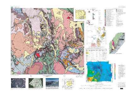
Browse_Graphic:
Browse_Graphic:
Browse_Graphic_File_Name: http://pubs.usgs.gov/imap/i-2738/i-2738.pdf
Browse_Graphic_File_Description:
Browse graphic shows the geologic map, aeromagnetic map,
correlation of map units, description of map units, tabular
data, figures showing mineral deposits, color photographs, and
index map, 10 megabytes
Browse_Graphic_File_Type: PDF
Data_Set_Credit:
Geology mapped by Ed DeWitt, R.S. Zech, C.G. Chase, Bruce
Bartleson, C.G. Rosenlund, and Drummond Early III.
Geochronology by Ed DeWitt and R.E. Zartman.
Geophysics by R.A. Martin, Bob Kucks, and Ed DeWitt.
The ArcInfo database was created by RedZone Software. ArcInfo
database reviewed by Nancy Shock, who also prepared the ArcInfo
files for importing into Illustrator. The Adobe Illustrator
layout, which was used for the printed map and for the PDF browse
graphic, was prepared by Gayle Dumonceaux. Metadata file prepared
by F.C. Brunstein.
Native_Data_Set_Environment:
Data set was created using ESRI ArcInfo version 7 on a Unix platform