Digital spatial data for the map "Earthquakes in and near the northeastern United States, 1638-1998"

Metadata also available as - [Outline] - [Parseable text] - [XML]

Frequently anticipated questions:


What does this data set describe?

Title:
Digital spatial data for the map "Earthquakes in and near the northeastern United States, 1638-1998"
Abstract:
The data are those used to make a large-format, colored map of earthquakes in the northeastern United States and adjacent parts of Canada and the Atlantic Ocean (Wheeler, 2000; Wheeler and others, 2001; references in Data_Quality_Information, Lineage). The map shows the locations of 1,069 known earthquakes of magnitude 3.0 or larger, and is designed for a non-technical audience. Colored circles represent earthquake locations, colored and sized by magnitude. Short descriptions, colonial-era woodcuts, newspaper headlines, and photographs summarize the dates, times of day, damage, and other effects of notable earthquakes. The base map shows color-coded elevation, shaded to emphasize relief.
Supplemental_Information:
This metadata record describes the data on earthquakes and topography. Other data, such as for roads and urban areas, were obtained elsewhere and we lack metadata for them. Instead, this field cites the sources of these data that were obtained elsewhere.
  1. How might this data set be cited?
    Wheeler, Russell L., 2001, Digital spatial data for the map "Earthquakes in and near the northeastern United States, 1638-1998": U.S. Geological Survey Geologic Investigations Series I-2737.

    Online Links:

  2. What geographic area does the data set cover?
    West_Bounding_Coordinate: -81.0
    East_Bounding_Coordinate: -66.0
    North_Bounding_Coordinate: 48.0
    South_Bounding_Coordinate: 38.0
  3. What does it look like?
    http://pubs.usgs.gov/imap/i-2737//i-2737.gif (GIF)
    Greatly reduced image of map sheet (288x209 pixels, 39k bytes).
    http://pubs.usgs.gov/imap/i-2737//i-2737.pdf (PDF)
    Graphic representation of map layout, full resolution, 16 megabytes.
  4. Does the data set describe conditions during a particular time period?
    Beginning_Date:
    Ending_Date: 29-Dec-1998
    Currentness_Reference:
    All known earthquakes of magnitude m(b) 3.0 or larger in the map area through 19981231. Earthquake compilation for different parts of map area was completed at different times between 20000424 and 20000628.
  5. What is the general form of this data set?
    Geospatial_Data_Presentation_Form: map
  6. How does the data set represent geographic features?
    1. How are geographic features stored in the data set?
      This is a Point data set. It contains the following vector data types (SDTS terminology):
      • Point (1069)
    2. What coordinate system is used to represent geographic features?
      Horizontal positions are specified in geographic coordinates, that is, latitude and longitude. Latitudes are given to the nearest 0.0001. Longitudes are given to the nearest 0.0001. Latitude and longitude values are specified in Decimal degrees. The horizontal datum used is NAD 1927.
      The ellipsoid used is Clarke 1866.
      The semi-major axis of the ellipsoid used is 6,378,206.4.
      The flattening of the ellipsoid used is 1/294.98.
  7. How does the data set describe geographic features?
    NEEQ00.PAT
    Point attribute table (Source: ArcINFO 7.2.1)
    YR
    Year of earthquake occurrence (Source: Wheeler (2000))
    Range of values
    Minimum:1638
    Maximum:1998
    Units:year
    Resolution:1
    MO
    Month of earthquake occurrence (Source: Wheeler (2000))
    Range of values
    Minimum:01
    Maximum:12
    Units:month
    Resolution:1
    DY
    Day of earthquake occurrence (Source: Wheeler (2000))
    Range of values
    Minimum:01
    Maximum:31
    Units:day
    Resolution:1
    X
    Epicentral longitude (Source: Wheeler (2000))
    Range of values
    Minimum:-81.000
    Maximum:-66.100
    Units:deg
    Resolution:0.0001
    Y
    Epicentral latitude (Source: Wheeler (2000))
    Range of values
    Minimum:38.000
    Maximum:47.998
    Units:deg
    Resolution:0.0001
    MAG
    Magnitude of earthquake occurrence (Source: Wheeler (2000))
    Range of values
    Minimum:3.0
    Maximum:7.0
    Units:magnitude unit
    Resolution:0.1
    REF
    Reference code (Source: Wheeler (2000))
    Formal codeset
    Codeset Name:Reference Codes
    Codeset Source:Reference code list is found in http://pubs.usgs.gov/imap/i-2737/catalog_txt.zip
    STATE
    State/Country code (Source: Wheeler (2000))
    ValueDefinition
    AT100-300 km (60-200 mi) offshore in Atlantic Ocean
    CNCanada
    CTConnecticut
    DLDelaware
    MAMassachusetts
    MDMaryland
    MEMaine
    NHNew Hampshire
    NJNew Jersey
    NYNew York
    OHOhio
    PAPennsylvania
    RIRhode Island
    VAVirginia
    VTVermont
    WVWest Virginia

Who produced the data set?

  1. Who are the originators of the data set? (may include formal authors, digital compilers, and editors)
    • Russell L. Wheeler
  2. Who also contributed to the data set?
    The map and parts of the earthquake descriptions and catalog were improved by suggestions and data from John Adams, Shelton Alexander, John Armbruster, Stefanie Baxter, Martin Chapman, Edward Cranswick, Pamela Detra, James Dewey, Charles Doll, Daniel Dombroski, Jr., Janet Drysdale, John Ebel, Rodger Faill, Robert Fakundiny, Edward Fratto, Stephen Halchuk, Michael Hansen, Klaus Jacob, Alan Kafka, Won-Young Kim, John Lahr, Kathleen Langone, Charles Langston, Nancy McHone, Stuart Nishenko, Gary Nottis, James Reger, Charles Scharnberger, Leonardo Seeber, and Nafi Toksoz.
  3. To whom should users address questions about the data?
    Russell L. Wheeler
    U.S. Geological Survey
    geologist
    P.O. Box 25046, M.S. 966
    Denver, Colorado
    USA

    (303) 273-8589 (voice)
    (303) 273-8600 (FAX)
    wheeler@usgs.gov
    Hours_of_Service: normal weekday working hours

Why was the data set created?

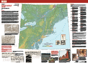
The map is an educational tool with which to inform the public about the existence and the broad, regional nature of earthquake hazard in the Northeast. The data were created digitally in order to ease and speed production and publication of the map. Text on the map cautions against using the map for scientific or engineering purposes, or to estimate hazard in small areas or at single sites. Entries in Lineage under Data_Quality_Information explain the reasons for this caution (see also Wheeler, 2000; reference in Lineage).
The earthquake catalog was constructed in such a way that it should not be utilized in scientific, engineering, or hazards use ( Wheeler, 2000; reference in Lineage). Accordingly, the catalog is not being published separately, in order to minimize the potential for misuse. It is available only as part of the digital files from which the entire map was made.

How was the data set created?

  1. From what previous works were the data drawn?
    Wheeler (2000) (source 1 of 2)
    Wheeler, Russell L., 2000, Earthquakes of the northeastern United States and adjacent Canada, 1638-1998--Construction of the earthquake catalog for an outreach map: U.S. Geological Survey Open-File Report 00-0316, 6 p., U.S. Geological Survey, Denver, Colorado.

    Online Links:

    Other_Citation_Details:
    No existing earthquake catalog provided current, roughly uniform coverage of the map area. Instead, parts of the area are covered by two regional seismograph networks and the Canadian national network, and several states maintain or are compiling their own lists of earthquakes from various sources. Accordingly, making the map required compilation of a catalog. Because this map is designed for the public and not for scientific or engineering use, the map should show each state's earthquakes in a manner consistent with the way that state's authoritative persons or organizations show them. This principle of consistency with authoritative sources in each state was urged by one state geologist within the map area, and it was welcomed by members of other state geological surveys who were contacted during catalog construction. Accordingly, there are two main differences between this catalog and one that would result from a seismologist's research. First, I have not examined the original seismographic or intensity data. Second, the combination of sources used and the relative preference given to each source changed from State to State, and from Canada to the United States. Therefore, the map and its catalog should NOT be used for scientific or engineering purposes, nor to assess seismic hazards or losses. However, the map still shows the relative differences of seismicity between States and large parts of States. The larger damaging earthquakes have been vetted individually by local seismologists.
    Type_of_Source_Media: paper
    Source_Contribution: Procedures used in compiling the earthquake data set
    Wheeler and others (2001) (source 2 of 2)
    Russell L. Wheeler, Nathan K. Trevor, Arthur C. Tarr, and Anthony J. Crone, 2001, Earthquakes of the northeastern United States and adjacent Canada, 1638-1998: U.S. Geological Survey Geologic Investigations Series I-2737, U.S. Geological Survey, Reston, Virginia.

    Online Links:

    Other_Citation_Details: 1 sheet, scale 1:1,500,000
    Type_of_Source_Media: paper
    Source_Scale_Denominator: 1500000
    Source_Contribution: Earthquake data set plotted on source map
  2. How were the data generated, processed, and modified?
    Date: 29-Jun-2000 (process 1 of 9)
    Create point coverage neeq00xy Person who carried out this activity:
    Arthur C. Tarr
    USGS
    Computer Scientist
    USGS, MS 966, Denver Federal Center, Box 25046
    Denver, CO
    USA

    (303) 273-8570 (voice)
    (303) 273-8600 (FAX)
    atarr@usgs.gov
    Hours_of_Service: 8:00 - 4:30 Mountain Time
    Contact_Instructions: E-mail is preferred
    Date: 29-Jun-2000 (process 2 of 9)
    Build point attribute table Person who carried out this activity:
    Arthur C. Tarr
    USGS
    Computer Scientist
    USGS, MS 966, Denver Federal Center, Box 25046
    Denver, CO
    USA

    (303) 273-8570 (voice)
    (303) 273-8600 (FAX)
    atarr@usgs.gov
    Hours_of_Service: 8:00 - 4:30 Mountain Time
    Contact_Instructions: E-mail is preferred
    Date: 29-Jun-2000 (process 3 of 9)
    Generate x,y cordinates as attributes Person who carried out this activity:
    Arthur C. Tarr
    USGS
    Computer Scientist
    USGS, MS 966, Denver Federal Center, Box 25046
    Denver, CO
    USA

    (303) 273-8570 (voice)
    (303) 273-8600 (FAX)
    atarr@usgs.gov
    Hours_of_Service: 8:00 - 4:30 Mountain Time
    Contact_Instructions: E-mail is preferred
    Date: 29-Jun-2000 (process 4 of 9)
    Re-build point attribute table Person who carried out this activity:
    Arthur C. Tarr
    USGS
    Computer Scientist
    USGS, MS 966, Denver Federal Center, Box 25046
    Denver, CO
    USA

    (303) 273-8570 (voice)
    (303) 273-8600 (FAX)
    atarr@usgs.gov
    Hours_of_Service: 8:00 - 4:30 Mountain Time
    Contact_Instructions: E-mail is preferred
    Date: 29-Jun-2000 (process 5 of 9)
    Rename coverage to neeq00 Person who carried out this activity:
    Arthur C. Tarr
    USGS
    Computer Scientist
    USGS, MS 966, Denver Federal Center, Box 25046
    Denver, CO
    USA

    (303) 273-8570 (voice)
    (303) 273-8600 (FAX)
    atarr@usgs.gov
    Hours_of_Service: 8:00 - 4:30 Mountain Time
    Contact_Instructions: E-mail is preferred
    Date: 11-Jan-2001 (process 6 of 9)
    EXPORT coverage to neeq00.e00 Person who carried out this activity:
    Arthur C. Tarr
    USGS
    Computer Scientist
    USGS, MS 966, Denver Federal Center, Box 25046
    Denver, CO
    USA

    (303) 273-8570 (voice)
    (303) 273-8600 (FAX)
    atarr@usgs.gov
    Hours_of_Service: 8:00 - 4:30 Mountain Time
    Contact_Instructions: E-mail is preferred
    Date: 11-Jan-2001 (process 7 of 9)
    Create shapefiles Person who carried out this activity:
    Arthur C. Tarr
    USGS
    Computer Scientist
    USGS, MS 966, Denver Federal Center, Box 25046
    Denver, CO
    USA

    (303) 273-8570 (voice)
    (303) 273-8600 (FAX)
    atarr@usgs.gov
    Hours_of_Service: 8:00 - 4:30 Mountain Time
    Contact_Instructions: E-mail is preferred
    Date: 31-Jan-2001 (process 8 of 9)
    Complete metadata Person who carried out this activity:
    Arthur C. Tarr
    USGS
    Computer Scientist
    USGS, MS 966, Denver Federal Center, Box 25046
    Denver, CO
    USA

    (303) 273-8570 (voice)
    (303) 273-8600 (FAX)
    atarr@usgs.gov
    Hours_of_Service: 8:00 - 4:30 Mountain Time
    Contact_Instructions: E-mail is preferred
    Date: 15-Jan-2010 (process 9 of 9)
    Creation of original metadata record Person who carried out this activity:
    Russell L. Wheeler
    U.S. Geological Survey
    geologist
    P.O. Box 25046, M.S. 966
    Denver, Colorado
    USA

    (303) 273-8589 (voice)
    (303) 273-8600 (FAX)
    wheeler@usgs.gov
    Hours_of_Service: normal weekday working hours
  3. What similar or related data should the user be aware of?

How reliable are the data; what problems remain in the data set?

  1. How well have the observations been checked?
    No formal tests were devised for attribute accuracy of the earthquake epicentral parameters and magnitudes (other than checking transfer of values to the input data file) because attribute accuracy was best ascertained by individual contributors to the master catalog. See also Horizontal_Positional_Accuracy_Report.
  2. How accurate are the geographic locations?
    Accuracies of the earthquake locations vary with earthquake magnitude, date of occurrence, closeness to settled areas, and method used to calculate or estimate the location. Locations of modern earthquakes may be reported to the nearest 0.0001 degree and may be accurate to within several kilometers. Locations of earthquakes that predate the installation of seismographs may be known only to the nearest tenth or half a degree, or even to the nearest whole degree. All locations were taken from standard sources, and none were tested or modified.
  3. How accurate are the heights or depths?
    No depth information was included in the source table.
  4. Where are the gaps in the data? What is missing?
    Small or old earthquakes are more likely to have been missed than large or recent ones. Because limited resources required use of existing earthquake catalogs, the catalog compiled for the map may contain duplicates, omissions, and blasts or other nonseismic events. Text on the map explains these factors at greater length.
  5. How consistent are the relationships among the observations, including topology?
    Logical consistency checks were conducted during preparation of the map by visual examination of the positions of plotted symbols on the base map (searching for spurious locations) and cross-checking the tabular locations and magnitudes of the largest earthquakes against their graphical representation.

How can someone get a copy of the data set?

Are there legal restrictions on access or use of the data?
Access_Constraints: None
Use_Constraints: None
  1. Who distributes the data set? (Distributor 1 of 1)
    U.S. Geological Survey
    Central Publications Group
    Lakewood, CO
    USA

    303-236-5486 (voice)
  2. What's the catalog number I need to order this data set? USGS Geologic Investigations Series I-2737
  3. What legal disclaimers am I supposed to read?
    This earthquake catalog was compiled for educational and display purposes only, and should not be used for scientific, engineering, or hazards purposes. Reasons are described in text on the map, and in Wheeler (2000; reference in Lineage). Although these digital spatial data have been subjected to rigorous review and are substantially complete, they are released on the condition that neither the USGS nor the United States Government may be held liable for any damages resulting from their authorized or unauthorized use.
  4. How can I download or order the data?

Who wrote the metadata?

Dates:
Last modified: 13-Jun-2016
Last Reviewed: 31-Jan-2001
Metadata author:
Peter N Schweitzer
USGS Midwest Area
Collection manager, USGS Geoscience Data Clearinghouse, http://geo-nsdi.er.usgs.gov/
Mail Stop 954
12201 Sunrise Valley Dr
Reston, VA
USA

703-648-6533 (voice)
703-648-6252 (FAX)
pschweitzer@usgs.gov
Metadata standard:
Content Standard for Digital Geospatial Metadata (FGDC-STD-001-1998)

This page is <https://geo-nsdi.er.usgs.gov/metadata/map-i/2737/metadata.faq.html>
Generated by mp version 2.9.48 on Tue Jul 03 20:04:54 2018