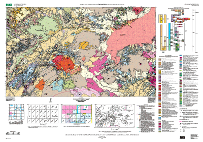
The dataset for the Tularosa Mountains quadrangle consists of six coverages:
tulgeop
tulflt
tulgline
tulgpnt
tuldpnt
tullndec
The coverage tullndec is not a "true" ARC/INFO coverage. It consists of various symbols drawn as arcs.
The tulgeop coverage consists of polygons that are map units and arcs that are contacts and color boundaries (other than contacts).
The tulgeop.pat INFO file consists of the following items:
TYPE--Refers to the type of polygon: in this database the only type in this coverage is "map unit." To interpret the map unit symbols, refer to the explanation of unit symbols as coded by NAME.
NAME--Refers to the map unit name and associated symbol.
Items in tulgeop.pat are defined as follows:
SURFICIAL DEPOSITS
Qa  Alluvium (Holocene)
Qsa  Playa alluvium of the Plains of San Agustin (Holocene)
Deposits of prehistoric lake San Agustin
Qsb  Bar and barrier ridge deposits (Holocene and Pleistocene)
Qsfd  Fan delta deposits (Holocene and Pleistocene)
Qss  Shoreline deposits (Holocene and Pleistocene)
Qac  Colluvium and alluvium (Holocene and Pleistocene)
Ql  Landslide deposits (Holocene and Pleistocene)
Qp  Piedmont slope deposits (Pleistocene)
VOLCANIC AND VOLCANICLASTIC ROCKS
Volcaniclastic rocks of the Gila Group
QTg   Gila Group, undivided (Pleistocene(?) to early Miocene)
QTgu  Upper Gila Group (Pleistocene(?) to middle Miocene)
QTgl  Lower Gila Group (middle to early Miocene)
QTs   Volcaniclastic rocks of the Santa Fe Group (Pleistocene to Miocene)
Volcanic rocks interlayered with the Gila Group
QTb   Basalt (Pleistocene and Pliocene, 0.9-2.5 Ma)
QTd   Basalt dikes (Pleistocene and Pliocene)
QTbc  Basalt scoria (Pleistocene and Pliocene)
Tb    Basalt, andesite, and dacite, undivided (Miocene)
Tbd   Basalt dikes (Miocene)
Tbcc  Basaltic scoria, cinders, and bombs (Miocene)
Tfb   Basalt on Flat Top Mesa (Miocene, 9 Ma) Rocks of Apache Peak volcano
Taa   Andesite at Apache Peak (Miocene, 10.6 Ma)
Rocks of Eagle Peak volcano
Tedp  Central dacite plug (Miocene, 11.4 Ma)
Tedu  Upper dacite flows (Miocene)
Tedl  Lower andesite and dacite flows (Miocene, 12 Ma)
Tedw  Wilson Canyon andesite flows (Miocene)
Tedm  Milligan Mountain andesite-dacite flows Miocene, 12 Ma)
Ted   Andesite dike at Dry Mesa (Miocene)
Rocks of Horse Mountain volcano
Thv   Predominantly dacitic, rhyolitic to andesitic lava flows  (Miocene, 12-14 Ma)
Thd   Northwest-trending, andesitic-dacitic breccia dikes (Miocene)
Tht   Pyroclastic rocks (Miocene)
Thp   Dacite plug (Miocene)
Thdr  Aplite dikes (Miocene)
Thb   Vent(?) breccia (Miocene)
Tha   Megacrystic andesite lava flow (Miocene, 12 Ma)
Tsb   Basalt of Saliz Hill (Miocene, 12.2 Ma)
Tkb   Basalt at Kiehnes Canyon (Miocene, 13.5 Ma)
Rocks of John Kerr Peak volcano
Tjr   Rhyolite domes and flows (Miocene,13 Ma)
Tmr   Rhyolite near Maverick Peak  (Miocene, 14 Ma)
Tmrd  Rhyolite dike in rhyolite near Maverick Peak (Miocene)
Tli   Porphyritic quartz-diorite intrusions at Wet Leggett Spring (Miocene,15 Ma)
Volcaniclastic rocks of the Spears Group (Oligocene and Eocene)
Tsu   Upper Spears Group (Oligocene)
Tsl   Lower Spears Group, undivided (Oligocene and Eocene)
Tslw  White sandstone sequence of lower Spears Group (Eocene)
Tslg  Green to gray sandstone sequence of lower Spears Group (Eocene)
Tpu   Upper Pueblo Creek Formation (Oligocene and Eocene)--Units Tt and Tt1-4 are discontinuous, thin (0 to about 5 m thick) Datil Group ignimbrites interlayered in upper Pueblo Creek Formation
Tpl   Lower Pueblo Creek Formation (Eocene)
Volcanic rocks of the Mogollon Group (Miocene and Oligocene)
Tmgu  Mogollon Group, undivided (Miocene and Oligocene)
Tad   Andesite dikes (Miocene and Oligocene)
Bearwallow Mountain Andesite (Oligocene, 25-26 Ma)
Tba   Basaltic-andesite to dacite lava flows (Oligocene)
Tbad  Andesitic dike (Oligocene)
Tbap  Andesite plugs (Oligocene)
Tbac  Andesitic cinder and scoria deposits(Oligocene)
Thr   Rhyolite of Hay Canyon (Oligocene?)
Tfr   Rhyolite at Frying Pan Creek (Oligocene?)
Tsr   Rhyolite of Stallings Tank (Oligocene)
Tct   Tuff of Triangle C Ranch (Oligocene, 28.1 Ma)
Tbt   Bloodgood Canyon Tuff (Elston, 1976)(Oligocene, 28.1 Ma)
Tca   Basaltic-andesite of Cottonwood Canyon (Oligocene)
Tst   Shelley Peak Tuff (Oligocene, 28.1 Ma)
Taylor Creek Rhyolite and associated rocks
Tgt   Tuff of Garcia Camp (Oligocene, 28.1 Ma)
Ttr   Taylor Creek Rhyolite (Oligocene, 28.1 Ma)
Tsa   Squirrel Springs Canyon Andesite(Oligocene, 28.5 Ma)
Tvt   Vicks Peak Tuff(Oligocene, 28.6 Ma)
Tgr   Rhyolite of Gwynn Canyon (Oligocene, 28.7 Ma)
Tlt   La Jencia Tuff (Oligocene, 28.9 Ma)
Tdt   Davis Canyon Tuff (Oligocene, 29.0 Ma)
Ta    Andesite flows (Oligocene)
Tbr   Rhyolite of Bat Cave Wells(Oligocene)
Rocks of Telephone Canyon volcano
Tta   Andesite of Telephone Canyon, undivided (Oligocene, 32.9-29.7 Ma)
Volcanic rocks of the Datil Group (Oligocene and Eocene)
Tdgu  Datil Group, undivided (Oligocene and Eocene)
Tcbt  Caballo Blanco Tuff(Oligocene, 31.6 Ma)
Thmt  Hells Mesa Tuff (Oligocene, 32.1 Ma)
Tt    Distal outflow of regional ignimbrites (Oligocene and Eocene)-- Labeled Tt-Tt4 where present in sequence
Rocks of Saddle Mountain volcano
Tas   Andesite lava flows (earliest Oligocene or latest Eocene, about 33.3 Ma)
Tasb  Andesite agglomerate (Oligocene or Eocene)
Tasd  Andesite dikes (Oligocene or Eocene)
Tsca  Andesitic intrusive-extrusive complex of Saliz Canyon (Eocene)
Tscb  Andesitic vent(?) breccia (Eocene, 33.6 Ma>
Tla   Andesite of Dry Leggett Canyon (Eocene)
Tlai  Possible plug or vent for andesite of Dry Leggett Canyon (Eocene)
Rocks of Horse Springs volcano or volcanic center
Thsd  Horse Springs dacite (Eocene, 33.7 Ma)
Thsb  Megabreccia and mesobreccia (Eocene)
Tbct  Blue Canyon Tuff (Eocene, 33.7 Ma)
Trt   Rock House Canyon Tuff (Eocene, 34.4 Ma)
Tbrt  Blue Canyon and Rock House Canyon Tuffs, undivided (Eocene)
Tlwt  Tuff of Lebya Well (Eocene, 34.7 Ma)
Tpt   Tuff of Bishop Peak (Eocene, 34.6 Ma)
Tkt   Kneeling Nun Tuff (Eocene, 34.9 Ma)
Tft   Tuff of Farr Ranch(Eocene, 35.6 Ma)
Twt   Datil Well Tuff (Eocene 35.5 Ma)
Twft  Datil Well Tuff and (or) tuff of Farr Ranch, undivided (Eocene)
Tac   Basaltic lava flow of Alamocito Canyon (Eocene)
OLDER SEDIMENTARY ROCKS
Sedimentary rocks, undivided (Permian)
The tulgeop.aat INFO file consists of the following items:
TYPE_L--Refers to the type of arc and is one of the following:
"contact" or "colorboundary."
ACCURACY--Refers to accuracy of location of arcs in the gpoly coverage and is one of the following: "certain" or "gradational" (used between facies of the Upper Pueblo Creek Formation).
The tulflt coverage consists of arcs that are faults.
The tulflt.aat INFO file consists of the following items:
TYPE--Refers to the type of arc; the only type in this coverage is "fault."
FAULTTYPE--Refers to the type of fault; the only type in this coverage is "normal."
ACCURACY--Refers to accuracy of location of arcs in the tulflt coverage
and is one of the following: "certain," "approximate," or "concealed."
DIPVALUE--Refers to amount of dip on fault, in degrees, where known; a value of 0 was arbitrarily entered in this field for faults where no dip was determined or known.
DIPDIRECTION--Refers to direction of dip on fault, where known, and is given as N (north), NE (northeast), E (east), SE (southeast), S (south), SW (southwest), W (west), or NW (northwest).
The tulgline coverage consists of arcs that are landslide scarps, caldera margins, tuffs, dikes, or fault/dikes (dikes that intrude faults).
The tulgline.aat INFO file consists of the following items:
TYPE--Refers to the type of arc and is one of the following: "dike," "fault/dike," "tuff," "landslide scarp," or "caldera margin."
ACCURACY--Refers to accuracy of location of caldera margin in the tulline coverage; the caldera margin is coded as "inferred."
NAME--Applicable only to "dike," "fault/dike," or "tuff" and refers to the map unit name or, in the case of an unnamed rhyolite dike, the symbol "rd."
Items in tulgline.aat are defined as follows:
Volcanic rocks interlayered with the Gila Group
QTd   Basalt dikes (Pleistocene and Pliocene)
Tbd   Basalt dikes (Miocene)
Rocks of Eagle Peak volcano
Ted   Andesite dike at Dry Mesa (Miocene)
Rocks of Horse Mountain volcano
Thd   Northwest-trending, andesitic-dacitic brecciadikes (Miocene)
Thdr  Aplite dikes (Miocene)
Rhyolite near Maverick Peak  (Miocene, 14 Ma)
Tmrd  Rhyolite dike in rhyolite near Maverick Peak (Miocene)
Volcanic rocks of the Mogollon Group (Miocene and Oligocene)
Tad   Andesite dikes (Miocene and Oligocene)
Bearwallow Mountain Andesite (Oligocene, 25-26 Ma)
Tbad  Andesite dike (Oligocene)
Volcanic rocks of the Datil Group (Oligocene and Eocene)
Tt    Distal outflow of regional ignimbrites (Oligocene and 	Eocene)-- Labeled Tt2-4 where present in sequence
Rocks of Saddle Mountain volcano
Tasd  Andesite dikes (Oligocene or Eocene)
Tpt   Tuff of Bishop Peak (Eocene, 34.6 Ma)
rd    Rhyolite dike (mapped only in Upper Pueblo Creek Formation and in Bloodgood Canyon Tuff)
The tulgpnt coverage consists of points that are localities of strike and dip measurements on sedimentary bedding surfaces and compaction foliation of ignimbrites (ash-flow tuffs); also includes locations
of volcanic centers or vents.
The tulgpnt.pat INFO file consists of the following items:
TYPE--Refers to the type of point or surface measured and is one of the following: "bedding surface," "foliation," or "volcanic center/vent."
DIPVALUE--Refers to the angle made by the intersection of the bedding surface or foliation with the horizontal; ranges from 0º to 90º
VOLCANICNUMBER--Refers to number assigned to a volcanic center or vent for descriptive purposes; volcanic centers and vents are numbered 1-26
POSITION--Refers to the attitude of measured surfaces and is one of the following: "inclined" or "horizontal."
ACCURACY--Refers to the accuracy of the strike and dip of surfaces and is one of the following: "measured" or "apparent."
SYMBOLANGLE--Refers to the rotation of the symbol used to plot the feature; NOT a measurement of actual orientation
of the feature (see STRIKEANGLE for the compass quadrant bearing).
STRIKEANGLE--Refers to the trend of a surface as it intersects the horizontal; recorded as compass
quadrant bearings, e.g., N66W
DIPDIRECTION--Refers to direction of dip of bedding surface or foliation, and is given as N (north), NE (northeast), E (east), SE (southeast), S (south), SW (southwest), W (west), or NW (northwest).
VOLCANICAGE--Refers to the age of the volcanic center or vent in millions of years (Ma), where determined.
The tuldpnt coverage consists of points that are locations of test wells and road metal quarries.
The tuldpnt.pat INFO file consists of the following items:
GEOCODE--Refers to the type of point and is one of the following: "oil well," "climate well," or "quarry."
NAME--Gives the full name of the well, either "SWEPI No. 1 oil test well" or "600-m Oberlin University climate test well."
The tullndec coverage consists of arcs that are line decorations: bar and ball symbols that show displacement on faults, arrows that show dip direction on faults, and arrows used to indicate the gradational contact between facies of the upper Pueblo Creek Formation of the Spears Group (annotations: AF, alluvial facies; VF, vent facies).
The tullndec.aat INFO file consists of the following items:
DIPVALUE--Refers to amount of dip on fault, in degrees, where known; a value of 0 was arbitrarily entered in this field for faults where no dip was determined or known.
DIPDIRECTION--Refers to direction of dip of a fault, and is given as N (north), NE (northeast), E (east), SE (southeast), S (south), SW (southwest), W (west), or NW (northwest).