Quaternary Geologic Map of the Lake Superior 4° x 6° Quadrangle, United States and Canada

Metadata also available as - [Questions & Answers] - [Parseable text] - [XML]

Metadata:

Identification_Information:
Citation:
Citation_Information:
Originator: Gerald M. Richmond (ed.)
Originator: David S. Fullerton (ed.)
Originator: William R. Farrand (comp.)
Originator: David M. Mickelson (comp.)
Originator: W. Richard Cowan (comp.)
Originator: Joseph E. Goebel (comp.)
Publication_Date: 2001
Title:
Quaternary Geologic Map of the Lake Superior 4° x 6° Quadrangle, United States and Canada
Edition: 1.1
Geospatial_Data_Presentation_Form: map
Series_Information:
Series_Name: U.S. Geological Survey Miscellaneous Investigations Series
Issue_Identification: I-1420 (NL-16)
Publication_Information:
Publication_Place: Denver, Colorado
Publisher: U.S. Geological Survey
Online_Linkage: http://pubs.usgs.gov/imap/i-1420/nl-16/
Larger_Work_Citation:
Citation_Information:
Originator: U.S. Geological Survey
Publication_Date: 1983-
Title: Quaternary geologic atlas of the United States
Geospatial_Data_Presentation_Form: map
Series_Information:
Series_Name: U.S. Geological Survey Miscellaneous Investigations Series
Issue_Identification: I-1420
Publication_Information:
Publication_Place: Denver, Colorado
Publisher: U.S. Geological Survey

Description:
Abstract:
The Quaternary Geologic Map of the Lake Superior 4° x 6° Quadrangle was mapped as part of the Quaternary Geologic Atlas of the United States. The atlas was begun as an effort to depict the areal distribution of surficial geologic deposits and other materials that accumulated or formed during the past 2+ million years, the period that includes all activities of the human species. These materials are at the surface of the earth. They make up the "ground" on which we walk, the "dirt" in which we dig foundations, and the "soil" in which we grow crops. Most of our human activity is related in one way or another to these surface materials that are referred to collectively by many geologists as regolith, the mantle of fragmental and generally unconsolidated material that overlies the bedrock foundation of the continent. The maps were compiled at 1:1,000,000 scale.
Purpose:
In recent years, surficial deposits and materials have become the focus of much interest by scientists, environmentalists, governmental agencies, and the general public. They are the foundations of ecosystems, the materials that support plant growth and animal habitat, and the materials through which travels much of the water required for our agriculture, our industry, and our general well being. They also are materials that easily can become contaminated by pesticides, fertilizers, and toxic wastes. In this context, the value of the surficial geologic map is evident
The description of map units and sources of information are both included as text files.
Supplemental_Information:
The digital file was prepared at 1:1,000,000 nominal viewing scale. If the map is enlarged to larger scales (for example, 1:250,000, 1:100,000, or 1:24,000 scale), resolution of the map data is greatly diminished. Enlargement will not restore resolution that was lost by simplification or generalization of data.
This database represents an attempt to digitally capture all the geologic information available on the published paper map. Separate coverages are provided for the map unit polygons, linear glacial features, point data for drumlins and type localities, important stratigraphic sections, and line coverages for the hydrology and topography.
The published maps of the Quaternary Geologic Atlas of the U.S. used three separate projections. To promote uniformity, the projection of this database was changed from Lambert Conformal Conic to Albers Equal Area and all subsequent digital databases will similarly be changed to Albers Equal Area Projection.
Illustrations are provided showing loess distribution and thickness, relationships of the late Wisconsin glacial lobes, sublobes, and advances within lobes and sublobes, and areas of responsibility for the compilation of the map. An illustration is provided showing the correlation of map units.
Any use of trade, product, or firm names is for descriptive purposes only and does not imply endorsement by the U.S. Government.
Although this Federal Geographic Data Committee-compliant metadata file is intended to document the data set in nonproprietary form, as well as in ARC/INFO format, this metadata file includes some ARC/INFO-specific terminology.
The dataset for the Lake Superior quadrangle consists of 10 coverages.
       geo_net
       gla_lin
       gla_pnt
       hydr_lin
       topo_lin
       bnd_lin
       bnd_net
       rd_lin
       rr_lin
       grid_lin

The dataset also includes an ARC/INFO AML, lineset, shadeset, and markerset that will produce the EPS file of the geology and glacial features and the list of map units.
Time_Period_of_Content:
Time_Period_Information:
Range_of_Dates/Times:
Beginning_Date: 1978
Ending_Date: 1980
Currentness_Reference: Publication date
Status:
Progress: Complete
Maintenance_and_Update_Frequency: None Planned

Spatial_Domain:
Bounding_Coordinates:
West_Bounding_Coordinate: -90.00
East_Bounding_Coordinate: -84.00
North_Bounding_Coordinate: 48.00
South_Bounding_Coordinate: 44.00

Keywords:
Theme:
Theme_Keyword_Thesaurus: USGS Thesaurus
Theme_Keyword: geology
Theme_Keyword: geologic maps
Theme_Keyword: surficial geologic units
Theme_Keyword: geospatial datasets
Theme_Keyword: unconsolidated deposits
Theme_Keyword: Quaternary
Theme:
Theme_Keyword_Thesaurus: American Geological Institute (AGI) Glossary of Geology
Theme_Keyword: Alluvium
Theme_Keyword: Beach deposits
Theme_Keyword: Coastal deposits
Theme_Keyword: Colluvium
Theme_Keyword: Decomposition residuum
Theme_Keyword: Delta
Theme_Keyword: Dune
Theme_Keyword: Eolian deposits
Theme_Keyword: Genesis
Theme_Keyword: Geologic history
Theme_Keyword: Geologic map
Theme_Keyword: Geology
Theme_Keyword: Glacial deposits
Theme_Keyword: Glacial limits
Theme_Keyword: Glaciofluvial deposits
Theme_Keyword: Glaciotectonic deposits
Theme_Keyword: Holocene
Theme_Keyword: Ice-contact deposits
Theme_Keyword: Lacustrine deposits
Theme_Keyword: Marine deposits
Theme_Keyword: Marsh deposits
Theme_Keyword: Moraine
Theme_Keyword: Outwash deposits
Theme_Keyword: Quaternary
Theme_Keyword: Quaternary geology
Theme_Keyword: Regional geology
Theme_Keyword: Residuum
Theme_Keyword: Sand deposits
Theme_Keyword: Saprolite
Theme_Keyword: Sedimentary rocks
Theme_Keyword: Solifluction deposits
Theme_Keyword: Surficial deposits
Theme_Keyword: Surficial geology
Theme_Keyword: Swamp deposits
Theme_Keyword: Till
Theme:
Theme_Keyword_Thesaurus: ISO 19115 Topic Categories
Theme_Keyword: geoscientificInformation
Place:
Place_Keyword_Thesaurus: U.S. Board on Geographic Names (BGN)
Place_Keyword: Canada
Place_Keyword: Great Lakes
Place_Keyword: Lake Michigan
Place_Keyword: Lake Superior
Place_Keyword: Michigan
Place_Keyword: Minnesota
Place_Keyword: Ontario
Place_Keyword: United States
Place_Keyword: Wisconsin
Place:
Place_Keyword_Thesaurus: Augmented FIPS 10-4 and FIPS 6-4
Place_Keyword: f27031 = Cook
Place_Keyword: f55051 = Iron
Place_Keyword: f55125 = Vilas
Place_Keyword: f55041 = Forest
Place_Keyword: f55037 = Florence
Place_Keyword: f55099 = Price
Place_Keyword: f55085 = Oneida
Place_Keyword: f55075 = Marinette
Place_Keyword: f55069 = Lincoln
Place_Keyword: f55067 = Langlade
Place_Keyword: f55119 = Taylor
Place_Keyword: f55083 = Oconto
Place_Keyword: f55029 = Door
Place_Keyword: f55073 = Marathon
Place_Keyword: f55078 = Menominee
Place_Keyword: f55115 = Shawano
Place_Keyword: f55097 = Portage
Place_Keyword: f55141 = Wood
Place_Keyword: f55009 = Brown
Place_Keyword: f55135 = Waupaca
Place_Keyword: f55061 = Kewaunee
Place_Keyword: f55087 = Outagamie
Place_Keyword: f55071 = Manitowoc
Place_Keyword: f55057 = Juneau
Place_Keyword: f55001 = Adams
Place_Keyword: f55137 = Waushara
Place_Keyword: f55139 = Winnebago
Place_Keyword: f55015 = Calumet
Place_Keyword: f26003 = Alger
Place_Keyword: f26009 = Antrim
Place_Keyword: f26011 = Arenac
Place_Keyword: f26013 = Baraga
Place_Keyword: f26019 = Benzie
Place_Keyword: f26029 = Charlevoix
Place_Keyword: f26031 = Cheboygan
Place_Keyword: f26033 = Chippewa
Place_Keyword: f26035 = Clare
Place_Keyword: f26039 = Crawford
Place_Keyword: f26041 = Delta
Place_Keyword: f26043 = Dickinson
Place_Keyword: f26047 = Emmet
Place_Keyword: f26051 = Gladwin
Place_Keyword: f26053 = Gogebic
Place_Keyword: f26055 = Grand Traverse
Place_Keyword: f26061 = Houghton
Place_Keyword: f26071 = Iron
Place_Keyword: f26079 = Kalkaska
Place_Keyword: f26083 = Keweenaw
Place_Keyword: f26085 = Lake
Place_Keyword: f26089 = Leelanau
Place_Keyword: f26095 = Luce
Place_Keyword: f26097 = Mackinac
Place_Keyword: f26101 = Manistee
Place_Keyword: f26103 = Marquette
Place_Keyword: f26105 = Mason
Place_Keyword: f26113 = Missaukee
Place_Keyword: f26119 = Montmorency
Place_Keyword: f26129 = Ogemaw
Place_Keyword: f26131 = Ontonagon
Place_Keyword: f26133 = Osceola
Place_Keyword: f26135 = Oscoda
Place_Keyword: f26137 = Otsego
Place_Keyword: f26141 = Presque Isle
Place_Keyword: f26143 = Roscommon
Place_Keyword: f26153 = Schoolcraft
Place_Keyword: f26165 = Wexford
Temporal:
Temporal_Keyword_Thesaurus:
Richmond, G.M., and Fullerton, D.S., eds., 1986, Introduction, in Quaternary glaciations in the United States of America: Quaternary Science Reviews, v. 5.
Temporal_Keyword: Early Wisconsin
Temporal_Keyword: Holocene
Temporal_Keyword: Late Wisconsin
Temporal_Keyword: Pleistocene
Temporal_Keyword: Pre-Wisconsin
Temporal_Keyword: Quaternary
Temporal_Keyword: Tertiary
Temporal_Keyword: Wisconsin

Access_Constraints: None
Use_Constraints:
Acknowledgment of the Quaternary Geologic Atlas of the United States of America and (or) the U.S. Geological Survey in products derived from these data will be appreciated.
Point_of_Contact:
Contact_Information:
Contact_Person_Primary:
Contact_Person: Charles A. Bush
Contact_Organization: U.S. Geological Survey
Contact_Position: Emeritus Geophysicist
Contact_Address:
Address_Type: Mailing and physical address
Address: Mail Stop 913, Box 25046, Federal Center
City: Lakewood
State_or_Province: Colorado
Postal_Code: 80225
Country: USA
Contact_Voice_Telephone: (303) 236-4723
Contact_Facsimile_Telephone: (303) 236-0214
Contact_Electronic_Mail_Address: cbush@usgs.gov

Browse_Graphic:
Browse_Graphic_File_Name: http://pubs.usgs.gov/imap/i-1420/nl-16/I-1420_nl-16_screen.gif
Browse_Graphic_File_Description:
Reduced-size image of the entire map sheet; 450x350 pixels 32-bit RGB truecolor, 82k bytes.
Browse_Graphic_File_Type: GIF
Browse_Graphic:
Browse_Graphic_File_Name: http://pubs.usgs.gov/imap/i-1420/nl-16/I-1420_nl-16_print.pdf
Browse_Graphic_File_Description:
Scan of the original published paper map optimized for printing.
Browse_Graphic_File_Type: PDF

Data_Set_Credit:
Quaternary Geologic Map of the Lake Superior 4° x 6° Quadrangle, United States and Canada, I-1420 (NL-16) was compiled by William R. Farrand, Department of Geological Sciences, University of Michigan; David M. Mickelson, Department of Geology and Geophysics, University of Wisconsin; W. Richard Cowan, Ontario Department of Natural Resources; and Joseph E. Goebel, Minnesota Geological Survey; the state and province compilations were edited and integrated by Gerald M. Richmond, and David S. Fullerton, U.S. Geological Survey. The compilations of geology and glacial features were converted to digital form by Techni Graphic Systems, Inc., of Fort Collins, CO, under contract with the U.S. Geological Survey and modified by Charles A. Bush. Illustrations, word processor files and DLG coverages were prepared by Charles A. Bush and Christy E. Briles, U.S. Geological Survey. Hydrography and topography coverages were scanned and vectorized by C.A. Bush and C.E. Briles.
Native_Data_Set_Environment:
Windows_NT, 4.0, Intel ARC/INFO version 7.2.1
Data_Quality_Information:
Attribute_Accuracy:
Attribute_Accuracy_Report:
Compilation of geologic data: The accuracy of the map data is dependent on (1) the accuracy of the original source data, (2) the accuracy of transfer of that data to larger scale bases by the compilers, (3) the procedures by which the compilers and the editor/integrator simplified or generalized the data, and (4) the procedures used by, and the objectivity exercised by, the editor/integrator in integration of adjacent parts of the map that were prepared by different compilers. Consequently, aspects of accuracy for the data set cannot be quantified.
Digitization and attributing of compilation: Digitizing contractor scanned source stable-base material, vectorized scan, attributed files, and produced check plots and coverages. C.A. Bush proofread check plots and reviewed digital files; made final corrections as needed; produced graphical files and imported them into graphics program to prepare plot file. C.A. Bush proofread cartographic product. C.A. Bush and C.E. Briles prepared illustrations and word processing files of descriptions of map units and sources of information. The original paper map was scanned and recreated as PDF files. (The original map was thoroughly reviewed for conformity with U.S. Geological Survey editorial standards and stratigraphic nomenclature.)
Logical_Consistency_Report:
Polygon and chain-node topology are present. The ARC/INFO commands BUILD and CLEAN were run to ensure the topolgical consistency of data set. All polygons are labeled and were tested by using the ARC/INFO command LABELERRORS. All polygons were checked for closure and intersections.
Completeness_Report:
These coverages contain polygons for all the map units, lines for all the contacts and glacial features, and points for all the locations of localities and drumlins. All geologic data from the original map is expressed on this map. Minor errors on the original map were corrected by D.S. Fullerton. The symbol for line type "limit of glacial advance--interlobate" was inadvertently omitted from the published map and was added here. Any other differences between elements on the original map and attributed polygons, arcs, and points in the digital database are inadvertent and should not be construed as deliberate alterations of the data.
Positional_Accuracy:
Horizontal_Positional_Accuracy:
Horizontal_Positional_Accuracy_Report:
The accuracy of location of polygons, lines, and points is consistent with the map scale of 1:1,000,000.
Lineage:
Source_Information:
Source_Citation:
Citation_Information:
Originator: Gerald M. Richmond (ed.)
Originator: David S. Fullerton (ed.)
Originator: William R. Farrand (comp.)
Originator: David M. Mickelson (comp.)
Originator: W. Richard Cowan (comp.)
Originator: Joseph E. Goebel (comp.)
Publication_Date: 1984
Title:
Quaternary Geologic Map of the Lake Superior 4° x 6° Quadrangle, United States and Canada
Geospatial_Data_Presentation_Form: map
Series_Information:
Series_Name: Miscellaneous Investigations Series
Issue_Identification: I-1420 (NL-16)
Publication_Information:
Publication_Place: Reston, Virginia
Publisher: U.S. Geological Survey
Source_Scale_Denominator: 1000000
Type_of_Source_Media:
mylar separates from printer's negatives for printed map
Source_Time_Period_of_Content:
Time_Period_Information:
Range_of_Dates/Times:
Beginning_Date: 1978
Ending_Date: 1980
Source_Currentness_Reference: Publication date
Source_Citation_Abbreviation: Richmond and Fullerton, 1984
Source_Contribution: Linework and point data for the data sets
Source_Information:
Source_Citation:
Citation_Information:
Originator: U.S. Geological Survey
Publication_Date: 1995
Title:
1:2,000,000-scale Digital Line Graphs -Railroad, Roads, and Boundaries features
Geospatial_Data_Presentation_Form: map
Publication_Information:
Publication_Place: Reston, Virginia
Publisher: U.S. Geological Survey
Source_Scale_Denominator: 2000000
Type_of_Source_Media: online
Source_Time_Period_of_Content:
Time_Period_Information:
Range_of_Dates/Times:
Beginning_Date: 1972
Ending_Date: 1994
Source_Currentness_Reference: Publication date
Source_Citation_Abbreviation: 2MILDLG
Source_Contribution: spatial and attribute information

Process_Step:
Process_Description:
Digitizing contractor scanned source stable-base material for geology and glacial layers, vectorized scan, attributed files from published paper map, and produced check plots and coverages.
Process_Date: 1999
Process_Step:
Process_Description:
C.A. Bush and C.E. Briles scanned source stable-base material for hydrology and topography layers, vectorized scan, and converted into ARC/INFO coverages.
Process_Date: 1999
Process_Step:
Process_Description:
C.A. Bush acquired U.S. Geological Survey DLG 1:2,000,000 digital data for roads, railroads, and county boundaries. Data were obtained for individual states, combined, and clipped to cover only the area of the map. Since the files are intended only for the users reference, and to reduce file size, all attributes were removed from the railroad coverage. All attributes were removed from the roads coverage except U.S. and State highway designations. All attributes were removed from the boundaries coverage except those containing state or county names. A coverage was created containing map boundaries and state and international boundaries. These coverages do not exactly match the base used in preparation of the original Quaternary Atlas map, but are included for the user's convenience.
Process_Date: 1999
Process_Step:
Process_Description:
C.A. Bush created illustration of the index map on the paper map in a drawing program and changed it to reflect the status of conversion of Quaternary Geologic Atlas quadrangles to digital databases. C.A. Bush scanned loess distribution, glacial lobe chronology, state and province compilation responsibility and map unit correlation diagrams as given on the printed map and converted them to PDF format.
Process_Date: 2001
Process_Step:
Process_Description:
Map unit descriptions and sources of information as given on the printed map were scanned and converted by an Optical Character Recognition computer program into text files and to PDF format(Briles).
Process_Date: 1999
Process_Step:
Process_Description:
Coverages of geology and glacial features were checked and corrected or changed. Additional items were included in the attributes. AMLs were created to plot the data. Plots were imported into graphics program to create a plot of the map (Bush).
Process_Date: 2001
Process_Step:
Process_Description: Original map was scanned and recreated as PDF file.
Process_Date: 2000
Process_Step:
Process_Description:
Illustrations and text files were checked and edited by C.A. Bush.
Process_Date: 2001

Process_Step:
Process_Description: Creation of original metadata record
Process_Date: 20090518
Process_Contact:
Contact_Information:
Contact_Person_Primary:
Contact_Person: Charles A. Bush
Contact_Organization: U.S. Geological Survey
Contact_Position: Emeritus Geophysicist
Contact_Address:
Address_Type: Mailing
Address:
U.S. Geological Survey, MS913, Box 25046, Denver Federal
Center
City: Denver
State_or_Province: CO
Postal_Code: 80225
Country: USA
Contact_Voice_Telephone: (303) 236-4723
Contact_Facsimile_Telephone: (303) 236-0214
Contact_Electronic_Mail_Address: cbush@usgs.gov
Spatial_Data_Organization_Information:
Direct_Spatial_Reference_Method: Vector
Point_and_Vector_Object_Information:
SDTS_Terms_Description:
SDTS_Point_and_Vector_Object_Type: Point
Point_and_Vector_Object_Count: 3363
SDTS_Terms_Description:
SDTS_Point_and_Vector_Object_Type: String
Point_and_Vector_Object_Count: 6554
SDTS_Terms_Description:
SDTS_Point_and_Vector_Object_Type: GT-polygon composed of chains
Point_and_Vector_Object_Count: 3364

Spatial_Reference_Information:
Horizontal_Coordinate_System_Definition:
Planar:
Map_Projection:
Map_Projection_Name: Albers Conical Equal Area
Albers_Conical_Equal_Area:
Standard_Parallel: 29.5
Standard_Parallel: 45.5
Longitude_of_Central_Meridian: -96
Latitude_of_Projection_Origin: 23
False_Easting: 0.00000
False_Northing: 0.00000
Planar_Coordinate_Information:
Planar_Coordinate_Encoding_Method: coordinate pair
Coordinate_Representation:
Abscissa_Resolution: 50
Ordinate_Resolution: 50
Planar_Distance_Units: Meters
Geodetic_Model:
Horizontal_Datum_Name: North American Datum of 1983
Ellipsoid_Name: GRS1980
Semi-major_Axis: 6378206.4
Denominator_of_Flattening_Ratio: 294.98

Entity_and_Attribute_Information:
Overview_Description:
Entity_and_Attribute_Overview:
The geo_net coverage includes polygons that are map units and open water, and arcs that are contacts, color boundaries, and shoreline.
The geo_net.pat INFO file consists of the following items:
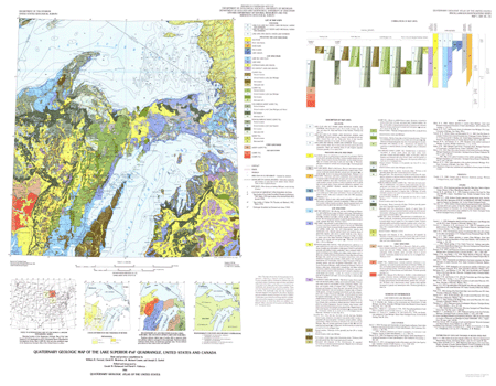
GEOCODE--Refers to the type of polygon and is one of the following: the map unit abbreviation, "lake", "island", or "river".
AGE--Refers to the age of the map unit and is one of the following: "Holocene", "Holocene and Late Wisconsin", "Late Wisconsin", "Early Wisconsin", or "Pre Wisconsin".
MORAINES--A modifier to the map unit indicating if the unit is a moraine and is one of the following: "Ground moraine", "Ground moraine under Lake Michigan", "Ground moraine under Lakes Michigan and Huron", "Ground moraine under Lake Superior", "End moraine", or "Attenuated drift".
MAP_UNITS--A description of the soils within the map units (see below).
MODIFIER--Indicates the names of rivers, lakes, or islands or indicates if a map unit is submerged.
COLOR--indicates the number of the shade unit in shadeset color524.shd used to fill the map units when plotted using the AML script superior.aml.
Items in geo_net.pat are defined as follows:
GEOCODE        MAP_UNITS, (AGE)
lm       LAKE CLAY AND SILT UNDER LAKES MICHIGAN, HURON, AND
           SUPERIOR (HOLOCENE)
lc       LAKE SILT AND CLAY UNDER LAKES MICHIGAN, HURON, AND
           SUPERIOR (HOLOCENE)
ls       LAKE SAND AND GRAVEL UNDER LAKE SUPERIOR (HOLOCENE)
al       ALLUVIUM (HOLOCENE AND LATE WISCONSIN)
hp       PEAT AND MUCK (HOLOCENE AND LATE WISCONSIN)
ed       DUNE SAND (HOLOCENE AND LATE WISCONSIN)
lds      DELTA SAND (HOLOCENE AND LATE WISCONSIN)
lga      LAKE GRAVEL (HOLOCENE AND LATE WISCONSIN)
lca      LAKE SILT AND CLAY (LATE WISCONSIN)
lsa      LAKE SAND (LATE WISCONSIN)
gg       OUTWASH SAND AND GRAVEL (LATE WISCONSIN)
kg       ICE-CONTACT SAND AND GRAVEL (LATE WISCONSIN)
tc       CLAYEY TILL, Ground moraine (LATE WISCONSIN)
tc       CLAYEY TILL, Ground moraine under Lake Michigan
           (LATE WISCONSIN)
tc       CLAYEY TILL, End moraine (LATE WISCONSIN)
tcr      CLAYEY TILL, Attenuated drift (LATE WISCONSIN)
tl       LOAMY TILL, Ground moraine (LATE WISCONSIN)
tl       LOAMY TILL, Ground moraine under Lake Michigan
           (LATE WISCONSIN)
tl       LOAMY TILL, End moraine (LATE WISCONSIN)
tlr      LOAMY TILL, Attenuated drift (LATE WISCONSIN)
td       CALCAREOUS SANDY LOAMY TILL, Ground moraine
           (LATE WISCONSIN)
td       CALCAREOUS SANDY LOAMY TILL, Ground moraine under
           Lakes Michigan and Huron (LATE WISCONSIN)
td       CALCAREOUS SANDY LOAMY TILL, End moraine (LATE WISCONSIN)
tdr      CALCAREOUS SANDY LOAMY TILL, Attenuated drift
           (LATE WISCONSIN)
tdb      NONCALCAREOUS SANDY LOAMY TILL, Ground moraine (LATE
           WISCONSIN)
tdb      NONCALCAREOUS SANDY LOAMY TILL, Ground moraine under Lake
           Superior (LATE WISCONSIN)
tdb      NONCALCAREOUS SANDY LOAMY TILL, End moraine (LATE WISCONSIN)
tdr      NONCALCAREOUS SANDY LOAMY TILL, Attenuated drift (LATE
           WISCONSIN)
ts       SANDY TILL, Ground moraine (LATE WISCONSIN)
tsr      SANDY TILL, Attenuated drift (LATE WISCONSIN)
tde      SANDY LOAMY TILL (EARLY WISCONSIN)
tlp      LOAMY TILL (PRE WISCONSIN)
tlq      LOAMY TILL (PRE WISCONSIN)
The geo_net.aat INFO file consists of the following items: LTYPE--Refers to the type of arc and is one of the following: "contact", "shoreline", "map boundary", or "null". Null is the imaginary line separating streams from lakes. ACCURACY--Refers to accuracy of location of arcs in the geo_net coverage and is either "certain" or "inferred".
The gla_lin coverage contains lines that represent linear glacial features. The gla_lin.aat INFO file consists of the following items: TYPE--Refers to the type of glacial feature described by the arc and is one of the following: "esker", "map boundary", or "limit of glacial advance". MODIFIER--Refers only to limits of glacial advance that are "interlobate". ACCURACY--Refers to accuracy of location of arcs in the gla_lin coverage and is either "certain" or "inferred".
The gla_pnt coverage contains points that represent drumlins, places where the direction of ice movement is indicated by striations, or the location of important stratigraphic sections. The gla_pnt.pat INFO file consists of the following items: TYPE--Refers to the type of feature shown at the point and is one of the following: "drumlin", "direction of ice movement", or the name of important stratigraphic sections. ANGLE--Refers to the direction of drumlin or ice movement; in degrees measured clockwise from north. MRKANGLE--Negative of ANGLE; useful for plotting symbols in ARCPLOT.
Hydr_lin is a line coverage created after scanning the hydrographic layer that was used in the original paper map. It has no user-defined attributes.
Topo_lin is a line coverage created after scanning the topographic layer that was used in the original paper map. It has no user-defined attributes.
Bnd_lin is a line coverage created from 1:2,000,000-scale U.S. Geological Survey Digital Line Graph coverages (DLG). It contains lines representing the U.S./Canada international boundary and state boundaries. The bnd_lin.aat INFO file contains the following item: TYPE--Refers to the type of line and contains the values: "state boundary", "international boundary", or "map boundary".
Bnd_net is a polygon coverage created from 1:2,000,000-scale DLG coverages and contains political and administrative boundaries. To decrease the size of the coverage, all user-defined attributes have been removed except "STATE_NAME" and "AREA_NAME".
Rd_lin is a line coverage created from 1:2,000,000-scale DLG coverages. The coverage contains lines representing roads in the map area. All DLG attributes have been stripped from the lines except ENTITY_LABEL, ROUTE_NUMBER1, ROUTE_NUMBER2, and ROUTE_NUMBER3 which contain the federal and state highway number designations.
Rr_lin is a line coverage created from 1:2,000,000-scale DLG coverages. The coverage contains lines representing railroads in the map area. It has no DLG attributes.
Grid_lin is a line coverage created to display projection lines in one degree increments. It has no attributes.
Entity_and_Attribute_Detail_Citation: none

Distribution_Information:
Distributor:
Contact_Information:
Contact_Organization_Primary:
Contact_Organization:
U.S. Geological Survey, Geologic Division, Central Publications Group
Contact_Address:
Address_Type: Mailing address
Address:
U.S. Geological Survey, MS902, Box 25046, Denver Federal
Center
City: Denver
State_or_Province: CO
Postal_Code: 80225
Country: USA
Contact_Voice_Telephone: (303) 236-7684
Contact_Facsimile_Telephone: (303) 236-6287
Contact_Electronic_Mail_Address: gellis@usgs.gov

Resource_Description: USGS Miscellaneous Investigations Series Map I-1420 (NL-16)
Distribution_Liability:
Any use of trade, product, or firm names is for descriptive purposes only and does not imply endorsement by the U.S. Government. Although this data set has been used by the U.S. Geological Survey, no warranty, expressed or implied, is made by the USGS as to the accuracy and functioning of the data set and related material nor shall the fact of distribution constitute any such warranty, and no responsibility is assumed by the USGS in connection therewith.
Standard_Order_Process:
Digital_Form:
Digital_Transfer_Information:
Format_Name: ARCE, Shapefile
Format_Version_Number: 7.2.1
Format_Information_Content:
Geologic units, structural features, diagrams, and ancillary data
File_Decompression_Technique: DOS/Windows Zip
Digital_Transfer_Option:
Online_Option:
Computer_Contact_Information:
Network_Address:
Fees: none
Metadata_Reference_Information:
Metadata_Date: 20160613
Metadata_Contact:
Contact_Information:
Contact_Person_Primary:
Contact_Person: Peter N Schweitzer
Contact_Organization: USGS Midwest Area
Contact_Position:
Collection manager, USGS Geoscience Data Clearinghouse, http://geo-nsdi.er.usgs.gov/
Contact_Address:
Address_Type: mailing address
Address:
Mail Stop 954
12201 Sunrise Valley Dr
City: Reston
State_or_Province: VA
Postal_Code: 20192-0002
Country: USA
Contact_Voice_Telephone: 703-648-6533
Contact_Facsimile_Telephone: 703-648-6252
Contact_Electronic_Mail_Address: pschweitzer@usgs.gov
Metadata_Standard_Name: Content Standard for Digital Geospatial Metadata
Metadata_Standard_Version: FGDC-STD-001-1998


This page is <https://geo-nsdi.er.usgs.gov/metadata/map-i/1420/NL-16/metadata.html>
Generated by mp version 2.9.48 on Tue Jul 03 20:04:46 2018