The geo_net coverage includes polygons that are map units and
open water, and arcs that are contacts, color boundaries, and
shoreline.
The geo_net.pat INFO file consists of the following items:
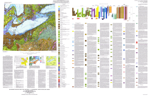
GEOCODE--Refers to the type of polygon and is one of the following:
map unit code (e.g., tl,tsa), "lake", or "river".
AGE--Refers to the age of the map unit and is one of the following:
"EARLY WISCONSIN AND ILLINOIAN", "EARLY WISCONSIN", "HOLOCENE
AND LATE WISCONSIN", "HOLOCENE AND WISCONSIN", "HOLOCENE",
"ILLINOIAN AND PRE-ILLINOIAN", "ILLINOIAN", "LATE WISCONSIN AND
MIDDLE WISC", "LATE WISCONSIN", "WISCONSIN", OR "PRE-QUATERNARY".
MORAINES--A modifier to the map unit indicating that the unit is a
moraine and is one of the following: "Ground Moraine", "Ground
moraine and end moraine", "Ground Moraine and end moraine under
Lake Erie", "Ground Moraine and end moraine under Lake Ontario",
"Ground Moraine and end moraine under Lakes Erie and Ontario",
"End Moraine", or "Attenuated drift", "Ground Moraine under
Lake Erie", "Ground Moraine under Lake Huron", "Ground Moraine
under Lakes Erie and Ontario", "Ground moraine veneer over nonoriented
hummocky topography of older till or ice-contact sand and gravel", or
"Stagnation moraine".
MAPUNITS--A description of the soils within the map units (see below).
MODIFIER--Indicates the names of labeled rivers and lakes or
indicates if the map unit is submerged or is a veneer.
COLOR--An integer value representing a shade pattern in the shadeset
color524.shd used in preparing the graphic of the map.
Items in geo_net.pat are defined as follows:
GEOCODE	MAPUNITS, (AGE)

lm	LAKE CLAY AND SILT (under Lakes Huron, Erie, and Ontario),
	   (HOLOCENE)
ls	LAKE SAND AND GRAVEL (under Lakes Huron, Erie, and Ontario),
	   (HOLOCENE)
al	ALLUVIUM (HOLOCENE AND LATE WISCONSIN)
lc	LAKE SILT AND CLAY (under Lakes Huron, Erie, and Ontario),
        (HOLOCENE AND LATE WISCONSIN)
lcb	LAKE CLAY, SILT, SAND, AND GRAVEL (under Lakes St. Clair
	   and Erie), (HOLOCENE AND LATE WISCONSIN)
lcc	LAKE CLAY, SILT, SAND, AND GRAVEL (HOLOCENE AND
        LATE WISCONSIN)
lca	LAKE SILT AND CLAY (HOLOCENE AND LATE WISCONSIN)
lsa	LAKE SAND AND GRAVEL (HOLOCENE AND LATE WISCONSIN)
hs	SWAMP DEPOSIT (HOLOCENE AND LATE WISCONSIN)
hp	PEAT (HOLOCENE AND LATE WISCONSIN)
ed	DUNE SAND (HOLOCENE AND LATE WISCONSIN)
eu	EOLIAN SAND AND SILT (HOLOCENE AND LATE WISCONSIN)
cbb	BOULDERY COLLUVIUM AND ROCK WASTE (HOLOCENE AND WISCONSIN)
cl	LOAMY COLLUVIUM (HOLOCENE AND WISCONSIN)
clc	LOAMY COLLUVIUM (HOLOCENE AND WISCONSIN)
cld	LOAMY COLLUVIUM  (HOLOCENE AND WISCONSIN)
jla	LOAMY COLLUVIUM AND LANDSLIDE DEPOSITS--Areas with abundant
	   or widely distributed landslide deposits (HOLOCENE AND
	   WISCONSIN)
jlb	LOAMY COLLUVIUM AND LANDSLIDE DEPOSITS--Areas with scattered
	   or localized landslide deposits (HOLOCENE AND WISCONSIN)
Tills in Michigan, Ohio, Pennsylvania, and New York
tc	CLAYEY TILL, Ground moraine, (LATE WISCONSIN)
tc	CLAYEY TILL, End moraine (LATE WISCONSIN)
tcd	CLAYEY TILL, Ground moraine under Lake Erie, (LATE WISCONSIN)
tcd	CLAYEY TILL, End moraine, (LATE WISCONSIN)
tca	CLAYEY TILL, Ground moraine, (LATE WISCONSIN)
tca	CLAYEY TILL, Ground moraine under Lake Erie, (LATE WISCONSIN)
tca	CLAYEY TILL, Ground moraine veneer (LATE WISCONSIN)
tca	CLAYEY TILL, End moraine (LATE WISCONSIN)
tcb	CLAYEY TILL, Ground moraine (LATE WISCONSIN)
tcb	CLAYEY TILL, Stagnation moraine, (LATE WISCONSIN)
tcb	CLAYEY TILL, End moraine (LATE WISCONSIN)
tcg	CLAYEY TILL, Ground moraine (LATE WISCONSIN)
tcg	CLAYEY TILL, Ground moraine veneer (LATE WISCONSIN)
tl	LOAMY TILL, Ground moraine (LATE WISCONSIN)
tl	LOAMY TILL, Ground moraine under Lake Huron, (LATE WISCONSIN)
tl	LOAMY TILL, Ground moraine veneer (LATE WISCONSIN)
tl	LOAMY TILL, Stagnation moraine, (LATE WISCONSIN)
tl	LOAMY TILL, End moraine (LATE WISCONSIN)
tlb	LOAMY TILL, Ground moraine, (LATE WISCONSIN)
tlb	LOAMY TILL, Ground moraine veneer (LATE WISCONSIN)
tlb	LOAMY TILL, End moraine (LATE WISCONSIN)
tld	LOAMY TILL, Ground moraine, (LATE WISCONSIN)
tld	LOAMY TILL, End moraine (LATE WISCONSIN)
tlg	LOAMY TILL, Ground moraine (LATE WISCONSIN)
tlg	LOAMY TILL, Ground moraine under Lakes Erie and Ontario
	   (LATE WISCONSIN)
tlg	LOAMY TILL, Ground moraine veneer (LATE WISCONSIN)
tlg	LOAMY TILL, Stagnation moraine (LATE WISCONSIN)
tlg	LOAMY TILL, End moraine (LATE WISCONSIN)
tlr	LOAMY TILL, Attenuated drift (LATE WISCONSIN)
tlh	LOAMY TILL, Ground moraine (LATE WISCONSIN)
tlh	LOAMY TILL, End moraine (LATE WISCONSIN)
td	SANDY LOAMY TILL, Ground moraine (LATE WISCONSIN)
td	SANDY LOAMY TILL, End moraine (LATE WISCONSIN)
Tills in Ontario (Ground moraine and end moraine not distinguished)
tap	CLAYEY TILL (LATE WISCONSIN)
taa	CLAYEY TILL (LATE WISCONSIN)
tab	CLAYEY TILL, Ground moraine and end moraine (LATE WISCONSIN)
tab	CLAYEY TILL, Ground moraine and end moraine under Lakes
	   Erie and Ontario (LATE WISCONSIN)
tak	CLAYEY TILL, Ground moraine and end moraine (LATE WISCONSIN)
tak	CLAYEY TILL, Ground moraine under Lake Huron
        (LATE WISCONSIN)
taq	CLAYEY TILL (LATE WISCONSIN)
tae	CLAYEY TILL, Ground moraine and end moraine, (LATE WISCONSIN)
tae	CLAYEY TILL, Ground moraine and end moraine under Lake Erie
	   (LATE WISCONSIN)
tai	CLAYEY TILL (LATE WISCONSIN)
tao	CLAYEY TILL (LATE WISCONSIN)
taf	CLAYEY TILL (LATE WISCONSIN)
tka	LOAMY TILL, Ground moraine and end moraine (LATE WISCONSIN)
tka	LOAMY TILL, Ground moraine and end moraine under Lake Ontario
(LATE WISCONSIN)
tkk	LOAMY TILL, Ground moraine and end moraine (LATE WISCONSIN)
tkk	LOAMY TILL, Ground moraine and end moraine under Lake Erie
	   (LATE WISCONSIN)
tkl	LOAMY TILL (LATE WISCONSIN)
tkg	LOAMY TILL (LATE WISCONSIN)
tkn	LOAMY TILL (LATE WISCONSIN)
tkh	LOAMY TILL (LATE WISCONSIN)
tko	LOAMY TILL (LATE WISCONSIN)
tkf	LOAMY TILL (LATE WISCONSIN)
tki	LOAMY TILL (LATE WISCONSIN)
teb	SANDY LOAMY TILL (LATE WISCONSIN)
kg	ICE-CONTACT SAND AND GRAVEL (LATE WISCONSIN)
ks	ICE-CONTACT SAND (LATE WISCONSIN)
ke	KAME END MORAINE (LATE WISCONSIN)
gg	OUTWASH SAND AND GRAVEL (LATE WISCONSIN)
gs	OUTWASH SAND (LATE WISCONSIN)
gkl	OUTWASH SAND AND GRAVEL (LATE WISCONSIN)
lcr	ATTENUATED LAKE SILT AND CLAY (LATE WISCONSIN)
lla	SLACKWATER LAKE SILT AND SAND (LATE WISCONSIN)
nlc	LOAMY SOLIFLUCTION DEPOSITS (LATE WISCONSIN)
lch	LAKE SAND, SILT, AND CLAY (LATE WISCONSIN AND MIDDLE WISCONSIN)
lcj	LAKE SAND, SILT, AND CLAY (WISCONSIN)
lgk	LAKE GRAVEL, SAND, SILT, AND CLAY (WISCONSIN)
tar	CLAYEY TILL (EARLY WISCONSIN)
tlj	LOAMY TILL (EARLY WISCONSIN)
tle	LOAMY TILL (EARLY WISCONSIN)
tdg	SANDY LOAMY TILL (EARLY WISCONSIN)
kgb	ICE-CONTACT SAND AND GRAVEL (EARLY WISCONSIN)
nma	CLAYEY TO SANDY SOLIFLUCTION DEPOSITS (WISCONSIN AND
	   ILLINOIAN)
nla	LOAMY SOLIFLUCTION DEPOSITS (WISCONSIN AND ILLINOIAN)
nlb	LOAMY SOLIFLUCTION DEPOSITS (WISCONSIN AND ILLINOIAN)
gga	OUTWASH SAND AND GRAVEL (EARLY WISCONSIN AND ILLINOIAN)
llb	SLACKWATER LAKE SILT AND SAND (EARLY WISCONSIN AND
        ILLINOIAN)
tcm	CLAYEY TILL, Ground moraine (ILLINOIAN)
tcm	CLAYEY TILL, End moraine (ILLINOIAN)
tlm	LOAMY TILL (ILLINOIAN)
tlo	LOAMY TILL (ILLINOIAN)
kgi	ICE-CONTACT SAND AND GRAVEL (ILLINOIAN)
ggi	OUTWASH SAND AND GRAVEL (ILLINOIAN)
lci	LAKE CLAY AND SILT (ILLINOIAN)
lle	LAKE SAND, SILT, AND CLAY (ILLINOIAN AND PRE-ILLINOIAN)
rci	LOAMY TO CLAYEY SOLUTION RESIDUUM (QUATERNARY)
zla	LOAMY DECOMPOSITION RESIDUUM (QUATERNARY)
zlb	LOAMY DECOMPOSITION RESIDUUM (QUATERNARY)
R	BEDROCK, (PRE-QUATERNARY)
f	MANMADE LAND
The geo_net.aat INFO file consists of the following item:
LTYPE--Refers to the type of arc and is one of the following:
"contact", "shoreline", "map boundary", or "null".
The gla_lin coverage contains lines of linear glacial features.
The gla_lin.aat INFO file consists of the following items:
TYPE--Refers to the type of glacial feature described by the arc
and is one of the following: "esker", "limit of glacial
advance", "buried moraine", "crest of end moraine", "meltwater
channel", or "map boundary".
MODIFIER--Refers only to type = "meltwater channel" and IS
either "left bank" or "right bank".
ACCURACY--Refers to accuracy of location of arcs in the gla_lin
coverage and is either "certain" or "inferred".
CONTACT--Refers to whether the line is a contact between map units and
is either "y" or "n".
The gla_pnt coverage contains points that represent drumlins,
places where the direction of ice movement is indicated by
striations, or the location of important stratigraphic sections.
The gla_pnt.pat INFO file consists of the following items:
TYPE--Refers to the type of feature shown at the point and is
one of the following: "drumlin", "direction of ice movement",
"ice molded landform", "sand dune", or the name of important
stratigraphic sections.
ANGLE--Refers to the direction of drumlin or ice movement; in
degrees measured clockwise from north.
MRKANGLE--Negative of ANGLE; useful for plotting srmbols in ARCPLOT.
Hydr_lin is a line coverage created after scanning the hydrographic
layer that was used in the original paper map. It has no attributes.
Topo_lin is a line coverage created after scanning the topographic
layer that was used in the original paper map. It has no attributes.
Bnd_lin is a line coverage created from 1:2,000,000 scale U.S.
Geological Survey Digital Line Graph coverages (DLG). It contains
lines representing the U.S./Canada international boundary and state
boundaries and annotation indicating state or province names.
The bnd_lin.aat INFO file contains the following item:
TYPE--Refers to the type of line and contains the values: "state
boundary", "international boundary", or "map boundary".
Bnd_net is a polygon coverage created from 1:2,000,000 scale DLG
coverages and contains political and administrative boundaries.
Polygons are attributed in the standard DLG coding scheme and the
Federal Information Processing Standards (FIPS).
Rd_lin is a line coverage created from 1:2,000,000 DLG coverages.
The coverage contains lines representing roads in the map area.
All DLG attributes have been stripped from the lines except
ROUTE_NUMBER1, ROUTE_NUMBER2, and ROUTE_NUMBER3, which contain the
federal and state highway number designations, and ROUTE_TYPE1, which
may contain values of "Alternate", "Business", or "Truck".
Rr_lin is a line coverage created from 1:2,000,000 DLG coverages.
The coverage contains lines representing railroads in the map area.
It has no DLG attributes.
Grid_lin is a line coverage created to display projection lines in
one degree increments. It has no attributes.