Online Links:
Online Links:
| Range of values | |
|---|---|
| Minimum: | 1 |
| Maximum: | 2811 |
| Value | Definition |
|---|---|
| "SED_CHEM, SEDGRAIN" | |
| (empty) |
| Value | Definition |
|---|---|
| (empty) |
| Range of values | |
|---|---|
| Minimum: | 29.2 |
| Maximum: | 30.37343245 |
| Units: | decimal degrees |
| Value | Definition |
|---|---|
| (empty) |
| Range of values | |
|---|---|
| Minimum: | 29 |
| Maximum: | 30 |
| Units: | degrees of arc |
| Resolution: | 1 |
| Value | Definition |
|---|---|
| (empty) |
| Range of values | |
|---|---|
| Minimum: | 0 |
| Maximum: | 59 |
| Units: | minutes of arc |
| Resolution: | 1 |
| Value | Definition |
|---|---|
| (empty) |
| Range of values | |
|---|---|
| Minimum: | 0 |
| Maximum: | 59 |
| Units: | arc-seconds |
| Resolution: | 1 |
| Value | Definition |
|---|---|
| ddmm.mm | degrees and decimal minutes, to 0.01 minutes |
| ddmm.mmm | degrees and decimal minutes, to 0.001 minutes |
| ddmmss | degrees, minutes, and seconds |
| (empty) | Location specified in the original report as decimal degrees |
| Value | Definition |
|---|---|
| (empty) |
| Range of values | |
|---|---|
| Minimum: | -88.67 |
| Maximum: | -92.76417 |
| Units: | decimal degrees |
| Resolution: | 0.000001 |
| Value | Definition |
|---|---|
| -90 | probably supposed to be 90 degrees W |
| (empty) |
| Range of values | |
|---|---|
| Minimum: | 88 |
| Maximum: | 92 |
| Units: | degrees of arc |
| Resolution: | 1 |
| Value | Definition |
|---|---|
| (empty) |
| Range of values | |
|---|---|
| Minimum: | 0 |
| Maximum: | 59 |
| Units: | minutes of arc |
| Resolution: | 1 |
| Value | Definition |
|---|---|
| (empty) |
| Range of values | |
|---|---|
| Minimum: | 0 |
| Maximum: | 59 |
| Units: | arc-seconds |
| Resolution: | 1 |
| Value | Definition |
|---|---|
| ddmm.mm | degrees and decimal minutes, to 0.01 minutes |
| ddmm.mmm | degrees and decimal minutes, to 0.001 minutes |
| ddmmss | degrees, minutes, and seconds |
| (empty) | Location specified in the original report as decimal degrees |
| Value | Definition |
|---|---|
| "the LORAN C coordinates in fields 8 & 13 were e-mailed to AGM by G.Flowers on 4-28-97. the coordinates in fields 7 & 12 were calculated by AGM from a faxed copy of figure 1 of Sarkar's thesis (see file""SSCONVERT.DOC"" for full details)" | |
| (empty) | not known |
| Value | Definition |
|---|---|
| (empty) |
| Range of values | |
|---|---|
| Minimum: | 0 |
| Maximum: | 14 |
| Units: | meters |
| Resolution: | 1 |
| Value | Definition |
|---|---|
| (empty) |
| Range of values | |
|---|---|
| Minimum: | 0 |
| Maximum: | 26 |
| Value | Definition |
|---|---|
| feet | |
| ft | feet |
| (empty) |
| Value | Definition |
|---|---|
| LDEQ | Louisiana Department of Environmental Quality |
| LDEQ-OWR-WPCD | Louisiana Department of Environmental Quality - Office of Water Resources - Water Pollution Control Division |
| LDNR-CZMD | Louisiana Department of Natural Resources - Coastal Zone Management Division |
| LSU | Louisiana State University |
| UNO | University of New Orleans |
| USEPA | United States Environmental Protection Agency |
| USACE | United States Army Corps of Engineers |
| USGS | United States Geological Survey |
| USGS - WRD | United States Geological Survey - Water Resources Division |
| Value | Definition |
|---|---|
| "EMAP-Estuaries Province Level Database, Louisianian Province 1991-1994" | |
| (empty) |
| Value | Definition |
|---|---|
| EMAP | Environmental Monitoring and Assessment Program |
| Value | Definition |
|---|---|
| Louisiana | |
| (empty) | information not provided |
| Value | Definition |
|---|---|
| BLaBr | Bayou LaBranche |
| BretS | Breton Sound |
| BTrep | Bayou Trepagnier |
| CMent | Chef Menteur |
| EngCa | Engineers Canal |
| ICW | Intracoastal Waterway |
| IHNC | Inner Harbor Navigation Canal |
| LBorg | Lake Borgne |
| LMaur | Lake Maurepas |
| LP | Lake Pontchartrain |
| LP-BC | Lake Pontchartrain, Bonnet Carre Region |
| LP-CE | Lake Pontchartrain, central region east of Causeway |
| LP-CW | Lake Pontchartrain, central region west of Causeway |
| LP-NO | Lake Pontchartrain, New Orleans region |
| LP-NS | Lake Pontchartrain, north shore region |
| LP-PH | Lake Pontchartrain, Pointe aux Herbes region |
| LP-RG | Lake Pontchartrain, Rigolets region |
| LP-WS | Lake Pontchartrain, west shore region |
| MissB | Mississippi Bayou |
| MRGO | Mississippi River Gulf Outlet |
| Rigol | Rigolets |
| Value | Definition |
|---|---|
| (empty) |
| Range of values | |
|---|---|
| Minimum: | 1 |
| Maximum: | 88 |
| Value | Definition |
|---|---|
| (empty) |
| Range of values | |
|---|---|
| Minimum: | 1 |
| Maximum: | 31 |
| Units: | day |
| Resolution: | 1 |
| Value | Definition |
|---|---|
| 1 | January |
| 2 | February |
| 3 | March |
| 4 | April |
| 5 | May |
| 6 | June |
| 7 | July |
| 8 | August |
| 9 | September |
| 10 | October |
| 11 | November |
| 12 | December |
| (empty) | date not specified |
| Value | Definition |
|---|---|
| (empty) |
| Range of values | |
|---|---|
| Minimum: | 1972 |
| Maximum: | 1998 |
| Units: | year |
| Resolution: | 1 |
| Value | Definition |
|---|---|
| 23 | 23rd day of the month? |
| (empty) |
| Value | Definition |
|---|---|
| 6 | June |
| 10 | October |
| (empty) | date not specified |
| Value | Definition |
|---|---|
| (empty) |
| Range of values | |
|---|---|
| Minimum: | 1980 |
| Maximum: | 1984 |
| Units: | year |
| Resolution: | 1 |
| Value | Definition |
|---|---|
| No date stated for sediment analysis | |
| (empty) |
| Value | Definition |
|---|---|
| (empty) |
| Range of values | |
|---|---|
| Minimum: | 11 |
| Maximum: | 13 |
| Units: | hour of day |
| Resolution: | 1 |
| Value | Definition |
|---|---|
| (empty) | time not available |
| Range of values | |
|---|---|
| Minimum: | 0 |
| Maximum: | 55 |
| Units: | minutes |
| Resolution: | 1 |
| Value | Definition |
|---|---|
| 6/1/80 | June 1, 1980 |
| 10/23/84 | October 23, 1984 |
| (empty) |
| Value | Definition |
|---|---|
| """a coring device""" | |
| "0.1 m^2 box corer, subsampled using a 4.25 inch polycarbonate core liner" | |
| Box corer | |
| Eckman mechanical grab sampler | |
| Peterson dredge | |
| Petite ponar | |
| Petite Ponar dredge | |
| Petite ponar dredge | |
| Petite ponar grab | |
| piston corer | |
| scoop sampler | |
| spade corer | |
| unknown | |
| unknown corer | |
| Van Veen Grab | |
| Vibracore | |
| (empty) |
| Value | Definition |
|---|---|
| none | not available |
| sediment | sediment sample |
| Value | Definition |
|---|---|
| (empty) |
| Range of values | |
|---|---|
| Minimum: | 0 |
| Maximum: | 144 |
| Units: | centimeters |
| Resolution: | 1 |
| Value | Definition |
|---|---|
| (empty) |
| Range of values | |
|---|---|
| Minimum: | 7 |
| Maximum: | 505 |
| Units: | centimeters |
| Resolution: | 1 |
| Value | Definition |
|---|---|
| inches | |
| (empty) |
| Value | Definition |
|---|---|
| Core | |
| Surface | |
| Surface of core | |
| (empty) |
| Value | Definition |
|---|---|
| """Three samples were taken at each location and homogenized by mixing using plastic utensils.""" | |
| sample is a homogenate composed of the surficial 2 cm from several grabs (see methods field in grain size table for additional comments) | |
| (empty) | sample not combined with others |
| Value | Definition |
|---|---|
| BASE | Stations that were randomly selected based on EMAP sampling design (grid). |
| INDEX | Stations that were paired with small estuary and tidal river base sites. They were intended to represent the area of sediment deposition with the estuary or river. Not random. |
| ITE | Indicator Testing and Evaluation Sites - only for 1991. Selected specifically to test indicators' ability to discriminate between degraded and reference sites. |
| SUPPL | Stations that were randomly selected by using the EMAP grid design and reducing it to fit within a single estuary. |
| QA/QC | The replicate sampling of a base station (exact location) within a short time span. (Collection methods quality reference.) |
| REP-91 | Between-year replicates of 1991 base sites. These 1991 sites were sampled every year to represent variation and long term trends. (No within-year replicates, see next definition.) |
| REP-9? | Randomly selected sites that are "near-by" to one another to evaluate variability within a given area (for example, within a hexagon or small estuary). Used to test the EMAP design. |
| VARIANCE | Trend sites selected to evaluate variation and long term trends (selected in addition to the REP-91 sites). |
| Value | Definition |
|---|---|
| """at least 200cc" | |
| (empty) |
| Value | Definition |
|---|---|
| n | no |
| no; see Byrne | qualified no |
| y | yes |
| (empty) |
| Value | Definition |
|---|---|
| n | no |
| no: see McFall et al | qualified no |
| y | yes |
| (empty) |
| Value | Definition |
|---|---|
| n | no |
| y | yes |
| (empty) |
| Value | Definition |
|---|---|
| n | bioassay data not collected |
| y | bioassay data were collected |
| (empty) |
| Value | Definition |
|---|---|
| n | no other analyses were found |
| y | additional analyses were found |
| (empty) | we do not know whether other analyses are documented in the reference |
| Value | Definition |
|---|---|
| "6 water microbiology parameters, 5 sediment microbiological parameters, benthic invertebrate analysis, 60 species of fish collected" | |
| "Toxicity Test Data, Water Quality Vertical Profile, Benthic Data, Fish/Invertebrate Data" | |
| benthic fauna counts | |
| (empty) |
| Value | Definition |
|---|---|
| (empty) |
| Range of values | |
|---|---|
| Minimum: | 4 |
| Maximum: | 31 |
| Units: | day of the month |
| Resolution: | 1 |
| Value | Definition |
|---|---|
| 1 | January |
| 2 | February |
| 4 | April |
| 5 | May |
| 8 | August |
| 9 | September |
| 10 | October |
| 11 | November |
| 12 | December |
| Range of values | |
|---|---|
| Minimum: | 1996 |
| Maximum: | 2000 |
| Units: | year |
| Resolution: | 1 |
| Value | Definition |
|---|---|
| agm | Andrew G. McIntire |
| LH | Laura Hayes |
| Value | Definition |
|---|---|
| <DL | Less than detection limit. (Concentration reads "0" because the measurement fell below the detection limit). |
| DV | Discriminant value (For discussion of discriminant functions see Analytical Methods and Quality Control). |
| DVS | 25% of samples for this component and source show unresolved anomalies in discriminant values. |
| HA | High Alert (see table 8 for alert levels). |
| LA | Low Alert (see table 8 for alert levels). |
| Leach | Leachate method was used for metal analysis. Values resulting from this type of analysis have valid uses but are not comparable to those resulting from total dissolution methods. See Discussion and Inorganic Chemistry sections for more explanation. |
| LW | Source reports data on a wet-weight basis, which gives lower apparent values than dry-weight basis. mean (n = *) Multiple samples were collected from the same location and analyzed; the value reported is the mean (n = number of replicates). |
| ND | Not detected. |
| Repl. DL | A replicate value is below detection limit (the value reported is the mean of the others). |
| W | Warning: unresolved questions (no quality-control corroboration or causal relationships for anomalous data are available). |
| Range of values | |
|---|---|
| Minimum: | 231 |
| Maximum: | 2625 |
| Value | Definition |
|---|---|
| 2 types of samples analyzed: A subsample of the composited homogenate (top 2-3 cm of sediment taken from collective grabs) was analyzed for grain distribution. Also small core samples taken from each of 3 grabs were used for determination of % silt/clay. | |
| A subsample of the composited homogenate (top 2-3 cm of sediment taken from collective grabs) was used to determine % silt/clay. (Grain size distribution not analyzed. No small cores collected). | |
| small core samples taken from each of 3 grabs were used for determination of % silt/clay. (Grain size distribution dropped as parameter). | |
| (empty) |
| Value | Definition |
|---|---|
| SAND_PCT = 100 - FINES_SIL. The percent sand calculation is: %sand = sand wt/(sand wt + silt-clay wt) * 100 | |
| SAND_PCT was interpreted (estimated) by F. Manheim from lithologic descriptions written by P. Connor | |
| (empty) |
| Value | Definition |
|---|---|
| (empty) |
| Range of values | |
|---|---|
| Minimum: | 0 |
| Maximum: | 99.5 |
| Units: | percent dry weight of sample |
| Resolution: | 0.1 |
| Value | Definition |
|---|---|
| (empty) |
| Range of values | |
|---|---|
| Minimum: | 0 |
| Maximum: | 87 |
| Units: | percent dry weight of sample |
| Resolution: | 0.1 |
| Value | Definition |
|---|---|
| (empty) |
| Range of values | |
|---|---|
| Minimum: | 0.64 |
| Maximum: | 89.67 |
| Units: | percent dry weight of sample |
| Resolution: | 0.1 |
| Value | Definition |
|---|---|
| (empty) |
| Range of values | |
|---|---|
| Minimum: | 0.5 |
| Maximum: | 99.6 |
| Units: | percent dry weight of sample |
| Resolution: | 0.1 |
| Value | Definition |
|---|---|
| W | data appear to have unresolved anomalies |
| (empty) | no anomalies indicated |
| Value | Definition |
|---|---|
| (empty) |
| Range of values | |
|---|---|
| Minimum: | 0.5 |
| Maximum: | 10.27 |
| Units: | phi |
| Resolution: | 0.01 |
| Value | Definition |
|---|---|
| (empty) |
| Range of values | |
|---|---|
| Minimum: | 2.26 |
| Maximum: | 9.64 |
| Units: | phi |
| Resolution: | 0.01 |
| Value | Definition |
|---|---|
| (empty) |
| Range of values | |
|---|---|
| Minimum: | 0.2 |
| Maximum: | 3.9 |
| Units: | phi |
| Resolution: | 0.1 |
| Value | Definition |
|---|---|
| (empty) |
| Range of values | |
|---|---|
| Minimum: | 1.8 |
| Maximum: | 7.9 |
| Units: | phi |
| Resolution: | 0.1 |
| Value | Definition |
|---|---|
| (empty) |
| Range of values | |
|---|---|
| Minimum: | 0.5 |
| Maximum: | 2 |
| Units: | phi |
| Resolution: | 0.1 |
| Value | Definition |
|---|---|
| (empty) |
| Range of values | |
|---|---|
| Minimum: | 0.72 |
| Maximum: | 8.75 |
| Units: | phi |
| Resolution: | 0.1 |
| Value | Definition |
|---|---|
| (empty) |
| Range of values | |
|---|---|
| Minimum: | -0.1 |
| Maximum: | 0.77 |
| Units: | phi |
| Resolution: | 0.1 |
| Value | Definition |
|---|---|
| (empty) |
| Range of values | |
|---|---|
| Minimum: | 0.6 |
| Maximum: | 9.73 |
| Units: | phi |
| Resolution: | 0.1 |
| Value | Definition |
|---|---|
| phi units (-1)-0 | |
| (empty) |
| Value | Definition |
|---|---|
| 0 | none |
| (empty) |
| Value | Definition |
|---|---|
| phi units 0-1 | |
| (empty) |
| Value | Definition |
|---|---|
| (empty) |
| Range of values | |
|---|---|
| Minimum: | 0 |
| Maximum: | 14 |
| Units: | percent by weight |
| Resolution: | 1 |
| Value | Definition |
|---|---|
| phi units 1-2 | |
| (empty) |
| Value | Definition |
|---|---|
| (empty) |
| Range of values | |
|---|---|
| Minimum: | 0 |
| Maximum: | 34 |
| Units: | percent by weight |
| Resolution: | 1 |
| Value | Definition |
|---|---|
| phi units 2-3 | |
| (empty) |
| Value | Definition |
|---|---|
| (empty) |
| Range of values | |
|---|---|
| Minimum: | 0 |
| Maximum: | 26 |
| Units: | percent by weight |
| Resolution: | 1 |
| Value | Definition |
|---|---|
| phi units 3-4 | |
| (empty) |
| Value | Definition |
|---|---|
| (empty) |
| Range of values | |
|---|---|
| Minimum: | 0 |
| Maximum: | 30 |
| Units: | percent by weight |
| Resolution: | 1 |
| Value | Definition |
|---|---|
| phi units 4-5 | |
| (empty) |
| Value | Definition |
|---|---|
| (empty) |
| Range of values | |
|---|---|
| Minimum: | 0 |
| Maximum: | 48 |
| Units: | percent by weight |
| Resolution: | 1 |
| Value | Definition |
|---|---|
| phi units 5-6 | |
| (empty) |
| Value | Definition |
|---|---|
| (empty) |
| Range of values | |
|---|---|
| Minimum: | 1 |
| Maximum: | 14 |
| Units: | percent by weight |
| Resolution: | 1 |
| Value | Definition |
|---|---|
| phi units 6-7 | |
| (empty) |
| Value | Definition |
|---|---|
| (empty) |
| Range of values | |
|---|---|
| Minimum: | 0 |
| Maximum: | 18 |
| Units: | percent by weight |
| Resolution: | 1 |
| Value | Definition |
|---|---|
| phi units 7-8 | |
| (empty) |
| Value | Definition |
|---|---|
| (empty) |
| Range of values | |
|---|---|
| Minimum: | 0 |
| Maximum: | 21 |
| Units: | percent by weight |
| Resolution: | 1 |
| Value | Definition |
|---|---|
| phi units 8-9 | |
| (empty) |
| Value | Definition |
|---|---|
| (empty) |
| Range of values | |
|---|---|
| Minimum: | 0 |
| Maximum: | 19 |
| Units: | percent by weight |
| Resolution: | 1 |
| Value | Definition |
|---|---|
| phi units 9-10 | |
| (empty) |
| Value | Definition |
|---|---|
| (empty) |
| Range of values | |
|---|---|
| Minimum: | 0 |
| Maximum: | 16 |
| Units: | percent by weight |
| Resolution: | 1 |
| Value | Definition |
|---|---|
| phi units >10 | |
| (empty) |
| Value | Definition |
|---|---|
| (empty) |
| Range of values | |
|---|---|
| Minimum: | 5 |
| Maximum: | 48 |
| Units: | percent by weight |
| Resolution: | 1 |
| Value | Definition |
|---|---|
| see METHOD_CO | (evidently not first initial and last name) |
| (empty) |
| Value | Definition |
|---|---|
| "sand, silt, and clay = ***" | |
| "sand, silt, and clay all the same (41.52)" | |
| "upper 3 inches of core samples analyzed using: Folk, Robert L., 1968. Petrology of sedimentary rocks. University of Tex. 182 p." | |
| Data derived from fig.21 of referenced source. Figure consists of line graphs for each station showing % by weight of 12 classes of phi units. Figure was gridded and values were estimated for each class at each station. | |
| missing data due to loss of samples | |
| Texture too coarse? | |
| (empty) |
| Value | Definition |
|---|---|
| estimated sand% from Dunbar's data | |
| Values for this reference do not always total 100%. Average total for all sites is 103%; range is 90-116%. Classes: sand (-1)-0 to 4-5; silt: 4-5 to 8-9; clay: 8-9 to >10. | |
| (empty) |
Special acknowledgment is given here to S.J. Williams (Chief Scientist of the USGS Coastal and Marine Geology Program, Reston, VA) who provided the initial opportunity for this database development and supplied extensive documents that permitted initiation of data entry. J.L. Kindinger (USGS Coastal and Marine Geology Program, St. Petersburg, FL) provided cooperation throughout the work. A.G. McIntire (now U.S. Bureau of Census, Geography - TIGER Mapping Branch, Upper Marlboro, MD) entered many of the early data sets, converted the database to an initial Microsoft® Access format, and created many of the illustrations in the preliminary publication (Manheim, Hayes, and McIntire, 1998). G.C. Flowers (Tulane University Department of Geology, New Orleans, LA) provided an important unpublished electronic data set. We are grateful for the cooperation of J. Macauley and L. Harwell (US EPA, EMAP Program, Gulf Breeze, FL) for providing unpublished data and clarifying many details about the EMAP data for southern Louisiana estuaries. Finally, we are indebted to the many organizations and participants listed in Participants and Cooperators for the data and cooperation.
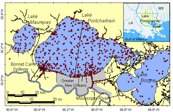
The data are preliminary results of a project to develop a comprehensive database of chemical and environmental information on sediments from Lake Pontchartrain, LA, and surrounding water bodies. The goal is to evaluate all data for reliability and comparability, make them widely accessible to all users, and interpret the data with respect to the environmental status of these important estuaries. It is part of a larger 5-year research program investigating the geological framework of Lake Pontchartrain, LA (FY 1994-FY 1999), begun by S.J. Williams and currently under overall leadership of J.L. Kindinger (USGS, St. Petersburg, FL).
Are there legal restrictions on access or use of the data?Access_Constraints: none
Use_Constraints: none
Sediment chemical and other data on this CD-ROM and the companion web site have been compiled from multiple sources. Reasonable care has been taken in transcription, and efforts have been made to provide quality control of the data as described in the relevant sections. Although efforts have been made to screen for and identify data that may be seriously compromised, the data provided here are not guaranteed to be correct or complete. Responsibility for the data remains with the original sources and not the U.S. Geological Survey (except where USGS analyses are involved), and conclusions drawn from the data are the responsibility of the users. Mention of commercial software or services does not imply endorsement by the USGS.
| Data format: | Station location and sample characteristics, grain-size, and geochemical measurements in format Columnar text (tab-delimited) Tab characters delimit fields; newline characters (LF) delimit records Size: 2.1 |
|---|---|
| Network links: |
http://pubs.usgs.gov/pp/p1634j/sed_data/db_txt/station.txt http://pubs.usgs.gov/pp/p1634j/sed_data/db_txt/grain_sz.txt http://pubs.usgs.gov/pp/p1634j/sed_data/db_txt/inorgan.txt http://pubs.usgs.gov/pp/p1634j/sed_data/db_txt/gen_org.txt http://pubs.usgs.gov/pp/p1634j/sed_data/db_txt/organa.txt http://pubs.usgs.gov/pp/p1634j/sed_data/db_txt/organb.txt http://pubs.usgs.gov/pp/p1634j/sed_data/db_txt/organc.txt http://pubs.usgs.gov/pp/p1634j/sed_data/db_txt/organd.txt http://pubs.usgs.gov/pp/p1634j/sed_data/db_txt/organu.txt http://pubs.usgs.gov/pp/p1634j/sed_data/db_txt/cas_no.txt |
| Data format: | Station location and sample characteristics, grain-size, and geochemical measurements in format Microsoft Access (MDB) (version 97) Size: 0.5 |
|---|---|
| Network links: |
http://pubs.usgs.gov/pp/p1634j/sed_data/pont_dbmdb.zip |
| Data format: | Station location and sample characteristics, grain-size, and geochemical measurements in format XLS (version 97) Size: 0.7 |
|---|---|
| Network links: |
http://pubs.usgs.gov/pp/p1634j/sed_data/pont_db.zip |