fskn_geo.e00              Contacts, faults, geologic unit labels
fskn_str.e00              Fold axes
fskn_pts.e00              Attitudes and their dip values
fsknps_pts.e00            Attitudes and their dip values
fsknorn_pts.e00           Fold axes ornamentation
fskn_ldr.e00              Leaders for polygon labels and fault names
lines.rel.e00             Line dictionary
points.rel.e00            Point dictionary
fawnskin_summary.e00      SCAMP-coded summary info
fawnskin_lithology.e00    SCAMP-coded lithology
fawnskin_structure.e00    SCAMP-coded structural features
fawnskin_genesis.e00      SCAMP-coded unit genesis
fawnskin_paleontology.e00 SCAMP-coded paleontology
fawnskin_protolith.e00    SCAMP-coded protolith info
Online Links:
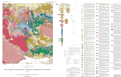
| Value | Definition |
|---|---|
| Qaf | Artificial Fill (late Holocene) |
| Qw | Active-wash deposits (late Holocene) |
| Qf | Deposits of alluvial fans (late Holocene) |
| Qa | Deposits of axial valley floors (late Holocene) |
| Qc | Colluvial deposits (late Holocene) |
| Qt | Talus deposits (late Holocene) |
| Qls | Landslide deposits (late Holocene) |
| Qs | Undifferentiated alluvial deposits (late Holocene) |
| Qyf | Young deposits of alluvial fans (Holocene and late Pleistocene) |
| Qyf5 | Young deposits of alluvial fans, unit 5 (late Holocene) |
| Qyf4 | Young deposits of alluvial fans, unit 4 (late Holocene) |
| Qyf3 | Young deposits of alluvial fans, unit 3 (late and middle Holocene) |
| Qyf2 | Young deposits of alluvial fans, unit 2 (early Holocene) |
| Qyf1 | Young deposits of alluvial fans, unit 1 (early Holocene and late Pleistocene) |
| Qya | Young deposits of axial valley floors (Holocene and late Pleistocene) |
| Qyc | Young colluvial deposits (Holocene and late Pleistocene) |
| Qyt | Young talus deposits (Holocene and late Pleistocene) |
| Qyls | Young landslide deposits (Holocene and late Pleistocene) |
| Qys | Young surficial deposits undifferentiated (Holocene and late Pleistocene) |
| Qof | Old deposits of alluvial fans (late to middle Pleistocene) |
| Qof3 | Old deposits of alluvial fans, unit 3 (late Pleistocene) |
| Qof2 | Old deposits of alluvial fans, unit 2 (late Pleistocene) |
| Qoa | Old deposits of allvial-valley floors, undifferentiated (late to middle Pleistocene) |
| Qot | Old talus deposits (late to middle Pleistocene) |
| Qols | Old landslide deposits (late to middle Pleistocene) |
| Qos | Old surficial deposits undifferentiated (late to middle Pleistocene) |
| Qvof | Very old deposits of alluvial fans (middle to early Pleistocene) |
| Qvof3 | Very old deposits of alluvial fans, unit 3 (early Pleistocene) |
| Qvof2 | Very old deposits of alluvial fans, unit 2 (early Pleistocene) |
| Qvols | Very old landslide deposits (middle to early Pleistocene) |
| Qvos | Very old surficial deposits, undifferentiated (late to middle Pleistocene) |
| Qvobc | Very old deposits of catastrophic carbonate breccia (early Pleistocene) |
| Qvobg | Very old deposits of catastrophic granitic breccia (early Pleistocene) |
| QTcp | Conglomerate, porphyry-bearing facies (Pleistocene? and Pliocene?) |
| QTcc | Conglomerate, Cushenberry facies (Pleistocene? and Pliocene?) |
| QTsc | Sandstone and conglomerate (Pleistocene? and Pliocene?) |
| QTscp | Sandstone and conglomerate, porphyry facies (Pleistocene? and Pliocene?) |
| QTscc | Sandstone and conglomerate, Cushenberry facies (Pleistocene? and Pliocene?) |
| QTom | Old Woman Sandstone, mudrock and sandstone member (Pleistocene? and Pliocene?) |
| QTos | Old Woman Sandstone, sandstone memeber (Pleistocene? and Pliocene?) |
| Ts4 | Sedimentary rocks south of Big Bear Lake (Miocene?) |
| Ts3 | Sedimentary rocks south of Bertha Ridge and John Bull Mountain (Miocene?) |
| Ts2 | Sedimentary rocks of Poligue Canyon (Miocene?) |
| Ts1 | Sedimentary rocks of Holocomb Valley (Miocene?) |
| Ts | Sandstone (Miocene?) |
| Mzu | Undivided granitic rocks of range front (Cretaceous to Jurassic) |
| Kbm | Biotite monzogranite (Cretaceous) |
| Kb | Monzogranite of John Bull Flat (Cretaceous) |
| Ks | Monzogranite of Stanfield Cutoff (Cretaceous) |
| Kbp | Monzogranite of Butler Peak (Cretaceous) |
| Kk | Monzogranite of Keller Peak (Cretaceous) |
| Kh | Granodiorite of Hanna Flat (Cretaceous) |
| Kgc | Monzogranite of Greenlead Creek (Creteacous) |
| KJb | Granodiorite of Bousic Canyon (Cretaceous or Jurassic) |
| KJdg | Mafic mafic diorite and gabbro (Cretaceous or Jurassic) |
| KJl | Leucocratic granitic rocks (Cretaceous to Jurassic) |
| Jh | Volcanic and hypabyssal rocks of Holcomb Valley area (Jurassic?) |
| Jcr | Cataclastic rocks (Jurassic) |
| Jb | Bertha Peak Pluton of Cameron (1981) (Jurassic) |
| Jfc | Quartz monzonite porphyry of Furnace Canyon Jurassic) |
| Jc | Leucocratic quartz monzonite of Crystal Creek (Jurassic) |
| Jd | Quartz monzodiorite of Dry Canyon (Jurassic) |
| Jdm | Deformed monzogranite of hill 4970 (Jurassic) |
| Jsc | Fine-grained rocks of Silver Canyon (Jurassic) |
| Trf | Monzonite of Fawnskin (Triassic) |
| Pbuc | Bird Spring Formation, upper carbonate member (Pennsylvanian) |
| Pbmc | Bird Spring Formation, middle carbonate member (Pennsylvanian) |
| Pblc | Bird Spring Formation, lower carbonate member (Pennsylvanian) |
| Pbsc | Bird Spring Formation, siltstone and carbonate Member (Pennsylvanian) |
| Pbq | Bird Spring Formation, quartzite member (Pennsylvanian) |
| Mmy | Monte Cristo Limestone, Yellowpine Member (Mississippian) |
| Mmb | Monte Cristo Limestone, Bullion Member (Mississippian) |
| Mml | Monte Cristo Limestone, lower member (Mississippian) |
| Dsc | Sultan Limestone, Crystal Pass Member (Devonian) |
| Dsv | Sultan Limestone, Valentine Member (Devonian) |
| Dsi | Sultan Limestone, Ironside Member (Devonian) |
| Cn | Nopah Formation (Cambrian) |
| Cnd | Dunderburg Shale Member (Cambrian) |
| Cb | Bonanza King Formation, undivided (Cambrian) |
| Cba | Bonanza King Formation, argillaceous marker unit (Cambrian) |
| Cbdg | Bonanza King Formation, gray dolomite member (Cambrian) |
| Cbdw | Bonanza King Formation, white dolomite member (Cambrian) |
| Cbm | Bonanza King Formation, middle member (Cambrian) |
| Cbl | Bonanza King Formation, lower member (Cambrian) |
| Cc | Carrara Formation (Cambrian) |
| Cz | Zabriskie Quartzite (Cambrain) |
| Cw | Wood Canyon Formation (Cambrian) |
| Prsq | Stirling Quartzite, quartzite member (late Proterozoic) |
| Prscq | Stirling Quartzite, carbonate and quartzite member (late Proterozoic) |
| Value | Definition |
|---|---|
| C1 | Contact, generic, location meets map accuracy standards |
| C18 | Contact, landslide, location may not meet map accuracy standards |
| C19 | Contact, landslide, inferred, location may not meet map accuracy standards |
| C25 | Contact, landslide crown scarp, location meets map accuracy standards |
| C26 | Contact, landslide crown scarp, location may not meet map accuracy standards |
| C29 | Contact, sedimentary, location may meet map accuracy standards |
| C30 | Contact, sedimentary, location may not meet map accuracy standards |
| C32 | Contact, sedimentary, inferred beneath mapped covering unit |
| C37 | Contact, separates terraced alluvial units, location meets map accuracy standards |
| C38 | Contact, separates terraced alluvial units, location may not meet map accuracy standards |
| C49 | Contact, igneous, location meets map accuracy standards |
| C50 | Contact, igneous, location may not meet map accuracy standards |
| C51 | Contact, igneous, inferred, location meets map accuracy standards |
| CL1 | Cartographic line, map boundary |
| F1 | Fault, high-angle, slip unspecified, location meets map accuracy standards |
| F10 | Fault, high-angle, normal slip, location may not meet map accuracy standards |
| F162 | Fault, low-angle, thrust slip, older over younger, location meets map accuracy standards |
| F177 | Fault, low-angle, thrust slip, older over younger, location meets map accuracy standards |
| F178 | Fault, low-angle, thrust slip, older over younger, location may not meet map accuracy standards |
| F180 | Fault, low-angle, thrust slip, older over younger, inferred beneath mapped covering unit |
| F19 | Fault, high-angle, slip unspecified, inferred beneath mapped covering unit |
| F193 | Fault, low-angle, thrust slip, older over younger, has fault scarp, location meets map accuracy standards |
| F2 | Fault, high-angle, right-lateral strike-slip, location meets map accuracy standards |
| F20 | Fault, high-angle, right-lateral strike-slip, inferred beneath mapped covering unit |
| F205 | Fault, variable angle dip, rotational normal slip, location meets map accuracy standards |
| F206 | Fault, variable angle dip, rotational normal slip, location may not meet map accuracy standards |
| F208 | Fault, variable angle dip, rotational normal slip, inferred beneath mapped covering unit |
| F22 | Fault, high-angle, normal slip, inferred beneath mapped covering unit |
| F220 | Fault, intruded, preintrusive existence inferred |
| F4 | Fault, high-angle, normal slip, location meets map accuracy standards |
| F5 | Fault, high-angle, reverse slip, location meets map accuracy standards |
| F53 | Fault, high-angle, reverse slip, has fault scarp, location meets map accuracy standards |
| F7 | Fault, high-angle, slip unspecified, location may not meet map accuracy standards |
| FZ1 | Fault zone boundary, scratch contact |
| FZ3 | Cataclastic zone boundary, scratch contact |
| GF10 | Geomorphic feature, lakeshore |
| GF7 | Geomorphic feature, topographic scarp, origin unknown |
| Value | Definition |
|---|---|
| B2 | Bedding attitude, sedimentary, inclined |
| B4 | Bedding attitude, sedimentary, vertical |
| B6 | Bedding attitude, sedimentary, overturned |
| FN13 | Foliation attitude, igneous flow origin, inclined |
| FN31 | Foliation attitude, strain dominated origin, inclined |
| FN42 | Foliation attitude, metamorphic origin, inclined |
| FN43 | Foliation attitude, metamorphic origin, vertical |
| L16 | Lineation attitude, crushed and streaked mineral grains |
| Value | Definition |
|---|---|
| FA33 | Fold axial trace, anticline, upright, subhorizontal plunge, location meets map accuracy standards |
| FA36 | Fold axial trace, anticline, upright, subhorizontal plunge, inferred beneath mapped covering unit |
| FA49 | Fold axial trace, anticline, overturned, subhorizontal plunge, location meets map accuracy standards |
| FA97 | Fold axial trace, syncline, upright, subhorizontal plunge, location meets map accuracy standards |
| FA100 | Fold axial trace, syncline, upright, subhorizontal plunge, inferred beneath mapped covering unit |
| FA113 | Fold axial trace, syncline, overturned, subhorizontal plunge, location meets map accuracy standards |
| Value | Definition |
|---|---|
| FAC10 | Fold ornament, syncline, upright axial plane |
| FAC12 | Fold ornament, anticline, overturned axial plane |
| FAC4 | Fold ornament, anticline, upright axial plane |
| FAC6 | Fold ornament, anticline, overturned axial plane |
Technical review by Douglas M. Morton led to significant improvements that eventually were reflected in aspects of the database, the plot file, and in the description of the geologic units of the Fawnskin 7.5' quadrangle. Digital review by R.W. Grymer allowed us to produce a much improved product.
Geologic mapping and digital preparation of this report were sponsored jointly by (1) the National Cooperative Geologic Mapping Program of the U.S. Geological Survey, (2) the California Division of Mines and Geology, and (3) the Southern California Areal Mapping Project (SCAMP). In our digital preparation of the data set, initiated in the SCAMP Geographic Information System laboratory in Riverside, California by Gregory Morton and completed in the Geographic Information System laboratory of the Mineral Resources Program of the U.S. Geological Survey in Spokane, Washington by Pamela M. Cossette, we received valuable assistance from Paul C. Hyndman in Spokane, Washington, and from Rachel Alvarez in Riverside.
The data set for the Fawnskin quadrangle has been prepared by the Southern California Areal Mapping Project (SCAMP), a cooperative project sponsored jointly by the U.S. Geological Survey and the California Division of Mines and Geology, as part of an ongoing effort to utilize a Geographical Information System (GIS) format to create a regional digital geologic database for southern California. This regional database is being developed as a contribution to the National Geologic Map Data Base of the National Cooperative Geologic Mapping Program ofthe USGS. Development of the data set for the Fawnskin quadrangle has also been supported by the U.S. Forest Service, San Bernardino National Forest.
The digital geologic map database for the Fawnskin quadrangle has been created as a general-purpose data set that is applicable to other land-related investigations in the earth and biological sciences. For example, the U.S. Forest Service, San Bernardino National Forest, is using the database as part of a study of an endangered plant species, California Buckwheat, that shows preference for particular rock types. The Fawnskin database is not suitable for site-specific geologic evaluations at scales greater than 1:24,000 (1 in = 2,000 ft).
Online Links:
Are there legal restrictions on access or use of the data?Access_Constraints: None
Use_Constraints:The Fawnskin 7.5' geologic-map database should be used to evaluate and understand the geologic character of the Fawnskin 7.5' quadrangle as a whole. The data should not be used for purposes of site-specific land-use planning or site-specific geologic evaluations. The database is sufficiently detailed to identify and characterize geologic materials and structures. However, it is not sufficiently detailed for site-specific determinations.
Use of this digital geologic map database should not violate the spatial resolution of the data. Although the digital form of the data removes the constraint imposed by the scale of a paper map, the detail and accuracy inherent in map scale are also present in the digital data. The fact that this database was compiled and edited at a scale of 1:24,000 means that higher resolution information may not have been uniformly retained in the dataset. Plotting at scales larger than 1:24,000 will not yield greater real detail, although it may reveal fine-scale irregularities below the intended resolution of the database. Similarly, although higher resolution data is incorporated in most of the map, the resolution of the combined output will be limited by the lower resolution data.
The U.S. Geological Survey (USGS) provides these geographic data "as is." The USGS makes no guarantee or warranty concerning the accuracy of information contained in the geographic data. The USGS further makes no warranties, either expressed or implied as to any other matter whatsoever, including, without limitation, the condition of the product, or its fitness for any particular purpose. The burden for determining fitness for use lies entirely with the user. Although these data have been processed successfully on computers at the USGS, no warranty, expressed or implied, is made by the USGS regarding the use of these data on any other system, nor does the fact of distribution constitute or imply any such warranty.
In no event shall the USGS have any liability whatsoever for payment of any consequential, incidental, indirect, special, or tort damages of any kind, including, but not limited to, any loss of profits arising out of use of or reliance on the geographic data or arising out of delivery, installation, operation, or support by USGS.
This digital, geologic map database of the Fawnskin 7.5'quadrangle, 1:24,000 map-scale, and any derivative maps thereof, is not meant to be used or displayed at any scale larger than 1:24,000 (e.g., 1:12,000).
| Data format: | Geologic units, structural features, point measurements in format ARCE (version 7.1.1) Size: 3.5 |
|---|---|
| Network links: |
http://pubs.usgs.gov/of/1998/0579/fskn.tar.gz |