ARC/INFO coverages
sm_um-py.e00
  Faults, depositional contacts, and rock units in San Mateo County
sm_um-sr.e00
  Strike and dip information and fold axes in San Mateo County
sm_quad.e00
  Index map of quadrangles in San Mateo County.
sm_um-flt.e00
  Index map of faults in San Mateo County with annotation showing the names of major faults.
sm_corr.e00
  Correlation table for the units in this map database.
sm_so.e00
  Sources of data index map for this map database.
sm_as.e00
  Index map of Assemblages in San Mateo County.  (Assemblages are described in smgeo.txt or smgeo.ps)
sm_um-dr.e00
  Drainage base map (from 1:100,000 scale original).
sm_um-cu.e00
  Cultural base map (from 1:100,000 scale original).
sm_um-topo.e00
  Topographic contours base map (from 1:100,000 scale original).
Online Links:
| Value | Definition |
|---|---|
| contact, certain | Boundary between two mapped units that was observed. |
| contact, concealed | Boundary between two mapped units that is concealed and its position inferred. |
| contact, approx. located | Boundary between two mapped units whose position is not precisely known. |
| fault, certain | Strike-slip fault that was observed. |
| fault, concealed | Strike-slip fault that is concealed and its position inferred. |
| fault, concealed, queried | Strike-slip fault that is concealed and ... queried? |
| fault, approx. located | Strike-slip fault whose position is not precisely known. |
| fault, inferred | Strike-slip fault whose position is inferred. |
| reverse fault, certain | Reverse fault that was observed. |
| reverse fault, concealed | Reverse fault that is concealed and its position inferred. |
| scratch boundary | Boundary used for printing a diagram. |
| water boundary | Boundary of a body of water. |
| map boundary | Boundary of the mapped area. |
| Value | Definition |
|---|---|
| 0 | |
| 3 | |
| 4 | |
| 5 | |
| 6 |
| Value | Definition |
|---|---|
| contact, certain | Boundary between two mapped units that was observed. |
| scratch boundary | Boundary used for printing a diagram |
| Value | Definition |
|---|---|
| contact, certain | Boundary between two mapped units that was observed. |
| Value | Definition |
|---|---|
| leader | Line drawn to associate a number with one of the smaller mapped areas, when it would be impractical to place the identifying number inside the area. |
| map boundary, | Boundary of the mapped area. |
| Value | Definition |
|---|---|
| fault, certain | Strike-slip fault that was observed. |
| fault, concealed | Strike-slip fault that is concealed and its position inferred. |
| fault, concealed, queried | Strike-slip fault that is concealed and ... queried? |
| fault, approx. located | Strike-slip fault whose position is not precisely known. |
| fault, inferred | Strike-slip fault whose position is inferred. |
| reverse fault, certain | Reverse fault that was observed. |
| reverse fault, concealed | Reverse fault that is concealed and its position inferred. |
| Value | Definition |
|---|---|
| 0 | |
| 1 | |
| 3 | |
| 4 | |
| 5 |
| Value | Definition |
|---|---|
| contact, certain | Boundary between two mapped units that was observed. |
| contact, concealed | Boundary between two mapped units that is concealed and its position inferred. |
| contact, approx. located | Boundary between two mapped units whose position is not precisely known. |
| fault, certain | Strike-slip fault that was observed. |
| fault, concealed | Strike-slip fault that is concealed and its position inferred. |
| fault, concealed, queried | Strike-slip fault that is concealed and ... queried? |
| fault, inferred | Strike-slip fault whose position was inferred. |
| fault, inferred, queried | Strike-slip fault whose position was inferred and ... queried? |
| fault, approx. located | Strike-slip fault whose position is not precisely known. |
| fault, inferred | Strike-slip fault whose position is inferred. |
| reverse fault, certain | Reverse fault that was observed. |
| reverse fault, concealed | Reverse fault that is concealed and its position inferred. |
| reverse fault, approx. located | Reverse fault whose position is not known with precision. |
| scratch boundary | Boundary used for printing a diagram. |
| water boundary | Boundary of a body of water. |
| water boundary, | Boundary of a body of water. The comma at the end of the value is present in the database. |
| map boundary | Boundary of the mapped area. |
| map boundary, | Boundary of the mapped area. The comma at the end of the value is present in the database. |
| Value | Definition |
|---|---|
| 0 | |
| 1 | |
| 3 | |
| 4 | |
| 5 | |
| 6 |
| Value | Definition |
|---|---|
| f.a., anticline, certain | Fold axis of an anticline that was observed. |
| f.a., anticline, concealed | Fold axis of an anticline that is concealed and its position inferred. |
| f.a., syncline, certain | Fold axis of a syncline that was observed. |
| f.a., syncline, concealed | Fold axis of a syncline that is concealed and its position inferred. |
| Value | Definition |
|---|---|
| (blank) | Map boundary polygon |
| H2O | water body |
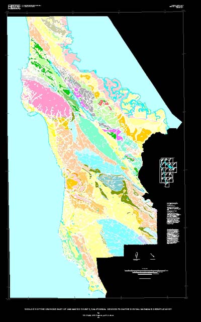
| af | Artificial fill (Historic) |
| alf | Artificial levee fill (Historic) |
| Qhasc | Artificial stream channels (Historic) |
| Qhsc | Stream channel deposits (Holocene) |
| Qhbd | Beach deposits (Holocene) |
| Qhbm | Bay mud (Holocene) |
| Qhb | Basin deposits (Holocene) |
| Qhfp | Floodplain deposits (Holocene) |
| Qhl | Natural levee deposits (Holocene) |
| Qhaf | Alluvial fan and fluvial deposits (Holocene) |
| Qyf | Younger (inner) alluvial fan deposits (Holocene) |
| Qyfo | Younger (outer) alluvial fan deposits (Holocene) |
| Qcl | Colluvium (Holocene) |
| Qs | Sand dune and beach deposits (Holocene) |
| Qal | Alluvium (Holocene) |
| Qpaf | Alluvial fan and fluvial deposits (Pleistocene) |
| Qpaf1 | Alluvial terrace deposits (Pleistocene) |
| Qpoaf | Older alluvial fan deposits (Pleistocene) |
| Qof | Coarse-grained older alluvial fan and stream terrace deposits (Pleistocene) |
| Qmt | Marine terrace deposits (Pleistocene) |
| Qc | Colma Formation (Pleistocene) |
| QTsc | Santa Clara Formation (lower Pleistocene and upper Pliocene) |
| QTm | Merced Formation (lower Pleistocene and upper Pliocene) |
| Tp | Purisima Formation (Pliocene and upper Miocene) |
| Tptu | Tunitas Sandstone Member (Pliocene) |
| Tpl | Lobitos Mudstone Member (Pliocene) |
| Tpsg | San Gregorio Sandstone Member (Pliocene) |
| Tpp | Pomponio Mudstone Member (Pliocene) |
| Tpt | Tahana Member (Pliocene and upper Miocene) |
| Tsc | Santa Cruz Mudstone (upper Miocene) |
| Tsm | Santa Margarita Sandstone (upper Miocene) |
| Tl | Ladera Sandstone (upper(?) and middle Miocene) |
| Tm | Monterey Formation (middle Miocene) |
| Tlo | Lompico Sandstone (middle Miocene) |
| Tpm | Page Mill Basalt (middle Miocene) |
| Tuv | Unnamed Sedimentary and Volcanic Rocks (Miocene and Oligocene) |
| Tls | Lambert Shale and San Lorenzo Formation, Undivided (lower Miocene, Oligocene, and middle and upper Eocene) |
| Tla | Lambert Shale (Oligocene and lower Miocene) |
| Tmb | Mindego Basalt and related volcanic rocks (Miocene and/or Oligocene) |
| Tvq | Vaqueros Sandstone (lower Miocene and Oligocene) |
| Tsl | San Lorenzo Formation (Oligocene and upper and middle Eocene) |
| Tsr | Rices Mudstone Member (Oligocene and upper Eocene) |
| Tst | Twobar Shale Member (middle and upper Eocene) |
| Tb | Butano Sandstone (middle and lower Eocene) |
| Tbs | Shale in Butano Sandstone (lower Eocene) |
| Tw | Whiskey Hill Formation (middle and lower Eocene) |
| Tws | Shale in Whiskey Hill Formation (lower Eocene) |
| Tss | Unnamed sandstone, shale, and conglomerate (Paleocene) |
| Kpp | Pigeon Point Formation (Upper Cretaceous) |
| Ksh | Unnamed shale (Upper Cretaceous) |
| Ka | Anchor Bay Conglomerate (Cretaceous) |
| Ks | Unnamed sandstone and shale (Cretaceous?) |
| Kgr | Granitic rocks of Montara Mountain |
| KJv | Unnamed volcanic rocks (Cretaceous or older) |
| KJs | Unnamed sandstone (Cretaceous or Jurassic) |
| KJf | Franciscan Complex, undivided (Cretaceous and Jurassic) |
| fs | Sandstone |
| fg | Greenstone |
| fc | Chert |
| fl | Limestone |
| fm | Metamorphic rocks |
| fcg | Conglomerate |
| fsr | Sheared rock (melange) |
| sp | Serpentinite (Cretaceous and/or Jurassic) |
| Jsv | Siliceous volcanic rocks and keratophyre (Jurassic?) |
| Jgb | Gabbro (Jurassic?) |
| m | Marble and hornfels (Paleozoic?) |
| Value | Definition |
|---|---|
| (blank) | Map boundary polygon |
| H2O | water body |
| af | Artificial fill (Historic) |
| alf | Artificial levee fill (Historic) |
| Qhasc | Artificial stream channels (Historic) |
| Qhsc | Stream channel deposits (Holocene) |
| Qhbd | Beach deposits (Holocene) |
| Qhbm | Bay mud (Holocene) |
| Qhb | Basin deposits (Holocene) |
| Qhfp | Floodplain deposits (Holocene) |
| Qhl | Natural levee deposits (Holocene) |
| Qhaf | Alluvial fan and fluvial deposits (Holocene) |
| Qyf | Younger (inner) alluvial fan deposits (Holocene) |
| Qyfo | Younger (outer) alluvial fan deposits (Holocene) |
| Qcl | Colluvium (Holocene) |
| Qs | Sand dune and beach deposits (Holocene) |
| Qal | Alluvium (Holocene) |
| Qpaf | Alluvial fan and fluvial deposits (Pleistocene) |
| Qpaf1 | Alluvial terrace deposits (Pleistocene) |
| Qpoaf | Older alluvial fan deposits (Pleistocene) |
| Qof | Coarse-grained older alluvial fan and stream terrace deposits (Pleistocene) |
| Qmt | Marine terrace deposits (Pleistocene) |
| Qc | Colma Formation (Pleistocene) |
| QTsc | Santa Clara Formation (lower Pleistocene and upper Pliocene) |
| QTm | Merced Formation (lower Pleistocene and upper Pliocene) |
| Tp | Purisima Formation (Pliocene and upper Miocene) |
| Tptu | Tunitas Sandstone Member (Pliocene) |
| Tpl | Lobitos Mudstone Member (Pliocene) |
| Tpsg | San Gregorio Sandstone Member (Pliocene) |
| Tpp | Pomponio Mudstone Member (Pliocene) |
| Tpt | Tahana Member (Pliocene and upper Miocene) |
| Tsc | Santa Cruz Mudstone (upper Miocene) |
| Tsm | Santa Margarita Sandstone (upper Miocene) |
| Tl | Ladera Sandstone (upper(?) and middle Miocene) |
| Tm | Monterey Formation (middle Miocene) |
| Tlo | Lompico Sandstone (middle Miocene) |
| Tpm | Page Mill Basalt (middle Miocene) |
| Tuv | Unnamed Sedimentary and Volcanic Rocks (Miocene and Oligocene) |
| Tls | Lambert Shale and San Lorenzo Formation, Undivided (lower Miocene, Oligocene, and middle and upper Eocene) |
| Tla | Lambert Shale (Oligocene and lower Miocene) |
| Tmb | Mindego Basalt and related volcanic rocks (Miocene and/or Oligocene) |
| Tvq | Vaqueros Sandstone (lower Miocene and Oligocene) |
| Tsl | San Lorenzo Formation (Oligocene and upper and middle Eocene) |
| Tsr | Rices Mudstone Member (Oligocene and upper Eocene) |
| Tst | Twobar Shale Member (middle and upper Eocene) |
| Tb | Butano Sandstone (middle and lower Eocene) |
| Tbs | Shale in Butano Sandstone (lower Eocene) |
| Tw | Whiskey Hill Formation (middle and lower Eocene) |
| Tws | Shale in Whiskey Hill Formation (lower Eocene) |
| Tss | Unnamed sandstone, shale, and conglomerate (Paleocene) |
| Kpp | Pigeon Point Formation (Upper Cretaceous) |
| Ksh | Unnamed shale (Upper Cretaceous) |
| Ka | Anchor Bay Conglomerate (Cretaceous) |
| Ks | Unnamed sandstone and shale (Cretaceous?) |
| Kgr | Granitic rocks of Montara Mountain |
| KJv | Unnamed volcanic rocks (Cretaceous or older) |
| KJs | Unnamed sandstone (Cretaceous or Jurassic) |
| KJf | Franciscan Complex, undivided (Cretaceous and Jurassic) |
| fs | Sandstone |
| fg | Greenstone |
| fc | Chert |
| fl | Limestone |
| fm | Metamorphic rocks |
| fcg | Conglomerate |
| fsr | Sheared rock (melange) |
| sp | Serpentinite (Cretaceous and/or Jurassic) |
| Jsv | Siliceous volcanic rocks and keratophyre (Jurassic?) |
| Jgb | Gabbro (Jurassic?) |
| m | Marble and hornfels (Paleozoic?) |
| Value | Definition |
|---|---|
| bedding | A depositional surface |
| flat bedding | A flat depositional surface |
| foliation | A surface of metamorphic origin |
| joint | Planar fractures |
| ot bedding | Overturned bedding (older rocks on top) |
| vert bedding | Vertical bedding surface |
| vert foliation and bedding | Vertical foliation parallel to bedding |
| vert joint | Vertical planar fractures |
| Range of values | |
|---|---|
| Minimum: | 0 |
| Maximum: | 90 |
| Units: | degrees |
| Resolution: | 1 |
| Range of values | |
|---|---|
| Minimum: | 0 |
| Maximum: | 359 |
| Units: | degrees |
| Resolution: | 1 |
SEL   user defined field used to save a selected set
SYMB  user defined field used to save symbol assignments (such as color)
The geologic linetypes are ALACARTE line types that correlate with the geologic line symbols in the ALACARTE line set GEOL61.LIN according to the ALACARTE lines lookup table (GEOL61.LUT).
We are grateful to the following U.S. Geological Survey paleontologists who have examined our fossils and provided ages necessary to establish the stratigraphic sequence and structure: David Bukry (Cretaceous and Tertiary nannoplankton), Kristin McDougall (Tertiary foraminifers), Willam Sliter (deceased - Cretaceous and Eocene foraminifers), John Barron (Tertiary diatoms), Charles Powell II (Tertiary mollusks), and Bonita Murchey (Mesozoic radiolaria).
We are also very grateful to managers and staff of Chevron, EXXON, UNOCAL, ARCO, and Shell Petroleum Companies who have provided reports, maps, picked slides, and residues for about 25,000 microfossil localities in the San Francisco Bay Region.
We are grateful to Tracey Felger, who made the original scan and a preliminary edit of author materials; to Judy Mariant, who did additional editing and tagging of lines; and to Dominique Garnier, who digitized many of the bedding attitudes. Carl Wentworth kindly provided advice on digitizing and editing procedures. Ed Helley provided materials and advice on Quaternary units.
This map is intended to be of general use to engineers and land-use planners. However, its small scale does not provide sufficient detail for site development purposes. In addition, this map does not take the place of fault-rupture hazard zones designated by the California State Geologist (Hart, 1988). Similarly, the database cannot be used to identify or delineate landslides in the region. For a depiction of landslide distribution, see Brabb and Pampeyan (1972), Brabb and others (1978), Mark (1992), Wieczorek and others (1985), and Wieczorek and others (1988).
Online Links:
Online Links:
Online Links:
Are there legal restrictions on access or use of the data?Access_Constraints: None
Use_Constraints: None
This report is preliminary and has not been reviewed for conformity with U.S. Geological Survey editorial standards or with the North American Stratigraphic Code. Any use of trade, product, or firm names is for descriptive purposes only and does not imply endorsement by the U.S. Government.
This database, identified as "Geology of San Mateo County, California: A digital database," has been approved for release and publication by the Director of the USGS. Although this database has been subjected to rigorous review and is substantially complete, the USGS reserves the right to revise the data pursuant to further analysis and review. Furthermore, it is released on condition that neither the USGS nor the United States Government may be held liable for any damages resulting from its authorized or unauthorized use.
| Data format: |
ARC/INFO coverages
sm_um-py.e00      Faults, depositional contacts, and rock units
sm_um-sr.e00      Strike and dip information and fold axes
sm_quad.e00       Index map of quadrangles
sm_um-flt.e00     Index map of faults
sm_corr.e00       Correlation table for the units
sm_so.e00         Sources of data index map
sm_as.e00         Index map of Assemblages
sm_um-dr.e00      Drainage base map
sm_um-cu.e00      Cultural base map
sm_um-topo.e00    Topographic contours base map
in format ARCE (version 7.0.4) Size: 5.4 |
|---|---|
| Network links: |
http://pubs.usgs.gov/of/1998/of98-137/sm_g1.tar.gz |