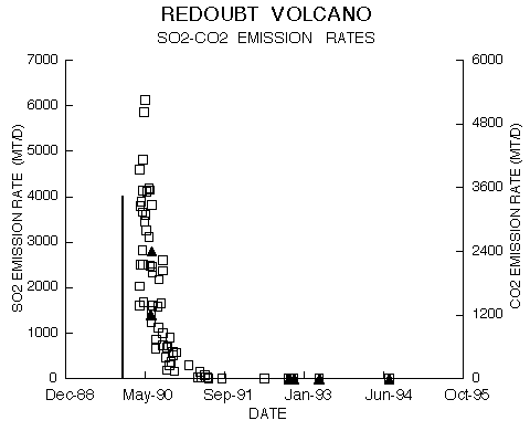
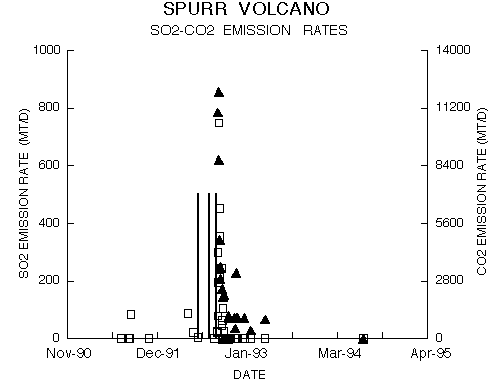
USGS Geoscience Data Catalog
Additional USGS Geoscience data can be found by geographic location or by publication series.
Doukas, Michael P. , 1995, A compilation of sulphur dioxide and carbon dioxide emission-rate data from Cook Inlet volcanoes (Redoubt, Spurr, Illiamna, and Augustine), Alaska during the period from 1990 to 1994: U.S. Geological Survey Open-File Report 95-55, U.S. Geological Survey, Anchorage, Alaska.Online Links:
Horizontal positions are specified in geographic coordinates, that is, latitude and longitude. Latitudes are given to the nearest 0.01. Longitudes are given to the nearest 0.01. Latitude and longitude values are specified in Decimal degrees.
| Range of values | |
|---|---|
| Minimum: | 0 |
| Maximum: | 6120 |
| Units: | metric tons per day |
| Resolution: | 1 |
| Range of values | |
|---|---|
| Minimum: | 0 |
| Maximum: | 12000 |
| Units: | metric tons per day |
| Resolution: | 10 |
(360) 696-7804 (voice)
mdoukas@usgs.gov
Airborne sulfur dioxide gas sampling of the Cook Inlet volcanoes (Redoubt, Spurr, Iliamna, and Augustine) began in 1986 when several measurements were carried out at Augustine volcano during the eruption of 1986. From March 1990 to October 1994, more than one hundred fixed-wing aircraft flights were made by the USGS in order to measure and characterize gas emissions from the Cook Inlet volcanoes.
A correlation spectrometer (COSPEC) was used to measure SO2. In some cases no SO2 plume was
detected by the instrument and a value of zero was reported as the SO2 rate. Even though SO2
may have been sensed by the operator's nose (more sensitive than the instrument), a rate of
zero was still reported. Typically, three to six traverses were made underneath the plume to
determine an average SO2 burden (concentration multiplied by the pathlength) within a
cross-section of the plume. Knowing the burden, the plume width and plume velocity (assumed to
be the same as ambient wind speed), the emission rate of SO2 was calculated. The resultant
value of SO2 is reported after values of more than one standard deviation from the average have
been removed. All emission rates are reported in metric tons/day (t/d) above the background
level upwind of the volcano.
Carbon dioxide in the Cook Inlet volcanic plumes was measured by an infrared spectrometer
(MIRAN) tuned to the 4.26 micrometers CO2 absorption band. Volcanic CO2 is defined as that
gas detected within a volcano's plume that is in excess of the concentration of ambient CO2 in
the atmosphere. Plume area, CO2 density at the mean altitude of the plume, and the plume
velocity (assumed to be equal to the ambient wind speed), were then used to calculate the CO2
emission rate. The resulting calculated CO2 emission rate represents one measurement, not an
average of several. During times of low emission rates and low wind speeds, orbits within a
kilometer of the vent were required, which gave low results because of slow instrumental
response times. Thus, some CO2 measurements reported here are indicated to be minimum values.
All emission rates are reported in metric tons/day (t/d) above the background level upwind of
the volcano.
SO2 measurement. In some cases, no SO2 plume was detected by the instrument and a value of zero was reported as the SO2 rate, eventhough SO2 may have been sensed by the operator's nose.
Three to six traverses were made underneath the plume to determine an average SO2 burden. The
calculated CO2 emission rate represents one measurement, not an average of several
measurements.
During times of low emission rates and low wind speeds, orbits within a kilometer of the vent
were required, which gave low results because of slow instrumental response times. Thus, some
CO2 measurements reported here are indicated to be minimum values.
Are there legal restrictions on access or use of the data?
- Access_Constraints: None
- Use_Constraints: None
(303) 202-4210 (voice)
(303) 236-4693 (FAX)
U.S. Geological Survey Open-File Report 95-55
This report is preliminary and has not been reviewed for conformity with U.S. Geological Survey editorial standards (or with the North American Stratigraphic Code). Any use of trade, product, or firm names is for descriptive purposes only and does not imply endorsement by the U.S. Government.
The full data set is published in paper form.
(703) 648-5285 (voice)
(703) 648-6560 (FAX)
kfoley@usgs.gov
U.S. Geological Survey Open-File Report 95-55
This report is preliminary and has not been reviewed for conformity with U.S. Geological Survey editorial standards (or with the North American Stratigraphic Code). Any use of trade, product, or firm names is for descriptive purposes only and does not imply endorsement by the U.S. Government.
| Data format: | The information is structured and formatted for retrieval using web browsers. in format TEXT tab-delimited |
|---|---|
| Network links: |
<http://pubs.usgs.gov/of/1995/of95-055/core/meta/tables/table1.tab> <http://pubs.usgs.gov/of/1995/of95-055/core/meta/tables/table2.tab> |
(703) 648-5285 (voice)
(703) 648-6560 (FAX)
kfoley@usgs.gov