Inventory of landslides triggered by the 1994 Northridge, California earthquake

Metadata also available as - [Outline] - [Parseable text] - [XML]

Frequently anticipated questions:


What does this data set describe?

Title:
Inventory of landslides triggered by the 1994 Northridge, California earthquake
Abstract:
The 17 January 1994 Northridge, California, earthquake (M=6.7) triggered more than 11,000 landslides over an area of about 10,000 km². Most of the landslides were concentrated in a 1,000-km² area that includes the Santa Susana Mountains and the mountains north of the Santa Clara River valley. We mapped landslides triggered by the earthquake in the field and from 1:60,000-scale aerial photography provided by the U.S. Air Force and taken the morning of the earthquake; these were subsequently digitized and plotted in a GIS-based format, as shown on the accompanying maps (which also are accessible via Internet). Most of the triggered landslides were shallow (1-5 m), highly disrupted falls and slides in weakly cemented Tertiary to Pleistocene clastic sediment. Average volumes of these types of landslides were less than 1,000 m³, but many had volumes exceeding 100,000 m³. Many of the larger disrupted slides traveled more than 50 m, and a few moved as far as 200 m from the bases of steep parent slopes. Deeper ( >5 m) rotational slumps and block slides numbered in the hundreds, a few of which exceeded 100,000 m³ in volume. The largest triggered landslide was a block slide having a volume of 8X10E06 m³. Triggered landslides damaged or destroyed dozens of homes, blocked roads, and damaged oil-field infrastructure. Analysis of landslide distribution with respect to variations in (1) landslide susceptibility and (2) strong shaking recorded by hundreds of instruments will form the basis of a seismic landslide hazard analysis of the Los Angeles area.
  1. How might this data set be cited?
    Harp, Edwin L., and Jibson, Randall W., 1995, Inventory of landslides triggered by the 1994 Northridge, California earthquake: U.S. Geological Survey Open-File Report 95-213.

    Online Links:

    Other_Citation_Details:
    Digital files of landslide map can be accessed off of the greenwood server both as HPGL2 graphics files and ARC/INFO GIS files.
  2. What geographic area does the data set cover?
    West_Bounding_Coordinate: -119.17
    East_Bounding_Coordinate: -118.13
    North_Bounding_Coordinate: 34.75
    South_Bounding_Coordinate: 34.0
  3. What does it look like?
    http://pubs.usgs.gov/of/1995/ofr-95-0213/plate1.gif (GIF)
    GIF of landslide deposits in the Northridge, California area
  4. Does the data set describe conditions during a particular time period?
    Calendar_Date: 1995
    Currentness_Reference:
    publication date
  5. What is the general form of this data set?
    Geospatial_Data_Presentation_Form: map
  6. How does the data set represent geographic features?
    1. How are geographic features stored in the data set?
      This is a vector data set.
    2. What coordinate system is used to represent geographic features?
      The map projection used is Transverse Mercator.
      Projection parameters:
      Scale_Factor_at_Central_Meridian: 0.9996
      Longitude_of_Central_Meridian: -117.0
      Latitude_of_Projection_Origin: 0.0
      False_Easting: 500000
      False_Northing: -4000000
      Planar coordinates are encoded using coordinate pair
      Planar coordinates are specified in meters
      The horizontal datum used is North American Datum of 1927.
      The ellipsoid used is Clarke 1866.
      The semi-major axis of the ellipsoid used is 6378206.4.
      The flattening of the ellipsoid used is 1/294.98.
  7. How does the data set describe geographic features?
    LANDSLIDE.PAT
    Locations of landslides (Source: OFR-95-0213)
    SLIDE
    Location of landslides (Source: OFR-95-0213)
    ValueDefinition
    0Corresponds to polygons in which landslides are not found, such as inliers
    1Corresponds to label points within landslide polygons

Who produced the data set?

  1. Who are the originators of the data set? (may include formal authors, digital compilers, and editors)
    • Edwin L. Harp
    • Randall W. Jibson
  2. Who also contributed to the data set?
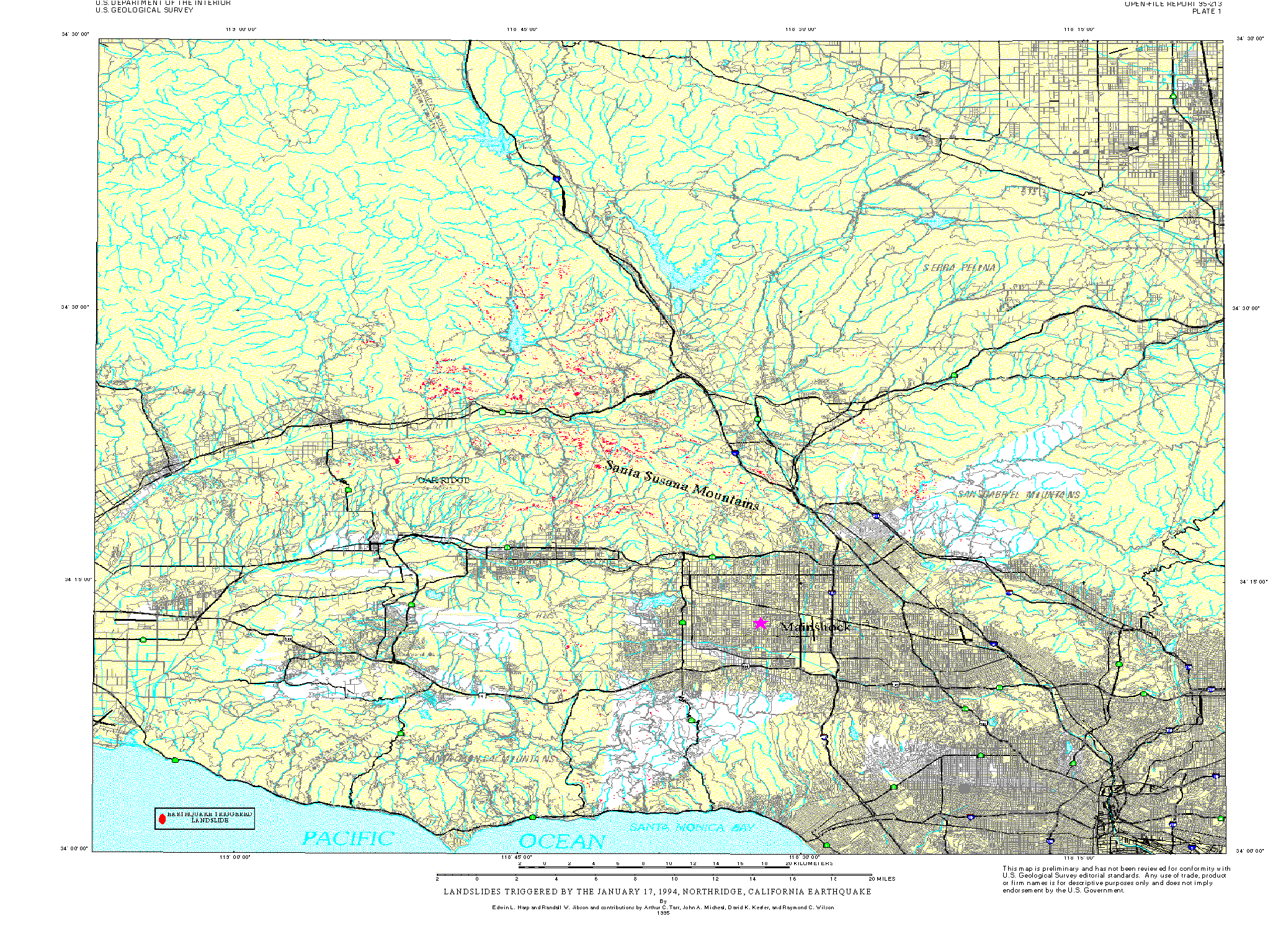
    David Keefer and Ray Wilson of the U.S. Geological Survey assisted in the post-earthquake reconnaissance efforts and in defining the landslide limits. John Michael and Art Tarr of the U.S. Geological Survey helped construct the digital landslide map. Al Barrows and Pam Irvine of the California Division of Mines and Geology, and Robert Larson of Los Angeles County provided useful information on the location and nature of many landslides triggered by the earthquake.
  3. To whom should users address questions about the data?
    Harp, Edwin L
    USGS-GEO-CRG-GHZ
    Mail Stop 966, USGS
    P.O. Box 25046
    Lakewood, CO
    US

    303-273-8557 (voice)
    harp@usgs.gov

Why was the data set created?

This extensive database will allow quantitative modeling of the relation between strong ground shaking, landslide susceptibility, and landslide distribution. The area of the greatest landslide concentration currently is undeveloped, but many parts of this area in the Santa Susana Mountains are slated for future dense residential development. We anticipate using the data and modeling results from the Northridge earthquake to produce regional maps of earthquake-induced landslide hazards that can be used to make informed decisions regarding development in the areas most susceptible to seismically triggered landsliding.

How was the data set created?

  1. From what previous works were the data drawn?
  2. How were the data generated, processed, and modified?
    Date: 1994 (process 1 of 2)
    We manually digitized the landslides mapped on the 1:24,000-scale base maps using the Arc/Info geographic information system (GIS). Landslides triggered by the earthquake are plotted as solid polygons on the digital inventory maps (plates 1 and 2).
    Date: 29-Aug-2000 (process 2 of 2)
    Creation of original metadata record Person who carried out this activity:
    Peter N Schweitzer
    U.S. Geological Survey, ER
    Geologist
    Mail Stop 954
    12201 Sunrise Valley Drive
    Reston, VA
    USA

    703-648-6533 (voice)
    703-648-6252 (FAX)
    pschweitzer@usgs.gov
  3. What similar or related data should the user be aware of?

How reliable are the data; what problems remain in the data set?

  1. How well have the observations been checked?
  2. How accurate are the geographic locations?
    We estimate that location accuracy of landslides mapped from the airphotos to the paper base maps is generally within 10 m and no worse than 20 m. When the paper maps were registered on the digitizer, the computer calculated the root-mean-square (RMS) error in the base-map registration, which averaged 3.6 m and ranged from 0.2 to 10.4 m. Thus, landslide locations plotted on plates 1 and 2 are generally accurate within about 15 m and are no more than 30 m mislocated.
  3. How accurate are the heights or depths?
  4. Where are the gaps in the data? What is missing?
    Landslides as small as 1-2 m across are visible where the slopes were sunlit;where slopes were partly shaded, slides about 5-10 m across are the smallest that could be resolved; thus, the inventory is not complete. However, our field observations indicate that south-facing slopes in most of the landslide area generally are steeper and produced far more landslides than north-facing slopes. Therefore, landslides on north-facing slopes that are not visible on the photos because of shadows probably account for only a small proportion of the total landslides. From our field investigations we estimate that we missed no more than about 20 percent of the landslides that exceeded 5 m in maximum dimension and no more than 50 percent of those smaller than 5 m. In terms of area, however, we estimate that we have mapped more than 90 percent of the area covered by triggered landslides, because most of the landslides that are not visible on the photos are small.
  5. How consistent are the relationships among the observations, including topology?
    The Northridge earthquake provided an unprecedented amount of data for studying the distribution and effects of landslides triggered by an earthquake in an urban area. Detailed field investigations to document earthquake-triggered landslides, which were initiated the day of the earthquake, are continuing. In the first several days following the earthquake, we drove outward from the epicentral area in all directions to locate areas of concentrated landsliding and to find the farthest extent of landsliding, which is defined by small rock and soil falls from very susceptible slopes such as steep road and stream cuts.
    High-altitude aerial photography (nominal scale 1:60,000) of the epicentral region was flown by the U.S. Air Force within hours of the earthquake, and we mapped fresh landslides visible on these photos to provide a detailed inventory of ground failures triggered by the earthquake. We mapped more than 11,000 individual landslides on 1:24,000-scale U.S.G.S. topographic base maps. The photos show all but the smallest slope failures and some that were hidden within deep shadows on the north sides of steep slopes.

How can someone get a copy of the data set?

Are there legal restrictions on access or use of the data?
Access_Constraints: none
Use_Constraints: none
  1. Who distributes the data set? (Distributor 1 of 1)
    USGS Information Services
    Box 25286, Denver Federal Center
    Denver, Colorado
    USA

    1-888-ASK-USGS (voice)
    1-303-202-4695 (FAX)
    infoservices@usgs.gov
  2. What's the catalog number I need to order this data set? US Geological Survey Open File Report 95-0213
  3. What legal disclaimers am I supposed to read?
    This report is preliminary and has not been reviewed for conformity with U.S. Geological Survey editorial standards or with the North American Stratigraphic Code. Any use of trade, product, or firm names is for descriptive purposes only and does not imply endorsement by the U.S. Government.
  4. How can I download or order the data?

Who wrote the metadata?

Dates:
Last modified: 05-Feb-2016
Last Reviewed: 31-Aug-2000
Metadata author:
Peter N Schweitzer
USGS Midwest Area
Collection manager, USGS Geoscience Data Clearinghouse, http://geo-nsdi.er.usgs.gov/
Mail Stop 954
12201 Sunrise Valley Dr
Reston, VA
USA

703-648-6533 (voice)
703-648-6252 (FAX)
pschweitzer@usgs.gov
Metadata standard:
Content for Digital Geospatial Metadata (FGDC-STD-001-1998)

This page is <https://geo-nsdi.er.usgs.gov/metadata/open-file/95-213/metadata.faq.html>
Generated by mp version 2.9.48 on Tue Jul 03 20:06:32 2018