Preliminary Geologic Map of the San Bernardino 30' x 60' quadrangle, California

Metadata also available as - [Outline] - [Parseable text] - [XML]

Frequently anticipated questions:


What does this data set describe?

Title:
Preliminary Geologic Map of the San Bernardino 30' x 60' quadrangle, California
Abstract:
The San Bernardino 30'x60' quadrangle, southern California, is diagonally bisected by the San Andreas Fault Zone, separating the San Gabriel and San Bernardino Mountains, major elements of California's east-oriented Transverse Ranges Province. Included in the southern part of the quadrangle is the northern part of the Peninsular Ranges Province and the northeastern part of the oil-producing Los Angeles basin. The northern part of the quadrangle includes the southern part of the Mojave Desert Province. Pre-Quaternary rocks within the San Bernardino quadrangle consist of three extensive, well-defined basement rock assemblages, the San Gabriel Mountains, San Bernardino Mountains, and the Peninsular Ranges assemblages, and a fourth assemblage restricted to a narrow block bounded by the active San Andreas Fault and the Mill Creek Fault. Each of these basement rock assemblages is characterized by a relatively unique suite of rocks that was amalgamated by the end of the Cretaceous and (or) early Cenozoic. Some Tertiary sedimentary and volcanic rocks are unique to specific assemblages, and some overlap adjacent assemblages. A few Miocene and Pliocene units cross the boundaries of adjacent assemblages, but are dominant in only one. Tectonic events directly and indirectly related to the San Andreas Fault system have partly dismembered the basement rocks during the Neogene, forming the modern-day physiographic provinces.
Rocks of the four basement rock assemblages are divisible into an older suite of Late Cretaceous and older rocks and a younger suite of post-Late Cretaceous rocks. The age span of the older suite varies considerably from assemblage to assemblage, and the point in time that separates the two suites varies slightly. In the Peninsular Ranges, the older rocks were formed from the Paleozoic to the end of Late Cretaceous plutonism, and in the Transverse Ranges over a longer period of time extending from the Proterozoic to metamorphism at the end of the Cretaceous. Within the Peninsular Ranges a profound diachronous unconformity marks the pre-Late Cretaceous-post-Late Cretaceous subdivision, but within the Transverse Ranges the division appears to be slightly younger, perhaps coinciding with the end of the Cretaceous or extending into the early Cenozoic. Initial docking of Peninsular Ranges rocks with Transverse Ranges rocks appears to have occurred at the terminus of plutonism within the Peninsular Ranges. During the Paleogene there was apparently discontinuous but widespread deposition on the basement rocks and little tectonic disruption of the amalgamated older rocks. Dismemberment of these Paleogene and older rocks by strike-slip, thrust, and reverse faulting began in the Neogene and is ongoing. The Peninsular Ranges basement rock assemblage is made up of the Peninsular Ranges batholith and a variety of metasedimentary rocks. Most of the plutonic rocks of the batholith are granodiorite and tonalite in composition; primary foliation is common, mainly in the eastern part. Tertiary sedimentary rocks of the Los Angeles Basin crop out in the Puente and San Jose Hills along with the spatially associated Glendora Volcanics; both units span the boundary between the Peninsular Ranges and San Gabriel Mountains basement rock assemblages.
The San Gabriel Mountains basement rock assemblage includes two discrete areas, the high standing San Gabriel Mountains and the relatively low San Bernardino basin east of the San Jacinto Fault. The basement rock assemblage is characterized by a unique suite of rocks that include anorthosite, Proterozoic and Paleozoic gneiss and schist, the Triassic Mount Lowe intrusive suite, extensive deformed and undeformed Cretaceous granitic rocks, the Pelona Schist, and Oligocene granitic rocks. Internal structure of the assemblage includes the Vincent Thrust Fault, at least two old, abandonded segments of the San Andreas Fault system, and extensive areas of well-developed to pervasively mylonitized rocks.
The main body of the San Gabriel Mountains is bounded on the north by the San Andreas Fault and on the south by the Sierra Madre-Cucamonga Fault Zone. East of the San Jacinto Fault, the San Bernardino basin is an asymmetric pull-apart basin bounded by the San Andreas Fault on the east, and underlain by many of the same rock units that characterize the San Gabriel Mountains. Cretaceous and older rocks of the San Gabriel Mountains basement rock assemblage are divided into two structurally and lithologically distinct groups by the Vincent Thrust Fault, a regional, low-angle thrust fault that predates intrusion of Oligocene granitic rocks. The Vincent Thrust separates the Mesozoic Pelona Schist in its lower plate from highly deformed gneiss, schist, and granitic rocks in the upper plate. The fault, along with its far-offset, dismembered analogs in the Orocopia and Chocolate Mountains east of the Salton Sea, may underlie much of southern California.
Crystalline rocks between the Mill Creek Fault and the main trace of the San Andreas Fault Zone range from highly deformed gneiss of unknown age to relatively undeformed Mesozoic biotite-hornblende diorite. They are overlain by Miocene sedimentary rocks and cut by the Wilson Creek Fault, that is considered to be an older segment of the San Andreas Fault system. Crystalline rocks of this basement assemblage are similar to rocks in the Little San Bernardino Mountains to the southeast, and appear to have been displaced about 50 km by the Wilson Creek and Mill Creek Faults.
About 80 to 85 percent of the San Bernardino Mountains bedrock assemblage in the quadrangle is Mesozoic granitic rocks, and the rest, highly metamorphosed and deformed Late Proterozoic and Paleozoic metasedimentary rocks. There is a pronounced gradient from east to west, and to a slightly lesser degree from south to north, in the magnitude of both deformation and metamorphism of the Late Proterozoic and Paleozoic metasedimentary rocks. In addition to the east to west gradient of increasing metamorphism and deformation, east of the quadrangle there appears to be a sharp break between highly deformed and relatively undeformed Late Proterozoic and Paleozoic rocks.
Late Proterozoic and Paleozoic units comprise a thick sequence of metasedimentary rocks generally consisting of a lower quartzitic sequence and an upper carbonate rock sequence. The entire lower quartzitic part is Late Proterozoic and Early Cambrian, and includes the Stirling Quartzite, Wood Canyon Formation and Zabriskie Quartzite; the upper carbonate rock sequence includes the Cambrian Carrara and Bonanza King Formations, the Devonian Sultan Limestone, the Mississippian Monte Cristo Limestone, and the Pennsylvanian Bird Spring Formation.
Mesozoic intrusive rocks in the San Bernardino Mountains and southern Mojave Desert include numerous Triassic and Jurassic plutons. The Triassic rocks are relatively alkalic and quartz deficient, and contrast with the voluminous, quartz-rich, calc-alkalic Cretaceous granitic rocks, which make up the largest part of the San Bernardino Mountains assemblage. The voluminous tonalitic rocks in the San Gabriel Mountains and Peninsular Ranges assemblages are essentially absent in the western San Bernardino Mountains. Many areas of dominantly Cretaceous granitic rocks are mapped as Mesozoic mixed-rock units, because they are extremely heterogeneous, and include large components of older rocks.
The relatively young, active San Andreas Fault system is by far the dominant structure in the San Bernardino quadrangle. Based on offsets of many of the rock units found in the San Bernardino quadrangle, different amounts of lateral displacement have been proposed for the San Andreas Fault system within and south of the Transverse Ranges. The Neogene evolution of the Transverse Ranges Province, and its relationship to the San Andreas Fault system in particular, are complicated by several abandonded segments and the shifting locus of the fault during the late Cenozoic. Most recent structural interpretations require relatively large rotations within the Transverse Ranges Province.
Other active faults in the quadrangle include the San Jacinto Fault and the reverse faults bounding and within the Transverse Ranges. Older faults considered to be abandoned segments of the San Andreas Fault system include the San Gabriel Fault, Punchbowl Fault, Mission Creek Fault, and Wilson Creek Fault. The Vincent Thrust and Squaw Peak Fault are both older faults, the Vincent probably of late Mesozoic to early Tertiary age.
Supplemental_Information:
The contents of this report consist of the following:
1. Geologic map database
2. Plot files for five sheets:
  Sheet 1 Geologic map
  Sheet 2 Correlation of Map Units
  Sheet 3 List of map units
  Sheet 4 Fault map
  Sheet 5 Three figures, including index map, physiographic provinces map, and sources of data
3. A pamphlet containing:
  a. A detailed Description of Map Units
  b. A discussion of the regional geologic framework
  c. Photographs of many rock units and geologic features
Map nomenclature: Within the geologic map database, map units are identified by standard geologic map criteria such as formation-name, age, and lithology. The authors have attempted to adhere to the stratigraphic nomenclature of the U.S. Geological Survey and the North American Stratigraphic Code, but the database has not received a formal editorial review of geologic names.
Map plot: Some contacts are very poorly located or are gradational over a very wide interval. Many of these contacts would normally be shown as scratch contacts, but at 1:100,000 scale lead to unclear map relationships. For the purposes of clarity, these scratch contacts are drawn on the map plot with a short dashed line. Dune crests within units Qoed3 and Qyed1 are mapped and recorded in the database, but are omitted from the geologic map plot file, because they obscure unit contacts. Dikes making up unit Kg are mapped and recorded in the database, but are omitted from the geologic map plot file because they are too concentrated and plot as a mass of indistinguishable lines. Intra-unit grain-size boundaries within generic Quaternary units are recorded in the database, but are in most cases poorly defined and poorly located, because the contacts are anastamosing and gradational. They also are omitted from the geologic map plot file.
  1. How might this data set be cited?
    Douglas M. Morton (compiler), and Fred K. Miller (compiler), 2003, Preliminary Geologic Map of the San Bernardino 30' x 60' quadrangle, California: U.S. Geological Survey Open-File report 03-293, U.S. Geological Survey, Menlo Park, California.

    Online Links:

  2. What geographic area does the data set cover?
    West_Bounding_Coordinate: -118.00593183
    East_Bounding_Coordinate: -116.99999913
    North_Bounding_Coordinate: 34.50409269
    South_Bounding_Coordinate: 33.99593574
  3. What does it look like?
    http://pubs.usgs.gov/of/2003/of03-293/images/sb.gif (GIF)
    Reduced-size image of the entire map sheet, 425x332 pixels, 72k bytes
    http://pubs.usgs.gov/of/2003/of03-293/sanbern_map.pdf (PDF)
    Navigable portable document format file (.pdf) image of the geologic map
  4. Does the data set describe conditions during a particular time period?
    Beginning_Date: 2001
    Ending_Date: 2003
    Currentness_Reference:
    Publication date
  5. What is the general form of this data set?
    Geospatial_Data_Presentation_Form: map
  6. How does the data set represent geographic features?
    1. How are geographic features stored in the data set?
      This is a Vector data set. It contains the following vector data types (SDTS terminology):
      • Point (20256)
      • String (51013)
      • GT-polygon composed of chains (20270)
    2. What coordinate system is used to represent geographic features?
      Grid_Coordinate_System_Name: Universal Transverse Mercator
      Universal_Transverse_Mercator:
      UTM_Zone_Number: 11
      Transverse_Mercator:
      Scale_Factor_at_Central_Meridian: 1.0
      Longitude_of_Central_Meridian: -117.50
      Latitude_of_Projection_Origin: 34.00
      False_Easting: 0
      False_Northing: 0
      Planar coordinates are encoded using coordinate pair
      Abscissae (x-coordinates) are specified to the nearest 0.000000191346
      Ordinates (y-coordinates) are specified to the nearest 0.000000191346
      Planar coordinates are specified in Meters
      The horizontal datum used is North American Datum of 1927.
      The ellipsoid used is Clarke 1866.
      The semi-major axis of the ellipsoid used is 6378206.4.
      The flattening of the ellipsoid used is 1/294.98.
  7. How does the data set describe geographic features?
    Entity_and_Attribute_Overview:
    Version 1.0 of the San Bernardino 30' x 60' quadrangle comprises nine ARC/INFO coverages, of which four contain geologic data, one contains cartographic features, three provide base-map, DLG-derived, reference data, and one contains the distribution of constituent 7.5' quadrangles: sanbern_geo (geology), sanbern_str (structural point data, fold axis and line ornamentation), sanbern_dk (dikes as linear elements), sanbern_flt (faults and annotation), sanbern_carto (geologic unit annotation, locality names), snbrn_hypso (hypsography), snbrn_hydro (hydrography), snbrn_transp (transportation and cultural data), and snbrn_quds (32 constituent 7.5' quadrangles).
    In addition to the customary software-defined attributes in each feature attribute table, user-defined attributes are included that allow the user access to more detailed geologic information including unit name, grain size where applicable, and rock assemblage. Two lookup tables are included: rockunit_color.lut (rockunit color assignment) and rockunit_pattern.lut (rockunit pattern assignment).
    Entity_and_Attribute_Detail_Citation: http://pubs.usgs.gov/of/2003/of03-293/SB100K_pamphlet.pdf
    sanbern_geo.pat
    Polygon feature attribute table that stores alphanumeric symbols for units that characterize lithologic type and age of earth materials represented by each polygon, color assignment, unit name, subunit, and grain-size where applicable.
    LABL
    Rock-unit label
    ValueDefinition
    CbkBonanza King Formation
    CcCarrara Formation
    CwWood Canyon Formation
    CzZabriskie Quartzite
    DsSultan Limestone
    JTrgbGabbro and pyroxenite
    JaGranodiorite of Arrowhead Peak
    JcLeucocratic quartz monzonite of Crystal Creek
    JcrCataclastic rocks
    JdQuartz monzodiorite of Dry Canyon
    JgfGranodiorite and quartz monzonite of Fern Canyon
    JhcQuartz monzodiorite of Hutak Canyon
    JrrBiotite quartz monzodiorite of Redonda Ridge
    JsLeucocratic hornblende syenite
    JscFine-grained rocks of Silver Canyon
    JwmMonzodiorite of White Mountain
    KJcQuartz monzodiorite of Crestline
    KJddQuartz monzonite of Dawn O'Day Canyon
    KJdgMixed diorite and gabbro
    KJgmMixed granitic rocks, gneiss, and quartzite
    KJhbHornblende-biotite granodiorite
    KJhsMixed granitic rocks of Hopi Spring
    KJosMixed granitic rocks of Oak Spring
    KJqdQuartz-bearing diorite
    KJscQuartz diorite of Sand Canyon
    KJspMixed granitic rocks of South Peak
    KJtaTonalite of Ord Mountains
    KPrmMylonitic orthogneiss related to Vincent Thrust Fault
    KPzsgSchist, gneiss, monzogranite, and granodiorite
    KPzstSchist, gneiss, and tonalite
    KPzt1sMixed tonalite, Unit 1 and schist
    KPztmMixed tonalite and marble
    KPztmsMixed tonalite, marble, and schist
    KPztsMixed tonalite and biotite schist
    KTrmmMixed monzogranite and leucocratic monzonite
    KaoGranodiorite of Angeles Oaks
    KawAlaskite of western Granite Mountains
    KbfMonzogranite of Burnt Flats
    KbfgBox Springs plutonic complex, biotite granodiorite and tonalite
    KbfgiBox Springs plutonic complex, biotite granodiorite and tonalite containing abundant inclusions
    KbftBox Springs plutonic complex, biotite-hornblende tonalite
    KbgBox Springs plutonic complex, porphyritic granodiorite
    KbgtBox Springs plutonic complex, heterogeneous granodiorite and tonalite
    KbhgBox Springs plutonic complex, heterogeneous porphyritic granodiorite
    KbhtBox Springs plutonic complex, heterogeneous biotite tonalite
    KbmHeterogeneous, leucocratic biotite monzogranite
    KbpMonzogranite of Butler Peak
    KbtBox Springs plutonic complex, biotite tonalite
    KccMonzogranite of City Creek
    KcdSedimentary rocks of Cosy Dell area
    KcdcSedimentary rocks of Cosy Dell area, conglomerate
    KchCharnockite
    KcmTonalite of Circle Mountain
    KcrMonzogranite of Coxey Road
    KcsMonzogranite of Cloudburst Summit
    KcslMonzogranite of Cloudburst Summit, leucocratic unit
    KdDiorite, undifferentiated
    KdcGranodiorite of Dorr Canyon
    KddDeer diorite of Alf (1948)
    KdhMonzogranite of Devils Hole
    KdpMonzogranite of Deadman Point
    KdqdDiorite and quartz diorite, undifferentiated
    KehTonalite of Elephant Hill
    KgGranitic dikes, undifferentiated
    KgbGabbro
    KgcMylonitized leucogranite
    Kgd1Granodiorite, Unit 1
    KgdbBiotite granodiorite
    KgdcBiotite granodiorite, Cajon area
    KgdpGranodiorite
    KgdtGranodiorite and tonalite, undifferentiated
    KglMixed leucocratic and granitic rocks
    KgpTonalite of Ganesha Park
    KhGranodiorite of Hanna Flat
    KhcGranodiorite of Hook Creek
    KhlHeterogeneous leucocratic granitic rocks
    KhrHybrid rocks
    KhtHeterogeneous tonalite
    KkMonzogranite of Keller Peak
    KkcMonzogranite of Kinley Creek
    KlLeucocratic granitic rocks
    KlgLeucocratic granite dikes
    KlmgLeucocratic muscovite monzogranite
    KlvHeterogeneous granitic rocks of La Verne area
    KmbbBiotite monzogranite
    KmcMonzogranite of Malony Creek
    KmgMonzogranite and granodiorite
    KmgtMonzogranite and tonalite, undivided
    KmlMixed mafic and leucocratic granitic rocks
    KmpMonzogranite
    KmsMonzogranite of Muddy Spring
    KmxMixed granitic rocks of Heaps Peak
    KpgMonzogranite of Punchbowl Fault area
    KpmPorphyritic biotite monzogranite
    KrRattlesnake Mountain pluton of MacColl (1964), even-grained monzogranite
    KrlLeucocratic rocks of Rattlesnake Mountain pluton of MacColl (1964)
    KrpRattlesnake Mountain pluton of MacColl (1964), porphyritic monzogranite
    KsaQuartz diorite of Mount San Antonio
    KsgrTonalite of San Gabriel Reservoir
    KssTonalite of San Sevaine Lookout
    KssgMixed tonalite of San Sevaine Lookout and gneiss
    KssmMylonitized tonalite of San Sevaine Lookout
    Kssm1Mylonitized tonalite of San Sevaine Lookout, Unit 1
    KtTonalite
    KwcGranodiorite of Willow Creek
    KwcyMonzogranite of Willow Canyon
    MmMonte Cristo Limestone
    MzPrbMixed metamorphic and granitic rocks of Big Dalton Canyon
    MzPrdGneiss of Devil Canyon
    MzPrlMixed granitic rocks, quartzite, and schist of Lizard Springs
    MzPrmMixed granitic and metamorphic rocks
    MzPzmMixed granitic and metasedimentary rocks, and gneiss
    MzcDiorite of Cram Peak
    MzdyDiorite, Yucaipa area
    MzfgFoliated granitoid rocks
    MzgGranitoid rocks
    MzgaOrthogneiss of Alger Creek
    MzgdGneissic granodiorite of Holcomb Ridge
    MzggmFoliated gabbro, granodiorite, and monzogranite
    MzgrBiotite monzogranite of Big John Peak
    MzgyMesocratic granitoid rocks
    MzhMonzogranite and granodiorite of Holcomb Ridge
    MzhgHeterogeneous granitic rocks, San Gabriel Mountains
    MziInclusion-rich granitoid rocks
    MzmgMylonitic and cataclastic granitoid rocks
    MzmxMixed mafic rocks and monzogranite
    MzogHeterogeneous hornblende-biotite orthogneiss
    MzpPelona Schist, undifferentiated
    MzpaPelona Schist, amphibolite grade unit
    MzpbPelona Schist, biotite-quartz schist unit
    MzpgPelona Schist, greenstone unit
    MzpmPelona Schist, marble unit
    MzpqPelona Schist quartzite unit
    MzprGneiss of Pinyon Ridge
    MzpsPelona Schist, muscovite schist unit
    MzslMixed granitic rocks of Silverwood Lake
    MzuMesozoic granitic rocks, undivided
    PPbsBird Spring Formation
    PraAnorthosite
    CPrccShay Mountain metamorphic complex of MacColl (1964), biotite schist of Cox Creek
    PrgcCoarse-grained biotite granite augen gneiss
    PrgdFoliated to gneissic granodiorite
    PrgmMedium-grained biotite granite augen gneiss
    PrgnLayered gneiss, undifferentiated
    Prgn1Layered gneiss, Unit 1
    Prgn2Layered gneiss, Unit 2
    Prgn3Layered gneiss, Unit 3
    Prgn4Layered gneiss, Unit 4
    Prgn5Layered gneiss, Unit 5
    Prgn6Layered gneiss, Unit 6
    PrgndDioritic gneiss or amphibolite
    CPrgsqShay Mountain metamorphic complex of MacColl (1964), mixed gneiss, schist and quartzite
    PrgtPelitic gneiss of Troop Peak
    PrguGranulitic gneiss, mylonite, and cataclasite
    CPrlsmShay Mountain metamorphic complex of MacColl (1964), Quartzite of Little Shay Mtn
    PrmGranulitic gneiss, mylonite, and cataclasite, retrograde
    PrpvGneiss of Pleasant View Ridge
    PrpvaGneiss of Pleasant View Ridge, augen gneiss
    CPrqcShay Mountain metamorphic complex of MacColl (1964), quartzite and calcsilicate rocks of Little Pine Flat
    PrscStirling Quartzite, carbonate-rich rocks
    PrscqStirling Quartzite, carbonate and quartzite member
    CPrsmShay Mountain metamorphic complex of MacColl (1964), Gneiss of Shay Mountain
    PrsqStirling Quartzite, quartzite member
    PrsuStirling Quartzite
    PzaAmphibolite
    PzmbMarble, San Bernardino Mountains
    PzmgMarble, San Gabriel Mountains
    PzmpMarble, Peninsular Ranges
    PzqgQuartzite, San Gabriel Mountains
    PzsgMetasedimentary schist and gneiss, San Gabriel Mountains
    PzspBiotite schist and gneiss, Peninsular Ranges
    QTfzCrushed rock in fault zones
    QTjhJuniper Hills Formation, undifferentiated
    QTjhaJuniper Hills Formation, arkosic sandstone unit
    QTjhbJuniper Hills Formation, arkosic breccia unit
    QTjhcJuniper Hills Formation, clay-shale unit
    QTjhcsJuniper Hills Formation, conglomeratic sandstone unit
    QTjhfJuniper Hills Formation, fine-grained unit
    QTjhpJuniper Hills Formation, playa deposit unit
    QTjhrJuniper Hills Formation, red arkose unit
    QTjhsJuniper Hills Formation, siltstone unit
    QTjhsbJuniper Hills Formation, sedimentary breccia unit
    QTjhvJuniper Hills Formation, volcanic clast unit
    QTppPhelan Peak deposits of Weldon (1984), undifferentiated
    QTpp3Phelan Peak deposits of Weldon (1984), Unit 3
    QTsConglomerate, conglomeratic arkose, and clayey arkose
    QTstcqSan Timoteo beds of Frick (1921), quartzite-bearing conglomerate member
    QTstrSan Timoteo beds of Frick (1921), Reche Canyon member
    QTstuSan Timoteo beds of Frick (1921), upper member
    QaVery young alluvial-valley deposits
    Qa1Very young alluvial-valley deposits, Unit 1
    QabVery young alluvial-valley deposits
    QacVery young alluvial-valley deposits
    QafArtificial fill
    QbSedimentary breccia of Meisling (1984)
    QcVery young colluvial deposits
    QdgDisturbed ground
    QeVery young eolian deposits
    QfVery young alluvial-fan deposits
    Qf1Very young alluvial-fan deposits, Unit 1
    Qf1bVery young alluvial-fan deposits, Unit 1
    Qf2Very young alluvial-fan deposits, Unit 2
    Qf2bVery young alluvial-fan deposits, Unit 2
    QfbVery young alluvial-fan deposits
    QfgVery young alluvial-fan deposits
    QhHarold Formation
    QlVery young lacustrine deposits
    QlsVery young landslide deposits
    QoaOld alluvial-valley deposits
    Qoa1Old alluvial-valley deposits, Unit 1
    Qoa2Old alluvial-valley deposits, Unit 2
    Qoa3Old alluvial-valley deposits, Unit 3
    QocOld colluvial deposits
    QoeOld eolian deposits
    Qoed3Old eolian deposits (dune sand), Unit 3
    Qoes3Old eolian deposits (sheet sand), Unit 3
    QofOld alluvial-fan deposits
    Qof1Old alluvial-fan deposits, Unit 1
    Qof1aOld alluvial-fan deposits, Unit 1
    Qof1bOld alluvial-fan deposits, Unit 1
    Qof2Old alluvial-fan deposits, Unit 2
    Qof2aOld alluvial-fan deposits, Unit 2
    Qof2bOld alluvial-fan deposits, Unit 2
    Qof2sOld alluvial-fan deposits, Unit 2
    Qof3Old alluvial-fan deposits, Unit 3
    Qof3sOld alluvial-fan deposits, Unit 3
    QofaOld alluvial-fan deposits
    QofagOld alluvial-fan deposits
    QofbOld alluvial-fan deposits
    QofcOld alluvial-fan deposits
    QofgOld alluvial-fan deposits
    QofgaOld alluvial-fan deposits
    QofgbOld alluvial-fan deposits
    QofsOld alluvial-fan deposits
    QolbOld lacustrine deposits (bar)
    QolsOld landslide deposits
    QosOld surficial deposits
    QpVery young playa deposits
    Qp1Very young playa deposits, Unit 1
    QsVery young surficial deposits
    Qs1Very young surficial deposits, Unit 1
    QsgVery young surficial deposits
    QshShoemaker Gravel
    QswVery young slope-wash deposits
    QtVery young talus deposits
    QvoaVery old alluvial-valley deposits
    Qvoa1Very old alluvial-valley deposits, Unit 1
    Qvoa2Very old alluvial-valley deposits, Unit 2
    Qvoa3Very old alluvial-valley deposits, Unit 3
    QvoabVery old alluvial-valley deposits
    QvofVery old alluvial-fan deposits
    Qvof1Very old alluvial-fan deposits, Unit 1
    Qvof1agVery old alluvial-valley deposits, Unit 1
    Qvof1bVery old alluvial-fan deposits, Unit 1
    Qvof1gVery old alluvial-fan deposits, Unit 1
    Qvof2Very old alluvial-fan deposits, Unit 2
    Qvof2bVery old alluvial-fan deposits, Unit 2
    Qvof2gVery old alluvial-fan deposits, Unit 2
    Qvof3Very old alluvial-fan deposits, Unit 3
    QvofagVery old alluvial-fan deposits
    QvofbVery old alluvial-fan deposits
    QvofgVery old alluvial-fan deposits
    QvolsVery old landslide deposits
    QvolsaVery old landslide deposits
    QvorVery old regolith and (or) pedogenic soil
    QvosVery old surficial deposits
    QvoswVery old slope-wash deposits
    QwVery young wash deposits
    Qw1Very young wash deposits, Unit 1
    Qw1aVery young wash deposits, Unit 1
    Qw1gVery young wash deposits, Unit 1
    Qw2Very young wash deposits, Unit 2
    Qw3Very young wash deposits, Unit 3
    QwagVery young wash deposits
    QwbVery young wash deposits
    QwgVery young wash deposits
    QyaYoung alluvial-valley deposits
    Qya1Young alluvial-valley deposits, Unit 1
    Qya2Young alluvial-valley deposits, Unit 2
    Qya3Young alluvial-valley deposits, Unit 3
    Qya4Young alluvial-valley deposits, Unit 4
    Qya5Young alluvial-valley deposits, Unit 5
    QyaaYoung alluvial-valley deposits
    QycYoung colluvial deposits
    QyeYoung eolian deposits
    Qyed1Young eolian deposits (dune sand), Unit 1
    Qyes1Young eolian deposits (sheet-sand), Unit 1
    QyfYoung alluvial-fan deposits
    Qyf1Young alluvial-fan deposits, Unit 1
    Qyf1bYoung alluvial-fan deposits, Unit 1
    Qyf2Young alluvial-fan deposits, Unit 2
    Qyf2aYoung alluvial-fan deposits, Unit 2
    Qyf2bYoung alluvial-fan deposits, Unit 2
    Qyf3Young alluvial-fan deposits, Unit 3
    Qyf3aYoung alluvial-fan deposits, Unit 3
    Qyf3agYoung alluvial-fan deposits, Unit 3
    Qyf3bYoung alluvial-fan deposits, Unit 3
    Qyf3cYoung alluvial-fan deposits, Unit 3
    Qyf3csYoung alluvial-fan deposits, Unit 3
    Qyf3gaYoung alluvial-fan deposits, Unit 3
    Qyf3sYoung alluvial-fan deposits, Unit 3
    Qyf3scYoung alluvial-fan deposits, Unit 3
    Qyf3sgYoung alluvial-fan deposits, Unit 3
    Qyf4Young alluvial-fan deposits, Unit 4
    Qyf4bYoung alluvial-fan deposits, Unit 4
    Qyf4gYoung alluvial-fan deposits, Unit 4
    Qyf5Young alluvial-fan deposits, Unit 5
    Qyf5bYoung alluvial-fan deposits, Unit 5
    Qyf5gaYoung alluvial-fan deposits, Unit 5
    QyfaYoung alluvial-fan deposits
    QyfagYoung alluvial-fan deposits
    QyfbYoung alluvial-fan deposits
    QyfcYoung alluvial-fan deposits
    QyfgYoung alluvial-fan deposits
    QyfgbYoung alluvial-fan deposits
    QyfsYoung alluvial-fan deposits
    QylsYoung landslide deposits
    QypYoung playa deposits
    QysYoung surficial deposits
    QyswYoung slope-wash deposits
    QytYoung talus deposits
    QywYoung wash deposits
    Qyw1Young wash deposits, Unit 1
    Qyw2Young wash deposits, Unit 2
    Qyw3Young wash deposits, Unit 3
    QywbYoung wash deposits
    TKmgMafic granodiorite
    TMztpPelona Schist and granodiorite of Telegraph Peak
    TaAndesite dike rocks
    TadAndesite dikes
    TavAnaverde Formation, undifferentiated
    TavbAnaverde Formation, pale-tan arkose unit
    TavcAnaverde Formation, clay-shale unit
    TavrAnaverde Formation, red arkose unit
    TavwAnaverde Formation, white arkose unit
    TazSedimentary rocks of Azusa area
    TazcSedimentary rocks of Azusa area, conglomerate
    TbBasalt dikes
    TccConglomerate of Crestline
    TcdConglomerate and sandstone, San Sevaine Canyon area
    TcfConglomerate of Fredalba
    TcrCrowder Formation
    Tcr1Crowder Formation, Unit 1
    Tcr2Crowder Formation, Unit 2
    Tcr3Crowder Formation, Unit 3
    Tcr4Crowder Formation, Unit 4
    Tcr5Crowder Formation, Unit 5
    TcuConglomerate and arkose, undifferentiated
    Tcv1Cajon Valley Formation, Unit 1
    Tcv2Cajon Valley Formation, Unit 2
    Tcv3Cajon Valley Formation, Unit 3
    Tcv4Cajon Valley Formation, Unit 4
    Tcv5Cajon Valley Formation, Unit 5
    Tcv5aCajon Valley Formation, Unit 5a
    Tcv6Cajon Valley Formation, Unit 6
    TdDacite dikes
    TdcDuarte conglomerate of Shelton (1946)
    TdgOlivine diabase and gabbro
    TflFernando Formation, lower member
    TflcFernando Formation, lower member, comglomerate
    TfuFernando Formation, upper member
    TfucFernando Formation, upper member, conglomerate
    TgGlendora Volcanics, undifferentiated
    TgaGlendora Volcanics, andesite flows
    TgbGlendora Volcanics, basalt flows
    TgbtGlendora Volcanics, palagonitic tuff and pillow lava
    TgcGlendora Volcanics, volcanic conglomerate
    TgfGlendora Volcanics, fine-grained andesite
    TghHypabyssal granitic rocks
    TgiGlendora Volcanics, andesite dikes
    TgjGlendora Volcanics, tuff breccia of Johnson Peak area
    TgrGlendora Volcanics, rhyolite and dacite flows
    TgrbGlendora Volcanics, rhyolite and dacite breccia
    TgryGranodiorite, Yucaipa area
    TmaMill Creek Formation of Gibson (1971), arkose unit
    TmcpMill Creek Formation of Gibson (1971), Pelona Schist-bearing conglomerate unit
    TmcvMill Creek Formation of Gibson (1971), volcanic-clast-bearing unit
    TmdMountain Meadows Dacite
    TmmMill Creek Formation of Gibson (1971), mudstone unit
    TmsMill Creek Formation of Gibson (1971), sandstone unit
    TpPuente Formation, undifferentiated
    TpbbPunchbowl Formation, breccia unit
    TpbdPunchbowl Formation, diorite-clast unit
    TpbvPunchbowl Formation, volcanic clast unit
    TplsSoquel and La Vida Members, undifferentiated
    TplvPuente Formation, La Vida Member
    Tpp1Phelan Peak deposits of Weldon (1984), Unit 1
    Tpp2Phelan Peak deposits of Weldon (1984), Unit 2
    TpscPuente Formation, Sycamore Canyon Member
    TpsccPuente Formation, Sycamore Canyon Member, conglomerate
    TpsqPuente Formation, Soquel Member
    TpsqcPuente Formation, Soquel Member, conglomerate
    TpyPuente Formation, Yorba Member
    TrRhyolite porphyry dikes
    TraAlaskite of Sunset Cove
    TrcpMonzonite of Cedarpines Park
    TrdgDiorite and gabbro of Bare Mountain
    TrfMonzonite of Fawnskin
    TrflLeucocratic monzonite of Fawnskin
    TrfpMonzonite of Fifteenmile Point
    TrhMonzonite of Hill 4001
    TrlbMount Lowe Intrusive Suite, equigranular leucocratic biotite quartz monzonite
    TrlhMount Lowe Intrusive Suite, hornblende-biotite quartz monzonite
    TrllMount Lowe Intrusive Suite, porphyritic biotite quartz monzonite
    TrlmFine-grained leucocratic monzonite
    TrlqMount Lowe Intrusive Suite, porphyritic quartz monzonite and quartz monzodiorite
    TrluMount Lowe Intrusive Suite, undifferentiated
    TrmMonzogranite of Manzanita Springs
    TrrlMonzonite of Rabbit Lake
    TrspQuartz monzonite of Strawberry Peak
    TsMixed marine and nonmarine sedimentary rocks
    TsaSanta Ana Sandstone
    TsfSan Francisquito Formation
    TsfbSan Francisquito Formation, basal boulder conglomerate unit
    TsfcSan Francisquito Formation, conglomerate unit
    TsflSan Francisquito Formation, limestone lenses
    TsfsSan Francisquito Formation, shale unit
    TsgConglomerate, sandstone, and arkose
    TstlSan Timoteo beds of Frick (1921), lower member
    TtdHypabyssal dikes
    TtpGranodiorite of Telegraph Peak
    TvVaqueros Formation
    TvcVolcaniclastic conglomerate
    TvtVasquez Formation, tuffaceous rocks
    TvvVasquez Formation
    TwFormation of Warm Springs Canyon
    cgmChloritized cataclastic granitic rock
    cruCrystalline rocks, undifferentiated
    dgmDiorite gneiss and migmatite
    gbGabbro
    ggGneissic granitoid rocks and gneiss
    gnMixed metamorphic rocks of Ord Mountains area, gneiss
    gnbGneiss of Blue Cut area
    gnmCataclastic gneiss
    grGranitic rocks, undifferentiated
    mmMixed metamorphic rocks of Ord Mountains area, marble dominant
    mmcMixed metamorphic rocks of Ord Mountains area, marble and calcsilicate rock
    mmsMixed metamorphic rocks of Ord Mountains area, marble and schist dominant
    mqMixed metamorphic rocks of Ord Mountains area, quartzite dominant
    msMixed metamorphic rocks of Ord Mountains area, schist dominant
    mxMixed metamorphic rocks of Ord Mountains area, mixed
    water bodywater body
    UNITNAME
    Rock-unit name
    SUBUNIT
    Subdivisions of units with more than one component
    GRAIN_SIZE
    Characterizes grain-size of mapped Quaternary units where applicable.
    ASSEMBLAGE
    Identifies within which of the principle structural blocks a unit is located.
    sanbern.aat
    Geologic contacts, faults, and map boundary.
    L-SYMB
    Integer symbol (listed below along with line descriptions) that relates arc to cartographic line symbol in lineset: geoscamp2.lin
    L-NAME
    Formal name of fault feature
    DESCR
    Summary description of line type
    ValueDefinition
    3Contact, scratch, poorly located or gradational over hundreds of meters
    0Pegmatite and granitic dikes
    0Sand dune crests identified from aerial photographs; accurately located
    0intra-unit grain-size boundary
    1Contact; accurately located
    1Crown scarps formed by landsliding; accurately located
    1Dike rocks
    1cartographic, map boundary
    4Scarps produced by sequential stream downcutting; accurately located
    5water body: Lake Arrowhead
    5water body: Silverwood Lake
    5water body
    11Crown scarp, landslide
    50Fault, normal slip; accurately located
    50Fault, reverse slip; accurately located
    50Fault-line scarp, reverse slip on eroded fault; approximately located
    50Fault-line scarp, slip unspecified on eroded fault; accurately located
    50High-angle fault, left oblique slip; accurately located
    50High-angle fault, scarp, normal slip; accurately located
    50High-angle fault, scarp, oblique slip; accurately located
    50High-angle fault, scarp, reverse slip; accurately located
    50High-angle fault, scarp, slip unspecified; accurately located
    50High-angle fault, slip unspecified; accurately located
    50Left-lateral strike-slip fault; accurately located
    50Right-lateral strike-slip fault, scarp; accurately located
    50Right-lateral strike-slip fault; accurately located
    50Right-lateral strike-slip fault; concealed beneath mapped covering unit
    50Thrust fault, older over younger; accurately located
    50Thrust fault, older over younger; concealed beneath mapped covering unit
    5252
    52Fault, reverse slip; approximately located
    52High-angle fault, right oblique slip; approximately located
    52High-angle fault, scarp, slip unspecified; approximately located
    52High-angle fault, slip unspecified; approximately located
    52Left-lateral strike-slip fault; approximately located
    52Right-lateral strike-slip fault; approximately located
    53Fault, reverse slip; concealed beneath mapped covering unit
    53Fault, inferred by indirect methods; concealed beneath mapped covering unit
    53Fault, normal slip; concealed beneath mapped covering unit
    53Fault, reverse slip, concealed beneath mapped covering unit
    53Fault, reverse slip; concealed beneath mapped covering unit
    53High-angle fault, left oblique slip; concealed beneath mapped covering unit
    53High-angle fault, right oblique slip; concealed beneath mapped covering unit
    53High-angle fault, slip unspecified; concealed beneath mapped covering unit
    53Left-lateral strike-slip fault; concealed beneath mapped covering unit
    53Right-lateral strike-slip fault; concealed beneath mapped covering unit
    53Thrust fault, older over younger; concealed beneath mapped covering unit
    113Thrust fault, older over younger; accurately located
    113Thrust fault, scarp, older over younger; accurately located
    115Thrust fault, older over younger; approximately located
    116Thrust fault, older over younger; concealed beneath mapped covering unit
    128Fault, variable angle, rotational slip; accurately located
    131Fault, variable angle, rotational slip; concealed beneath mapped covering unit
    137Fault, intruded; preintrusive existence inferred
    211Topographic lineament formed by aligned saddles, swales and breaks in slope; accurately located
    sanbern_str.pat
    Planar structural point data showing bedding and foliation orientation (strike, dip, direction of dip);qualitative point data - fold axes line ornamentation.
    sanbern_str.aat
    Arc attribute table containing fold axes - monocline.
    sanbern_dk.aat
    Dikes
    sanbern_flt.aat
    Faults: contains same information as sanbern_geo.aat. However, due to the complexity of regional fault distribution, we feel it is useful to include the faults in a separate coverage. Coverage contains (1) faults, (2) cartographic elements as (a) fault name annotation, (b) fault-plane dip values; (3) line ornamentation as point symbols.
    snbrn_carto
    Cartographic elements: geologic unit labels (anno.geo), leaders, locality information (anno.locality), names of major water bodies (anno.water_body).

Who produced the data set?

  1. Who are the originators of the data set? (may include formal authors, digital compilers, and editors)
    • Douglas M. Morton (compiler)
    • Fred K. Miller (compiler)
  2. Who also contributed to the data set?
    Technical review by Paul Stone led to significant improvements that eventually were reflected in aspects of the database, the plot file, and in the discussion of the regional geologic framework and the description of the geologic units of the San Bernardino 30' X 60' quadrangle.
    Geologic mapping and digital preparation of this report were sponsored jointly by (1) the National Cooperative Geologic Mapping Program of the U.S. Geological Survey, and (2) the Southern California Areal Mapping Project (SCAMP).
  3. To whom should users address questions about the data?
    Douglas M. Morton
    U.S. Geological Survey, Western Region, Earth Surface Processes Team
    Project geologist
    U.S. Geological Survey
    Department of Earth Sciences
    University of California, Riverside
    Riverside, California
    United States of America

    (909) 276-6397 (voice)
    (909) 276-6295 (FAX)
    scamp@usgs.gov

Why was the data set created?

The data set for the San Bernardino 30'x60' quadrangle has been prepared by the Southern California Areal Mapping Project (SCAMP), a cooperative project sponsored jointly by the U.S. Geological Survey and the California Geological Survey. The San Bernardino data set represents part of an ongoing effort to create a regional GIS geologic database for southern California. This regional digital database, in turn, is being developed as a contribution to the National Geologic Map Database of the National Cooperative Geologic Mapping Program of the USGS. The San Bernardino quadrangle database has been prepared in cooperation with the National Forest Service, as part of an ongoing project to provide the San Bernardino National Forest with a geologic map base for use in managing National Forest resources and in developing interpretive materials.

How was the data set created?

  1. From what previous works were the data drawn?
    Barrows, 1980 (source 1 of 22)
    Barrows, A.G., 1980, Geologic map of the San Andreas Fault Zone, Juniper Hills and vicinity, Los Angeles County, California: California Division of Mines and Geology (CDMG) Open-File Reports CDMG OF80-2 L.A..

    Type_of_Source_Media: paper
    Source_Scale_Denominator: 9600
    Source_Contribution:
    Contributed new geologic and structural data for, and adjacent to, the San Andreas Fault in the Juniper Hills 7.5' quadrangle, part of San Bernardino quadrangle. Minor to moderate simplifications throughout map area, mainly deletion of very small (at 1:9,600 scale) polygons of bedrock in areas of extensive Quaternary deposits. Also, minor to moderate alterations of fault traces, mainly San Andreas and Nadeau Faults.
    Barrows, 1985 (source 2 of 22)
    Barrows, A.G., 1985, Geologic map of the San Andreas Fault Zone, Los Angeles County, California: California Division of Mines and Geology (CDMG) Open-File Reports CDMG OF85-10 L.A..

    Type_of_Source_Media: paper
    Source_Scale_Denominator: 12000
    Source_Contribution:
    Contributed new geologic and structural data for, and adjacent to, the San Andreas Fault in the Valyermo 7.5' quadrangle, part of San Bernardino quadrangle. Minor to moderate simplifications throughout map area, mainly deletion of very small (at 1:12,000 scale) polygons of bedrock in areas of extensive Quaternary deposits. Also, minor to moderate alterations of fault traces, mainly San Andreas Fault. Only sheet H incorporated in compilation.
    Cox and others, 1983 (source 3 of 22)
    Cox, B.F., Powell, R.E., and Hinkle, M.E., 1983, Mineral resource potential map of the Pleasant View Roadless Area, Los Angeles County, California: U.S. Geological Survey Miscellaneous Field Studies Map MF-1649-A.

    Type_of_Source_Media: paper
    Source_Scale_Denominator: 62500
    Source_Contribution:
    Contributed new geologic and structural data for San Bernardino quadrangle in parts of Juniper Hills and Waterman Mtn 7.5' quadrangles. Minor simplifications and alterations to lines and polygons. Several unit names changed to conform to the most current usage and to names used in surrounding areas of San Bernardino 30' X 60' quadrangle.
    Crowder, 1967 (source 4 of 22)
    Crowder, D.F., 1967, Mineral Resources of the Devil Canyon-Bear Canyon Primitive Area, California: U.S. Geological Survey Bulletin 1230-G.

    Type_of_Source_Media: paper
    Source_Scale_Denominator: 62,500
    Source_Contribution:
    Contributed reconnaissance geologic data for San Bernardino quadrangle in parts of Waterman Mtn and Crystal Lake 7.5' quadrangles. Minor alterations and additions to lines and polygons. Several unit names changed to conform to the most current usage and to names used in surrounding areas of San Bernardino 30' X 60' quadrangle.
    Foster, 1980 (source 5 of 22)
    Foster, J.H., 1980, Late Cenozoic evolution of Cajon Valley, southern California: University of California.

    Other_Citation_Details: unpublished Ph.D. thesis
    Type_of_Source_Media: paper
    Source_Contribution:
    Contributed new geologic and structural data for Tertiary units for San Bernardino quadrangle in parts of Cajon 7.5' quadrangle. Minor alterations to conform to modern mapping in surrounding areas of San Bernardino 30' X 60' quadrangle.
    Jacobs, 1982 (source 6 of 22)
    Jacobs, S.E., 1982, Geology of a part of the upper Santa Ana River Valley, San Bernardino Mountains, San Bernardino, California: University of California.

    Other_Citation_Details: unpublished M.S. thesis
    Type_of_Source_Media: paper
    Source_Scale_Denominator: 20000
    Source_Contribution:
    Contributed new geologic and structural data for Tertiary units for San Bernardino quadrangle in Santa Ana Canyon area in Keller Peak 7.5' quadrangle. Minor to moderate alterations of lines and polygons throughout map area, and additions from reconnaissance mapping by Miller and Morton in 2000 and 2001.
    Kenney, 1999 (source 7 of 22)
    Kenney, M.D., 1999, Emplacement, offset history, and recent uplift of basement within the San Andreas Fault System, northeast San Gabriel Mountains, California: University of Oregon.

    Other_Citation_Details: unpublished Ph.D. thesis
    Type_of_Source_Media: paper
    Source_Scale_Denominator: 16000
    Source_Contribution:
    Contributed new geologic and structural data for San Bernardino quadrangle in Mescal Creek 7.5' quadrangle. Minor to moderate alterations throughout map area, mainly Quaternary deposits. Also, minor to moderate alterations of fault traces, mainly San Andreas. Several unit names changed to conform to the most current usage and to names used in surrounding areas of San Bernardino 30' X 60' quadrangle.
    Meisling, 1984 (source 8 of 22)
    Meisling, K.E., 1984, Neotectonics of the north frontal fault system of the San Bernardino Mountains, southern California: California Institute of Technology.

    Other_Citation_Details: unpublished Ph.D. thesis
    Type_of_Source_Media: paper
    Source_Scale_Denominator: 24000
    Source_Contribution:
    Contributed new geologic and structural data for San Bernardino quadrangle in parts of Silverwood Lake, Lake Arrowhead, and Apple Valley South 7.5' quadrangles. Minor alterations and additions to lines and polygons. Several unit names changed to conform to the most current usage and to names used in surrounding areas of San Bernardino 30' X 60' quadrangle.
    Miller and Matti, 2001a (source 9 of 22)
    Miller, F.K., and Matti, J.C., 2001, Digital geologic map of the Fifteenmile Valley 7.5' quadrangle, San Bernardino County, California: U.S. Geological Survey Open-File Report 01-132.

    Type_of_Source_Media: digital data
    Source_Scale_Denominator: 24000
    Source_Contribution:
    Contributed new geologic and structural data for San Bernardino quadrangle in Fifteenmile Valley 7.5' quadrangle. Compiled with essentially no changes.
    Miller and Matti, 2001b (source 10 of 22)
    Miller, F.K., and Matti, J.C., 2001, Digital geologic map of the San Bernardino North 7.5' quadrangle, San Bernardino County, California: U.S. Geological Survey Open-File Report 01-131.

    Type_of_Source_Media: digital data
    Source_Scale_Denominator: 24000
    Source_Contribution:
    Contributed new geologic and structural data for San Bernardino quadrangle in San Bernardino North 7.5' quadrangle. Minor alterations and additions to lines and polygons. Quaternary mapping extensively up-dated by Matti, 2000.
    Miller and others, 2000 (source 11 of 22)
    Miller, F.K., Matti, J.C., and Brown, H.J., 2000, Digital geologic map of the Butler Peak 7.5' quadrangle, San Bernardino County, California: U.S. Geological Survey Open-File Report 00-145.

    Type_of_Source_Media: digital data
    Source_Scale_Denominator: 24000
    Source_Contribution:
    Contributed new geologic and structural data for San Bernardino quadrangle in Butler Peak 7.5' quadrangle. Compiled with essentially no changes.
    Morton, 1973 (source 12 of 22)
    Morton, D.M., 1973, Geology of parts of the Azusa and Mount Wilson quadrangles, San Gabriel Mountains, Los Angeles County, California: California Division of Mines and Geology (CDMG) Special Report 105.

    Type_of_Source_Media: paper
    Source_Contribution:
    Contributed new geologic and structural data for San Bernardino quadrangle in Azusa 7.5' quadrangle. Minor to moderate simplifications throughout map area, mainly deletion of very small (at 1:12,000 scale) polygons of bedrock. Quaternary mapping extensively up-dated.
    Morton, 1978a (source 13 of 22)
    Morton, D.M., 1978, Geologic map of the San Bernardino South 7.5' quadrangle, San Bernardino and Riverside Counties, California: U.S. Geological Survey Open-File Report 78-20.

    Type_of_Source_Media: paper
    Source_Scale_Denominator: 24000
    Source_Contribution:
    Contributed new geologic and structural data for San Bernardino quadrangle in San Bernardino South 7.5' quadrangle. Compiled with essentially no changes to bedrock geology. Quaternary mapping extensively up-dated.
    Morton, 1978b (source 14 of 22)
    Morton, D.M., 1978, Geologic map of the Fontana 7.5' quadrangle, San Bernardino and Riverside Counties, California: U.S. Geological Survey Open-File Report 78-19.

    Type_of_Source_Media: paper
    Source_Scale_Denominator: 24000
    Source_Contribution:
    Contributed new geologic and structural data for San Bernardino quadrangle in Fontana 7.5' quadrangle. Compiled with essentially no changes to bedrock geology. Quaternary mapping extensively up-dated.
    Morton and Matti, 2001a (source 15 of 22)
    Morton, D.M., and Matti, J.C., 2001, Digital geologic map of the Cucamonga Peak 7.5' quadrangle, San Bernardino County, California: U.S. Geological Survey Open-File Report 01-311.

    Type_of_Source_Media: digital data
    Source_Scale_Denominator: 24000
    Source_Contribution:
    Contributed new geologic and structural data for San Bernardino quadrangle in Cucamonga Peak 7.5' quadrangle. Compiled with essentially no changes to bedrock geology. Quaternary mapping extensively up-dated.
    Morton and Matti, 2001b (source 16 of 22)
    Morton, D.M., and Matti, J.C., 2001, Digital geologic map of the Devore 7.5' quadrangle, San Bernardino County, California: U.S. Geological Survey Open-File Report 01-173.

    Type_of_Source_Media: digital data
    Source_Scale_Denominator: 24000
    Source_Contribution:
    Contributed new geologic and structural data for San Bernardino quadrangle in Devore 7.5' quadrangle. Compiled with essentially no changes to bedrock geology. Quaternary mapping moderately up-dated.
    Morton and others, 2001 (source 17 of 22)
    Morton, D.M., and Woodbourne, M.O., 2001, Digital geologic map of the Telegraph Peak 7.5' quadrangle, San Bernardino County, California: U.S. Geological Survey Open-File Report 01-293.

    Type_of_Source_Media: digital data
    Source_Scale_Denominator: 24000
    Source_Contribution:
    Contributed new geologic and structural data for San Bernardino quadrangle in Telegraph Peak 7.5' quadrangle. Compiled with essentially no changes.
    Tan, 1998a (source 18 of 22)
    Tan, Siang S., 1998, Digital geologic map of the Baldwin Park 7.5' quadrangle, Los Angeles County, California: California Geological Survey Open-File Reports 98-30.

    Type_of_Source_Media: paper
    Source_Scale_Denominator: 24000
    Source_Contribution:
    Contributed new geologic and structural data for San Bernardino quadrangle in Baldwin Park 7.5' quadrangle. Compiled with very minor changes to lines and polygons. Quaternary mapping moderately up-dated.
    Tan, 1998b (source 19 of 22)
    Tan, Siang S., 1998, Contributed new geologic and structural data for San Bernardino quadrangle in San Dimas 7.5' quadrangle. Digital geologic map of the San Dimas 7.5' quadrangle, Los Angeles County, California: California Geological Survey Open-File Reports 98-31.

    Type_of_Source_Media: paper
    Source_Scale_Denominator: 24000
    Source_Contribution:
    Compiled with very minor changes to lines and polygons. Quaternary mapping moderately up-dated.
    Shelton, 1955 (source 20 of 22)
    Shelton, J.S., 1955, Glendora volcanic rocks, Los Angeles Basin, California: Geological Society of America Bulletin v. 66, n. 1, p. 45-89.

    Type_of_Source_Media: paper
    Source_Scale_Denominator: 24000
    Source_Contribution:
    Contributed new geologic and structural data on Glendora Volcanics for San Bernardino quadrangle in Glendora 7.5' quadrangle. Compiled with moderate changes to lines and polygons. Quaternary mapping extensively up-dated.
    Wheldon, 1986 (source 21 of 22)
    Weldon, R.J., 1986, The late Cenozoic geology of Cajon Pass; implications for tectonics and sedimentation along the San Andreas Fault: California Institute of Technology.

    Other_Citation_Details: unpublished Ph.D. thesis
    Type_of_Source_Media: paper
    Source_Scale_Denominator: 24000
    Source_Contribution:
    Contributed new geologic and structural data for San Bernardino quadrangle in parts of Silverwood Lake, Lake Arrowhead, and Apple Valley South 7.5' quadrangles. Minor alterations and additions to lines and polygons. Several unit names changed to conform to the most current usage and to names used in surrounding areas of San Bernardino 30' X 60' quadrangle.
    Woodbourne and Golz, 1972 (source 22 of 22)
    Woodbourne, M.O., and Golz, D.J., 1972, Stratigraphy of the Punchbowl Formation, Cajon Valley, southern California: Berkeley, University of California Publications in Geological Sciences v. 92, 73 p.

    Type_of_Source_Media: paper
    Source_Contribution:
    Contributed new geologic and structural data on Tertiary units for San Bernardino quadrangle in Cajon 7.5' quadrangle. Minor alterations and additions to lines and polygons. Several unit names changed to conform to the most current usage and to names used in surrounding areas of San Bernardino 30' X 60' quadrangle.
  2. How were the data generated, processed, and modified?
    Date: 31-Dec-2002 (process 1 of 3)
    The San Bernardino 30'x60' quadrangle was compiled from both published and unpublished data. Compilation and integration of published sources were accomplished by initial inspection of the data, comparison to aerial photography of the area, and updating of those data either directly onscreen or by digitizing the updated data from base-stable media on which the updated data had been drawn.
    In the course of the compilation, due to the varied detail of data sources, some units from these sources were combined to form composite units, and in some cases unit names were changed to conform to the most current usage or more recent geologic mapping. These changes and combining of units are noted and discussed in the Description of Map Units.
    Geographic Information System (GIS) ArcInfo software developed by Environmental Systems Research Institute, Inc., (ESRI) v.8.1 on a SunOS, 5.8, sun4du UNIX system were used to process the work.
    Person who carried out this activity:
    Fred K. Miller
    US Geological Survey
    Project geologist
    .S. Geological Survey, Rm. 202, 904 West Riverside Avenue
    Spokane, Washington
    USA

    509-368-3121 (voice)
    509-368-3199 (FAX)
    fmiller@usgs.gov
    Data sources used in this process:
    • Barrows, 1980
    • Barrows, 1985
    • Cox and others, 1983
    • Crowder, 1967
    • Foster, 1980
    • Jacobs, 1980
    • Kenney, 1999
    • Meisling, 1984
    • Miller and Matti, 2001a
    • Miller and Matti, 2001b
    • Miller and others, 2000
    • Morton, 1973
    • Morton, 1978a
    • Morton,1978b
    • Morton and Matti, 2001a
    • Morton and Matti, 2001b
    • Morton and others, 2001
    • Tan, 1998a
    • Tan, 1998b
    • Shelton, 1955
    • Weldon, 1986
    • Woodbourne and Golz, 1972
    Date: 2001 (process 2 of 3)
    The process of compiling the San Bernardino 30'x60' quadrangle required that a large amount of unpublished mapping from many authors be processed and included in the final digital map geologic database. The authors and sources of the unpublished mapping are listed according to each constituent 7.5' quadrangle:
    Ontario
    Morton, D.M. and Matti, J.C., Mapping and aerial photograph interpretation done 1990-1999. U.S. Geological Survey, scale, 1:24,000 (aerial photography and paper)
    Guasti
    Morton, D.M. and Matti, J.C., Mapping and aerial photography interpretation done 1990-1999. U.S. Geological Survey, scale, 1:24,000 (aerial photography and paper)
    Fontana
    Morton, D.M., Mapping and aerial photograph interpretation done 1990-1999. U.S. Geological Survey, scale, 1:24,000 (aerial photography and paper)
    San Bernardino South
    Morton, D.M. and Matti, J.C., Mapping and aerial photograph interpretation done 1990-1999. U.S. Geological Survey, scale, 1:24,000 (aerial photography and paper)
    Redlands
    Matti, J.C. and Morton, D.M., Mapping done 1978-1998. U.S. Geological Survey, scale, 1:24,000 (paper)
    Yucaipa
    Matti, J.C. and Morton, D.M., Mapping done 1978-1998. U.S. Geological Survey, scale, 1:24,000 (paper)
    Azusa
    Morton, D.M., U.S. Geological Survey, mapping done 1990-1997, scale, 1: 24,000 (paper); Nourse, J.A., California State Polytechnic University, Pomona, mapping done 1997-2001, scale, 1:24,000 (base stable)
    Glendora
    Morton, D.M., U.S. Geological Survey, mapping done 1990-1997, scale, 1: 24,000 (paper); Nourse, J.A., California State Polytechnic University, Pomona, mapping done 1997-2001, scale, 1:24,000 (base stable)
    Glendora
    Bezore, S.P., California Geological Survey, mapping done 1997-1999, scale, 1:24,000. Compiled area also includes published mapping by Shelton, J.S. 1955 (paper)
    Mount Baldy
    Morton, D.M., U.S. Geological Survey, mapping done 1988-1999, scale, 1: 24,000 (paper); Nourse, J.A., California State Polytechnic University, Pomona, mapping done 1997-2001, scale, 1:24,000 (base stable); Ehlig, P.L., mapping done 1955-1985, scale, 1:24,000 (paper)
    Morton, D.M., Matti, J.C., U.S. Geological Survey, mapping done 1988-1999, scale, 1:24,000 (paper)
    San Bernardino North
    Matti, J.C., Quaternary mapping done 2000. U.S. Geological Survey, scale, 1: 24,000. (not included in published map) (paper, aerial photography, and base stable)
    Harrison Mtn
    Miller, F.K., Morton, D.M., and Matti, J.C., Mapping done 1988-1999, 2000-2001. U.S. Geological Survey, scale, 1:24,000 (paper and base stable)
    Keller Peak
    Miller, F.K., Morton, D.M., and Matti, J.C., Mapping done 1988-1999, 2000-2001. U.S. Geological Survey, scale, 1:24,000 (paper and base stable)
    Crystal Lake
    Ehlig, P.L., mapping done 1955-1985, California State University, Los Angeles, scale 1:24,000 (paper); Nourse, J.A., mapping done 1996-2001, California State Polytechnic University, Pomona, scale, 1:24,000 (base stable); Morton, D.M., U.S. Geological Survey, mapping done 1990-1997, scale, 1:24,000 (paper)
    Mount San Antonio
    Morton, D.M., U.S. Geological Survey, mapping done 1980-1990, scale, 1:24,000 (paper)
    Cajon
    Morton, D.M., U.S. Geological Survey, mapping done 1980- 1999, scale, 1:24,000 (paper)
    Silverwood Lake
    Miller, F.K. and Morton, D.M., mapping done 1996-2001, U.S. Geological Survey, scale, 1:24,000 (paper)
    Lake Arrowhead
    Miller, F.K., reconnaissance mapping done 2000-2001, U.S. Geological Survey, scale, 1:24,000 (aerial photography and paper)
    Juniper Hills
    Morton, D.M. and Miller, F.K., reconnaissance mapping and aerial photography interpretation done 1999-2001, U.S. Geological Survey, scale, 1:24,000 (aerial photography and paper)
    Valyermo
    Morton, D.M. and Miller, F.K., reconnaissance mapping and aerial photography interpretation done 1999-2001, U.S. Geological Survey, scale, 1:24,000 (aerial photography and paper)
    Mescal Creek
    Morton, D.M. and Miller, F.K., reconnaissance mapping and aerial photography interpretation done 1999-2001, U.S. Geological Survey, scale, 1:24,000 (aerial photography and paper)
    Phelan
    Morton, D.M. and Miller, F.K., reconnaissance mapping and aerial photography interpretation done 1999-2001, U.S. Geological Survey, scale, 1:24,000 (aerial photography and paper)
    Baldy Mesa
    Morton, D.M. and Miller, F.K., reconnaissance mapping and aerial photography interpretation done 1999-2001, U.S. Geological Survey, scale, 1:24,000 (aerial photography and paper)
    Hesperia
    Morton, D.M. and Miller, F.K., reconnaissance mapping and aerial photography interpretation done 1999-2001, U.S. Geological Survey, scale, 1:24,000 (aerial photography and paper)
    Apple Valley South
    Morton, D.M. and Miller, F.K., reconnaissance mapping and aerial photography interpretation done 1999-2001, U.S. Geological Survey, scale, 1:24,000 (aerial photography and paper) Person who carried out this activity:
    U.S. Geological Survey
    Attn: F.K. Miller
    Project geologist
    U.S. Geological Survey, Rm. 202, 904 West Riverside Avenue
    Spokane, Washington
    USA

    509-368-3121 (voice)
    509-368-3199 (FAX)
    fmiller@usgs.gov
    Date: 21-May-2009 (process 3 of 3)
    Creation of original metadata record Person who carried out this activity:
    U.S. Geological Survey
    Attn: Pamela M. Cossette
    geographer
    U.S. Geological Survey, Rm. 202, 904 West Riverside Avenue
    Spokane, Washington
    USA

    509-368-3123 (voice)
    509-368-3199 (FAX)
    pcossette@usgs.gov
  3. What similar or related data should the user be aware of?
    Morton, Douglas M., 1999, Preliminary Digital Geologic Map of the Santa Ana 30' x 60' Quadrangle, Southern California: U.S. Geological Survey Open-File Report 99-172, U.S. Geological Survey, Menlo Park, California.

    Online Links:


How reliable are the data; what problems remain in the data set?

  1. How well have the observations been checked?
    Geologic-map units in the San Bernardino quadrangle database were described using standard field methods. Consistent with these methods, the database author has assigned standard geologic attributes to geologic lines, points, and polygons identified in the database.
    Nation-wide geologic-map accuracy standards have not been developed and adopted by the U.S. Geological Survey and other earth-science entities. Until such standards are adopted, the SCAMP project has developed internal map-accuracy standards for 1:100,000-scale geologic maps produced by the project.
    Geologic lines and points on 1:100,000 scale geologic maps are judged to meet SCAMP's internal map-accuracy standards if they are located to within +/-50 meters, relative to topographic or cultural features on the base map. On any derivative geologic-map plot, line data for faults that are judged to meet the SCAMP internal map-accuracy standard are denoted by solid lines; line data that may not meet the SCAMP internal map-accuracy standard are denoted by dashed or dotted lines. All non-fault contacts are represented by solid lines, and represent the same accuracy standards as their fault counterparts. The few non-fault dashed lines on the map represent very poorly located or highly gradational contacts, and are not as accurately located as their fault conterparts. There is no cartographic device for conveying the map-accuracy for geologic-point data (eg. symbols representing bedding, foliation, lineations, etc.).
  2. How accurate are the geographic locations?
    The maximum transformation RMS error acceptable for 30' x 60' quadrangle transformation and data input from constituent 7.5' quadrangles and unpublished mapping is 0.003 (7.6 meters). Horizontal positional accuracy was checked by visual comparison of hard-copy plots with base-stable source data.
  3. How accurate are the heights or depths?
  4. Where are the gaps in the data? What is missing?
    The geologic map and digital database of the San Bernardino 30'x 60' quadrangle contain new data that have been subjected to rigorous review and are a substantially complete representation of the current state of knowledge concerning the geology of the quadrangle. In several areas, map data have been compiled from other sources (see Sheet 5, figure 3). Much but not all of this compiled work was field checked and is considered to represent the current state of knowledge in the respective areas.
  5. How consistent are the relationships among the observations, including topology?
    Polygon and chain-node topology present.
    The areal extent of the map is represented digitally by an appropriately projected (UTM projection), mathematically generated box. Consequently, polygons intersecting the lines that comprise the map boundary are closed by that boundary. Polygons internal to the map boundary are completely enclosed by line segments which are themselves a set of sequentially numbered coordinate pairs. Point data are represented by coordinate pairs.

How can someone get a copy of the data set?

Are there legal restrictions on access or use of the data?
Access_Constraints: None
Use_Constraints:
The San Bernardino 30' x 60' geologic-map database should be used to evaluate and understand the geologic character of the San Bernardino 30' x 60' quadrangle as a whole. The data should not be used for purposes of site-specific land-use planning or site-specific geologic evaluations. The database is sufficiently detailed to identify and characterize geologic materials and structures. However, it is not sufficiently detailed for most site-specific determinations.
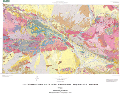
Use of this digital geologic-map database should not violate the spatial resolution of the data. Although the digital form of the data removes the constraint imposed by the scale of a paper map, the detail and accuracy inherent in map scale are also present in the digital data. Use of this digital geologic map should not violate the spatial resolution of the data. The San Bernardino 30' x 60' database was compiled from many sources including: (1) 1:62,500 reconnaisance mapping, (2) mapping from 1:24,000 USGS Open-File releases, (3) unpublished 1:24,000 mapping (4) Quaternary mapping from interpretation of 1:24,000 aerial photography, and (5) detailed 1:9,600 and 1:12,000 mapping from California Geological Survey Open-File releases. See Sheet 5, figure 3 for detailed sources of mapping. Any enlargement beyond the spatial resolution of the original geologic source data violates the spatial resolution of the data. Similarly, the digital topographic base data are derived from the U.S. Geological Survey, 1:100,000-scale San Bernardino 30' x 60' Digital Line Graphs (DLGs); any enlargement beyond this scale may be misleading. Where this database is used in combination with other data of higher resolution, the resolution of the combined output will be limited by the lower resolution data. No part of the database is intended to serve for site-specific studies.
Examination of a plot of the geologic map (Sheet 1) indicates detail in some areas that is far to fine to show well at 1:100,000 scale. This detail is purposely maintained to draw attention to areas where detailed information, compiled from large-scale maps is available. This detail may be viewed by on-screen examination of the digital map coverage or by plotting selected areas at larger scales. However, any enlargement beyond the spatial resolution of the original geologic source data violates the spatial resolution of the data.
  1. Who distributes the data set? (Distributor 1 of 1)
    U.S. Geological Survey Information Services
    Box 25286 Denver Federal Center
    Denver, CO
    USA

    303-202-4700 (voice)
    303-202-4693 (FAX)
  2. What's the catalog number I need to order this data set? USGS Open-File Report 03-293
  3. What legal disclaimers am I supposed to read?
    The U.S. Geological Survey (USGS) provides these geographic data "as is." The USGS makes no guarantee or warranty concerning the accuracy of information contained in the geographic data. The USGS further makes no warranties, either expressed or implied as to any other matter whatsoever, including, without limitation, the condition of the product, or its fitness for any particular purpose. The burden for determining fitness for use lies entirely with the user. Although these data have been processed successfully on computers at the USGS, no warranty, expressed or implied, is made by the USGS regarding the use of these data on any other system, nor does the fact of distribution constitute or imply any such warranty.
    In no event shall the USGS have any liability whatsoever for payment of any consequential, incidental, indirect, special, or tort damages of any kind, including, but not limited to, any loss of profits arising out of use of or reliance on the geographic data or arising out of the delivery, installation, operation, or support by USGS.
    This digital, geologic map database of the San Bernardino 30' x 60' quadrangle, 1:100,000 map-scale, and any derivative maps thereof, is not meant to be used or displayed at any scale larger than 1:100,000 (e.g., 1:24,000).
  4. How can I download or order the data?

Who wrote the metadata?

Dates:
Last modified: 05-Feb-2016
Last Reviewed: 26-Jul-2004
Metadata author:
Peter N Schweitzer
USGS Midwest Area
Collection manager, USGS Geoscience Data Clearinghouse, http://geo-nsdi.er.usgs.gov/
Mail Stop 954
12201 Sunrise Valley Dr
Reston, VA
USA

703-648-6533 (voice)
703-648-6252 (FAX)
pschweitzer@usgs.gov
Metadata standard:
Content Standard for Digital Geospatial Metadata (version 2.0) (FGDC-STD-001-1998)

This page is <https://geo-nsdi.er.usgs.gov/metadata/open-file/03-293/metadata.faq.html>
Generated by mp version 2.9.48 on Tue Jul 03 20:06:18 2018