A spatial database of bedding attitudes to accompany Geologic map of the greater Denver area, Front Range urban corridor, Colorado, by Donald E. Trimble and Michael N. Machette

Metadata also available as - [Outline] - [Parseable text] - [XML]

Frequently anticipated questions:


What does this data set describe?

Title:
A spatial database of bedding attitudes to accompany Geologic map of the greater Denver area, Front Range urban corridor, Colorado, by Donald E. Trimble and Michael N. Machette
Abstract:
This digital map shows bedding attitude symbols display over the geographic extent of surficial deposits and rock stratigraphic units (formations) as compiled by Trimble and Machette 1973-1977 and published in 1979 (U.S. Geological Survey Map I-856-H) under the Front Range Urban Corridor Geology Program. Trimble and Machette compiled their geologic map from published geologic maps and unpublished geologic mapping having varied map unit schemes. A convenient feature of the compiled map is its uniform classification of geologic units that mostly matches those of companion maps to the north (USGS I-855-G) and to the south (USGS I-857-F). Published as a color paper map, the Trimble and Machette map was intended for land-use planning in the Front Range Urban Corridor. This map recently (1997-1999), was digitized under the USGS Front Range Infrastructure Resources Project (see cross-reference).
In general, the mountainous areas in the west part of the map exhibit various igneous and metamorphic bedrock units of Precambrian age, major faults, and fault brecciation zones at the east margin (5-20 km wide) of the Front Range. The eastern and central parts of the map (Colorado Piedmont) depict a mantle of unconsolidated deposits of Quaternary age and interspersed outcroppings of Cretaceous or Tertiary-Cretaceous sedimentary bedrock. The Quaternary mantle is comprised of eolian deposits (quartz sand and silt), alluvium (gravel, sand, and silt of variable composition), colluvium, and few landslides. At the mountain front, north-trending, dipping Paleozoic and Mesozoic sandstone, shale, and limestone bedrock formations form hogbacks and intervening valleys.
Supplemental_Information:
Coverages included in this geospatial database:
 denvdip coverage:  bedding attitudes
 denvcnty coverage: county boundaries
 denvhwy coverage:  major highways and arterials
 denvhyp coverage:  hypsography
 denvplss coverage: township and range lines
 geoscamp2.mrk:  This markerset file defines the geologic markers in the geologically themed coverages.
  1. How might this data set be cited?
    Brandt, Theodore R., Moore, David W., and Murray, Kyle E., 2003, A spatial database of bedding attitudes to accompany Geologic map of the greater Denver area, Front Range urban corridor, Colorado, by Donald E. Trimble and Michael N. Machette: U.S. Geological Survey Open-File Report 03-25, United States Geological Survey, Denver, Colorado, U.S.A..

    Online Links:

  2. What geographic area does the data set cover?
    West_Bounding_Coordinate: -105.375
    East_Bounding_Coordinate: -104.625
    North_Bounding_Coordinate: 40.0
    South_Bounding_Coordinate: 39.375
  3. What does it look like?
    http://pubs.usgs.gov/of/2003/ofr-03-025/OFR-03-025-thb.gif (GIF)
    Reduced-size image of the entire map sheet, 300x217 pixels, 21k bytes
    http://pubs.usgs.gov/of/2003/ofr-03-025/OFR-03-025map.pdf (PDF)
    Printable representation of map layout, 10 megabytes
  4. Does the data set describe conditions during a particular time period?
    Calendar_Date: 2003
    Currentness_Reference:
    publication date
  5. What is the general form of this data set?
    Geospatial_Data_Presentation_Form: map
  6. How does the data set represent geographic features?
    1. How are geographic features stored in the data set?
      This is a Vector data set.
    2. What coordinate system is used to represent geographic features?
      Grid_Coordinate_System_Name: Universal Transverse Mercator
      Universal_Transverse_Mercator:
      UTM_Zone_Number: 13
      Transverse_Mercator:
      Scale_Factor_at_Central_Meridian: 0.9996
      Longitude_of_Central_Meridian: -105
      Latitude_of_Projection_Origin: 0.0
      False_Easting: 500000
      False_Northing: 0.0
      Planar coordinates are encoded using coordinate pair
      Abscissae (x-coordinates) are specified to the nearest 2.5
      Ordinates (y-coordinates) are specified to the nearest 2.5
      Planar coordinates are specified in METERS
      The horizontal datum used is North American Datum of 1927.
      The ellipsoid used is Clarke 1866.
      The semi-major axis of the ellipsoid used is 6378206.4.
      The flattening of the ellipsoid used is 1/294.98.
  7. How does the data set describe geographic features?
    Entity_and_Attribute_Overview:
    The data is supplied in ARC/INFO export format.
    DATABASE STRUCTURE - ARC/INFO ====================================
    This GIS database includes related look-up tables, which store detailed attribute information. This database structure is more fully described in USGS OFR 99-438. The GIS database structure used in the database includes symbol items in coverage point, polygon (PAT) and arc (AAT)attribute tables for user convenience. Arc/Info relates for each coverage are saved in a file named <covername>.rel. Use the RELATE command with the restore argument at the arc prompt to make the relates active. Alternatively, in Arctools, use the Relate environment: open dialog in the Manage - Relates flyout menu under the Arctools menu to make the relates active.
    denvdip coverage: Contains points recording site-specific observations and measurements, such as strike and dip of bedding. In the denvdip.pat INFO file the PTTYPE item lists the type of point symbol, e.g., strike and dip of inclined bedding. The SYMBOL item lists the marker symbol used by ArcInfo to identify the type of structural map symbol(Symbol numbers refer to the geoscamp2.mrk markerset). The STRIKE item contains the strike of bedding. Strike is an azimuthal angle (measured in degrees from 0 to 360 in a clockwise direction from North). The DIP item contains the dip of bedding. This value is an angle measured (in degrees 0 to 90) down from the horizontal; thus a horizontal dip is 0 degrees and a vertical dip is 90 degrees. The SOURCE item lists the numeric code used to identify the data source. The DISPLAY item is coded 1 when a point is displayed on the map layout, 2 when it is not. Some data points are not displayed on the map because they would overpost adjacent data points at the 1:100,000 display scale.
    In the coverage's denvdip.ref INFO file the SOURCE item lists the numeric code used to identify the data source. The scale item lists the scale of the source map. (This value is the denominator of the proportional fraction that identifies the scale of the map that was digitized or scanned to produce the digital map.) The AUTHORS item lists the author(s) or compiler(s) of source map entered as last name, first name or initial, and middle initial. The YEAR item lists the source (map) publication date. The REFERENCE item lists the remainder of the reference in USGS reference format.
    denvcnty coverage: Contains lines representing county boundaries derived from Colorado Department of Local Affairs, Colorado Office of Emergency Management data.
    In the coverage's denvcnty.ref INFO file the SOURCE item lists the numeric code used to identify the data source. The scale item lists the scale of the source map. (This value is the denominator of the proportional fraction that identifies the scale of the map that was digitized or scanned to produce the digital map.) The AUTHORS item lists the author(s) or compiler(s) of source map entered as last name, first name or initial, and middle initial. The YEAR item lists the source (map) publication date. The REFERENCE item lists the remainder of the reference in USGS reference format.
    denvhwy coverage: Contains lines representing highways and major arterials. In the denvhwy.aat INFO file the FEATURID item contains a unique line identifier assigned by the Federal Highway Administration. The DESCRIPT item provides the name or identification for the link (i.e. BASELINE RD). The DSOURCE item provides the original source of the coordinate information (i.e. S=State Supplied Digital Data, U=USGS Digital Line Graphs, T=US Census TIGER/Line files, M=Digitized from State supplied maps, H=Military Supplied data, all other values indicate Unknown). The STFIPS item indicates the two character State FIPS Code (FIPS Pub 6-4). The CTFIPS item indicates the three digit County FIPS code (FIPS Pub 6-4). The SIGN1 item indicates the Primary Sign Route (i.e. I-25). The SIGN2 item indicates the Alternate Sign Route. The MILES item indicates an accurate measurement in miles for the link chain. The KM item indicates an accurate measurement in kilometers for the link chain. The FACTYPE item describes the permissible flow of traffic over the link (1=One-way flow, 2=Bi-directional flow). The LANES item indicates the number of lanes in both directions.
    In the coverage's denvhwy.ref INFO file the SOURCE item lists the numeric code used to identify the data source. The scale item lists the scale of the source map. (This value is the denominator of the proportional fraction that identifies the scale of the map that was digitized or scanned to produce the digital map.) The AUTHORS item lists the author(s) or compiler(s) of source map entered as last name, first name or initial, and middle initial. The YEAR item lists the source (map) publication date. The REFERENCE item lists the remainder of the reference in USGS reference format.
    denvhyp coverage: Contains lines representing hypsographic contours derived from USGS Digital Line Graph data. In the denvhyp.aat INFO file the ELEV item contains the contour elevation in meters.
    In the coverage's denvhyp.ref INFO file the SOURCE item lists the numeric code used to identify the data source. The scale item lists the scale of the source map. (This value is the denominator of the proportional fraction that identifies the scale of the map that was digitized or scanned to produce the digital map.) The AUTHORS item lists the author(s) or compiler(s) of source map entered as last name, first name or initial, and middle initial. The YEAR item lists the source (map) publication date. The REFERENCE item lists the remainder of the reference in USGS reference format.
    denvplss coverage: Contains lines representing U.S. Public Land Survey System township and range lines derived from USGS Digital Line Graph data
    In the coverage's denvplss.ref INFO file the SOURCE item lists the numeric code used to identify the data source. The scale item lists the scale of the source map. (This value is the denominator of the proportional fraction that identifies the scale of the map that was digitized or scanned to produce the digital map.) The AUTHORS item lists the author(s) or compiler(s) of source map entered as last name, first name or initial, and middle initial. The YEAR item lists the source (map) publication date. The REFERENCE item lists the remainder of the reference in USGS reference format.
    The INFO structure of these files is listed below:
    DENVDIP.PAT:
    COLUMN   ITEM NAME        WIDTH OUTPUT  TYPE N.DEC  ALTERNATE NAME
        1  AREA                   8    18     F      5
        9  PERIMETER              8    18     F      5
       17  DENVDIP#               4     5     B      -
       21  DENVDIP-ID             4     5     B      -
       25  PTTYPE                80    80     C      -
      105  SYMBOL                 3     3     I      -
      108  STRIKE                 3     3     I      -
      111  DIP                    3     3     I      -
      114  SOURCE                 4     4     I      -
      118  DISPLAY                3     3     I      -
    
    DENVDIP.REF:
    
    COLUMN   ITEM NAME        WIDTH OUTPUT  TYPE N.DEC  ALTERNATE NAME
        1  SOURCE                 4     4     I      -
        5  SCALE                  8     8     I      -
       13  AUTHORS              200   200     C      -
      213  YEAR                   4     4     I      -
      217  REFERENCE            250   250     C      -
    
    DENVCNTY.AAT:
    
    COLUMN   ITEM NAME        WIDTH OUTPUT  TYPE N.DEC  ALTERNATE NAME
        1  FNODE#                 4     5     B      -
        5  TNODE#                 4     5     B      -
        9  LPOLY#                 4     5     B      -
       13  RPOLY#                 4     5     B      -
       17  LENGTH                 8    18     F      5
       25  DENVCNTY#              4     5     B      -
       29  DENVCNTY-ID            4     5     B      -
       33  SOURCE                 4     4     I      -
    
    DENVCNTY.REF:
    
    COLUMN   ITEM NAME        WIDTH OUTPUT  TYPE N.DEC  ALTERNATE NAME
        1  SOURCE                 4     4     I      -
        5  SCALE                  8     8     I      -
       13  AUTHORS              200   200     C      -
      213  YEAR                   4     4     I      -
      217  REFERENCE            250   250     C      -
    
    DENVHWY.AAT:
    
    COLUMN   ITEM NAME        WIDTH OUTPUT  TYPE N.DEC  ALTERNATE NAME
        1  FNODE#                 4     5     B      -
        5  TNODE#                 4     5     B      -
        9  LPOLY#                 4     5     B      -
       13  RPOLY#                 4     5     B      -
       17  LENGTH                 8    18     F      5
       25  DENVHWY#               4     5     B      -
       29  DENVHWY-ID             4     5     B      -
       33  FEATURID               8    20     F      0
       41  DESCRIPT              35    35     C      -
       76  DSOURCE                1     1     C      -
       77  STFIPS                 2     2     C      -
       79  CTFIPS                 3     3     C      -
       82  SIGN1                  6     6     C      -
       88  SIGN2                  6     6     C      -
       94  MILES                  4    13     F      2
       98  KM                     4    13     F      2
      102  FACTYPE                8    11     F      0
      110  LANES                  8    11     F      0
      118  SOURCE                 4     4     I      -
    
    DENVHWY.REF:
    
    COLUMN   ITEM NAME        WIDTH OUTPUT  TYPE N.DEC  ALTERNATE NAME
    COLUMN   ITEM NAME        WIDTH OUTPUT  TYPE N.DEC  ALTERNATE NAME
        1  SOURCE                 4     4     I      -
        5  SCALE                  8     8     I      -
       13  AUTHORS              200   200     C      -
      213  YEAR                   4     4     I      -
      217  REFERENCE            250   250     C      -
    
    DENVHYP.AAT:
    
    COLUMN   ITEM NAME        WIDTH OUTPUT  TYPE N.DEC  ALTERNATE NAME
        1  FNODE#                 4     5     B      -
        5  TNODE#                 4     5     B      -
        9  LPOLY#                 4     5     B      -
       13  RPOLY#                 4     5     B      -
       17  LENGTH                 8    18     F      5
       25  DENVHYP#               4     5     B      -
       29  DENVHYP-ID             4     5     B      -
       33  ELEV                   6     6     I      -
       39  SOURCE                 4     4     I      -
    
    DENVHYP.REF:
    
    COLUMN   ITEM NAME        WIDTH OUTPUT  TYPE N.DEC  ALTERNATE NAME
    COLUMN   ITEM NAME        WIDTH OUTPUT  TYPE N.DEC  ALTERNATE NAME
        1  SOURCE                 4     4     I      -
        5  SCALE                  8     8     I      -
       13  AUTHORS              200   200     C      -
      213  YEAR                   4     4     I      -
      217  REFERENCE            250   250     C      -
    
    DENVPLSS.AAT:
    
    COLUMN   ITEM NAME        WIDTH OUTPUT  TYPE N.DEC  ALTERNATE NAME
        1  FNODE#                 4     5     B      -
        5  TNODE#                 4     5     B      -
        9  LPOLY#                 4     5     B      -
       13  RPOLY#                 4     5     B      -
       17  LENGTH                 8    18     F      5
       25  DENVPLSS#              4     5     B      -
       29  DENVPLSS-ID            4     5     B      -
       33  SOURCE                 4     4     I      -
    
    DENVPLSS.REF:
    
    COLUMN   ITEM NAME        WIDTH OUTPUT  TYPE N.DEC  ALTERNATE NAME
        1  SOURCE                 4     4     I      -
        5  SCALE                  8     8     I      -
       13  AUTHORS              200   200     C      -
      213  YEAR                   4     4     I      -
      217  REFERENCE            250   250     C      -
    
    Coding of PTTYPE in the denvdip coverage:
    
    Horizontal bedding
    Inclined bedding - Showing strike and dip
    Overturned bedding - Showing strike and dip
    Vertical bedding - Showing strike
    
    Entity_and_Attribute_Detail_Citation: http://pubs.usgs.gov/of/2003/ofr-03-025/OFR-03-025text508.pdf

Who produced the data set?

  1. Who are the originators of the data set? (may include formal authors, digital compilers, and editors)
    • Theodore R. Brandt
    • David W. Moore
    • Kyle E. Murray
  2. Who also contributed to the data set?
  3. To whom should users address questions about the data?
    Theodore R. Brandt
    U.S. Geological Survey
    MS 980, Box 25046 DFC
    Denver, CO
    USA

    303-236-1901 (voice)
    303-236-0214 (FAX)
    tbrandt@usgs.gov

Why was the data set created?

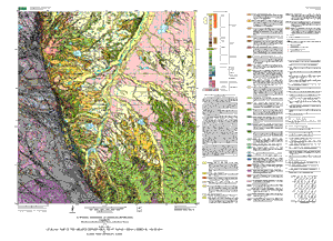
This digital map can serve various purposes related to land-use planning in the greater Denver metropolitan area. It shows potential shallow aquifers and rock units that are suitable for waste disposal, and aggregate mining, for example. The map distinguishes rock units that are somewhat predictable (dependent on scale and uniformity of the rock unit) in physical properties and mineral content, making the map useful in planning. Given this predictability, experts can use the map to derive thematic maps that show the suitability of surficial materials for various uses by man; or to derive maps that show areas susceptible to certain hazards, for example, swelling soils, heaving bedrock, landslides.
The digital map is designed to provide geologic data at 1:100,000 scale to address urban growth issues and to help resolve conflicts among planned uses of the land.

How was the data set created?

  1. From what previous works were the data drawn?
    Bryant and others (1973) (source 1 of 9)
    Bryant B. H., Miller R. D., and, and R., Scott G., 1973, Geologic map of the Indian Hills quadrangle, Jefferson County, Colorado: U.S. Geological Survey Geologic Quadrangle Map GQ-1073.

    Type_of_Source_Media: paper
    Source_Contribution: geologic data source
    Scott (1961) (source 2 of 9)
    Scott, G. R., 1961, Preliminary geologic map of the Indian Hills quadrangle, Jefferson County, Colorado: U.S. Geological Survey Miscellaneous Investigations Map I-333.

    Type_of_Source_Media: paper
    Source_Contribution: geologic data source
    Scott (1962) (source 3 of 9)
    Scott, G. R., 1962, Geology of the Littleton quadrangle, Jefferson, Douglas, and Arapahoe Counties, Colorado: U.S. Geological Survey Bulletin 1121-L.

    Other_Citation_Details: 53 p.
    Type_of_Source_Media: paper
    Source_Contribution: geologic data source
    Scott (1963) (source 4 of 9)
    Scott, G. R., 1963, Bedrock geology of the Kassler quadrangle, Colorado: U.S. Geological Survey Professional Paper PP-421-B.

    Other_Citation_Details: p. 71-125
    Type_of_Source_Media: paper
    Source_Contribution: geologic data source
    Scott (1972) (source 5 of 9)
    Scott, G. R., 1972, Geologic map of the Morrison quadrangle, Jefferson County, Colorado: U.S. Geological Survey Miscellaneous Investigations Map I-790-A.

    Type_of_Source_Media: paper
    Source_Contribution: geologic data source
    Spencer (1961) (source 6 of 9)
    Spencer, F.D., 1961, Bedrock geology of the Louisville quadrangle, Colorado: U.S. Geological Survey Geologic Quadrangle Map GQ-151.

    Type_of_Source_Media: paper
    Source_Contribution: geologic data source
    Van Horn (1957) (source 7 of 9)
    Van Horn, Richard, 1957, Bedrock geology of the Golden quadrangle, Colorado: U.S. Geological Survey Geologic Quadrangle Map GQ-103.

    Type_of_Source_Media: paper
    Source_Contribution: geologic data source
    Van Horn (1972) (source 8 of 9)
    Van Horn, Richard, 1972, Surficial and bedrock geologic map of the Golden quadrangle, Jefferson County, Colorado: U.S. Geological Survey Miscellaneous Investigations Map I-761-A.

    Type_of_Source_Media: paper
    Source_Contribution: geologic data source
    Wells (1967) (source 9 of 9)
    Wells, J. D., 1967, Geology of the Eldorado Springs quadrangle, Boulder and Jefferson Counties, Colorado: U.S. Geological Survey Bulletin 1221-D.

    Other_Citation_Details: 85 p.
    Type_of_Source_Media: paper
    Source_Contribution: geologic data source
  2. How were the data generated, processed, and modified?
    Date: 1999 (process 1 of 2)
    The geologic database was compiled using ARC/INFO. Subsequent to this original compilation, we edited and corrected the database by digitizing directly into ARC/INFO from original published maps. An average RMS error of .003 or better was achieved in digitizing these features.
    Date: 12-Sep-2003 (process 2 of 2)
    Creation of original metadata record Person who carried out this activity:
    Theodore Brandt
    U.S. Geological Survey
    U.S. Geological Survey
    Denver, CO

    303-236-1901 (voice)
  3. What similar or related data should the user be aware of?
    Trimble, Donald E., and Machette, Michael N., 1979, Geologic map of the greater Denver area, Front Range urban corridor, Colorado, by Donald E. Trimble and Michael N. Machette: U.S. Geological Survey Miscellaneous Investigations Series Map I-856-H, United States Geological Survey, Denver, Colorado.

    Online Links:


How reliable are the data; what problems remain in the data set?

  1. How well have the observations been checked?
    Geologic bedding attitude points were captured by hand digitizing. The digital map was assembled and edited in ARC/INFO by manually comparing hard copy plots of the digital data with source map data.
  2. How accurate are the geographic locations?
    Digitized positions on the map that depict bedding attitude symbols are estimated to be within about 50 m of the actual measurement point on the land in most instances. Horizontal positional accuracy is tested by visual comparison of hard copy test plots to source maps or comparing locations of data on a computer monitor to other data layers in the same geographic area. The database contains elevation and U.S. Public Land Survey System data derived from U. S. Geological Survey Digital Line Graph data. Accuracy of these digital data indirectly depends on accuracy of the base maps on which the original source geologic maps were compiled. These base maps were made by the U.S. Geological Survey, which routinely checks them for compliance with the National Map Accuracy Standards. Highway location data derived from U.S. Department of Transportation National Transportation Atlas, 2001 National Highway Planning Network Version 3.0 was compiled from various sources at a scale of 1:100,000 and has a positional accuracy of within 80 m of actual transportation feature position. County boundary data derived from Colorado Department of Local Affairs, Colorado Office of Emergency Management data was compiled at a scale of 1:50,000 and has a positional accuracy of within 50 m of actual boundary feature position.
  3. How accurate are the heights or depths?
  4. Where are the gaps in the data? What is missing?
    This report has not been reviewed for conformity with U.S. Geological Survey editorial standards and stratigraphic nomenclature. Data are complete: no features of Trimble and Machette's map (USGS Map I-856-H) compiled map were eliminated or generalized. Properties and physical characteristics of geologic map units (rock-stratigraphic and surficial units) are described in the text explanation. Digital base map coverage are included with this report.
  5. How consistent are the relationships among the observations, including topology?
    Map elements were visually checked for overshoots, undershoots, duplicate features, and other errors. The original Trimble and Machette published paper map (USGS Map I-856-H) conformed with U.S. Geological Survey editorial standards and stratigraphic nomenclature. The digital version of Map I-856-H (version 1.1) strictly follows this nomenclature and was reviewed by another geologist and cartographer for consistency with basic geologic principles and general conformity to USGS mapping standards. ARC/INFO software was used to create topological relations among features.

How can someone get a copy of the data set?

Are there legal restrictions on access or use of the data?
Access_Constraints: none
Use_Constraints:
none. Acknowledgment of the U.S. Geological Survey would be appreciated in products derived from these data. Although software enables the user to display images at various scales, map data in this report should not be used at scales greater than 1:100,000.
  1. Who distributes the data set? (Distributor 1 of 1)
    U.S. Geological Survey
    Central Publications Group
    Denver, CO

    303-236-5486 (voice)
    webmaster@geology.cr.usgs.gov
  2. What's the catalog number I need to order this data set?
  3. What legal disclaimers am I supposed to read?
    Although this digital spatial data has been subjected to rigorous review and is substantially complete, it is released on the condition that neither the USGS nor the United States Government nor any agency thereof, nor any employees thereof, make any warranty, expressed or implied, or assumes any legal liability or responsibility for the accuracy, completeness, or usefulness of any information, apparatus, product, or process disclosed in this report, or represents that its use would not infringe privately owned rights. Reference therein to any specific commercial product, process, or service by trade name, trademark, manufacturer, or otherwise does not necessarily constitute or imply its endorsement, recommendation, or favoring by the United States Government or any agency thereof. Any views and opinions of authors expressed herein do not necessarily state or reflect those of the United States Government or any agency thereof.
  4. How can I download or order the data?

Who wrote the metadata?

Dates:
Last modified: 10-Jun-2016
Metadata author:
Peter N Schweitzer
USGS Midwest Area
Collection manager, USGS Geoscience Data Clearinghouse, http://geo-nsdi.er.usgs.gov/
Mail Stop 954
12201 Sunrise Valley Dr
Reston, VA
USA

703-648-6533 (voice)
703-648-6252 (FAX)
pschweitzer@usgs.gov
Metadata standard:
Content Standard for Digital Geospatial Metadata (FGDC-STD-001-1998)

This page is <https://geo-nsdi.er.usgs.gov/metadata/open-file/03-25/metadata.faq.html>
Generated by mp version 2.9.48 on Tue Jul 03 20:06:14 2018