Digital soils survey map of the Patagonia Mountains, Arizona

Metadata also available as - [Questions & Answers] - [Parseable text] - [XML]

Metadata:

Identification_Information:
Citation:
Citation_Information:
Originator: Laura Margaret Norman
Publication_Date: 2002
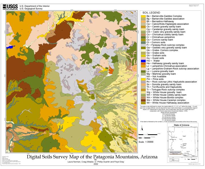
Title: Digital soils survey map of the Patagonia Mountains, Arizona
Edition: Version 1.5, March 12, 2002
Geospatial_Data_Presentation_Form: map
Series_Information:
Series_Name: U.S. Geological Survey Open File Report
Issue_Identification: 02-324
Publication_Information:
Publication_Place: Menlo Park, California
Publisher: U.S. Geological Survey
Online_Linkage: http://pubs.usgs.gov/of/2002/0324/
Description:
Abstract:
The Soil Survey of Santa Cruz and Parts of Cochise and Pima Counties, Arizona, a product of the USDA Soil Conservation Service and the Forest Service in cooperation with the Arizona Agricultural Experiment Station, released in 1979, was created according to the site conditions in 1971, when soil scientists identified soils types on aerial photographs. The scale at which these maps were published is 1:20,000.
These soil maps were automated for incorporation into the hydrologic modeling within a GIS. The aerial photos onto which the soils units were drawn had not been orthoganalized, and contained distortion. A total of 15 maps composed the study area. These maps were scanned into TIFF format using an 8-bit black and white drum scanner at 100 dpi. The images were imported into ERDAS IMAGINE and the white borders were removed through subset decollaring processes. Five CD-ROMs containing Digital Orthophoto Quarter Quads (DOQQs) were used to register and rectify the scanned soils maps. Polygonal data was then attributed according to the datasets.
Purpose:
Beginning in March of 1997, the Preliminary Assessment of the Patagonia Mountains study area was undertaken. An integrated watershed analysis using Geographic Information Systems (GIS) based platform was undertaken to examine transport characteristics. The Universal Soil Loss Equation (USLE) and the Spatially Explicit Delivery MODel (SEDMOD) were chosen to assist in characterization of potential point and nonpoint source material yield within selected drainage systems.
This was done to provide information useful for defining areas of significant environmental impact and to shed some light on the most practical remediation strategies to be employed. Many studies have been conducted to determine different parameters, effects and contributions of human activity in the Patagonia and southern Santa Rita Mountains study area. Incorporation to a digital data model required acquisition of accurate geo-spatial digital soils data. This digital geospatial database is one of many being created by the U.S. Geological Survey as an ongoing effort to provide geologic information in a geographic information system (GIS) for use in spatial analysis.
Time_Period_of_Content:
Time_Period_Information:
Single_Date/Time:
Calendar_Date: 2002
Currentness_Reference: publication date
Status:
Progress: In work
Maintenance_and_Update_Frequency: None Planned
Spatial_Domain:
Bounding_Coordinates:
West_Bounding_Coordinate: -110.85575013
East_Bounding_Coordinate: -110.61876161
North_Bounding_Coordinate: 31.55456386
South_Bounding_Coordinate: 31.33518703
Keywords:
Theme:
Theme_Keyword_Thesaurus: none
Theme_Keyword: Soils
Theme:
Theme_Keyword_Thesaurus: USGS Thesaurus
Theme_Keyword: soil resources
Theme_Keyword: maps and atlases
Theme_Keyword: geospatial datasets
Theme:
Theme_Keyword_Thesaurus: ISO 19115 Topic Categories
Theme_Keyword: geoscientificInformation
Place:
Place_Keyword_Thesaurus: none
Place_Keyword: Southeastern Arizona
Place_Keyword: Patagonia, Arizona
Place_Keyword: USA
Place_Keyword: Arizona
Place:
Place_Keyword_Thesaurus: Augmented FIPS 10-4 and FIPS 6-4
Place_Keyword: f04023 = Santa Cruz
Access_Constraints: none
Use_Constraints:
Anyone who uses these data must cite USGS. These data are not to be used at scales greater than 1:20,000.
Point_of_Contact:
Contact_Information:
Contact_Person_Primary:
Contact_Person: Laura Margaret Norman
Contact_Organization: US Geological Survey, GD
Contact_Position: Geographer, GIS Specialist
Contact_Address:
Address_Type: mailing and physical address
Address: 520 North Park Avenue, Suite 355
City: Tucson
State_or_Province: Arizona
Postal_Code: 85719
Country: USA
Contact_Voice_Telephone: (520) 670-5510
Contact_Facsimile_Telephone: (fax) (520) 670-5571
Contact_Electronic_Mail_Address: lmbrady@usgs.gov
Browse_Graphic:
Browse_Graphic_File_Name: Browse_Graphic_File_Description: Reduced-size image of the map sheet, 720x593 pixels, 92k bytes
Browse_Graphic_File_Type: JPEG
Data_Set_Credit:
Coauthors helped to generate the final product map and ArcInfo coverage. Craig Wissler, professor at the University of Arizona, oversaw the automation and attribution of the actual data, while D.P. Guertin, also a professor at the University of Arizona, helped in assessing the final product and its further applications. Floyd Gray, geologist at the USGS, hired the work to be done as part of a 5-year project investigation of the fate and transport of minerals in the Patagonia Mountains in association with abandoned mine locations. Karen Bolm, also of the USGS, helped tremendously in the review of digital and manuscript data.
Native_Data_Set_Environment:
SunOS, 5.6, sun4u UNIX ARCINFO version 7.2.1
Data_Quality_Information:
Attribute_Accuracy:
Attribute_Accuracy_Report:
The final file was converted and compressed within ARCINFO to TIFF format and laid out onscreen with known vector coverages of digitized roads and rivers overlaid to check for accuracy and error. The most useful was the road coverage downloaded the AZGENREF library, which identified error to be within +/- 40 meters. This digital database is not meant to be used or displayed at any scale larger than 1:20,000.
Logical_Consistency_Report:
Polygon topology present. All polygons are closed.
Completeness_Report:
Only the maps that covered the study area of interest were digitized.
Positional_Accuracy:
Horizontal_Positional_Accuracy:
Horizontal_Positional_Accuracy_Report: Identified error to be within +/- 40 meters
Lineage:
Source_Information:
Source_Citation:
Citation_Information:
Originator: U.S. Department of Agriculture
Publication_Date: 1979
Title:
Soil survey of Santa Cruz and parts of Cochise and Pima counties, Arizona
Geospatial_Data_Presentation_Form: Hardcopy aerial photos with polygonal soil attributes traced on
Publication_Information:
Publication_Place: Washington, D.C.
Publisher: U.S. Government Printing Office
Other_Citation_Details:
USDA Soil Conservation Service and Forest Service in cooperation with Arizona Agricultural Experiment Station
Source_Scale_Denominator: 20000
Type_of_Source_Media: paper
Source_Time_Period_of_Content:
Time_Period_Information:
Range_of_Dates/Times:
Beginning_Date: 1967
Ending_Date: 1970
Source_Currentness_Reference: ground condition
Source_Citation_Abbreviation: USDA survey
Source_Contribution: soils map
Process_Step:
Process_Description:
Known points were identified on the aerial photo and matched to points on the DOQQs, these were referred to as Ground Control Points (GCPs). This was the most time consuming portion of this project as the aerial photos were taken some 30 years prior to the DOQQs and buildings, trees, and waterways had changed considerably. The easiest and most accurate objects to identify were roads and intersections of roads with other features. These appeared to have the same shape throughout time, although some forest roads are out of use, or have been paved or widened. A 3rd order polynomial transformation requires a minimum of 10 GCPs to be identified. However, the level of accuracy increases as more points are entered and widely distributed. The GCP prediction tool within ERDAS IMAGINE uses the current transformation parameters to guess where the user will locate GCPs from the work in progress to source data, this enables the user to determine when enough points have been entered to ensure that the transformation is accurate. An average of 80 GCPs were identified on each aerial photo and cross-referenced with the source data for this study. The cubic convolution method of resampling was performed to effectively pierce the aerial photo with pinpoints to known real time coordinates and stretch or fold the picture to accurate proportions. This sampling method is suggested for aerial photos in which the cell size is dramatically changed. This transformed the image of an abstract piece of paper into an accurate representation of real time and space with registered known coordinates. The cubic convolution method resamples using an algorithm which recognizes the data files of 16 pixels in a 4 by 4 window, and this creates the most accurate output when ortho-rectifying aerial photos. Error still exists despite the high number of GCPs used to control the transformation. It is difficult to accurately fit images over mountainous terrain from aerial photos. Error existed in the DOQQs and new error was introduced in the resampling process. However, the photos edge-matched positively and roads, rivers, trees and soil polygons merged together seamlessly when mosaiced to create the big picture. The raster geometric correction was successful for use in this project.
Process_Date: 2000
Process_Step:
Process_Description:
Fifth draft of metadata created by lmbrady using FGDCMETA.AML ver. 1.2 05/14/98 on ARC/INFO data set /bdr2/lmbrady/scs_soil
Process_Date: 20020312
Process_Step:
Process_Description: Creation of original metadata record
Process_Date: 20020312
Process_Contact:
Contact_Information:
Contact_Organization_Primary:
Contact_Organization: USGS
Contact_Person: Laura Margaret Norman
Contact_Position: Geographer/ GIS Specialist
Contact_Address:
Address_Type: mailing and physical address
Address: 520 North Park Avenue Suite #355
City: Tucson
State_or_Province: AZ
Postal_Code: 85719
Country: USA
Contact_Voice_Telephone: (520) 670-5510
Contact_Facsimile_Telephone: (fax)(520) 670-5571
Contact_Electronic_Mail_Address: lmbrady@usgs.gov
Spatial_Data_Organization_Information:
Direct_Spatial_Reference_Method: Vector
Point_and_Vector_Object_Information:
SDTS_Terms_Description:
SDTS_Point_and_Vector_Object_Type: Point
Point_and_Vector_Object_Count: 360
SDTS_Terms_Description:
SDTS_Point_and_Vector_Object_Type: String
Point_and_Vector_Object_Count: 1015
SDTS_Terms_Description:
SDTS_Point_and_Vector_Object_Type: GT-polygon composed of chains
Point_and_Vector_Object_Count: 361
Spatial_Reference_Information:
Horizontal_Coordinate_System_Definition:
Planar:
Grid_Coordinate_System:
Grid_Coordinate_System_Name: Universal Transverse Mercator
Universal_Transverse_Mercator:
UTM_Zone_Number: 12
Transverse_Mercator:
Scale_Factor_at_Central_Meridian: 0.9996
Longitude_of_Central_Meridian: -111
Latitude_of_Projection_Origin: 0.0
False_Easting: 500000
False_Northing: 0.0
Planar_Coordinate_Information:
Planar_Coordinate_Encoding_Method: coordinate pair
Coordinate_Representation:
Abscissa_Resolution: 2.5
Ordinate_Resolution: 2.5
Planar_Distance_Units: Meters
Geodetic_Model:
Horizontal_Datum_Name: North American Datum of 1983
Ellipsoid_Name: GRS1980
Semi-major_Axis: 6378206.4
Denominator_of_Flattening_Ratio: 294.98
Entity_and_Attribute_Information:
Overview_Description:
Entity_and_Attribute_Overview:
Explanations of the user defined items listed below can be found in OFR text:
SCS_SOIL83.PAT:

COLUMN   ITEM NAME        WIDTH OUTPUT  TYPE N.DEC  ALT. NAME
1 	AREA                   8    18     F      5
9  	PERIMETER              8    18     F      5
17  	SCS_SOIL83#            4     5     B      -
21  	SCS_SOIL83-ID          4     5     B      -
25  	SOIL_SERIES            2     2     C      -
27  	SLOPE                  2     2     C      -
29  	IFERODED               2     2     I      -

SCS_SOIL83.AAT:

COLUMN   ITEM NAME        WIDTH OUTPUT  TYPE N.DEC  ALT. NAME
1  	FNODE#                 4     5     B      -
5  	TNODE#                 4     5     B      -
9  	LPOLY#                 4     5     B      -
13  	RPOLY#                 4     5     B      -
17  	LENGTH                 8    18     F      5
25  	SCS_SOIL83#            4     5     B      -
29  	SCS_SOIL83-ID          4     5     B      -
Entity_and_Attribute_Detail_Citation: http://pubs.usgs.gov/of/2002/0324/pdf/scs_soil.pdf
Detailed_Description:
Entity_Type:
Entity_Type_Label: scs_soil.dbf
Entity_Type_Definition: soil unit
Attribute:
Attribute_Label: SOIL_SERIES
Attribute_Definition: Soil series designation (2-letter abbreviation)
Attribute_Domain_Values:
Enumerated_Domain:
Enumerated_Domain_Value: Ba
Enumerated_Domain_Value_Definition:
Barkerville-Gaddes Complex -- Gravelly sandy loam and sandy clay loam
Attribute_Domain_Values:
Enumerated_Domain:
Enumerated_Domain_Value: Bg
Enumerated_Domain_Value_Definition:
Barkerville-Gaddes Association -- Gravelly sandy loam and sandy clay loam
Attribute_Domain_Values:
Enumerated_Domain:
Enumerated_Domain_Value: Bh
Enumerated_Domain_Value_Definition:
Bernadino-Hathaway Association -- Gravelly clay loam and cobbly sandy loam
Attribute_Domain_Values:
Enumerated_Domain:
Enumerated_Domain_Value: Ca
Enumerated_Domain_Value_Definition:
Calciorthids-Haplargids Association -- Properties too variable to be estimated
Attribute_Domain_Values:
Enumerated_Domain:
Enumerated_Domain_Value: Cb
Enumerated_Domain_Value_Definition:
Canelo Gravelly Sandy Loam -- Gravelly, very gravelly, or cobbly sandy loam
Attribute_Domain_Values:
Enumerated_Domain:
Enumerated_Domain_Value: Cg
Enumerated_Domain_Value_Definition:
Caralampi Gravelly Sandy Loam -- Gravelly sandy loam and very gravelly sandy clay loam
Attribute_Domain_Values:
Enumerated_Domain:
Enumerated_Domain_Value: Cm
Enumerated_Domain_Value_Definition:
Casto Very Gravelly Sandy Loam -- Gravelly and very gravelly sandy clay loam
Attribute_Domain_Values:
Enumerated_Domain:
Enumerated_Domain_Value: Co
Enumerated_Domain_Value_Definition:
Chiricahua Cobbly Sandy Loam -- Cobbly or gravelly heavy clay loam or clay
Attribute_Domain_Values:
Enumerated_Domain:
Enumerated_Domain_Value: Cr
Enumerated_Domain_Value_Definition:
Chiricahua- Lampshire Association -- Cobbly or gravelly heavy clay loam or clay
Attribute_Domain_Values:
Enumerated_Domain:
Enumerated_Domain_Value: Cs
Enumerated_Domain_Value_Definition: Comoro Sandy Loam -- Sandy loam and gravelly sandy loam
Attribute_Domain_Values:
Enumerated_Domain:
Enumerated_Domain_Value: Ct
Enumerated_Domain_Value_Definition: Comoro Soils -- Sandy loam and gravelly sandy loam
Attribute_Domain_Values:
Enumerated_Domain:
Enumerated_Domain_Value: Fr
Enumerated_Domain_Value_Definition: Faraway- Rock Outcrop Complex -- Very cobbly fine sandy loam
Attribute_Domain_Values:
Enumerated_Domain:
Enumerated_Domain_Value: Ga
Enumerated_Domain_Value_Definition:
Gaddes Very Gravelly Sandy Loam -- Gravelly sandy loam, sandy loam, sandy clay loam, gravelly clay, and cobbly sandy clay loam
Attribute_Domain_Values:
Enumerated_Domain:
Enumerated_Domain_Value: Gb
Enumerated_Domain_Value_Definition: Grabe- Comoro Complex -- Loam and sandy loam
Attribute_Domain_Values:
Enumerated_Domain:
Enumerated_Domain_Value: Ge
Enumerated_Domain_Value_Definition: Grabe Soils -- Loam and sandy loam
Attribute_Domain_Values:
Enumerated_Domain:
Enumerated_Domain_Value: Gh
Enumerated_Domain_Value_Definition: Graham Soils -- Very cobbly clay loam and clay
Attribute_Domain_Values:
Enumerated_Domain:
Enumerated_Domain_Value: Gu
Enumerated_Domain_Value_Definition: Guest Soils -- Clay, gravelly clay and gravelly clay loam
Attribute_Domain_Values:
Enumerated_Domain:
Enumerated_Domain_Value: HO
Enumerated_Domain_Value_Definition: Water Bodies
Attribute_Domain_Values:
Enumerated_Domain:
Enumerated_Domain_Value: Ha
Enumerated_Domain_Value_Definition:
Hathaway Gravelly Sandy Loam -- Gravelly sandy clay loam, gravelly and very gravelly sandy loam, and sandy loam
Attribute_Domain_Values:
Enumerated_Domain:
Enumerated_Domain_Value: Lc
Enumerated_Domain_Value_Definition: Lampshire-Chiricahua Association -- Very cobbly loam
Attribute_Domain_Values:
Enumerated_Domain:
Enumerated_Domain_Value: Lg
Enumerated_Domain_Value_Definition: Lampshire- Graham- Rock Outcrop Association -- Very cobbly loam
Attribute_Domain_Values:
Enumerated_Domain:
Enumerated_Domain_Value: Lu
Enumerated_Domain_Value_Definition:
Luzena Gravelly Loam, Deep Variant -- Gravelly clay loam and gravelly clay
Attribute_Domain_Values:
Enumerated_Domain:
Enumerated_Domain_Value: Mg
Enumerated_Domain_Value_Definition: Martinez Gravelly Loam -- Loam or clay loam and clay
Attribute_Domain_Values:
Enumerated_Domain:
Enumerated_Domain_Value: NA
Enumerated_Domain_Value_Definition: Not Available Undefined soil type
Attribute_Domain_Values:
Enumerated_Domain:
Enumerated_Domain_Value: Pm
Enumerated_Domain_Value_Definition: Pima Soils -- Clay loam
Attribute_Domain_Values:
Enumerated_Domain:
Enumerated_Domain_Value: Rn
Enumerated_Domain_Value_Definition:
Rock Outcrop- Lithic Haplustolls Association Properties too variable to be estimated
Attribute_Domain_Values:
Enumerated_Domain:
Enumerated_Domain_Value: So
Enumerated_Domain_Value_Definition: Sonoita Gravelly Sandy Loam -- Gravelly sandy loam
Attribute_Domain_Values:
Enumerated_Domain:
Enumerated_Domain_Value: Th
Enumerated_Domain_Value_Definition:
Torrifluvents and Haplustoils -- Properties too variable to be estimated
Attribute_Domain_Values:
Enumerated_Domain:
Enumerated_Domain_Value: Tr
Enumerated_Domain_Value_Definition: Tortugas- Rock Outcrop Complex -- Very cobbly loam
Attribute_Domain_Values:
Enumerated_Domain:
Enumerated_Domain_Value: Wg
Enumerated_Domain_Value_Definition: White House Gravelly Loam -- Gravelly loam, clay loam, and clay
Attribute_Domain_Values:
Enumerated_Domain:
Enumerated_Domain_Value: Wh
Enumerated_Domain_Value_Definition:
White House Cobbly Sandy Loam -- Gravelly loam, clay loam, and clay
Attribute_Domain_Values:
Enumerated_Domain:
Enumerated_Domain_Value: Wn
Enumerated_Domain_Value_Definition:
White House- Bonita Complex -- Gravelly loam, clay loam, and clay
Attribute_Domain_Values:
Enumerated_Domain:
Enumerated_Domain_Value: Wo
Enumerated_Domain_Value_Definition:
White House- Caralampi Complex -- Gravelly loam, clay loam, and clay
Attribute_Domain_Values:
Enumerated_Domain:
Enumerated_Domain_Value: Wt
Enumerated_Domain_Value_Definition:
White House- Hathaway Association -- Gravelly loam, clay loam, and clay
Attribute:
Attribute_Label: SLOPE
Attribute_Definition: Categorized slope steepness (2-letter abbreviation)
Attribute_Domain_Values:
Enumerated_Domain:
Enumerated_Domain_Value: B
Enumerated_Domain_Value_Definition: 0-5 percent slopes
Attribute_Domain_Values:
Enumerated_Domain:
Enumerated_Domain_Value: C
Enumerated_Domain_Value_Definition: 1-10 percent slopes
Attribute_Domain_Values:
Enumerated_Domain:
Enumerated_Domain_Value: D
Enumerated_Domain_Value_Definition: 0-20 percent slopes
Attribute_Domain_Values:
Enumerated_Domain:
Enumerated_Domain_Value: E
Enumerated_Domain_Value_Definition: 20-40 percent slopes
Attribute_Domain_Values:
Enumerated_Domain:
Enumerated_Domain_Value: F
Enumerated_Domain_Value_Definition: 1 -- 60 percent slopes
Attribute:
Attribute_Label: IFERODED
Attribute_Definition: Code indicating eroded slopes (integer)
Attribute_Domain_Values:
Enumerated_Domain:
Enumerated_Domain_Value: 0
Enumerated_Domain_Value_Definition: not considered eroded at the time of the survey
Attribute_Domain_Values:
Enumerated_Domain:
Enumerated_Domain_Value: 2
Enumerated_Domain_Value_Definition: eroded at the time of the survey
Distribution_Information:
Distributor:
Contact_Information:
Contact_Organization_Primary:
Contact_Organization: USGS Information Services
Contact_Address:
Address_Type: mailing address
Address: Box 25286 Denver Federal Center
City: Denver
State_or_Province: CO
Postal_Code: 80225
Country: USA
Contact_Voice_Telephone: 1-888-ASK-USGS
Contact_Facsimile_Telephone: 303-202-4693
Contact_Electronic_Mail_Address: ask@usgs.gov
Distribution_Liability:
The U.S. Geological Survey (USGS) provides these geographic data "as is." The USGS makes no guarantee or warranty concerning the accuracy of information contained in the geographic data. The USGS further makes no warranties, either expressed or implied, as to any other matter whatsoever, including, but without limitation to, the condition of the product of its fitness for any particular purpose. The burden for determining fitness for use lies entirely with the user. Although these data have been processed successfully on computers with USGS, no warranty, expressed or implied, is made by the USGS regarding the use of these data on any other system, nor does the fact of distribution constitute or imply such warranty.
In no event shall the USGS have any liability whatsoever for payment of any consequential, incidental, indirect, special, or tort damages of any kind, including, but not limited to, any loss of profits arising out of use of or reliance on the geographical data or arising out of the delivery, installation operation, or support by USGS.
The digital geologic map GIS of the Patagonia Mountains area in Arizona is not meant to be used or displayed at any scale larger than 1:20,000 (for example, 1:12,000).
Standard_Order_Process:
Digital_Form:
Digital_Transfer_Information:
Format_Name: ARCE
Format_Version_Number: 7.2.1
Format_Information_Content: Soil units
File_Decompression_Technique: none
Transfer_Size: 3.5
Digital_Transfer_Option:
Online_Option:
Computer_Contact_Information:
Network_Address:
Fees: none
Metadata_Reference_Information:
Metadata_Date: 20160610
Metadata_Contact:
Contact_Information:
Contact_Person_Primary:
Contact_Person: Peter N Schweitzer
Contact_Organization: USGS Midwest Area
Contact_Position:
Collection manager, USGS Geoscience Data Clearinghouse, http://geo-nsdi.er.usgs.gov/
Contact_Address:
Address_Type: mailing address
Address:
Mail Stop 954
12201 Sunrise Valley Dr
City: Reston
State_or_Province: VA
Postal_Code: 20192-0002
Country: USA
Contact_Voice_Telephone: 703-648-6533
Contact_Facsimile_Telephone: 703-648-6252
Contact_Electronic_Mail_Address: pschweitzer@usgs.gov
Metadata_Standard_Name: Content Standard for Digital Geospatial Metadata
Metadata_Standard_Version: FGDC-STD-001-1998
Metadata_Access_Constraints: none
Metadata_Use_Constraints: none

This page is <https://geo-nsdi.er.usgs.gov/metadata/open-file/02-324/metadata.html>
Generated by mp version 2.9.48 on Tue Jul 03 20:06:08 2018