Geologic Map of the Riverside West 7.5' Quadrangle, Riverside County, California

Metadata also available as - [Outline] - [Parseable text] - [XML]

Frequently anticipated questions:


What does this data set describe?

Title:
Geologic Map of the Riverside West 7.5' Quadrangle, Riverside County, California
Abstract:
This data set maps and describes the geology of the Riverside West 7.5' quadrangle, Riverside County, California. Created using Environmental Systems Research Institute's ARC/INFO software, the data base consists of the following items: (1) a map coverage containing geologic contacts and units, (2) a coverage containing structural data, (3) a coverage containing geologic unit annotation and leaders, and (4) attribute tables for geologic units (polygons), contacts (arcs), and site-specific data (points). In addition, the data set includes the following graphic and text products: (1) a postscript graphic plot-file containing the geologic map, topography, cultural data, a Correlation of Map Units (CMU) diagram, a Description of Map Units (DMU), and a key for point and line symbols, and (2) PDF files of the Readme (including the metadata file as an appendix), and the graphic produced by the Postscript plot file.
The Riverside West quadrangle is located in the northern part of the Perris block, a relatively stable, rectangular-in-plan area located between the Elsinore and San Jacinto fault zones in the northern Peninsular Ranges Province.
Most of the quadrangle is covered by a variable thickness of Quaternary alluvial material deposited on Cretaceous and older basement rocks. In the southern part of the quadrangle, northwest trending amphibolite grade biotite-bearing schist of Mesozoic or older age separates massive textured granitic rocks to the west from foliated and layered granitic rocks to the east. In the northern part of the quadrangle, scattered exposures of amphibolite grade biotite schist, impure quartzite, marble, calc-silicate rock, and skarn are probably Paleozoic. In the northeast corner of the quadrangle probable Paleozoic marble, which was quarried for local use, is intruded by tonalite, producing pyroxene-hornfels grade garnet-pyroxene skarn.
The wide variety of mafic to silicic Cretaceous plutonic rocks in the quadrangle, are part of the composite Peninsular Ranges batholith. Hornblende and pyroxene gabbro, oldest of the plutonic rocks, occurs as a number of scattered small bodies. The relatively large gabbro body located at the south edge of the quadrangle extends for some distance south into the Lake Mathews quadrangle. On both sides of this body, the granodiorite of the Cajalco pluton contains numerous stoped masses of gabbro. Most of the granitic rock in the quadrangle is tonalitic with a faint to pronounced planar fabric produced by oriented biotite and hornblende. This planar structure in the northern two-thirds of the quadrangle typically strikes east, distinct from the northwest strike of planar structures common to most of the Peninsular Ranges batholith. The northwest part of the extensive, relatively uniform medium-to coarse-grained biotite-hornblende tonalite the Val Verde pluton underlies the southeast corner of the quadrangle. Relatively mafic hornblende and biotite-hornblende quartz diorite occurs in the central part of the quadrangle, and heterogeneous tonalite underlies most of the Pedley Hills in the north part of the quadrangle. In the southwestern part of the quadrangle, the northeastern extent of the lesser amounts of biotite-hornblende granodiorite. Common to this part of the Cajalco pluton are concentrated large and small stoped blocks of gabbro, most too small to be mapped at 1:24,000-scale. Numerous, massive to foliated, leucocratic biotite granite bodies are scattered thoughout the quadrangle. At Mount Rubidoux, very distinctive, dark colored, massive, coarse-grained granite contains hypersthene and fayalitic olivine in addition to biotite and hornblende.
Located along the southwest boundary of the quadrangle is a very small occurrence of Paleocene? conglomerate that consists of exotic welded-tuff clasts and a few exotic bedded quartzite clasts. Several small areas of late Pliocene or early Pleistocene, slightly indurated fluvial sand, gravel, and cobbles occur in the Arlington area. Clasts in the deposits north of State Highway 91 consist entirely of San Bernardino Mountains lithologies. The deposits south of State Highway 91 consist of an upper section composed of slightly indurated bouldery gravel and sand derived from nearby Peninsular Ranges basement rocks and a lower section composed of clasts of San Bernardino Mountains lithologies. The patches of sediments containing San Bernardino Mountains lithologies are interpreted as being erosional remanants of paleo-Santa Ana River deposits, deposited when the river course was further south than its present day course.
Most of the lower elevation areas of the quadrangle are covered by Pleistocene alluvial fan deposits. These fans were graded to the location of the present day course of the Santa Ana River but at a slightly higher elevation than the elevation of the present day river grade.
The eastern part of the Santa Ana River includes a relatively broad young fluvial expanse and the western part is a relatively narrow alluvial channel incised into bedrock.
The geologic map data base contains original U.S. Geological Survey data generated by detailed field observation recorded on 1:24,000 scale aerial photographs. The map was created by transferring lines from the aerial photographs to a 1:24,000 scale topographic base. The map was digitized and lines, points, and polygons were subsequently edited using standard ARC/INFO commands. Digitizing and editing artifacts significant enough to display at a scale of 1:24,000 were corrected. Within the database, geologic contacts are represented as lines (arcs), geologic units are polygons, and site-specific data as points. Polygon, arc, and point attribute tables (.pat, .aat, and .pat, respectively) uniquely identify each geologic datum.
  1. How might this data set be cited?
    Morton, Douglas M., and Cox, Brett F., 2001, Geologic Map of the Riverside West 7.5' Quadrangle, Riverside County, California: U.S. Geological Survey Open-File Report 01-451, U.S. Geological Survey, Menlo Park, California.

    Online Links:

  2. What geographic area does the data set cover?
    West_Bounding_Coordinate: -117.5000914
    East_Bounding_Coordinate: -117.3749086
    North_Bounding_Coordinate: 34.00000046
    South_Bounding_Coordinate: 33.87498306
  3. What does it look like?
    http://pubs.usgs.gov/of/2001/0451/images/rsw.jpg (JPEG)
    Reduced-size image of the map, 400x548 pixels, 32-bit RGB true color 95 kbytes.
    http://pubs.usgs.gov/of/2001/0451/pdf/rsw_map.pdf (PDF)
    Printable map sheet, 1.6 megabytes
  4. Does the data set describe conditions during a particular time period?
    Calendar_Date: 2001
    Currentness_Reference:
    New data obtained
  5. What is the general form of this data set?
    Geospatial_Data_Presentation_Form: vector digital data
  6. How does the data set represent geographic features?
    1. How are geographic features stored in the data set?
      This is a Vector data set. It contains the following vector data types (SDTS terminology):
      • Point (209)
      • String (531)
      • GT-polygon composed of chains (210)
    2. What coordinate system is used to represent geographic features?
      The map projection used is Polyconic.
      Projection parameters:
      Latitude_of_Projection_Origin: 33.875
      Longitude_of_Central_Meridian: -117.4375
      False_Easting: 0.00000
      False_Northing: 0.00000
      Planar coordinates are encoded using coordinate pair
      Abscissae (x-coordinates) are specified to the nearest 1.000380039215
      Ordinates (y-coordinates) are specified to the nearest 1.000380039215
      Planar coordinates are specified in Meters
      The horizontal datum used is North American Datum of 1927.
      The ellipsoid used is Clarke 1866.
      The semi-major axis of the ellipsoid used is 6378206.4.
      The flattening of the ellipsoid used is 1/294.98.
  7. How does the data set describe geographic features?
    Entity_and_Attribute_Overview:
    Version 1.0 of the Riverside West 7.5' quadrangle comprises three ARC/INFO coverages, of which two contain geologic data, and one contains cartographic features: rsw_geo (geology), rsw_str (structural data), and rsw_ano (annotation and leaders).
    Geologic data represented by line entities and the polygons they delineate are contained in the coverage RSW_GEO. For display purposes, the annotation coverage contains one annotation subclass: anno.geo contains unit labels.
    Geological point data includes site-specific information describing the types and the orientation of bedding, foliation, and lineations. Annotation is respective dip and plunge values associated with individual point data.
    RSW_GEO.PAT:
    
    COLUMN   ITEM NAME        WIDTH OUTPUT  TYPE N.DEC  ALTERNATE NAME
        1  AREA                   4    12     F      3
        5  PERIMETER              4    12     F      3
        9  RSW_GEO#               4     5     B      -
       13  RSW_GEO-ID             4     5     B      -
       17  LABL                  35    35     C      -
       52  SHD                    3     3     I      -
       55  PLABL                 35    35     C      -
       90  SHDFIL                 3     3     I      -
       93  NAME                 200   200     C      -
    
    RSW_GEO.AAT:
    
    COLUMN   ITEM NAME        WIDTH OUTPUT  TYPE N.DEC  ALTERNATE NAME
        1  FNODE#                 4     5     B      -
        5  TNODE#                 4     5     B      -
        9  LPOLY#                 4     5     B      -
       13  RPOLY#                 4     5     B      -
       17  LENGTH                 4    12     F      3
       21  RSW_GEO#               4     5     B      -
       25  RSW_GEO-ID             4     5     B      -
       29  LTYPE                 35    35     C      -
       64  L-SYMB                 3     3     I      -
    
    Entity_and_Attribute_Detail_Citation: http://pubs.usgs.gov/of/2001/0451/pdf/README.pdf
    rsw_geo.pat
    Geologic units (LABL) and their corresponding names (NAME) identified in the Riverside West 7.5' quadrangle
    LABL
    geologic map unit label, in plain text
    ValueDefinition
    KcgMonzogranite of Cajalco pluton
    KcgbGranodiorite and gabbro, undifferentiated of Cajalco pluton
    KdqdDiorite and quartz diorite, undifferentiated
    KgGranitic dikes
    KgbGabbro
    KguGranite, undifferentiated
    KlstLa Sierra tonalite
    KmrgGranite of Mount Rubidoux
    KqdQuartz diorite, undifferentiated
    KrgGranite of the Riverside area
    KtTonalite, undifferentiated
    KtdTonalite dikes of Mount Rubidoux
    KvtVal Verde tonalite
    Kvt?Val Verde tonalite
    MzsSchist
    PzmsMarble and schist, undifferentiated
    PzqImpure quartzite
    PzsBiotite schist
    QTcConglomerate sedimentary rocks of Riverside West 7.5' quadrangle
    QTsUnnamed late Cenozoic sedimentary rocks in Riverside and Corona areas
    QafArtificial fill
    QofaOld alluvial fan deposits, arenaceous
    QovaOld alluvial valley deposits, arenaceous
    QvofaVery old alluvial fan deposits, arenaceous
    QwaWash deposits, arenaceous
    QyaaYoung axial channel deposits, arenaceous
    QyeYoung eolian deposits
    QyfaYoung alluvial fan deposits, arenaceous
    QywaYoung wash deposits, arenaceous
    TcgaConglomerate at Arlington Mountain
    PLABL
    Geological map unit label used to generate plot labels with relevant stratigraphic symbols. The geologic units with LABL designating Mesozoic (Mz) have keystroke substitute characters, }, that call their corresponding symbols from the Stratagem Font Group. Geologic map unit labels will plot on derivative map plots with appropriate stratigraphic symbols if PLABL is used as the source for unit labels.
    SHD
    polygon color (as integer value) from shadeset alc1.shd (included in the data package)
    SHDFIL
    polygon fill pattern (as integer value) from shadeset geology2.shd (included in the data package)
    NAME
    Geologic name of map unit (see list under LABL attribute)
    rsw_geo.aat
    Geologic features such as contacts and faults that bound rock-unit polygons
    LTYPE
    Description of types of lines on the geologic map (contact, fault).
    ValueDefinition
    map boundary 
    contact, certain 
    L-SYMB
    stores appropriate line symbol value from the lineset geoscamp2.lin
    rsw_str.pat
    Geological point data includes site-specific information describing the types and the orientation of bedding, foliation, and lineations. One annotation subclass is included in the geologic points coverage, STP_STR which displays the respective dip and plunge values associated with individual point data.
    PTTYPE
    describes type of point data (bedding, horizontal bedding, foliation)
    P-SYMB
    Coded integer value that relates point to cartographic point symbol in markerset geoscamp2.mrk
    STRIKE
    Azimuthal strike of planar feature
    DIP
    Dip of planar feature
    rsw_ano.aat
    Annotation leaders
    L-SYMB
    Coded integer value (1) that relates arcs to cartographic line symbol in lineset geoscamp2.lin

Who produced the data set?

  1. Who are the originators of the data set? (may include formal authors, digital compilers, and editors)
    • Douglas M. Morton
    • Brett F. Cox
  2. Who also contributed to the data set?
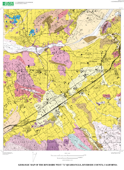
    Geologic mapping and digital preparation of this report were sponsored jointly by (1) the National Cooperative Geologic Mapping Program of the U.S. Geological Survey, (2) the California Division of Mines and Geology, and (3) the Southern California Areal Mapping Project (SCAMP).
  3. To whom should users address questions about the data?
    Douglas M Morton
    U.S. Geological Survey, GEO-WRG-NGM
    UC - Riverside
    Riverside, CA
    USA

    909-276-6397 (voice)
    909-276-6295 (FAX)
    scamp@usgs.gov

Why was the data set created?

The data set for the Riverside West 7.5' quadrangle was prepared under the U.S. Geological Survey Southern California Areal Mapping Project (SCAMP) as part of an ongoing effort to develop a regional geologic framework of southern California, and to utilize a Geographic Information System (GIS) format to create regional digital geologic databases. These regional databases are being developed as contributions to the National Geologic Map Database of the National Cooperative Geologic Mapping Program of the USGS.

How was the data set created?

  1. From what previous works were the data drawn?
  2. How were the data generated, processed, and modified?
    Date: 1978 (process 1 of 6)
    Field mapping and aerial photograph interpretation; iterative process (D.M. Morton).
    Date: 1980 (process 2 of 6)
    Field mapping and aerial photograph interpretation; iterative process (B.F. Cox).
    Date: 1999 (process 3 of 6)
    Digitization of geologic linework and point data from a scale-stable cartographic base of quadrangle. ARC/INFO database established; cleanup of artifacts; polygon, arc, and point attribute tables established. Digitizing and editing artifacts significant enough to display at a scale of 1:24,000 were corrected (R.M. Alvarez and V.M. Diep).
    Date: 2001 (process 4 of 6)
    Description of map units and correlation of map units (F.K. Miller).
    Date: 02-Oct-2001 (process 5 of 6)
    First draft of metadata created by Michael J. Watson using FGDCMETA.AML ver. 1.2 05/14/98 on ARC/INFO data set /scamp26/mwatson/rsw_ofr/rsw_geo
    Date: 02-Oct-2001 (process 6 of 6)
    Creation of original metadata record Person who carried out this activity:
    U.S. Geological Survey
    Attn: Rachel M.H. Alvarez
    Geologist
    U.S. Geological Survey
    Department of Earth Sciences
    University of California, Riverside
    Riverside, California
    USA

    (909) 276-6397 (voice)
    (909) 276-6295 (FAX)
    rhauser@usgs.gov
  3. What similar or related data should the user be aware of?
    Morton, D.M., 1999, Preliminary digital geologic map of the Santa Ana 30'x60' quadrangle, southern California, version 1.0.: U.S. Geological Survey Open-File Report 99-172, U.S. Geological Survey, California.

    Online Links:


How reliable are the data; what problems remain in the data set?

  1. How well have the observations been checked?
    Geologic-map units in the Riverside West quadrangle database were described using standard field methods. Consistent with these methods, the database author has assigned standard geologic attributes to geologic lines, points, and polygons identified in the database.
    Nationwide geologic-map accuracy standards have not been developed and adopted by the U.S. Geological Survey and other earth-science entities. Until such standards are adopted, the SCAMP project has developed internal map-accuracy standards for 1:24,000-scale geologic maps produced by the project.
    Geologic lines and points on 1:24,000 scale geologic maps are judged to meet SCAMP's internal map-accuracy standards if they are located to within +/-15 meters, relative to topographic or cultural features on the base map.
    On any derivative geologic-map plot, line data that are judged to meet the SCAMP internal map-accuracy standard are denoted by solid lines; line data that may not meet the SCAMP internal map-accuracy standard are denoted by dashed or dotted lines. There is no cartographic device for denoting the map-accuracy for geologic-point data (e.g., symbols representing bedding, foliation, lineations, etc.).
  2. How accurate are the geographic locations?
    The maximum transformation RMS error acceptable for a 7.5' quadrangle transformation and data input is 0.003 (1.8 meters). Horizontal positional accuracy was checked by visual comparison of hard-copy plots with base-stable source data.
  3. How accurate are the heights or depths?
  4. Where are the gaps in the data? What is missing?
    The geologic map database of the Riverside West 7.5' quadrangle contains new data that have been subjected to rigorous review and are a substantially complete representation of the current state of knowledge concerning the geology of the quadrangle.
  5. How consistent are the relationships among the observations, including topology?
    Polygon and chain-node topology present.
    The areal extent of the map is represented digitally by an appropriately projected (polyconic projection), mathematically generated box. Consequently, polygons intersecting the lines that comprise the map boundary are closed by that boundary. Polygons internal to the map boundary are completely enclosed by line segments which are themselves a set of sequentially numbered coordinate pairs. Point data are represented by coordinate pairs.

How can someone get a copy of the data set?

Are there legal restrictions on access or use of the data?
Access_Constraints: None
Use_Constraints:
The Riverside West 7.5' geologic-map database should be used to evaluate and understand the geologic character of the Riverside West 7.5' quadrangle as a whole. The data should not be used for purposes of site-specific land-use planning or site-specific geologic evaluations. The database is sufficiently detailed to identify and characterize many actual and potential geologic hazards represented by faults and landslides and posed by ground subsidence and earthquake-generated ground shaking. However, it is not sufficiently detailed for site-specific determinations or evaluations of these features. Faults shown do not take the place of fault-rupture hazard zones designated by the California State Geologist (see Hart, 1988).
Use of this digital geologic-map database should not violate the spatial resolution of the data. Although the digital form of the data removes the constraint imposed by the scale of a paper map, the detail and accuracy inherent in map scale are also present in the digital data. The fact that this database was compiled and edited at a scale of 1:24,000 means that higher resolution information may not have been uniformly retained in the dataset. Plotting at scales larger than 1:24,000 will not yield greater real detail, although it may reveal fine-scale irregularities below the intended resolution of the database. Similarly, although higher resolution data is incorporated in most of the map, the resolution of the combined output will be limited by the lower resolution data.
  1. Who distributes the data set? (Distributor 1 of 1)
    U.S. Geological Survey Information Services
    Box 25286 Denver Federal Center
    Denver, Colorado
    USA

    (303)202-4700 (voice)
    (303)202-4693 (FAX)
  2. What's the catalog number I need to order this data set? USGS Open-File Report 01-451
  3. What legal disclaimers am I supposed to read?
    The U.S. Geological Survey (USGS) provides these geographic data "as is." The USGS makes no guarantee or warranty concerning the accuracy of information contained in the geographic data. The USGS further makes no warranties, either expressed or implied as to any other matter whatsoever, including, without limitation, the condition of the product, or its fitness for use lies entirely with the user. Although these data have been processed successfully on computers at the USGS, no warranty, expressed or implied, is made by the USGS regarding the use of these data on any other system, nor does the fact of distribution constitute or imply any such warranty.
    In no event shall the USGS have any liability whatsoever for payment of any consequential, incidental, indirect, special, or tort damages of any kind, including, but not limited to, any loss of profits arising out of use of or reliance on the geographic data or arising out of the delivery, installation, operation, or support by USGS.
    This digital geologic map database of the Riverside West 7.5' quadrangle, 1:24,000 map-scale, and any derivative maps thereof, is not meant to be used or displayed at any scale larger than 1:24,000 (e.g., 1:12,000).
  4. How can I download or order the data?
    • Availability in digital form:
      Data format: Geologic units and structural features, with TIFF image of base map in format ARCE (version 7.2.1) Size: 1.8
      Network links: http://pubs.usgs.gov/of/2001/0451/rsw.tar.gz
    • Cost to order the data: none


Who wrote the metadata?

Dates:
Last modified: 10-Jun-2016
Metadata author:
Peter N Schweitzer
USGS Midwest Area
Collection manager, USGS Geoscience Data Clearinghouse, http://geo-nsdi.er.usgs.gov/
Mail Stop 954
12201 Sunrise Valley Dr
Reston, VA
USA

703-648-6533 (voice)
703-648-6252 (FAX)
pschweitzer@usgs.gov
Metadata standard:
Content Standard for Digital Geospatial Metadata (FGDC-STD-001-1998)

This page is <https://geo-nsdi.er.usgs.gov/metadata/open-file/01-451/metadata.faq.html>
Generated by mp version 2.9.48 on Tue Jul 03 20:06:01 2018