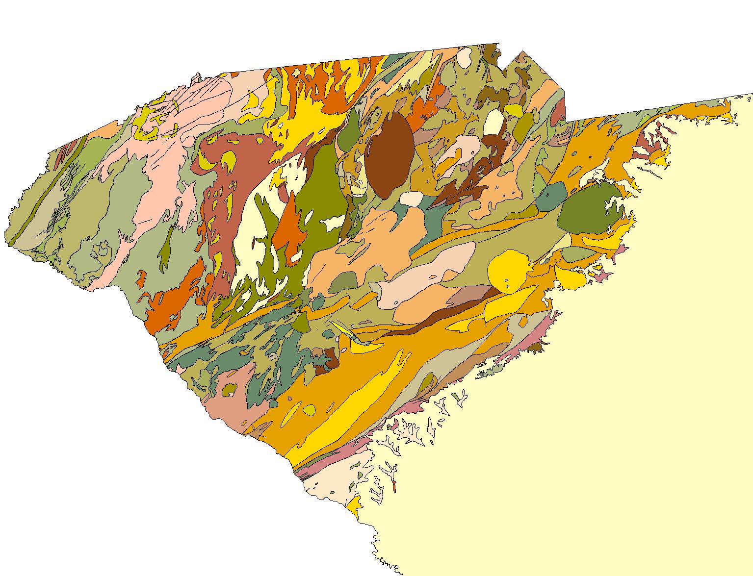
Online Links:
| Value | Definition |
|---|---|
| TK | Coastal Plain sediments (Tertiary and Cretaceous)? |
| TRc | Chatham Group (Triassic)? |
| bz | Mylonitic rocks of Brevard fault zone (Late Paleozoic)? |
| myg | mylonitic gneiss (Late Paleozoic)? |
| ph | Phyllonite and phyllonitic schist (Late Paleozoic)? |
| mym | Mylonitic rocks of Modoc fault zone (Late Paleozoic)? |
| Cg | Granite (Carboniferous and Permian)? |
| Cd | Gabbro and diorite (Carboniferous)? |
| DScg | (Concord Plutonic Suite) Gabbro? |
| DScs | (Concord Plutonic Suite) Syenite? |
| Dgg | (Concord Plutonic Suite) Gray Court metagranite (Devonian)? |
| Dp | (Concord Plutonic Suite) Pacolet granite (Devonian)? |
| Dle | (Granite of Lowrys pluton) Equigranular granite (Devonian) |
| Dlp | (Granite of Lowrys pluton) Porphyritic granite (Devonian)? |
| Sgn | (Granite of Lowrys pluton) Newberry granite and similar, possibly related granites (Silurian)? |
| DSg | (Table Rock Plutonic Suite) Granodiorite gneiss and granite gneiss (Devonian to Silurian) |
| Pzgf | (Table Rock Plutonic Suite) Reedy River complex (informal name of Wagener, 1977) and smaller unnamed plutons (Paleozoic)? |
| Pzgp | (Table Rock Plutonic Suite) Gneissic granite of Greenville (Paleozoic)? |
| SOsga | (Table Rock Plutonic Suite) Gneissic granite of Antreville (Silurian to Ordovician)? |
| SOsg | (Table Rock Plutonic Suite) Gneissic granite of Starr (Silurian to Ordovician)? |
| SOg | (Table Rock Plutonic Suite) Caesars Head Granite (Silurian to Ordovician)? |
| SOgg | (Table Rock Plutonic Suite) Granite gneiss, undivided (Silurian to Ordovician)? |
| Ogt | (Table Rock Plutonic Suite) Toluca Granite and associated metagranites (Ordovician?)? |
| Omg | (Table Rock Plutonic Suite) Migmatitic granitoid gneiss (Ordovician?)? |
| Chg | Henderson Gneiss (Cambrian)? |
| Pza | Anderson metagabbro (Paleozoic?)? |
| Pzgj | Granite sheets near Joanna (Paleozoic?)? |
| Pzgsa | Santuck granite (Paleozoic?)? |
| PzZgr | Metamorphosed granitoids (Paleozoic to Neoproterozoic)? |
| CZgr | Metamorphosed granite to granodiorite (Cambrian to Neoproterozoic)? |
| CZdi | Diorite (Cambrian to Neoproterozoic)? |
| OCgw | Waxhaw metagranite (Cambrian)? |
| CZge | Edgemoor metagranite (Cambrian or Neoproterozoic)? |
| CZggf | Great Falls metagranite (Cambrian or Neoproterozoic)? |
| CZgph | Pleasant Hill metagranite (Cambrian or Neoproterozoic?)? |
| Zglt | Longtown Metagranite (Neoproterozoic)? |
| mtg | Biotite metatonalite and granodiorite (Paleozoic or Neoproterozoic?) |
| Ztr | Metatrondhjemite (Neoproterozoic?) |
| Zto | Metatonalite (Neoproterozoic)? |
| Ztl | Little Mountain metatonalite (Neoproterozoic)? |
| PzZq | Metamorphosed quartz diorite to diorite (Paleozoic or Neoproterozoic?) |
| CZmd | Metadiorite (Cambrian or Neoproterozoic?) |
| PzZg | Metagabbro and minor metadiorite (Middle Paleozoic to Neoproterozoic?)? |
| CZdg | Metadiorite and minor metagabbro, containing sparse hornblendite and pyroxenite (Cambrian or Neoproterozoic?)? |
| um | Ultramafic rock (Paleozoic or Neoproterozoic)? |
| m | Latimer complex of Griffin (1979) (Paleozoic or Neoproterozoic)? |
| hgg | (Hammett Grove Meta-igneous Suite of Mittwede (1989)) Metagabbro |
| hgu | (Hammett Grove Meta-igneous Suite of Mittwede (1989)) Metamorphosed ultramafic rocks? |
| CZbu | Ultramafic rocks of Burks Mountain complex (Cambrian or Neoproterozoic) |
| CZba | Amphibolite of Burks Mountain complex (Cambrian or Neoproterozoic) |
| CZvs | Metavolcanic and metasedimentary rocks of Belair belt (Ordovician to Neoproterozoic?)? |
| CZk | Migmatitic paragneiss and schist of Kiokee belt (Cambrian or Neoproterozoic?)? |
| OCc | Cid Formation (Ordovician to Late Cambrian?)? |
| OCr | Richtex Formation (Ordovician to Middle Cambrian)? |
| Cap | Asbill Pond Formation (Middle Cambrian)? |
| OZfs | Flat Swamp Formation (Ordovician to Neoproterozoic?)? |
| OZvi | Layered metavolcanic rocks (Ordovician to Neoproterozoic?)? |
| OZvf | Felsic metavolcanic rocks and layered felsic gneiss interpreted to be metavolcanic (Ordovician to Neoproterozoic?) |
| OZvm | Mafic to intermediate metavolcanic rocks including layered hornblende gneiss and amphibolite (Ordovician to Neoproterozoic?)? |
| CZpf | Persimmon Fork Formation (Cambrian to Neoproterozoic)? |
| CZph | Quartz-sericite phyllite and schist (Cambrian to Neoproterozoic?)? |
| Zlm | Lincolnton Metadacite (Neoproterozoic)? |
| gn | Biotite-quartz-plagioclase gneiss (Paleozoic to Neoproterozoic)? |
| am | Amphibolite and amphibole gneiss (Paleozoic to Neoproterozoic) |
| ms | Tuffaceous metasiltstone (Paleozoic to Neoproterozoic) |
| CZlr | Metasedimentary rocks of Little River Sequence (Cambrian or Neoproterozoic?)? |
| CZbl | Blacksburg Formation, undivided (Neoproterozoic?)? |
| Zba | (Battleground Formation) Metasedimentary rocks (undivided)? |
| Zbp | (Battleground Formation) Schistose to phyllitic volcaniclastic rocks |
| Zbf | (Battleground Formation) Felsic metavolcanic rocks |
| Zbm | (Battleground Formation) Mafic to intermediate metavolcanic rocks |
| eca | Enoree mélange (informal name of Mittwede and Maybin, 1989), Cedar Shoals gneiss (informal name of Horkowitz, 1984) and Cross Anchor mafic complex (informal name as used by Maybin and Niewendorp, 1993) collectively interpreted by Maybin and Niewendorp (1993) as part of Central Piedmont allochthon. Cedar Shoals gneiss is biotite-quartz-feldspar gneiss interpreted as metagraywacke and interlayered felsic gneiss interpreted as metavolcanic rock (Dennis and others, 1995, Stop 10) |
| pcc | Philson Crossroads complex (informal name of Maybin and Niewendorp, 1993)? |
| CZgi | Biotite gneiss having interlayered marble, calc-silicate gneiss, sillimanite-muscovite schist, and garnet-quartz rock (Cambrian to Neoproterozoic?)? |
| CZcp | Chauga River Formation and Poor Mountain Formation (Cambrian or Neoproterozoic?)? |
| CZwa | Wallhalla metamorphic suite (informal name of Horton and McConnell, 1991) (Cambrian or Neoproterozoic?)? |
| CZgl | Biotite-quartz-plagioclase gneiss and interlayers locally containing hornblende, sillimanite, microcline, and muscovite (Cambrian or Neoproterozoic?)? |
| CZwr | Biotite-quartz-feldspar gneiss of Whitmire reentrant (Cambrian or Neoproterozoic?)? |
| CZga | Amphibolite having interlayered biotite gneiss, hornblende gneiss, and minor mica schist (Cambrian or Neoproterozoic?) |
| CZsp | Sillimanite schist and sillimanite-mica schist (Cambrian or Neoproterozoic?)? |
| CZsg | Biotite-plagioclase-quartz gneiss and biotite-muscovite schist (Cambrian or Neoproterozoic?)? |
| CZpg | Megacrystic biotite gneiss (Cambrian or Neoproterozoic?)? |
| CZms | Sillimanite-mica schist and muscovite-biotite schist (Cambrian or Neoproterozoic?)? |
| CZbg | Biotite gneiss and muscovite-biotite gneiss (Cambrian or Neoproterozoic?)? |
| CZgs | Garnetiferous mica schist (Cambrian or Neoproterozoic?)? |
| Zatb | (Tallulah Falls Formation) Gneissic metagraywacke and schist? |
| Zata | (Tallulah Falls Formation) Amphibolite |
| Yt | Toxaway Gneiss (Mesoproterozoic)? |
| Value | Definition |
|---|---|
| Cambrian | |
| Cambrian and/or Neoproterozoic | |
| Cambrian or Neoproterozoic | |
| Cambrian to Neoproterozoic | |
| Carboniferous | |
| Carboniferous to Permian | |
| Devonian | |
| Devonian to Silurian | |
| Early Paleozoic-Neoproterozoic | |
| Late Paleozoic | |
| Mesoproterozoic | |
| Middle Cambrian | |
| Middle Paleozoic to Neoproterozoic | |
| Neoproterozoic | |
| Ordovician | |
| Ordovician to Cambrian | |
| Ordovician to Late Cambrian | |
| Ordovician to Middle Cambrian | |
| Ordovician to Neoproterozoic | |
| Ordovician to Silurian | |
| Paleozoic | |
| Paleozoic or Neoproterozoic | |
| Paleozoic to Neoproterozoic | |
| Silurian | |
| Silurian to Ordovician | |
| Tertiary and Cretaceous | |
| Triassic | |
| undetermined |
| Value | Definition |
|---|---|
| Atlantic Coastal Plain | |
| Battleground and Blacksburg Formations | |
| Bel Air Belt, layered and stratified rocks | |
| Blue Ridge | |
| Carolina Slate Belt and Charlotte Belt, layered and stratified rocks | |
| Central Piedmont Allochthon of Maybin and Niewendorp | |
| Early Mesozoic Rift Basins, layered and stratified rocks | |
| Early Paleozoic Plutonic Rocks | |
| Early Paleozoic-Neoproterozoic Plutons and Subvolcanic Complexes | |
| Kiokee Belt, layered and stratified rocks | |
| Late Paleozoic Plutonic Rocks | |
| Late Paleozoic Shear Zones | |
| Little River Belt, layered and stratified rocks | |
| Mafic-Ultramafic Complexes and Ultramafic Rocks | |
| Middle Paleozoic Plutonic Rocks | |
| Plutons of Undetermined Affinity and Age | |
| Western Piedmont, layered and stratified rocks |
| Value | Definition |
|---|---|
| Atlantic Coastal Plain | |
| Piedmont Mesozoic basin | |
| Eastern Piedmont | |
| Central Piedmont | |
| Western Piedmont | |
| Blue Ridge |
| Value | Definition |
|---|---|
| amphibolite | |
| augen gneiss | |
| biotite gneiss | |
| conglomerate | |
| diorite | |
| felsic metavolcanic rock | |
| gabbro | |
| gneiss | |
| granite | |
| granitic gneiss | |
| granitoid | |
| mafic gneiss | |
| mafic metavolcanic rock | |
| mafic rock | |
| metasedimentary rock | |
| metavolcanic rock | |
| mica schist | |
| mylonite | |
| paragneiss | |
| phyllite | |
| phyllonite | |
| quartz diorite | |
| schist | |
| syenite | |
| tonalite | |
| trondhjemite | |
| ultramafic intrusive rock | |
| unconsolidated deposit |
| Value | Definition |
|---|---|
| Ductile shear zone (Late Paleozoic) | |
| Fault (unspecified) | |
| Normal fault (Mesozoic) | |
| Thrust fault (Paleozoic) |
FAULTS.AAT:

COLUMN   ITEM NAME        WIDTH OUTPUT  TYPE N.DEC  ALTERNATE NAME
    1  FNODE#                 4     5     B      -
    5  TNODE#                 4     5     B      -
    9  LPOLY#                 4     5     B      -
   13  RPOLY#                 4     5     B      -
   17  LENGTH                 8    18     F      5
   25  FAULTS#                4     5     B      -
   29  FAULTS-ID              4     5     B      -
   33  CLASS                 40    40     C      -
GEOLOGY.PAT:

COLUMN   ITEM NAME        WIDTH OUTPUT  TYPE N.DEC  ALTERNATE NAME
    1  AREA                   8    18     F      5
    9  PERIMETER              8    18     F      5
   17  GEOLOGY#               4     5     B      -
   21  GEOLOGY-ID             4     5     B      -
   25  ID                    16    16     I      -
   41  MAP_CODE              16    16     C      -
   57  GENERAL_SY            16    16     C      -
   73  MAP_UNIT             125   125     C      -
  198  AGE                   40    40     C      -
  238  GROUPINGS             80    80     C      -
  318  DESCRIPTIO           200   200     C      -
  518  GEO_PROV              25    25     C      -
  543  LITHOLOGY             33    33     C      -
J. Wright Horton, Jr.
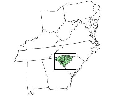
This preliminary geology coverage of the Piedmont and Blue Ridge in South Carolina is part of a set of coverages being assembled for the analysis of regional and national geochemical patterns that may have environmental and resource implications.
316000 (figure 3-3, Whitmire reentrant, scale approximate)
178570 (figure 3-4 Shoals Jct., Cokesbury, and Waterloo 7.5' quadrangles)
24000 (plates 1-3 same quadrangles)
Lambert Conic Conformal

Spheroid               Clarke 1886
Central Meridian      -96 00 00
Reference Latitude     00 00 00
Standard Parallel 1    33 00 00
Standard Parallel 2    45 00 00
Data sources used in this process:
Are there legal restrictions on access or use of the data?Access_Constraints: none
Use_Constraints:The U.S. Geological Survey makes no warranties related to the accuracy of the data and users are required to determine the suitability of use for any particular purpose.
This map should not be used at a scale greater than 1: 500,000.
The US Geological Survey provides these geographic data "as is." The USGS makes no guarantee or warranty concerning the accuracy of information contained in this geographic data. The USGS further makes no warranties, either expressed or implied as to any other matter whatsoever, including, without limitation, the condition of the product, or its fitness for any particular purpose. The burden for determining fitness for use lies entirely with the user. Although these data have been processed successfully on USGS computers, no warranty, expressed or implied, is made by the USGS regarding the use of these data on any other system, nor does the fact of distribution constitute or imply any such warranty. In no event shall the USGS have any liability whatsoever for payment of any consequential, incidental, indirect, special, or tort damages of any kind, including, but not limited to, any loss of profits arising out of use of or reliance on the geographic data or arising out of the delivery, installation, operation, or support by the USGS.
| Data format: | Geologic units, with lithology, and abbreviated base map layers in format Shapefile (version 1.0) Size: 3.1 |
|---|---|
| Network links: |
http://pubs.usgs.gov/of/2001/of01-298/data_files.zip |
| Data format: | Geologic units, with lithology, and abbreviated base map layers in format ARCE (version 8.0.1) Size: 1.8 |
|---|---|
| Network links: |
http://pubs.usgs.gov/of/2001/of01-298/export_files.zip |