Shaded-relief and Color Shaded-relief maps of the Willamette Valley, Oregon

Metadata also available as - [Outline] - [Parseable text] - [XML]

Frequently anticipated questions:


What does this data set describe?

Title:
Shaded-relief and Color Shaded-relief maps of the Willamette Valley, Oregon
Abstract:
This digital dataset was compiled from newly released U.S. Geological Survey 10-meter digital elevation model (DEM) data, along with stream and transportation coverages previously published on the internet. This report consists of a digital representation of the physiography of the Willamette Valley. Contained in this dataset is: 1) 10-meter DEM data for the entire Willamette Valley; 2) the ARC/INFO grids used to create the color shaded-relief and gray scale shaded-relief images; 3) the necessary data ARC/INFO data to used to plot these data; and 4) several reports detailing the data formats (this docuement) and producers used to create these datasets. The scale of the original 10-meter DEM data should not be violated. Any use of these original data smaller than the intended scale (1:24,000) will not yield improved accuracy.
Supplemental_Information:
The databases in this report were compiled in ARC/INFO, a commercial Geographic Information System (Environmental Systems Research Institute, Redlands, California, with version 3.0 of the menu interface ALACARTE (Fitzgibbon and Wentworth, 1991, Fitzgibbon, 1991, Wentworth and Fitzgibbon, 1991). The files are in either GRID (ARC/INFO raster data) format or COVERAGE (ARC/ INFO vector data) format. Coverages are stored in uncompressed ARC export format (ARC/INFO version 8.0.2). ARC/INFO export files (files with the .e00 extension) can be converted into ARC/ INFO coverages in ARC/INFO (see below) and can be read by some other Geographic Information Systems, such as MapInfo via ArcLink and ESRI's ArcView (version 1.0 for Windows 3.1 to 3.11 is available for free from ESRI's web site: http://www.esri.com). The digital compilation was done in version 8.0.2 of ARC/INFO with version 3.0 of the menu interface ALACARTE (Fitzgibbon and Wentworth, 1991, Fitzgibbon, 1991, Wentworth and Fitzgibbon, 1991). Custom AMLs were written to compile the 10-meter DEM data from 7.5-minute quadrangles into large composite datasets. The data was compiled as ARC/INFO grids and then converted to decimeter integer grids. This procedure greatly reduces the file sizes without downgrading the data quality. Stream coverages were merged with the grids used to create the color shaded-relief gridcomposite. Further details on the techniques used to generate these maps are available in the readme file of this report.
  1. How might this data set be cited?
    Givler, R.W., and Wells, R.E., 2001, Shaded-relief and Color Shaded-relief maps of the Willamette Valley, Oregon: U.S. Geological Survey Open-File Report 01-294, U.S. Geological Survey, Menlo Park, CA.

    Online Links:

  2. What geographic area does the data set cover?
    West_Bounding_Coordinate: -123.30
    East_Bounding_Coordinate: -122.125
    North_Bounding_Coordinate: 45.75
    South_Bounding_Coordinate: 43.50
  3. What does it look like?
    http://pubs.usgs.gov/of/2001/0294/images/will1.gif (GIF)
    Reduced-size image of the map sheet, 363x847 pixels, 32-bit RGB true color image, 129k bytes.
    http://pubs.usgs.gov/of/2001/0294/pdf/wvc250.pdf (PDF)
    A PDF representation of the color shaded-relief map at a scale of 1:250,000 (26.5 Mb).
  4. Does the data set describe conditions during a particular time period?
    Calendar_Date: 2001
    Currentness_Reference:
    publication date
  5. What is the general form of this data set?
    Geospatial_Data_Presentation_Form: vector and raster digital data
  6. How does the data set represent geographic features?
    1. How are geographic features stored in the data set?
      This is a Vector data set. It contains the following vector data types (SDTS terminology):
      • Complete chain (611)
      • Entity point (252)
      • GT-polygon composed of chains (252)
      • Point (16)
    2. What coordinate system is used to represent geographic features?
      The map projection used is Transverse Mercator.
      Projection parameters:
      Scale_Factor_at_Central_Meridian: 0.9996
      Longitude_of_Central_Meridian: -123
      Latitude_of_Projection_Origin: 0.0
      False_Easting: 500000
      False_Northing: 0.0
      Planar coordinates are encoded using coordinate pair
      Abscissae (x-coordinates) are specified to the nearest 0.000512
      Ordinates (y-coordinates) are specified to the nearest 0.000512
      Planar coordinates are specified in meters
      The horizontal datum used is North American Datum of 1927.
      The ellipsoid used is Clarke 1866.
      The semi-major axis of the ellipsoid used is 6378206.4.
      The flattening of the ellipsoid used is 1/294.98.
  7. How does the data set describe geographic features?
    Entity_and_Attribute_Overview:
    Because these data were created in Arc/Info, polygons are described by tables fitting the pattern cover.pat (here and after, "cover" refers to the name of the Arc/Info coverage). These contain the general attributes AREA, PERIMETER, cover#, and cover-ID. Likewise, lines are described by tables named cover.aat, and contain topological as well as general attributes FNODE#, TNODE#, LPOLY#, RPOLY#, LENGTH, cover#, and cover-ID.
    Because these data were created using Alacarte, the feature attribute tables also include the attributes LTYPE for lines and PTYPE for points and polygons, as well as SEL, which is used internally by Alacarte to mark features that are selected, and SYMB, which is used internally by Alacarte to symbolize the features for display. Additional attributes that contain scientific information may also be present, and are described in detail here.
    Entity_and_Attribute_Detail_Citation: http://pubs.usgs.gov/of/2001/0294/pdf/readme.pdf
    will_clip.pat
    polygons
    PTYPE
    unit labels
    ValueDefinition
    Yesmarks polygons inside map boundary
    Nomarks polygons inside map boundary
    will_clip1.pat
    polygons
    PTYPE
    unit labels
    ValueDefinition
    Yesmarks polygons inside map boundary
    Nomarks polygons inside map boundary
    will_clip.aat
    LTYPE
    Map boundaries
    ValueDefinition
    Map boundary 
    outside boundary 
    will_clip1.aat
    LTYPE
    Map boundaries
    ValueDefinition
    Map boundary 
    outside boundary 

Who produced the data set?

  1. Who are the originators of the data set? (may include formal authors, digital compilers, and editors)
    • R.W. Givler
    • R.E. Wells
  2. Who also contributed to the data set?
  3. To whom should users address questions about the data?
    U.S. Geological Survey
    Attn: Database Coordinator
    345 Middlefield Rd. MS-975
    Menlo Park, CA
    USA

    650-329-4935 (voice)
    kwheeler@usgs.gov

Why was the data set created?

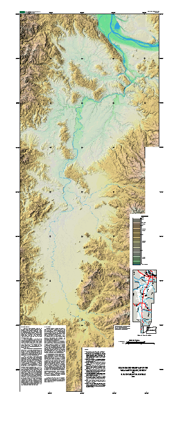
This digital data set, compiled from new 10-meter digital elevation model (DEM) data, represents the physiography of the Willamette Valley, Oregon. This new physiographic data is useful because the improved resolution allows for better visualization of flood and fluvial features in the low lying areas of the Willamette Valley. Many scientist are interested in the Willamette Valley because it is subject to a variety of earthquake hazards, and its water and geologic resources are under pressure from rapid urbanization (see sheets for a brief description). Further, this Open-File report details the techniques used to create these maps (See readme.pdf). It is the author's purpose to publish these techniques and data so others may use this report to generate their own gray scale and/or color shaded-relief maps. All information about the data and methods used to create this report are in the readme.pdf file and this document.

How was the data set created?

  1. From what previous works were the data drawn?
    streamnet.org (2001) (source 1 of 2)
    www.streamnet.org, 200108, Compiled River Reach Stream coverages at 1:100,000 from USGS DLG coverages of Oregon..

    Online Links:

    Type_of_Source_Media: digital
    Source_Scale_Denominator: 100,000
    Source_Contribution: stream linework
    2MILRD (source 2 of 2)
    U.S. Geological Survey, 1995, 1:2,000,000-scale Digital Line Graph Data - Roads: U.S. Geological Survey, Reston, VA.

    Type_of_Source_Media: on-line data
    Source_Scale_Denominator: 2000000
    Source_Contribution: spatial and attribute information
  2. How were the data generated, processed, and modified?
    Date: 2000 (process 1 of 2)
    The databases in this report were compiled in ARC/INFO, a commercial Geographic Information System (Environmental Systems Research Institute, Redlands, California, with version 3.0 of the menu interface ALACARTE (Fitzgibbon and Wentworth, 1991, Fitzgibbon, 1991, Wentworth and Fitzgibbon, 1991). The files are in either GRID (ARC/INFO raster data) format or COVERAGE (ARC/ INFO vector data) format. Coverages are stored in uncompressed ARC export format (ARC/INFO version 8.0.2). ARC/INFO export files (files with the .e00 extension) can be converted into ARC/ INFO coverages in ARC/INFO (see below) and can be read by some other Geographic Information Systems, such as MapInfo via ArcLink and ESRI's ArcView (version 1.0 for Windows 3.1 to 3.11 is available for free from ESRI's web site: http://www.esri.com). The digital compilation was done in version 8.0.2 of ARC/INFO with version 3.0 of the menu interface ALACARTE (Fitzgibbon and Wentworth, 1991, Fitzgibbon, 1991, Wentworth and Fitzgibbon, 1991).
    Date: 23-Aug-2001 (process 2 of 2)
    Creation of original metadata record Person who carried out this activity:
    Karen L. Wheeler
    U.S. Geological Survey
    Geologist/GIS
    U.S. Geological Survey
    Western Earth Surface Processes Team
    345 Middlefield Road, Mail Stop 975
    Menlo Park, CA
    USA

    650-329-4935 (voice)
    650-329-4936 (FAX)
    kwheeler@usgs.gov
  3. What similar or related data should the user be aware of?

How reliable are the data; what problems remain in the data set?

  1. How well have the observations been checked?
  2. How accurate are the geographic locations?
  3. How accurate are the heights or depths?
  4. Where are the gaps in the data? What is missing?
  5. How consistent are the relationships among the observations, including topology?

How can someone get a copy of the data set?

Are there legal restrictions on access or use of the data?
Access_Constraints: none
Use_Constraints:
Uses of this digital map should not violate the spatial resolution of the data. Although the digital form of the data removes the constraint imposed by the scale of a paper map, the detail and accuracy inherent in map scale are also present in the digital data. The fact that this database was edited for a scale of 1:24, 000 means that higher resolution information is not present in the dataset. Plotting at scales larger than 1:24,000 will not yield greater real detail, although it may reveal fine-scale irregularities below the intended resolution of the database. Similarly, where this database is used in combination with other data of higher resolution, the resolution of the combined output will be limited by the lower resolution of these data.
  1. Who distributes the data set? (Distributor 1 of 1)
    USGS Western Publications Group
    345 Middlefield Road, Mail Stop 951
    Menlo Park, CA
    US

    650-329-5057 (voice)
  2. What's the catalog number I need to order this data set? USGS Open-File Report 01-294
  3. What legal disclaimers am I supposed to read?
    This report is preliminary and has not been reviewed for conformity with U.S. Geological Survey editorial standards or with the North American Stratigraphic Code. Any use of trade, firm, or product names is for descriptive purposes only and does not imply endorsement by the U.S. Government.
  4. How can I download or order the data?

Who wrote the metadata?

Dates:
Last modified: 10-Jun-2016
Metadata author:
Peter N Schweitzer
USGS Midwest Area
Collection manager, USGS Geoscience Data Clearinghouse, http://geo-nsdi.er.usgs.gov/
Mail Stop 954
12201 Sunrise Valley Dr
Reston, VA
USA

703-648-6533 (voice)
703-648-6252 (FAX)
pschweitzer@usgs.gov
Metadata standard:
Content Standard for Digital Geospatial Metadata (FGDC-STD-001-1998)

This page is <https://geo-nsdi.er.usgs.gov/metadata/open-file/01-294/metadata.faq.html>
Generated by mp version 2.9.48 on Tue Jul 03 20:05:39 2018