Online Links:
| Value | Definition |
|---|---|
| KJe | Espada Formation of Dibblee, 1950 and 1966 |
| KJf | Franciscan Complex |
| Km | Mudstone and subordinate sandstone |
| Ks | Sandstone and subordinate mudstone |
| Ksm | Mudstone and subordinate sandstone |
| Kss | Sandstone and subordinate mudstone and conglomerate |
| Ku | Sandstone, mudstone, and subordinate conglomerate |
| QTprf | Paso Robles(?) Formation |
| Qls | Landslide deposits |
| Qoa | Old alluvium |
| Qoa1 | Old alluvium |
| Qoa2 | Old alluvium |
| Qoa3 | Old alluvium |
| Qoa4 | Old alluvium |
| Qoa5 | Old alluvium |
| Qoa6 | Old alluvium |
| Qya | Young alluvium |
| TKs | Mudstone and subordinate sandstone |
| Tca | Careaga Sandstone |
| Th | Hurricane Deck Formation of Thomas and others (1988) |
| Ti | Unnamed intrusive and extrusive rocks |
| Tm | Monterey Formation |
| Tmc | Unnamed mudstone |
| Ts | Simmler(?) Formation |
| Tsi | Unnamed sandstone intrusive into the Monterey Formation |
| Tss | Unnamed sandstone |
| Tv | Vaqueros(?) Formation |
| sp | Serpentinite |
| Value | Definition |
|---|---|
| contact, approx. located | Boundary between two mapped units that retains the original depositional or intrusive relationship (i.e. not faulted). The contact has not been observed, so it is not well-located as described in Positional_Accuracy, but the location is constrained to be within about 2 mm at map scale (1:24,000) or within about 48 meters on the ground. |
| contact, certain | Boundary between two mapped units that retains the original depositional or intrusive relationship (i.e. not faulted). The contact has been observed or is closely constrained, so it is well-located as described in Positional_Accuracy. |
| contact, inferred | Boundary between two mapped units that retains the original depositional or intrusive relationship (i.e. not faulted). The contact has not been observed, so it is not well-located as described in Positional_Accuracy, but the location is constrained to be within about 5 mm at map scale (1:24,000) or within about 120 meters on the ground. The existence of the contact is inferred from structural and stratigraphic relationships observed elsewhere. |
| fault, approx. located | Structural boundary between mapped units or structural discontinuity within a mapped unit that has experienced relative offset between the rock bodies on either side of the fault. The fault has not been observed, so it is not well-located as described in Positional_Accuracy, but the location is constrained to be within about 2 mm at map scale (1:24,000) or within about 48 meters on the ground. |
| fault, certain | Structural boundary between mapped units or structural discontinuity within a mapped unit that has experienced relative offset between the rock bodies on either side of the fault. The fault has been observed or is closely constrained, so it is well-located as described in Positional_Accuracy. |
| fault, concealed | Structural boundary between mapped units or structural discontinuity within a mapped unit that has experienced relative offset between the rock bodies on either side of the fault. The fault is obscured by overlying mapped units, so it is not well-located as described in Positional_Accuracy, but the location is constrained to be within about 5 mm at map scale (1:24,000) or within about 120 meters on the ground. |
| fault, inferred | Structural boundary between mapped units or structural discontinuity within a mapped unit that has experienced relative offset between the rock bodies on either side of the fault. The fault has not been observed, so it is not well-located as described in Positional_Accuracy, but the location is constrained to be within about 5 mm at map scale (1:24,000) or within about 120 meters on the ground. The existence of the fault is inferred from structural and stratigraphic relationships observed elsewhere. |
| map boundary | Edge of the mapped area. Used primarily to bound polygons at the edge of the map database. The location of the boundary is well located as described in Positional_Accuracy. |
| Value | Definition |
|---|---|
| apparent dip of beds | Originally horizontal sedimentary layers were observed at this point. The true strike and dip of the layers could not be ascertained. The angle between the layers and the horizontal was measured by a geologist standing at an observation point that may or may not have been located along the strike of bedding. |
| bedding estimated from afar | Originally horizontal sedimentary layers were observed at this point. The strike and dip of these layers were measured by a geologist standing more than about 12 m from this point. |
| bedding estimated from airphoto | Originally horizontal sedimentary layers were observed at this point. The strike and dip of these layers were estimated by a geologist using aerial photographs. |
| bedding measured on ground | Originally horizontal sedimentary layers were observed at this point. The strike and dip of these layers were measured by a geologist standing on the ground at this point. |
| flat bedding | Horizontal sedimentary layers were observed at this point, either on the ground or on aerial photographs. |
| ot bedding estimated from afar | Originally horizontal sedimentary layers were observed at this point. The strike and dip of these layers were measured by a geologist standing more than about 12 m from this point. In addition, sedimentary structures or other features were observed at or near this point that showed the layers were overturned. |
| ot bedding estimated from airphoto | Originally horizontal sedimentary layers were observed at this point. The strike and dip of these layers were estimated by a geologist using aerial photographs. In addition, sedimentary structures or other features were observed at or near this point that showed the layers were overturned. |
| ot bedding measured on ground | Originally horizontal sedimentary layers were observed at this point. The strike and dip of these layers were measured by a geologist standing on the ground at this point. In addition, sedimentary structures or other features were observed at or near this point that showed the layers were overturned. |
| vert bedding est. from airphoto | Originally horizontal sedimentary layers were observed at this point. These layers are now vertical. The strike of these layers was estimated by a geologist using aerial photographs. |
| vert bedding estimated from afar | Originally horizontal sedimentary layers were observed at this point. These layers are now vertical. The strike of these layers was measured by a geologist standing more than about 12 m from this point. |
| vert bedding measured on ground | Originally horizontal sedimentary layers were observed at this point. These layers are now vertical. The strike of these layers was measured by a geologist standing on the ground at this point. |
| Range of values | |
|---|---|
| Minimum: | 0 |
| Maximum: | 90 |
| Units: | degrees |
| Resolution: | 1 |
| Range of values | |
|---|---|
| Minimum: | 0 |
| Maximum: | 359 |
| Units: | degrees |
| Resolution: | 1 |
| Value | Definition |
|---|---|
| f.a., anticline, approx. located | The surface trace of the axis of an anticline. The axis has not been observed, so it is not well-located as described in Positional_Accuracy, but the location is constrained to be within about 5 mm at map scale (1:24,000) or within about 120 meters on the ground. |
| f.a., anticline, certain | The surface trace of the axis of an anticline. The axis has been observed or is closely constrained, so it is well-located as described in Positional_Accuracy. |
| f.a., anticline, concealed | The surface trace of the axis of an anticline. The axis is obscured by overlying mapped units, so it is not well located as described in Positional_Accuracy, but the location is constrained to be within about 5 mm at map scale (1:24,000) or within about 120 meters on the ground. |
| f.a., anticline, inferred | The surface trace of the axis of an anticline. The axis has not been observed, so it is not well-located as described in Positional_Accuracy, but the location is constrained to be within about 5 mm at map scale (1:24,000) or within about 120 meters on the ground. The existence of the fold is inferred from structural and stratigraphic relationships observed elsewhere. |
| f.a., ot anticline, approx. located | The surface trace of the axis of an anticline. The axis has not been observed, so it is not well-located as described in Positional_Accuracy, but the location is constrained to be within about 2 mm at map scale (1:24,000) or within about 48 meters on the ground. Evidence that the anticline is overturned was observed, although that observation may not have been made at this point. |
| f.a., ot syncline, approx. located | The surface trace of the axis of an syncline. The axis has not been observed, so it is not well-located as described in Positional_Accuracy, but the location is constrained to be within about 2 mm at map scale (1:24,000) or within about 48 meters on the ground. Evidence that the syncline is overturned was observed, although that observation may not have been made at this point. |
| f.a., ot syncline, certain | The surface trace of the axis of a syncline. The axis has been observed or is closely constrained, so it is well-located as described in Positional_Accuracy. Evidence that the syncline is overturned was observed, although that observation may not have been made at this point. |
| f.a., ot syncline, inferred | The surface trace of the axis of an syncline. The axis has not been observed, so it is not well-located as described in Positional_Accuracy, but the location is constrained to be within about 5 mm at map scale (1:24,000) or within about 120 meters on the ground. Evidence that the syncline is overturned was observed, although that observation may not have been made at this point. |
| f.a., syncline, approx. located | The surface trace of the axis of a syncline. The axis has not been observed, so it is not well-located as described in Positional_Accuracy, but the location is constrained to be within about 2 mm at map scale (1:24,000) or within about 48 meters on the ground. |
| f.a., syncline, certain | The surface trace of the axis of a syncline. The axis has been observed or is closely constrained, so it is well-located as described in Positional_Accuracy. |
| f.a., syncline, concealed | The surface trace of the axis of a syncline. The axis is obscured by overlying mapped units, so it is not well located as described in Positional_Accuracy, but the location is constrained to be within about 5 mm at map scale (1:24,000) or within about 120 meters on the ground. |
| f.a., syncline, inferred | The surface trace of the axis of a syncline. The axis has not been observed, so it is not well-located as described in Positional_Accuracy, but the location is constrained to be within about 5 mm at map scale (1:24,000) or within about 120 meters on the ground. |
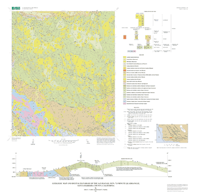
Reconnaissance geologic mapping by H.E. Clifton, D.L. Durham, H. D. Gower, and J.G. Vedder, April-May 1965. Selective geologic mapping, including helicopter overflights, by Hugh McLean and J. G. Vedder, September 1980; September 1981. Detailed geologic mapping of Franciscan Complex by A.D. Wahl, 1990-1992. Detailed geologic mapping by R.G. Stanley and J.G. Vedder, September 1996; June, September, and October 1997. Detailed geologic mapping by R.G. Stanley, June, September, and October 1998.
We thank the United States Department of Agriculture, U.S. Forest Service, for facilitating access to remote parts of the Los Padres National Forest, and the owners and employees of Rancho San Fernando Rey for providing access to private lands. We also thank R.E. Denison (University of Texas at Dallas) for providing a strontium isotopic age on shell material from the unnamed Miocene sandstone (unit Tss); Scott Graham, Zenon Valin, and Todd Fitzgibbon (U.S. Geological Survey, Menlo Park) for assisting with digital preparation of the map; Robert G. Bohannon (U.S. Geological Survey, Menlo Park) and Scott A. Minor (U.S. Geological Survey, Denver, CO) for technical reviews; and Paul Stone (U.S. Geological Survey, Menlo Park) for suggestions that improved the clarity of the map and accompanying materials.
This database and accompanying plot files depict the distribution of geologic materials and structures at a regional (1:24,000) scale. The report is intended to provide geologic information for the regional study of materials properties, earthquake shaking, landslide potential, mineral hazards, mineral and energy resources, seismic velocity, and earthquake faults. In addition, the report contains new information and interpretations about the regional geologic history and framework. However, the regional scale of this report does not provide sufficient detail for site development purposes. In addition, this map does not take the place of fault-rupture hazard zones designated by the California State Geologist (Hart and Bryant, 1997). Similarly, the database cannot be substituted for comprehensive maps that systematically identify and classify landslide hazards.
Are there legal restrictions on access or use of the data?Access_Constraints: None
Use_Constraints:Uses of this digital geologic map should not violate the spatial resolution of the data. Although the digital form of the data removes the constraint imposed by the scale of a paper map, the detail and accuracy inherent in map scale are also present in the digital data. The fact that this database was edited for a scale of 1:24,000 means that higher resolution information is not present in the dataset. Plotting at scales larger than 1:24,000 will not yield greater real detail, although it may reveal fine- scale irregularities below the intended resolution of the database. Similarly, where this database is used in combination with other data of higher resolution, the resolution of the combined output will be limited by the lower resolution of these data.
The U.S. Geological Survey (USGS) provides these geographic data "as is." The USGS makes no guarantee or warranty concerning the accuracy of information contained in the geographic data. The USGS further makes no warranties, either expressed or implied as to any other matter whatsoever, including, without limitation, the condition of the product, or its fitness for any particular purpose. The burden for determining fitness for use lies entirely with the user. Although these data have been processed successfully on computers at the USGS, no warranty, expressed or implied, is made by the USGS regarding the use of these data on any other system, nor does the fact of distribution constitute or imply any such warranty.
In no event shall the USGS have any liability whatsoever for payment of any consequential, incidental, indirect, special, or tort damages of any kind, including, but not limited to, any loss of profits arising out of use of or reliance on the geographic data or arising out of the delivery, installation, operation, or support by USGS.
This digital, geologic map database of the San Rafael Mtn. 7.5'quadrangle, 1:24,000 map-scale, and any derivative maps thereof, is not meant to be used or displayed at any scale larger than 1:24,000 (e.g., 1:12,000).
This report is preliminary and has not been reviewed for conformity with the U.S. Geological Survey editorial standards. Any use of trade, product, or firm names is for descriptive purposes only and does not imply endorsement by the U.S. Government.
| Data format: | Geologic units, structural features, and ancillary coverages, as well as a geo-referenced black-and-white TIF image of the topographic base map in format ARCE (version 7.2.1) Size: 11.3 |
|---|---|
| Network links: |
http://pubs.usgs.gov/of/2001/0290/srm.tar.gz |