Online Links:
| Value | Definition |
|---|---|
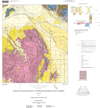
| Qw | Very young wash deposits, arenaceous |
| Qyw | Young wash deposits, arenaceous |
| Qf | Very young alluvial-fan deposits, arenaceous |
| Qv | Very young alluvial-valley deposits, siltey, clayey |
| Qc | Very young colluvial deposits |
| Qlv | Very young lacustrine and fluvial deposits, clayey, silty |
| Qyf | Young alluvial-fan deposits, arenaceous |
| Qyf | Young alluvial-fan deposits, gravel, arenaceous |
| Qyf6 | Young alluvial-fan deposits, Unit 6, gravel, arenaceous |
| Qyf5 | Young alluvial-fan deposits, Unit 5, gravel, arenaceous |
| Qyf4 | Young alluvial-fan deposits, Unit 4, gravel, arenaceous |
| Qyf3 | Young alluvial-fan deposits, Unit 3, gravel, arenaceous |
| Qyf2 | Young alluvial-fan deposits, Unit 2, gravel, arenaceous |
| Qyf1 | Young deposits of alluvial fans, Unit 1, gravel, arenaceous |
| Qya | Young axial-valley floor deposits, arenaceous |
| Qyv | Young alluvial-valley deposits, arenaceous |
| Qyv | Young alluvial-valley deposits, clayey, arenaceous |
| Qyv | Young alluvial-valley deposits, clayey, silty |
| Qyv | Young alluvial-valley deposits, silty, arenaceous |
| Qyv | Young alluvial-valley deposits, silty, clayey |
| Qyv1 | Young alluvial-valley deposits, Unit 1, arenaceous |
| Qyls | Young landslide deposits |
| Qof | Old alluvial-fan deposits, arenaceous |
| Qofv | Old alluvial-fan deposits and very young alluvial-valley deposits, arenaceous |
| Qov | Old alluvial-valley deposits |
| Qoc | Old colluvial deposits |
| Qoc | Old colluvial deposits, gravel |
| Qvof | Very old alluvial-fan deposits, arenaceous |
| Qvof | Very old alluvial-fan deposits, gravel |
| Qvov | Very old alluvial-valley deposits, arenaceous |
| Tstl | San Timoteo beds of Frick (1921) |
| Tmeus | Mount Eden Formation of Fraser (1931), upper sandstone member |
| Tmels | Mount Eden Formation of Fraser (1931), lower sandstone member |
| Tmea | Mount Eden Formation of Fraser (1931), arkosic sandstone member |
| Tmeb | Mount Eden Formation of Fraser (1931), boulder breccia lenses |
| Tmec | Mount Eden Formation of Fraser (1931), conglomeratic sandstone member |
| Kmeg | Granite of Mount Eden |
| Klt | Tonalite of Laborde Canyon |
| Ktcg | Monzogranite of Tres Cerritos |
| Kp | Lakeview Mountains pluton, pegmatite dikes |
| Klmt | Lakeview Mountains pluton, tonalite |
| Klml | Lakeview Mountains pluton, leucocratic tonalite |
| Klmm | Lakeview Mountains pluton, melanocratic tonalite |
| Klmg | Lakeview Mountains pluton, hypersthene-hornblende gabbro |
| Khg | Heterogeneous granitic rocks |
| Krct | Reinhardt Canyon pluton |
| KgPz | Mixed metamorphic rocks and granitic rocks |
| Pzu | Metamorphic rocks, undivided |
| m | Marble |
| Value | Definition |
|---|---|
| C17 | Contact, landslide, location meets map accuracy standard |
| C29 | Contact, sedimentary, location meets map accuracy standard |
| C30 | Contact, sedimentary, location may not meet map accuracy standard |
| C31 | Contact, sedimentary, inferred, location may not meet map accuracy standard |
| C37 | Contact, separates terraced alluvial units, location meets map accuracy standard |
| C41 | Contact, sedimentary, gradational, location may not meet map accuracy standard |
| C49 | Contact, igneous, location meets map accuracy standard |
| C50 | Contact, igneous, location may not meet map accuracy standard |
| C65 | Contact, metamorphic, location meets map accuracy standard |
| CL1 | Cartographic line, map boundary |
| DK9 | Dike, location may not meet map accuracy standard |
| F6 | Fault, high-angle, oblique slip, location meets map accuracy standard |
| F12 | Fault, high-angle, oblique slip, location may not meet map accuracy standard |
| F18 | Fault, high-angle, oblique slip, inferred, location may not meet map accuracy standard |
| F24 | Fault, high-angle, oblique slip, lnferred beneath mapped covering unit |
| F36 | Fault, high-angle, oblique slip, existence questionable, location may not meet map accuracy standard |
| F54 | Fault, high-angle, oblique slip, scarp, location meets map accuracy standard |
| GF9 | Geomorphic feature.ground-failure scarp.certain.may not meet map accuracy standard |
| ML8 | fissure.due to groundwater withdrawal and/or tectonics.certain.may not meet map accuracy standard |
| Value | Definition |
|---|---|
| B1 | Bedding attitude, sedimentary, horizontal |
| B2 | Bedding attitude, sedimentary, inclined |
| B4 | Bedding attitude, sedimentary, vertical |
| B14 | Bedding attitude, sedimentary, inclined, indicated, not measured |
| FN4 | Foliation, inclined, indicated but not measured |
| FN13 | Foliation, igneous, inclined |
| FN14 | Foliation. igneous, vertical |
| FN42 | Foliation, metamorphic, inclined |
| FN43 | Foliation, metamorphic, vertical |
Technical review by M. Dawson and F. Miller led to significant improvements that eventually were reflected in aspects of the database, the plot file, and in the description of the geologic units of the Lakeview 7.5' quadrangle. Digital review by R.W. Graymer has allowed us to prepare a much improved product.
Geologic mapping and digital preparation of this report were sponsored jointly by (1) the National Cooperative Geologic Mapping Program of the U.S. Geological Survey, (2) the California Division of Mines and Geology, and (3) the Southern California Areal Mapping Project (SCAMP). The digital preparation of the data set was carried out by Rachel Alvarez and Gary Patt at the SCAMP Geographic Information System laboratory in Riverside, and by Pamela M. Cossette at the USGS Mineral Resources Program GIS lab in Spokane, Washington.
The data set for the Lakeview quadrangle has been prepared by the Southern California Areal Mapping Project (SCAMP), a cooperative project sponsored jointly by the U.S. Geological Survey and the California Division of Mines and Geology. The Lakeview data set represents part of an ongoing effort to create a regional GIS geologic database for southern California. This regional digital database, in turn, is being developed as a contribution to the National Geologic Map Database of the National Cooperative Geologic Mapping Program of the USGS.
The digital geologic map database for the Lakeview 7.5' quadrangle has been created as a general-purpose data set that is applicable to other land-related investigations in the earth and biological sciences. For example, it can be used for groundwater studies in the San Bernardino basin, and for mineral resource evaluation studies, animal and plant habitat studies, and soil studies in the San Bernardino National Forest. The database is not suitable for site-specific geologic evaluations.
Are there legal restrictions on access or use of the data?Access_Constraints: None
Use_Constraints:The Lakeview 7.5' geologic-map database should be used to evaluate and understand the geologic character of the Lakeview 7.5' quadrangle as a whole. The data should not be used for purposes of site-specific land-use planning or site-specific geologic evaluations. The database is sufficiently detailed to identify and characterize geologic materials and structures. However, it is not sufficiently detailed for site-specific determinations.
Use of this digital geologic map database should not violate the spatial resolution of the data. Although the digital form of the data removes the constraint imposed by the scale of a paper map, the detail and accuracy inherent in map scale are also present in the digital data. The fact that this database was compiled and edited at a scale of 1:24,000 means that higher resolution information may not have been uniformly retained in the dataset. Plotting at scales larger than 1:24,000 will not yield greater real detail, although it may reveal fine-scale irregularities below the intended resolution of the database. Similarly, although higher resolution data is incorporated in parts of the map, the resolution of the combined output will be limited by the lower resolution data.
The U.S. Geological Survey (USGS) provides these geographic data "as is." The USGS makes no guarantee or warranty concerning the accuracy of information contained in the geographic data. The USGS further makes no warranties, either expressed or implied as to any other matter whatsoever, including, without limitation, the condition of the product, or its fitness for any particular purpose. The burden for determining fitness for use lies entirely with the user. Although these data have been processed successfully on computers at the USGS, no warranty, expressed or implied, is made by the USGS regarding the use of these data on any other system, nor does the fact of distribution constitute or imply any such warranty.
In no event shall the USGS have any liability whatsoever for payment of any consequential, incidental, indirect, special, or tort damages of any kind, including, but not limited to, any loss of profits arising out of use of or reliance on the geographic data or arising out of delivery, installation, operation, or support by USGS.
This digital, geologic map database of the Lakeview 7.5'quadrangle, 1:24,000 map-scale, and any derivative maps thereof, is not meant to be used or displayed at any scale larger than 1:24,000 (e.g., 1:12,000).
| Data format: | Geologic units, structural features in format ARCE (version 7.2.1) Size: 2.3 |
|---|---|
| Network links: |
http://pubs.usgs.gov/of/2001/0174/lkvw.tar.gz |