Geologic map of the Rio Puerco quadrangle, Bernalillo and Valencia Counties, New Mexico

Metadata also available as - [Outline] - [Parseable text] - [XML]

Frequently anticipated questions:


What does this data set describe?

Title:
Geologic map of the Rio Puerco quadrangle, Bernalillo and Valencia Counties, New Mexico
Abstract:
The Rio Puerco quadrangle is located southwest of Albuquerque in central New Mexico and covers part of the western part of the Isleta Reservation. The U.S. Geological Survey, the New Mexico Bureau of Geology and Mineral Resources, and the University of New Mexico have conducted geologic mapping on the Isleta Reservation and vicinity as part of the Middle Rio Grande Basin Project. The map area contains surficial deposits, calcic soils, fluvial deposits of the Rio Puerco, deposits of the Santa Fe Group, and three volcanic fields. The area is characterized by predominantly north-trending normal faults with generally down-to-the-east movement.
Post-Santa Fe Group deposits are composed of surficial deposits (Pleistocene-Holocene) and fluvial deposits of the Rio Puerco (Pleistocene-Holocene). The surficial deposits are divided into eolian, alluvial, colluvial, and landslide deposits. The fluvial deposits of the Rio Puerco consist of four terrace and present channel deposits.
The Santa Fe Group is divided into lower and upper parts. The lower part of the Santa Fe Group is exposed near the southwestern corner of the study area where deposits consist of reddish-brown mudstone and sandstone correlated to the Popotosa Formation (Unit 1) of Lozinsky and Tedford (1991). They interpreted deposition of the unit in a basin-floor playa setting. The Popotosa Formation is in fault contact to the east with deposits of the upper Santa Fe Group. The upper Santa Fe Group is derived from major tributary fluvial systems (ancestral Rio Puerco Puerco and possibly the Rio San Jose drainages) draining the adjacent Colorado Plateau and Sierra Nacimiento and correlated to parts of Kelley's (1977) Ceja Formation of the Santa Fe Group and equivalent to Machette's (1978) Sierra Ladrones Formation, Connell's Arroyo Ojito Formation (Connell and others, 1999, and Maldonado's lithofacies of the Isleta Reservation (Maldonado and Atencio,1998a, b). The group also locally includes a fine- grained unit (lower Pleistocene) referred to here as the sand, silt, and clay of Chavez Grant (Qsc). The Ceja Formation of the Santa Fe Group as defined here is divided into the following units in descending stratigraphic order: (1) upper sand and gravel unit (upper Pliocene), (2) middle silt, sand, and clay unit (upper Pliocene), and (3) lower sand and gravel unit (Pliocene).
The three volcanic fields in the map area are: (1) basalt of Cat Hills, dated at 98-110 ka and composed of seven lava flows and four cinder cones; the flows overlie calcic soils that overlie the upper sand and gravel unit of the Ceja Formation; (2) lava flow of Cat Mesa, dated at about 3 Ma and interfingers with the upper part of the Ceja Formation; (3) diabase of Mohinas Mountain, dated at 8.3 Ma (Baldridge and others, 1987) and intrudes the Popotosa Formation.
Numerous high-angle faults cut the area but are mostly buried. The faults generally trend north but deviate to the northwest and northeast. The major normal faults are the Cat Mesa and Mohinas Mountain faults.
Supplemental_Information:
Compilation scale 1:24000
Geology mapped 1998-1999.
Geospatial datafiles and other files included in this data set:
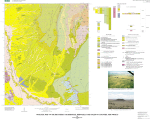
rp_geol: geologic units and "shared" fault/contacts
rp_line: faults not "shared" in rp-geol coverage
rp_pnt: bedding and sample locations
base map: riopuerco.tif and riopuerco.tfw
ArcInfo shadeset: ctr269.shd
  1. How might this data set be cited?
    Maldonado, Florian, 2003, Geologic map of the Rio Puerco quadrangle, Bernalillo and Valencia Counties, New Mexico: U.S. Geological Survey Miscellaneous Field Studies Map MF-2397, U.S. Geological Survey, Denver, Colorado.

    Online Links:

  2. What geographic area does the data set cover?
    West_Bounding_Coordinate: -107.00
    East_Bounding_Coordinate: -106.875
    North_Bounding_Coordinate: 34.875
    South_Bounding_Coordinate: 34.75
  3. What does it look like?
    http://pubs.usgs.gov/mf/2003/mf-2397/mf-2397.gif (GIF)
    Reduced-size image of the map sheet, 300x239 pixels, 38k bytes.
    http://pubs.usgs.gov/mf/2003/mf-2397/mf-2397.pdf (PDF)
    Printable representation of map, 1.6 megabytes
  4. Does the data set describe conditions during a particular time period?
    Calendar_Date: 2003
    Currentness_Reference:
    Publication date
  5. What is the general form of this data set?
    Geospatial_Data_Presentation_Form: map
  6. How does the data set represent geographic features?
    1. How are geographic features stored in the data set?
      This is a Vector data set.
    2. What coordinate system is used to represent geographic features?
      Grid_Coordinate_System_Name: Universal Transverse Mercator
      Universal_Transverse_Mercator:
      UTM_Zone_Number: 13
      Transverse_Mercator:
      Scale_Factor_at_Central_Meridian: 0.9996
      Longitude_of_Central_Meridian: -105.0
      Latitude_of_Projection_Origin: 0.0
      False_Easting: 500000.0
      False_Northing: 0.0
      Planar coordinates are encoded using coordinate pair
      Abscissae (x-coordinates) are specified to the nearest 20
      Ordinates (y-coordinates) are specified to the nearest 20
      Planar coordinates are specified in METERS
      The horizontal datum used is North American Datum of 1927.
      The ellipsoid used is Clarke 1866.
      The semi-major axis of the ellipsoid used is 6378206.4.
      The flattening of the ellipsoid used is 1/294.98.
  7. How does the data set describe geographic features?
    Entity_and_Attribute_Overview:
    The data are supplied in ARC/INFO export format and ArcView shapefiles.
    Dataset consists of three main (map) coverages:
    rp_geol
    rp_line
    rp_pnt
    
    <RP_GEOL.PAT>
    
    COLUMN  ITEM NAME   WIDTH  OUTPUT  TYPE  N.DEC  ALTERNATE NAME    INDEXED?
    1       AREA            8     18      F      5                       -
    9       PERIMETER       8     18      F      5                       -
    17      RP_GEOL#        4      5      B      -                       -
    21      RP_GEOL-ID      4      5      B      -                       -
    25      DESCRIPTION    80     80      C      -                       -
    105     LABEL           8      8      C      -                       -
    113     SYMBOL          3      3      I      -                       -
    
    LABEL     SYMBOL  DESCRIPTION
    Qac         5      Alluvial and colluvial deposits (Holocene)
    Qal         3      Alluvial deposits (Holocene)
    Qcc        10      Cinder deposit of Cat Hills cones (Pleistocene)
    Qch1       87      Lava flow 1 of Cat Hills (upper Pleistocene)
    Qch2       85      Lava flow 2 of Cat Hills (upper Pleistocene)
    Qch3       42      Lava flow 3 of Cat Hills (upper Pleistocene)
    Qch4       41      Lava flow 4 of Cat Hills (upper Pleistocene)
    Qch5       17      Lava flow 5 Cat Hills (upper Pleistocene)
    Qch6       15      Lava flow 6 of Cat Hills (upper Pleistocene)
    Qch7       13      Lava flow 7 of Cat Hills (upper Pleistocene)
    Qe         82      Eolian sand deposits (Holocene and upper Pleistocene)
    Qe/Qac     80      Eolian sand veneer on alluvial and colluvial deposits
                        (Holocene and upper Pleistocene)
    Qe/Qsc    225      Eolian sand veneer on sand, silt, and clay unit of
                         Chavez Grant (Holocene to lower Pleistocene)
    Qe/Tscl   219      Eolian sand veneer on the lower sand and gravel of the
                         Ceja Formation (Holocene to Pliocene)
    Qe/Tscu    81      Eolian sand veneer on soils of the upper sand and
                         gravel unit of the Ceja Formation (Holocene to upper
                         Pliocene)
    Qec        38      Eolian and colluvial deposits (Holocene and upper
                         Pleistocene)
    --        267      Calcic soils 1 (Pleistocene)
    --        172      Calcic soils 2 (Pleistocene)
    Qls        51      Landslide deposits (Holocene to middle Pleistocene)
    Qrc        60      Present channel and tributary deposits (Holocene)
    Qrp       147      Fluvial deposits of the ancestral Rio Puerco (upper
                         Pleistocene)
    Qrt1        7      Old terrace deposits (Holocene)
    Qrt2        9      Intermediate terrace deposits (Holocene)
    Qrt3       11      Young terrace deposits (Holocene)
    Qsc       223      Sand, silt, and clay unit of Chavez Grant (lower
                         Pleistocene)
    Tcm        86      Lava flow of Cat Mesa (upper Pliocene)
    --         78      Calcic soils underlying Llano de Albuquerque
                         (Pliocene-Pleistocene)
    Tm        255      Diabase of Mohinas Mountain (Miocene)
    Tsp       243      Popotosa Formation (Miocene and upper Oligocene)
    Tscl      221      Lower sand and gravel unit of the Ceja Formation
                         (upper Pliocene)
    Tscm      219      Middle silt, sand, and clay unit of the Ceja Formation
                         (upper Pliocene)
    Tscm?     219      Middle silt, sand, and clay unit of the Ceja Formation
                         (upper Pliocene)
    Tscu       62      Upper sand and gravel unit of the Ceja Formation (upper
                         Pliocene)
    --        --       crater
    
    <RP_GEOL.AAT>
    
    COLUMN  ITEM NAME   WIDTH  OUTPUT  TYPE  N.DEC  ALTERNATE NAME    INDEXED?
    1       FNODE#          4      5      B      -                        -
    5       TNODE#          4      5      B      -                        -
    9       LPOLY#          4      5      B      -                        -
    13      RPOLY#          4      5      B      -                        -
    17      LENGTH          8     18      F      5                        -
    25      RP_GEOL#        4      5      B      -                        -
    29      RP_GEOL-ID      4      5      B      -                        -
    33      DESCRIPTION    80     80      C      -                        -
    113     SYMBOL          3      3      I      0                        -
    
    SYMBOL        DESCRIPTION
    1             Contact-Certain
    5             Contact-Inferred, queried
    51            Normal fault-Certain
    54            Fault-Concealed, queried
    56            Rim of volcanic crater--Certain
    216           Fault-Approximately located
    227           Map boundary
    313           Normal fault-Concealed, queried
    
    <RP_LINE.AAT>
    
    COLUMN  ITEM NAME   WIDTH  OUTPUT  TYPE  N.DEC  ALTERNATE NAME    INDEXED?
    1       FNODE#          4       5     B      -                        -
    5       TNODE#          4       5     B      -                        -
    9       LPOLY#          4       5     B      -                        -
    13      RPOLY#          4       5     B      -                        -
    17      LENGTH          8      18     F      5                        -
    25      RP_LINE#        4       5     B      -                        -
    29      RP_LINE-ID      4       5     B      -                        -
    33      DESCRIPTION    80      80     C      -                        -
    113     SYMBOL          3       3     I      0                        -
    
    SYMBOL        DESCRIPTION
    134           Fault-Located by aeromagnetic survey
    175           Fault-Concealed, queried
    176           Fault-Concealed
    186           Normal fault-Concealed
    314           Normal fault-Concealed, queried
    
    <RP_PNT.PAT>
    
    COLUMN  ITEM NAME   WIDTH  OUTPUT  TYPE  N.DEC  ALTERNATE NAME    INDEXED?
    1       AREA            8      18     F      5                        -
    9       PERIMETER       8      18     F      5                        -
    17      RP_PNT#         4       5     B      -                        -
    21      RP_PNT-ID       4       5     B      -                        -
    25      AZIMUTH         7       7     I      -    ROTATION            -
    32      DIP             3       3     I      -    INCLINATION         -
    35      DESCRIPTION    80      80     C      -                        -
    115     AGE            20      20     C      -                        -
    135     SYMBOL          3       3     I      0                        -
    
    SYMBOL        DESCRIPTION
    1             Horizontal bedding
    2             Inclined bedding - Showing strike and dip
    232           Age determination sample location
    
    AZIMUTH
    Compass direction of fault plane trend, in degrees
    Range of values: 0-359
    
    DIP
    Angle of fault plane inclination, in degrees from horizontal
    Range of values: 0-90
    
    AGE
    Age of sample location
    
    Entity_and_Attribute_Detail_Citation: http://pubs.usgs.gov/mf/2003/mf-2397/mf-2397_508.pdf

Who produced the data set?

  1. Who are the originators of the data set? (may include formal authors, digital compilers, and editors)
    • Florian Maldonado
  2. Who also contributed to the data set?
  3. To whom should users address questions about the data?
    Florian Maldonado
    U.S. Geological Survey
    MS 913, Box 25046 DFC
    Denver, CO
    U.S.A.

    303-236-1281 (voice)
    fmaldona@usgs.gov

Why was the data set created?

To conduct new geologic mapping and to provide geologic information for land-use decisions and water management, as part of the U.S. Geological Survey's Middle Rio Grande Project. Mapping of this quadrangle will also be used to compile parts of the Isleta 1:50,000-scale geologic map.

How was the data set created?

  1. From what previous works were the data drawn?
  2. How were the data generated, processed, and modified?
    Date: 1999 (process 1 of 9)
    Polygons, lines, and points representing geologic features and data points were digitized from scale-stable compilation materials using the GSMCAD public domain program (USGS Open-File Report 96-007).
    Date: 1999 (process 2 of 9)
    The map data were exported to ARC/INFO using the GSMCAD export function to create ARC generate ASCII files. The ASCII files were then imported into ArcInfo using the GENERATE routine, and polygon topology built.
    Date: 1999 (process 3 of 9)
    The gsmdraw.aml program was used in ARC to produce a graphics file of the colored map. In addition an explanation sheet was produced that includes a correlation of map units diagram, a list of map unit names and corresponding symbols, and an explanation of graphical map symbols.
    Date: 2000 (process 4 of 9)
    Text map unit descriptors were added to the .AAT and .PAT database files for each coverage.
    Date: 2000 (process 5 of 9)
    Draft check plots of the geologic map and explanation were created and submitted for peer review. Geologists reviewed the plots for conformity with U.S. Geological Survey editorial standards and stratigraphic nomenclature. Revisions were made to the geospatial database as needed.
    Date: 2002 (process 6 of 9)
    The database files, metadata, and check plots were edited by the USGS Central Publications Group, and revisions made to the geospatial database as needed.
    Date: 2002 (process 7 of 9)
    The geospatial database files and metadata were quality checked for completeness and consistency.
    Date: 2003 (process 8 of 9)
    Final preparation of the geospatial database for distribution.
    Date: 12-Jun-2009 (process 9 of 9)
    Creation of original metadata record Person who carried out this activity:
    Paco VanSistine
    U.S. Geological Survey
    MS 913, Box 25046 DFC
    Lakewood, CO

    303-236-5452 (voice)
    dsistine@usgs.gov
  3. What similar or related data should the user be aware of?

How reliable are the data; what problems remain in the data set?

  1. How well have the observations been checked?
    Data were entered and checked by the geologist that made the field observations. The attributes of this geospatial dataset consist of text identifiers and numeric codes that indicate the identity of the geologic unit or type of geologic feature, and determine how each feature is colored or symbolized. To check attribute accuracy, a color check plot was visually compared to the geologist's original compilation. Discrepancies between the digital geospatial data set and the original analog compilation were corrected as needed. Machine-created listings of unique attribute values were used to identify spelling errors or other inconsistencies, and corrections were made as needed. This map has been thoroughly reviewed for conformity with U.S. Geological Survey editorial standards and stratigraphic nomenclature.
  2. How accurate are the geographic locations?
    For some of the quadrangles, lines were primarily mapped by photointerpretation of 1:24,000-scale color aerial photographs using a PG-2 photogrammetric plotter that rectified the position and transferred it to a basemap. Lines were digitized from the basemap using a digitizer tablet with resolution of 0.001 inches, and most digitized positions on the map are estimated to have about 20 m horizontal accuracy. There is no elevation data in the database.
  3. How accurate are the heights or depths?
  4. Where are the gaps in the data? What is missing?
    Data are complete. No features that could be accurately represented at the compilation scale of 1:24,000 were eliminated or generalized. All geospatial database elements are attributed.
  5. How consistent are the relationships among the observations, including topology?
    Map elements were visually checked for overshoots, undershoots, duplicate features, polygon closure, and other errors by the author and by the GIS technician(s) that created the digital database. Automated (ArcInfo) routines were also used to check the databases for polygon label errors, line or point attribution errors, sliver polygons, dangling arcs, intersection errors, and projection information. Check plots of the map were reviewed by at least two other geologists for consistency with basic geologic principles and general conformity to USGS mapping standards.

How can someone get a copy of the data set?

Are there legal restrictions on access or use of the data?
Access_Constraints: None
Use_Constraints:
None. Acknowledgment of the U.S. Geological Survey would be appreciated in products derived from these data.
  1. Who distributes the data set? (Distributor 1 of 1)
    U.S. Geological Survey
    Central Publications Group
    Denver, CO

    303-236-5486 (voice)
  2. What's the catalog number I need to order this data set? USGS Miscellaneous Field Studies Map MF-2397
  3. What legal disclaimers am I supposed to read?
    Although this digital spatial data has been subjected to rigorous review and is substantially complete, it is released on the condition that neither the USGS nor the United States Government may be held liable for any damages resulting from its authorized or unauthorized use.
  4. How can I download or order the data?

Who wrote the metadata?

Dates:
Last modified: 13-Jun-2016
Metadata author:
Peter N Schweitzer
USGS Midwest Area
Collection manager, USGS Geoscience Data Clearinghouse, http://geo-nsdi.er.usgs.gov/
Mail Stop 954
12201 Sunrise Valley Dr
Reston, VA
USA

703-648-6533 (voice)
703-648-6252 (FAX)
pschweitzer@usgs.gov
Metadata standard:
Content Standard for Digital Geospatial Metadata (FGDC-STD-001-1998)

This page is <https://geo-nsdi.er.usgs.gov/metadata/map-mf/2397/metadata.faq.html>
Generated by mp version 2.9.48 on Tue Jul 03 20:05:17 2018