Geologic map of the Battle Ground 7.5-minute quadrangle, Clarke County, Washington

Metadata also available as - [Questions & Answers] - [Parseable text] - [XML]

Metadata:

Identification_Information:
Citation:
Citation_Information:
Originator: Keith A. Howard
Publication_Date: 2002
Title:
Geologic map of the Battle Ground 7.5-minute quadrangle, Clarke County, Washington
Geospatial_Data_Presentation_Form: vector digital data
Series_Information:
Series_Name: U.S. Geological Survey Miscellaneous Field Studies Map
Issue_Identification: MF-2395
Online_Linkage: http://pubs.usgs.gov/mf/2002/2395/
Description:
Abstract:
This digital map database, compiled from previously published and unpublished data, and new mapping by the authors, represents the general distribution of bedrock and surficial deposits of the Battle Ground 7.5 minute quadrangle. The database delineates map units that are identified by general age and lithology following the stratigraphic nomenclature of the U.S. Geological Survey. The scale of the source maps limits the spatial resolution (scale) of the database to 1:24,000 or smaller.
Purpose:
This database and accompanying plot files depict the distribution of geologic materials and structures at a regional (1:24,000) scale. The report is intended to provide geologic information for the regional study of materials properties, earthquake shaking, landslide potential, mineral hazards, seismic velocity, and earthquake faults. In addition, the report contains new information and interpretations about the regional geologic history and framework. However, the regional scale of this report does not provide sufficient detail for site development purposes.
Time_Period_of_Content:
Time_Period_Information:
Single_Date/Time:
Calendar_Date: 2002
Currentness_Reference: Publication date
Status:
Progress: Complete
Maintenance_and_Update_Frequency: As needed
Spatial_Domain:
Bounding_Coordinates:
West_Bounding_Coordinate: -122.625838
East_Bounding_Coordinate: -122.498880
North_Bounding_Coordinate: 45.875479
South_Bounding_Coordinate: 45.749522
Keywords:
Theme:
Theme_Keyword_Thesaurus: USGS Thesaurus
Theme_Keyword: geology
Theme_Keyword: bedrock geologic units
Theme_Keyword: surficial geologic units
Theme_Keyword: geologic history
Theme_Keyword: geologic structure
Theme_Keyword: faulting (geologic)
Theme:
Theme_Keyword_Thesaurus: ISO 19115 Topic Categories
Theme_Keyword: geoscientificInformation
Place:
Place_Keyword_Thesaurus: USGS 7.5 minute quadrangle names
Place_Keyword: Battle Ground, WA
Place:
Place_Keyword_Thesaurus: US states
Place_Keyword: Washington
Place:
Place_Keyword_Thesaurus: Augmented FIPS 10-4 and FIPS 6-4
Place_Keyword: f53011 = Clark
Access_Constraints: None
Use_Constraints:
Uses of this digital geologic map should not violate the spatial resolution of the data. Although the digital form of the data removes the constraint imposed by the scale of a paper map, the detail and accuracy inherent in map scale are also present in the digital data. The fact that this database was edited for a scale of 1:24,000 means that higher resolution information is not present in the dataset. Plotting at scales larger than 1:24,000 will not yield greater real detail, although it may reveal fine-scale irregularities below the intended resolution of the database. Similarly, where this database is used in combination with other data of higher resolution, the resolution of the combined output will be limited by the lower resolution of these data.
Browse_Graphic:
Browse_Graphic_File_Name: http://pubs.usgs.gov/mf/2002/2395/images/bgweb.jpg
Browse_Graphic_File_Description:
Reduced-size image of the entire map sheet, 350x400 pixels, 26k bytes.
Browse_Graphic_File_Type: JPEG
Browse_Graphic:
Browse_Graphic_File_Name: http://pubs.usgs.gov/mf/2002/2395/bgmap.pdf
Browse_Graphic_File_Description: Printable version of the entire map, 11.9MB.
Browse_Graphic_File_Type: PDF
Native_Data_Set_Environment: UNIX, ARC/Info 8.1
Data_Quality_Information:
Attribute_Accuracy:
Attribute_Accuracy_Report:
Unit identification and database field values were checked by a standard USGS review for publication. Geological review by R.C. Evarts and R.B. Waitt. Edited by J.L. Ziglar.
Logical_Consistency_Report:
Most map contacts are approximate or inferred. Rock colors are designated using letters and numbers in the Munsell system. Geologic map units are defined by lithostratigraphic criteria (for instance the Skamania Volcanics) and in some cases also by allostratigraphic criteria where geomorphic surfaces help to define units (North American Commision on Stratigraphic Nomenclature, 1983). For example, depositional landforms help define the older alluvium unit and the alluvialfan member of the Troutdale Formation.
Positional_Accuracy:
Horizontal_Positional_Accuracy:
Horizontal_Positional_Accuracy_Report:
The base map for the digital compilation is a Digital Raster Graphic (DRG) of the U.S. Geological Survey, 1:24,000-scale topographic map of the Battle Ground 7.5' quadrangle (1990), which has a 10-foot contour interval. The image inside the map neatline is georeferenced to the Universal Transverse Mercator projection. The horizontal positional accuracy and datum of the DRG matches the accuracy and datum of the source map. These base map/geology layers are digital images but no information other than location is attached to the lines. The base/geology maps are provided for reference only.
Lineage:
Source_Information:
Source_Citation:
Citation_Information:
Originator: Mundorff, M.J.
Title:
Geology and ground-water conditions of Clark County, Washington, with a description of a major alluvial aquifer along the Columbia River
Publication_Date: 1964
Series_Information:
Series_Name: U.S. Geological Survey Water-Supply Paper
Issue_Identification: 1600
Source_Scale_Denominator: 48000
Type_of_Source_Media: paper
Source_Time_Period_of_Content:
Time_Period_Information:
Single_Date/Time:
Calendar_Date: 1964
Source_Currentness_Reference: publication date
Source_Citation_Abbreviation: Mundorff (1964)
Source_Contribution:
Mundorff (1964) laid an excellent geologic foundation for this quadrangle in his description and geologic map of Clark County. The present more detailed map further subdivides some of the units he mapped and offers some reinterpretations.
Process_Step:
Process_Description:
Soil and vegetation hide many geologic features in the area, and suburban development hinders access behind the many roads. For the present study, observations from 21 days of field mapping were compared against logs, summaries, and interpretations of field-located water wells (Mundorff, 1964; Swanson and others, 1993) and supplemented by interpreting drillers logs of about 1,000 approximately located water wells. The resulting geologic-map interpretation relies on key outcrops, on geomorphic position of units, and on the well logs to indicate the projected surface positions of poorly exposed units. Several dozen well logs supplemented the field observations used to draw (vertically exaggerated) cross section A-A', for example.
Process_Step:
Process_Description:
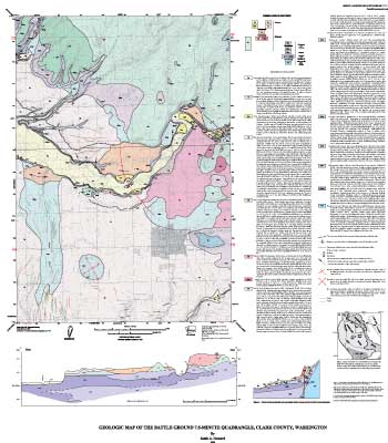
This digital map publication, generated from new mapping by the author, shows the general distribution of bedrock and surficial deposits in the Battle Ground 7.5' quadrangle. Together with the accompanying geologic description pamphlet, it presents current knowledge of the geologic structure and stratigraphy of the area covered. The database identifies map units that are classified by general age and lithology following the stratigraphic nomenclature of the U.S. Geological Survey. The scale of the source map limits the spatial resolution (scale) of the database to 1:24,000 or smaller. The content and character of the digital publication, as well as methods of obtaining the digital files, are described below.
The databases in this report were compiled in ARC/INFO, a commercial Geographic Information System by Environmental Systems Research Institute (ESRI) in Redlands, California, with version 3.0 of the menu interface ALACARTE (Fitzgibbon and Wentworth, 1991; Fitzgibbon, 1991; Wentworth and Fitzgibbon, 1991). The files are in either GRID (ARC/INFO raster data) format or COVERAGE (ARC/INFO vector data) format. Coverages are stored in uncompressed ARC export format (ARC/INFO version 8.1.2 for Unix). ARC/INFO export files (files with the .e00 extension) can be converted into ARC/INFO coverages in ARC/INFO (see below) and can be read by some other Geographic Information Systems, such as MapInfo, via ArcLink and ESRI's ArcView (version 1.0 for Windows 3.1 to 3.11 is available for free from ESRI's web site: http://www.esri.com). The digital compilation was done in version 8.1.2 of ARC/INFO for Unix.
Several different coverages were generated during the construction of the Battle Ground quadrangle geologic map. The topographic base map remains as an image and then is converted to a grid, and is merged at the last step with the colored geology polygrids. The image was merged with the geology grid to give an apparent transparent color image of both combined. The raster geology grids were converted to vector coverages with ARC/INFO's gridline routine. Alacarte and some custom menus and AMLs (ARC Macro Language) were used to project, transform, edit, tag, and build lines, polygons, and points in the map. A digital layout or map collar was made with Adobe Illustrator. The plot AMLs run in ARC/INFO and call the coverages, grids, and Adobe Illustrator EPS files to make uncompressed PostScript files.
Process_Contact:
Contact_Information:
Contact_Person_Primary:
Contact_Person: Philip A Dinterman
Contact_Organization: U.S. Geological Survey, GEO-WRG-NGM
Contact_Address:
Address_Type: mailing address
Address:
Mail Stop 975
345 Middlefield Road
City: Menlo Park
State_or_Province: CA
Postal_Code: 94025
Country: USA
Contact_Voice_Telephone: 650-329-4902
Contact_Facsimile_Telephone: 650-329-4936
Contact_Electronic_Mail_Address: pdinterman@usgs.gov
Process_Step:
Process_Description: Creation of original metadata record
Process_Date: 20020205
Process_Contact:
Contact_Information:
Contact_Person_Primary:
Contact_Person: Karen L Wheeler
Contact_Organization: U.S. Geological Survey, GEO-WRG-NGM
Contact_Position: Geologist
Contact_Address:
Address_Type: mailing address
Address:
Mail Stop 975
345 Middlefield Road
City: Menlo Park
State_or_Province: CA
Postal_Code: 94025
Country: USA
Contact_Voice_Telephone: 650-329-4935
Contact_Facsimile_Telephone: 650-329-4936
Contact_Electronic_Mail_Address: kwheeler@usgs.gov
Spatial_Data_Organization_Information:
Direct_Spatial_Reference_Method: Vector
Point_and_Vector_Object_Information:
SDTS_Terms_Description:
SDTS_Point_and_Vector_Object_Type: Complete chain
SDTS_Terms_Description:
SDTS_Point_and_Vector_Object_Type: Label point
SDTS_Terms_Description:
SDTS_Point_and_Vector_Object_Type: GT-polygon composed of chains
SDTS_Terms_Description:
SDTS_Point_and_Vector_Object_Type: Point
Spatial_Reference_Information:
Horizontal_Coordinate_System_Definition:
Planar:
Map_Projection:
Map_Projection_Name: Transverse Mercator
Transverse_Mercator:
Scale_Factor_at_Central_Meridian: 0.9996
Longitude_of_Central_Meridian: -123
Latitude_of_Projection_Origin: 0.0
False_Easting: 500000
False_Northing: 0.0
Planar_Coordinate_Information:
Planar_Coordinate_Encoding_Method: coordinate pair
Coordinate_Representation:
Abscissa_Resolution: 0.000032
Ordinate_Resolution: 0.000032
Planar_Distance_Units: meters
Geodetic_Model:
Horizontal_Datum_Name: D_Clarke_1866
Ellipsoid_Name: Clarke 1866
Semi-major_Axis: 6378206.4
Denominator_of_Flattening_Ratio: 294.978698
Entity_and_Attribute_Information:
Detailed_Description:
Entity_Type:
Entity_Type_Label: bat_geo.pat
Entity_Type_Definition: Geologic units
Attribute:
Attribute_Label: PTYPE
Attribute_Definition: Geologic unit designation
Attribute_Domain_Values:
Enumerated_Domain:
Enumerated_Domain_Value: Qa
Enumerated_Domain_Value_Definition: Young alluvium (Holocene)
Attribute_Domain_Values:
Enumerated_Domain:
Enumerated_Domain_Value: Ql
Enumerated_Domain_Value_Definition: Landslides and basalt talus (Holocene)
Attribute_Domain_Values:
Enumerated_Domain:
Enumerated_Domain_Value: Qoa
Enumerated_Domain_Value_Definition: Older alluvium (upper Pleistocene?)
Attribute_Domain_Values:
Enumerated_Domain:
Enumerated_Domain_Value: Qf
Enumerated_Domain_Value_Definition: Fine-grained catastrophic flood deposits (upper Pleistocene)
Attribute_Domain_Values:
Enumerated_Domain:
Enumerated_Domain_Value: Qt
Enumerated_Domain_Value_Definition: Terrace deposits (upper Pleistocene)
Attribute_Domain_Values:
Enumerated_Domain:
Enumerated_Domain_Value: Qb
Enumerated_Domain_Value_Definition: Basalt of Battle Ground (upper Pleistocene)
Attribute_Domain_Values:
Enumerated_Domain:
Enumerated_Domain_Value: Qbs
Enumerated_Domain_Value_Definition: Basalt scoria
Attribute_Domain_Values:
Enumerated_Domain:
Enumerated_Domain_Value: Qd
Enumerated_Domain_Value_Definition: Glacial drift (Pleistocene)
Attribute_Domain_Values:
Enumerated_Domain:
Enumerated_Domain_Value: QTta
Enumerated_Domain_Value_Definition:
Alluvial-fan member of Troutdale Formation (Pleistocene and/or Pliocene)
Attribute_Domain_Values:
Enumerated_Domain:
Enumerated_Domain_Value: QTtv
Enumerated_Domain_Value_Definition:
Volcanic-clast member of the Troutdale Formation (Pleistocene or Pliocene)
Attribute_Domain_Values:
Enumerated_Domain:
Enumerated_Domain_Value: QTtq
Enumerated_Domain_Value_Definition: Quartzite-clast member of the Troutdale Formation (Pliocene)
Attribute_Domain_Values:
Enumerated_Domain:
Enumerated_Domain_Value: QTtf
Enumerated_Domain_Value_Definition:
Fine-grained member of the Troutdale Formation (Pliocene and Miocene?)
Attribute_Domain_Values:
Enumerated_Domain:
Enumerated_Domain_Value: QTtfs
Enumerated_Domain_Value_Definition: Sand facies of the Troutdale Formation
Attribute_Domain_Values:
Enumerated_Domain:
Enumerated_Domain_Value: Tsv
Enumerated_Domain_Value_Definition: Skamania Volcanics
Detailed_Description:
Entity_Type:
Entity_Type_Label: bg_stx.pat
Entity_Type_Definition: Linear structural geologic features
Attribute:
Attribute_Label: LTYPE
Attribute_Definition: Structural feature type (string of width )
Attribute_Domain_Values:
Enumerated_Domain:
Enumerated_Domain_Value: dome, certain
Enumerated_Domain_Value_Definition:
long axis of dome structure, well established by observation and inference
Attribute_Domain_Values:
Enumerated_Domain:
Enumerated_Domain_Value: f.a., syncline, concealed
Enumerated_Domain_Value_Definition: synclinal fold axis, inferred
Attribute_Domain_Values:
Enumerated_Domain:
Enumerated_Domain_Value: f.a., syncline, certain
Enumerated_Domain_Value_Definition: synclinal fold axis, observed
Distribution_Information:
Distributor:
Contact_Information:
Contact_Organization_Primary:
Contact_Organization: U.S. Geological Survey
Contact_Position: Database Coordinator
Contact_Address:
Address_Type: mailing address
Address: 345 Middlefield Rd., M/S 975
City: Menlo Park
State_or_Province: CA
Postal_Code: 94025
Country: USA
Contact_Voice_Telephone: 650-329-4935
Contact_Facsimile_Telephone: 650-329-4936
Contact_Electronic_Mail_Address: kwheeler@usgs.gov
Resource_Description: USGS Miscellaneous Field Studies Map MF-2395
Distribution_Liability:
Any use of trade, product, or firm names is for descriptive purposes only and does not imply endorsement by the U.S. Government. Although this publication has been subjected to rigorous review and is substantially complete, the USGS reserves the right to revise the data pursuant to further analysis and review. Furthermore, it is released on condition that neither the USGS nor the United States Government may be held liable for any damages resulting from its authorized or unauthorized use.
Standard_Order_Process:
Digital_Form:
Digital_Transfer_Information:
Format_Name: ARCE
Format_Version_Number: 8.1
Format_Information_Content: Geologic units and structural features
File_Decompression_Technique: tar and gzip
Transfer_Size: 32
Digital_Transfer_Option:
Online_Option:
Computer_Contact_Information:
Network_Address:
Fees: none
Metadata_Reference_Information:
Metadata_Date: 20160205
Metadata_Contact:
Contact_Information:
Contact_Person_Primary:
Contact_Person: Peter N Schweitzer
Contact_Organization: USGS Midwest Area
Contact_Position:
Collection manager, USGS Geoscience Data Clearinghouse, http://geo-nsdi.er.usgs.gov/
Contact_Address:
Address_Type: mailing address
Address:
Mail Stop 954
12201 Sunrise Valley Dr
City: Reston
State_or_Province: VA
Postal_Code: 20192-0002
Country: USA
Contact_Voice_Telephone: 703-648-6533
Contact_Facsimile_Telephone: 703-648-6252
Contact_Electronic_Mail_Address: pschweitzer@usgs.gov
Metadata_Standard_Name: Content Standard for Digital Geospatial Metadata
Metadata_Standard_Version: FGDC-STD-001-1998


This page is <https://geo-nsdi.er.usgs.gov/metadata/map-mf/2395/metadata.html>
Generated by mp version 2.9.48 on Tue Jul 03 20:05:16 2018