Geologic Map and Digital Database of Clayhole Wash and Vicinity, Mohave County, Northwestern Arizona

Metadata also available as - [Outline] - [Parseable text] - [XML]

Frequently anticipated questions:


What does this data set describe?

Title:
Geologic Map and Digital Database of Clayhole Wash and Vicinity, Mohave County, Northwestern Arizona
Abstract:
This digital map database is compiled from unpublished data and new mapping by the authors and represents the general distribution of surficial and bedrock geology in the mapped area. Together with the accompanying pamphlet, it provides current information on the geologic structure and stratigraphy of the area. The database dilineates map units that are identified by age and lithology following the stratigraphic nomenclature of the U.S. Geological Survey. The scale of the source maps limits the spatial resolution of the database to 1:31,680 or smaller.
  1. How might this data set be cited?
    Billingsley, George H., Priest, Susan S., and Dudash, Stephanie, 2002, Geologic Map and Digital Database of Clayhole Wash and Vicinity, Mohave County, Northwestern Arizona: U.S. Geological Survey Miscellaneous Field Studies Map MF-2394, U.S. Geological Survey, Flagstaff, AZ.

    Online Links:

  2. What geographic area does the data set cover?
    West_Bounding_Coordinate: -113.25734418
    East_Bounding_Coordinate: -112.99349299
    North_Bounding_Coordinate: 37.00447601
    South_Bounding_Coordinate: 36.74553593
  3. What does it look like?
    http://pubs.usgs.gov/mf/2002/2394/images/cwmap.gif (GIF)
    Reduced-size image of the entire map sheet, 432x512 pixels, 69k bytes.
  4. Does the data set describe conditions during a particular time period?
    Calendar_Date: 2002
    Currentness_Reference:
    Publication date
  5. What is the general form of this data set?
    Geospatial_Data_Presentation_Form: geologic map
  6. How does the data set represent geographic features?
    1. How are geographic features stored in the data set?
      This is a Vector data set. It contains the following vector data types (SDTS terminology):
      • Entity Point (1933)
      • Complete chain (5463)
      • GT-Polygon composed of chains (1943)
    2. What coordinate system is used to represent geographic features?
      Grid_Coordinate_System_Name: Universal Transverse Mercator
      Universal_Transverse_Mercator:
      UTM_Zone_Number: 12
      Transverse_Mercator:
      Scale_Factor_at_Central_Meridian: 0.9996
      Longitude_of_Central_Meridian: -111
      Latitude_of_Projection_Origin: 0.0
      False_Easting: 500000
      False_Northing: 0.0
      Planar coordinates are encoded using coordinate pair
      Abscissae (x-coordinates) are specified to the nearest 2.823367282386
      Ordinates (y-coordinates) are specified to the nearest 2.823367282386
      Planar coordinates are specified in Meters
      The horizontal datum used is North American Datum of 1927.
      The ellipsoid used is Clarke 1866.
      The semi-major axis of the ellipsoid used is 6378206.4.
      The flattening of the ellipsoid used is 1/294.98.
  7. How does the data set describe geographic features?
    Entity_and_Attribute_Overview:
    The Geologic Map of Clayhole Wash and Vicinity, Mohave County, Northwestern Arizona includes four geospatial datasets as ARC/INFO coverages: cwpoly (geology), cwfold (folds, basalt flow lines), cwdip (point data including strike and dip, collapse features, sinkholes, and volcanic vents), and cwanno (annotation and geologic unit labels). Geospatial entities in ARC/INFO coverages have the following software-defined attributes: <cover>.pat contains AREA, PERIMETER, COVER#, and COVER-ID; <cover>.aat contains FNODE#, TNODE#, LPOLY#, RPOLY#, LENGTH, COVER#, and COVER-ID. User-defined attributes are described in detail below.
    (1) The coverage cwpoly includes the following feature attribute tables: (a) a polygon feature attribute table (cwpoly.pat) that describes the geospatial distribution of surficial units represented in the Postscript (.eps) and Portable Document Format (.pdf) plotfiles of the map. (b) an arc feature attribute table (cwpoly.aat) that describes the contacts and linear features that bound rock-unit polygons. For display purposes, the cwpoly coverage includes an annotation class which contains line types and arcmarker symbols derived from the coded items LTYPE and PTTYPE respectively.
    (2) The coverage cwfold includes an arc feature attribute table (cwfold.aat) that describes linear features (folds and basalt flow lines). For display purposes, the cwfold coverage includes an annotation class which contains line types and arcmarker symbols derived from the coded items LTYPE and PTTYPE respectively. Arrowheads indicating plunging folds are drawn based on values in the coded item PLUNGE.
    (3) The coverage cwdip includes the following: (a) a point feature attribute table (cwdip.pat) that describes the position of point data including strike and dips, collapse features, sinkholes, and volcanic vents. Symbols are derived from the item PTTYPE, dip angle in degrees is derived from item DIP, and strike angle in degrees is from item STRIKE. (b) Cwdip also contains annotation for fault offsets, and dip values.
    (4) The coverage cwanno, containing subclass anno.unit, is used to annotate geologic unit labels. The unit labels were derived from the coded item PTYPE in the coverage cwpoly.
    Entity_and_Attribute_Detail_Citation: http://pubs.usgs.gov/mf/2002/2394/cwgeo.pdf
    CWPOLY.PAT
    Attribute table of CWPOLY (Source: ARC/INFO)
    PTYPE
    Geologic unit label. Plain text is substituted for conventional geologic age symbols (TR for Triassic) shown on map.
    ValueDefinition
    PkhKaibab Formation, Harrisburg Member
    TRmltMoenkopi Formation, lower red member and Timpoweap Member undivided
    TRmtMoenkopi Formation, Timpoweap Member
    TRmlMoenkopi Formation, lower red member
    TRmvMoenkopi Formation, Virgin Limestone Member
    TRmmMoenkopi Formation, middle red member
    TRmsMoenkopi Formation, Schnabkaib Member
    TRmuMoenkopi Formation, upper red member
    TRcsChinle Formation, Shinarump Member
    TRcpChinle Formation, Petrified Forest Member
    QabOlder alluvial fan deposits
    QbBasalt flow
    QiIntrusive dikes
    Qa3Older alluvial fan deposits
    Qg3Older terrace gravel deposits
    Qa2Intermediate alluvial fan deposits
    Qg2Intermediate terrace gravel deposits
    QcColluvial deposits
    QlLandslide deposits
    QtTalus deposits
    QvValley fill deposits
    Qa1Young alluvial fan deposits
    Qg1Young terrace gravel deposits
    QsStream channel alluvium
    QfFloodplain deposits
    QdDune sand deposits
    QafArtificial deposits
    PATTERN
    Graphic fill pattern
    ValueDefinition
    0No fill pattern in poly/region
    516Red dot fill pattern
    3Landslide fill pattern
    CWPOLY.AAT
    Attribute table of CWPOLY
    LTYPE
    Type of geologic or geographic feature denoted by a line in the database.
    ValueDefinition
    contact_certainBoundary between two mapped units that retains the original depositional or intrusive relationship. The contact has been observed or is closely constrained, so it is well located as described in Positional_Accuracy.
    normal_flt_certainStructural boundary between mapped units or structural discontinuity within a mapped unit that has experienced relative offset between the rock bodies on either side of the fault. The fault has been observed or is closely constrained, so it is well located as described in Positional_Accuracy.
    normal_flt_inferredStructural boundary between mapped units or structural discontinuity within a mapped unit that has experienced relative offset between the rock bodies on either side of the fault. The fault is obscured by overlying mapped units and it's trace is uncertain, so it is not well located as described in Positional_Accuracy.
    normal_flt_concealedStructural boundary between mapped units or structural discontinuity within a mapped unit that has experienced relative offset between the rock bodies on either side of the fault. The fault is obscured by overlying mapped units and it's trace is fairly apparent, so it is not well located as described in Positional_Accuracy.
    landslide_scarpLine demarcating the headwall of a landslide, also serving as a contact between a landslide unit (Ql) and the adjacent lithologic unit. This feature has been well located as described in Positional_Accuracy.
    basalt_flow_directionInterpreted direction of lava flow as seen in a basalt flow unit. Arrowhead points in direction of flow.
    map_boundaryEdge of the mapped area. Used primarily to bound polygons at the edge of the map database. The location of the boundary is well located as described in Positional_Accuracy.
    PTTYPE
    arc marker point type
    ValueDefinition
    fault_ball_fillArcmarker attached to an arc describing the nature of displacement along a fault. Side of arc with bar and ball is the side with downthrown displacement.
    xxNo arcmarker is to be attached to an arc containing the xx value in the PTTYPE field.
    CWFOLD.AAT
    Attribute table of coverage
    LTYPE
    Type of geologic or geographic feature denoted by a line in the database.
    ValueDefinition
    anticline_certain_redThe surface trace of the axis of an anticline. The axis cannot be observed, but the location is constrained to be within about 5 mm at map scale or within about 16 meters on the ground.
    anticline_concealed_redThe surface trace of the axis of an anticline. The axis cannot be observed, but the location is constrained to be within about 5 mm at map scale or within about 16 meters on the ground. The axis is concealed by younger units but fairly apparent.
    anticline_inferred_redThe surface trace of the axis of an anticline. The axis cannot be observed, but the location is constrained to be within about 5 mm at map scale or within about 16 meters on the ground. The axis is concealed by younger units and exact location is relatively uncertain.
    monocline_certain_redThe surface trace of the axis of a monocline. The axis cannot be observed, but the location is constrained to be within about 5 mm at map scale or within about 16 meters on the ground.
    monocline_concealed_redThe surface trace of the axis of a monocline. The axis cannot be observed, but the location is constrained to be within about 5 mm at map scale or within about 16 meters on the ground. The axis is concealed by younger units but fairly apparent.
    syncline_certain_redThe surface trace of the axis of a syncline. The axis cannot be observed, but the location is constrained to be within about 5 mm at map scale or within about 16 meters on the ground.
    syncline_concealed_redThe surface trace of the axis of a syncline. The axis cannot be observed, but the location is constrained to be within about 5 mm at map scale or within about 16 meters on the ground. The axis is concealed by younger units but fairly apparent.
    plunging_syncline_redThe surface trace of the axis of a plunging syncline. The axis cannot be observed, but the location is constrained to be within about 5 mm at map scale or within about 16 meters on the ground.
    plunging_anticline_redThe surface trace of the axis of a plunging anticline. The axis cannot be observed, but the location is constrained to be within about 5 mm at map scale or within about 16 meters on the ground.
    map_boundaryEdge of the mapped area. Used primarily to bound polygons along the perimeter of the map database. The location of the boundary is well located as described in Positional_Accuracy.
    PTTYPE
    Arc marker point type
    ValueDefinition
    anticline_redPoint element placed on line indicating the anticlinal nature of the particular fold axis.
    monocline_redPoint element placed on line indicating the monoclinal nature of the particular fold axis.
    syncline_redPoint element placed on line indicating the synclinal nature of the particular fold axis.
    xxNo arcmarker is to be attached to an arc containing the xx value in the PTTYPE field.
    CWDIP.PAT
    Attribute table of coverage
    PTTYPE
    The type of planar feature which was observed and the orientation of which was measured at this location.
    ValueDefinition
    beddingOriginally horizontal sedimentary layers were observed and measured at this location.
    approx_beddingOriginally horizontal sedimentary layers were observed and estimated at this location.
    collapse_structureLocation of a circular collapse structure characterized by strata dipping inward toward a central point was observed. May reflect collapse of a deep-seated breccia pipe.
    sinkholeObserved location of an enclosed depression or cave.
    dome_redObserved location of sedimentary layers dipping away from a central point.
    vertical_jointThe orientation of vertical rock fractures without displacement was measured at this location.
    prospectQuarry or open pit mine prospect.
    DIP
    The inclination of planar structures measured in degrees down from horizontal.
    Range of values
    Minimum:0
    Maximum:90
    Units:degrees
    Resolution:1
    STRIKE
    The orientation of a horizontal line in an inclined planar structure measured in degrees clockwise from north.
    Range of values
    Minimum:0
    Maximum:359
    Units:degrees
    Resolution:1

Who produced the data set?

  1. Who are the originators of the data set? (may include formal authors, digital compilers, and editors)
    • Billingsley, George H.
    • Priest, Susan S.
    • Dudash, Stephanie
  2. Who also contributed to the data set?
    Prepared in cooperation with the National Park Service and the Bureau of Land management.
    This digital database was prepared by Susan S. Priest. Technical review was provided by Dave miller and Johnathan C. Matti of the U.S. Geological Survey. Thank you to Jessica Wellmeyer and Debra Block of the U.S. Geological Survey Flagstaff Field Center for their GIS and ARC support. Digital review was provided by Scott Graham of the U.S. Geological Survey.
  3. To whom should users address questions about the data?
    U.S. Geological Survey
    Attn: George H. Billingsley
    Geologist
    2255 North Gemini Drive
    Flagstaff, Arizona
    USA

    928-556-7198 (voice)
    928-556-7169 (FAX)
    gbillingsley@usgs.gov

Why was the data set created?

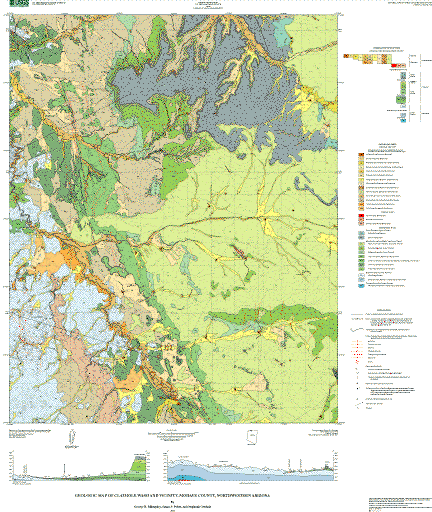
This geologic map of Clayhole Wash and vicinity covers the northern part of the Uinkaret Plateau of the Colorado Plateau geologic province of northwestern Arizona. The map is part of a cooperative U.S. Geological Survey, National Park Service, and Bureau of Land Management project to provide geologic information for areas within the Arizona Strip District of northern Arizona. This map fills in one of the remaining areas where uniform quality geologic mapping is needed. The geologic information presented will be useful for future resource management studies for federal, state, and private agencies.

How was the data set created?

  1. From what previous works were the data drawn?
  2. How were the data generated, processed, and modified?
    (process 1 of 2)
    Stable-base maps were scanned at the Flagstaff USGS Field Center on an Optronics 5040 raster scanner at a resolution of 50 microns (508 dpi). The resulting raster file was in RLE format and converted to the RLC format using the "rle2rlc" program written by Marilyn Flynn. The RLC file was subsequently converted to an ARC/INFO Grid in ARC/INFO. The linework was vectorized using Gridline. A tic file was created in latitute and longitude and projected into the base map projection (Polyconic) using a central meridian of -114.0000. Tics are defined in the four extreme corners of the map and correspond with quadrangle corners. The tic file was used to transform the grid into Universal Transverse Mercator projection. ARC/INFO generated a root mean square (RMS) report after transforming the original Grid into UTM. Scanned lines were edited interactively by hand using the ARC module ARCEDIT and a series of macros and menus, polygon regions were attributed as necessary, and all artifacts and scanning errors visible at 1:31,680 were removed.
    Date: 10-May-2002 (process 2 of 2)
    Creation of original metadata record Person who carried out this activity:
    U.S. Geological Survey
    Attn: Priest, Susan S.
    Geologist
    2255 N. Gemini Drive
    Flagstaff, AZ
    USA

    (928) 556-7148 (voice)
    (928) 556-7169 (FAX)
    spriest@usgs.gov
  3. What similar or related data should the user be aware of?
    Billingsley, George H., 2002, Geologic Map of Clayhole Wash and Vicinity, Mohave County, Northwestern, Arizona: U.S. Geological Survey Miscellaneous Field Studies Map MF-2394, U.S. Geological Survey, Flagstaff, Arizona.

    Online Links:


How reliable are the data; what problems remain in the data set?

  1. How well have the observations been checked?
    This report has undergone two scientific peer reviews, one digital database review, one review for conformity with geologic names policy, and review of the plotfiles for conformity with USGS map standards.
  2. How accurate are the geographic locations?
    Well-located data are intended to have a positional accuracy within .5 mm at a 1:31,680 map scale, or 16 meters on the ground.
  3. How accurate are the heights or depths?
  4. Where are the gaps in the data? What is missing?
    The geolgic map and digital database of Clayhole Wash is designed to describe completely the surficial and bedrock geology at a 1:31,680 scale. Geologic information only mappable at a larger scale has been omitted. All geospatial database elements are attributed.
  5. How consistent are the relationships among the observations, including topology?
    Polygon and chain-node topology present. Polygons internal to the map boundary are completely enclosed by line segments which are themselves a set of sequentially numbered coordinate pairs. Point data are represented by coordinate pairs. The neatline was mathematically generated from latitude and longitude values.

How can someone get a copy of the data set?

Are there legal restrictions on access or use of the data?
Access_Constraints: None
Use_Constraints:
Spatial resolution.
Uses of this digital geologic map should not violate the spatial resolution of the map area (1:31,680) even though the digital data form removes the constraint of scale on a paper map. The accuracy inherent in map scale is also present in digital format. At a scale larger than 1:31,680, higher resolution data is not available and will not yield greater real detail. Where this database is used in combination with other data of higher resolution, the resolution of the combined output will be limited by the lower resolution of these data.
Any hardcopies utilizing these datasets shall clearly indicate their source. If users modify the data in any way they are obligated to describe the types of modifications they have performed. User specifically agrees not to misrepresent these datasets, nor to imply that changes they made were approved by the U.S. Geological Survey.
  1. Who distributes the data set? (Distributor 1 of 1)
    U.S. Geological Survey
    Box 25286 Denver Federal Center
    Denver, CO
    USA

    1-888-ASK-USGS (voice)
    ask@usgs.gov
  2. What's the catalog number I need to order this data set?
  3. What legal disclaimers am I supposed to read?
    The U.S. Geological Survey (USGS) provides these geographic data "as is." The USGS makes no guarantee or warranty concerning the accuracy of information contained in the geographic data. The USGS further makes no warranties, either expressed or implied as to any other matter whatsoever, including, without limitation, the condition of the product, or its fitness for any particular purpose. The burden for determining fitness for use lies entirely with the user. Although these data have been processed successfully on computers at the USGS, no warranty, expressed or implied, is made by the USGS regarding the use of these data on any other system, nor does the fact of distribution constitute or imply any such warranty.
    In no event shall the USGS have any liability whatsoever for payment of any consequential, incidental, indirect, special, or tort damages of any kind, including, but not limited to, any loss of profits arising out of use of or reliance on the geographic data or arising out of delivery, installation, operation, or support by USGS.
  4. How can I download or order the data?
    • Availability in digital form:
      Data format: Multiple ARC/INFO export files, along with supporting text and pamphlets, revision list, metadata (this file), and import AML. See the pamphlet for more information about the content on the digital database. in format ARCE (version 8.1) Size: 10.6
      Network links: http://pubs.usgs.gov/mf/2002/2394/cwdb.zip
    • Cost to order the data: none


Who wrote the metadata?

Dates:
Last modified: 05-Feb-2016
Last Reviewed: 11-Feb-2003
Metadata author:
Peter N Schweitzer
USGS Midwest Area
Collection manager, USGS Geoscience Data Clearinghouse, http://geo-nsdi.er.usgs.gov/
Mail Stop 954
12201 Sunrise Valley Dr
Reston, VA
USA

703-648-6533 (voice)
703-648-6252 (FAX)
pschweitzer@usgs.gov
Metadata standard:
Content Standard for Digital Geospatial Metadata (FGDC-STD-001-1998)

This page is <https://geo-nsdi.er.usgs.gov/metadata/map-mf/2394/metadata.faq.html>
Generated by mp version 2.9.48 on Tue Jul 03 20:05:16 2018