Digital Bathymetric Model of Mono Lake, California

Metadata also available as - [Outline] - [Parseable text] - [XML]

Frequently anticipated questions:


What does this data set describe?

Title: Digital Bathymetric Model of Mono Lake, California
Abstract:
In 1986 and 1987, Pelagos Corporation of San Diego (now Racal Pelagos) undertook a bathymetric survey of Mono Lake in eastern California for the Los Angeles Department of Water and Power (DWP). The result of that survey was a series of maps at various scales and contour intervals. From these maps, the DWP hoped to predict consequences of the drop in lake level that resulted from their diversion of streams in the Mono Basin. No digital models, including shaded-relief and perspective-view renderings, were made from the data collected during the survey. With the permission of Pelagos Corporation and DWP, these data are used to produce a digital model of the floor of Mono Lake. The model was created using a geographic information system (GIS) to incorporate these data with new observations and measurements made in the field. This model should prove to be a valuable tool for enhanced visualization and analyses of the floor of Mono Lake.
  1. How might this data set be cited?
    Raumann, Christian G., Stine, Scott, Evans, Alexander, and Wilson, Jerry, 2002, Digital Bathymetric Model of Mono Lake, California: U.S. Geological Survey Miscellaneous Field Studies Map MF-2393.

    Online Links:

  2. What geographic area does the data set cover?
    West_Bounding_Coordinate: -119.155169
    East_Bounding_Coordinate: -118.901489
    North_Bounding_Coordinate: 38.079551
    South_Bounding_Coordinate: 37.937339
  3. What does it look like?
    http://pubs.usgs.gov/mf/2002/2393/mono_thumbs.jpg (JPEG)
    Reduced-size image of the map sheets, 633x260 pixels, 105k bytes.
  4. Does the data set describe conditions during a particular time period?
    Calendar_Date: 1986
    Currentness_Reference:
    ground condition
  5. What is the general form of this data set?
    Geospatial_Data_Presentation_Form: ArcInfo GRID
  6. How does the data set represent geographic features?
    1. How are geographic features stored in the data set?
      This is a Raster data set. It contains the following raster data types:
      • Dimensions 1531 x 2195 x 1, type Grid Cell
    2. What coordinate system is used to represent geographic features?
      Grid_Coordinate_System_Name: Universal Transverse Mercator
      Universal_Transverse_Mercator:
      UTM_Zone_Number: 11
      Transverse_Mercator:
      Scale_Factor_at_Central_Meridian: 0.999600
      Longitude_of_Central_Meridian: -117
      Latitude_of_Projection_Origin: 0.0
      False_Easting: 500000
      False_Northing: 0
      Planar coordinates are encoded using row and column
      Abscissae (x-coordinates) are specified to the nearest 10.0
      Ordinates (y-coordinates) are specified to the nearest 10.0
      Planar coordinates are specified in meters
      The horizontal datum used is North American Datum of 1983.
      The ellipsoid used is Geodetic Reference System 80.
      The semi-major axis of the ellipsoid used is 6378137.000000.
      The flattening of the ellipsoid used is 1/298.257222.
  7. How does the data set describe geographic features?
    Grid cell
    Estimated bathymetry of the area subtended by the cell
    elevation
    Elevation in feet above mean sea level
    Range of values
    Minimum:6228.533
    Maximum:6390.000
    Units:feet

Who produced the data set?

  1. Who are the originators of the data set? (may include formal authors, digital compilers, and editors)
    • Christian G. Raumann
    • Scott Stine
    • Alexander Evans
    • Jerry Wilson
  2. Who also contributed to the data set?
  3. To whom should users address questions about the data?
    Christian G. Raumann
    United States Geological Survey (USGS)
    Geographer
    345 Middlefield Road, Mail Stop 531
    Menlo Park, CA
    USA

    (650) 329-5648 (voice)
    (650) 329-4429 (FAX)
    craumann@usgs.gov

Why was the data set created?

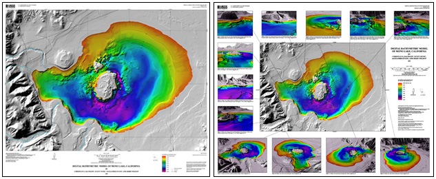
These data are intended for science researchers, students, policy makers, and the general public. The data can be used with geographic information systems (GIS) or other software to display bathymetry data of Mono Lake, California.

How was the data set created?

  1. From what previous works were the data drawn?
  2. How were the data generated, processed, and modified?
    (process 1 of 2)
    The survey data were collected along approximately 1,020 kilometers of sounding lines using two 24-foot boats, each equipped with an echo sounder, sub-bottom profiler (boomer-type system), sidescan sonar, and electronic navigation system. Water depths were measured by survey-grade echo sounders every 15 meters along each survey line, and recorded onto floppy disk along with the position data. The data was then transferred into a VAX-11/780 VMS mini-computer for editing and digitizing by a Science Accessories Model GP8 sonic digitizer. A total of 29,650 depth points were used to construct the bathymetric portion of the hard-copy topographic maps, which were then digitized and then this digital contour data was processed and the ArcInfo GRID was generated.
    Date: 10-Jun-2002 (process 2 of 2)
    Creation of original metadata record Person who carried out this activity:
    Christian G. Raumann
    United States Geological Survey
    345 Middlefield Road, Mail Stop 531
    Menlo Park, CA
    USA

    (650) 329-5648 (voice)
  3. What similar or related data should the user be aware of?

How reliable are the data; what problems remain in the data set?

  1. How well have the observations been checked?
  2. How accurate are the geographic locations?
    2.0 meters
  3. How accurate are the heights or depths?
    According to the Pelagos report, the Raytheon echo sounder used had an accuracy of 0.06 meters (0.2 feet) and their digitizing system had an accuracy of 0.08 meters (0.25 feet). Their field calibration steps were designed to meet or exceed the manufacturer's stated accuracy, bringing accuracy of depth measurements to within than 0.15 meters (0.5 feet).
    The ArcInfo GRID was generated from digitized contours of the hard-copy maps and not the actual 29,650 survey points. Therefore, the accuracy of the ArcInfo GRID relies upon the original cartography work done by Pelagos and the data processing performed thereafter.
  4. Where are the gaps in the data? What is missing?
  5. How consistent are the relationships among the observations, including topology?

How can someone get a copy of the data set?

Are there legal restrictions on access or use of the data?
Access_Constraints: None
Use_Constraints:
These data not intended for navigational purposes.
Please recognize the U.S. Geological Survey (USGS) as the source of this information. USGS-authored or produced data and information are in the public domain.
  1. Who distributes the data set? (Distributor 1 of 1)
    United States Geological Survey (USGS)
    Information Services
    Box 25286
    Denver, CO
    USA

    (888) ASK-USGS (voice)
  2. What's the catalog number I need to order this data set?
  3. What legal disclaimers am I supposed to read?
    These data not intended for navigational purposes.
    Please recognize the U.S. Geological Survey (USGS) as the source of this information. USGS-authored or produced data and information are in the public domain.
    Although these data have been used by the U.S. Geological Survey, U.S. Department of the Interior, these data and information are provided with the understanding that they are not guaranteed to be usable, timely, accurate, or complete. Users are cautioned to consider carefully the provisional nature of these data and information before using them for decisions that concern personal or public safety or the conduct of business that involves substantial monetary or operational consequences. Conclusions drawn from, or actions undertaken on the basis of, such data and information are the sole responsibility of the user.
    Neither the U.S. Government nor any agency thereof, nor any of their employees, contractors, or subcontractors, make any warranty, express or implied, nor assume any legal liability or responsibility for the accuracy, completeness, or usefulness of any data, software, information, apparatus, product, or process disclosed, nor represent that its use would not infringe on privately owned rights.
    Trade, firm, or product names and other references to non-USGS products and services are provided for information only and do not constitute endorsement or warranty, express or implied, by the USGS, USDOI, or U.S. Government, as to their suitability, content, usefulness, functioning, completeness, or accuracy.
  4. How can I download or order the data?

Who wrote the metadata?

Dates:
Last modified: 13-Jun-2016
Last Reviewed: 11-Feb-2003
Metadata author:
Peter N Schweitzer
USGS Midwest Area
Collection manager, USGS Geoscience Data Clearinghouse, http://geo-nsdi.er.usgs.gov/
Mail Stop 954
12201 Sunrise Valley Dr
Reston, VA
USA

703-648-6533 (voice)
703-648-6252 (FAX)
pschweitzer@usgs.gov
Metadata standard:
Content Standard for Digital Geospatial Metadata (FGDC-STD-001-1998)

This page is <https://geo-nsdi.er.usgs.gov/metadata/map-mf/2393/metadata.faq.html>
Generated by mp version 2.9.48 on Tue Jul 03 20:05:16 2018