Online Links:
OMGEO100.PAT:

COLUMN   ITEM NAME        WIDTH OUTPUT  TYPE N.DEC  ALTERNATE NAME
    1  AREA                   8    18     F      5
    9  PERIMETER              8    18     F      5
   17  OMGEO100#              4     5     B      -
   21  OMGEO100-ID            4     5     B      -
   25  UNIT                   4     4     I      -
   29  SOURCE                 4     4     I      -
   33  LABEL                 10    10     C      -
   43  DESC                 100   100     C      -
  143  SYMBOL                 3     3     I      -


OMGEO100.AAT:

COLUMN   ITEM NAME        WIDTH OUTPUT  TYPE N.DEC  ALTERNATE NAME
    1  FNODE#                 4     5     B      -
    5  TNODE#                 4     5     B      -
    9  LPOLY#                 4     5     B      -
   13  RPOLY#                 4     5     B      -
   17  LENGTH                 8    18     F      5
   25  OMGEO100#              4     5     B      -
   29  OMGEO100-ID            4     5     B      -
   33  LINECODE               3     3     I      -
   36  NAME                  30    30     C      -
   66  SOURCE                 4     4     I      -


OMGEO100.CON:

COLUMN   ITEM NAME        WIDTH OUTPUT  TYPE N.DEC  ALTERNATE NAME
    1  LINECODE               3     3     I      -
    4  SYMBOL                 3     3     I      -
    7  TYPE                  10    10     C      -
   17  MODIFIER              20    20     C      -
   37  CERTAINTY             15    15     C      -
   52  DESC                 100   100     C      -


OMGEO100.RU:

COLUMN   ITEM NAME        WIDTH OUTPUT  TYPE N.DEC  ALTERNATE NAME
    1  UNIT                   4     4     I      -
    5  LABEL                 10    10     C      -
   15  SYMBOL                 3     3     I      -
   18  NAME                   7     7     C      -
   25  SS                     3     3     C      -
   28  LITH                  20    20     C      -
   48  DESC                 250   250     C      -
  298  MINAGE                 7     7     C      -
  305  MAXAGE                 7     7     C      -
OMGEO100.REF:

COLUMN   ITEM NAME        WIDTH OUTPUT  TYPE N.DEC  ALTERNATE NAME
    1  SOURCE                 4     4     I      -
    5  SCALE                  8     8     I      -
   13  AUTHORS              200   200     C      -
  213  YEAR                   4     4     I      -
  217  REFERENCE            250   250     C      -
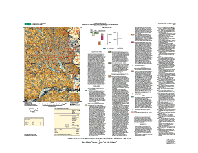
omter100 coverage: Contains geologic polygons for areas of Peoria Loess. These polygons are duplicates of ones found in omgeo100 for this unit and are used for cartographic purposes in overprinting pattern in these areas.
The INFO structure of these files is listed below:
OMTER100.PAT:

COLUMN   ITEM NAME        WIDTH OUTPUT  TYPE N.DEC  ALTERNATE NAME
    1  AREA                   8    18     F      5
    9  PERIMETER              8    18     F      5
   17  OMTER100#              4     5     B      -
   21  OMTER100-ID            4     5     B      -
   25  UNIT                   4     4     I      -
   29  SOURCE                 4     4     I      -
   33  LABEL                 10    10     C      -
   43  DESC                 100   100     C      -


OMTER100.AAT:

COLUMN   ITEM NAME        WIDTH OUTPUT  TYPE N.DEC  ALTERNATE NAME
    1  FNODE#                 4     5     B      -
    5  TNODE#                 4     5     B      -
    9  LPOLY#                 4     5     B      -
   13  RPOLY#                 4     5     B      -
   17  LENGTH                 8    18     F      5
   25  OMTER100#              4     5     B      -
   29  OMTER100-ID            4     5     B      -
   33  LINECODE               3     3     I      -
   36  NAME                  30    30     C      -
   66  SOURCE                 4     4     I      -


OMTER100.CON:

COLUMN   ITEM NAME        WIDTH OUTPUT  TYPE N.DEC  ALTERNATE NAME
    1  LINECODE               3     3     I      -
    4  SYMBOL                 3     3     I      -
    7  TYPE                  10    10     C      -
   17  MODIFIER              20    20     C      -
   37  CERTAINTY             15    15     C      -
   52  DESC                 100   100     C      -


OMTER100.REF:

COLUMN   ITEM NAME        WIDTH OUTPUT  TYPE N.DEC  ALTERNATE NAME
    1  SOURCE                 4     4     I      -
    5  SCALE                  8     8     I      -
   13  AUTHORS              200   200     C      -
  213  YEAR                   4     4     I      -
  217  REFERENCE            250   250     C      -
ompnt100 coverage: Contains geologic points for sites classified as bedrock, Loveland Loess, or Till.
The INFO structure of these files is listed below:
OMPNT100.PAT:

COLUMN   ITEM NAME        WIDTH OUTPUT  TYPE N.DEC  ALTERNATE NAME
    1  AREA                   8    18     F      5
    9  PERIMETER              8    18     F      5
   17  OMPNT100#              4     5     B      -
   21  OMPNT100-ID            4     5     B      -
   25  PTTYPE                32    32     C      -
   57  SYMBOL                 3     3     I      -
   60  SOURCE                 4     4     I      -


OMPNT100.REF:

COLUMN   ITEM NAME        WIDTH OUTPUT  TYPE N.DEC  ALTERNATE NAME
    1  SOURCE                 4     4     I      -
    5  SCALE                  8     8     I      -
   13  AUTHORS              200   200     C      -
  213  YEAR                   4     4     I      -
  217  REFERENCE            250   250     C      -
ombdy100 coverage: Contains lines defining state and county boundaries derived from USGS DLG data.
The INFO structure of these files is listed below:
OMBDY100.AAT:

COLUMN   ITEM NAME        WIDTH OUTPUT  TYPE N.DEC  ALTERNATE NAME
    1  FNODE#                 4     5     B      -
    5  TNODE#                 4     5     B      -
    9  LPOLY#                 4     5     B      -
   13  RPOLY#                 4     5     B      -
   17  LENGTH                 8    18     F      5
   25  OMBDY100#              4     5     B      -
   29  OMBDY100-ID            4     5     B      -
   33  LINECODE               3     3     I      -
   36  NAME                  30    30     C      -
   66  SOURCE                 4     4     I      -


OMBDY100.CON:

COLUMN   ITEM NAME        WIDTH OUTPUT  TYPE N.DEC  ALTERNATE NAME
    1  LINECODE               3     3     I      -
    4  SYMBOL                 3     3     I      -
    7  TYPE                  10    10     C      -
   17  MODIFIER              20    20     C      -
   37  CERTAINTY             15    15     C      -
   52  DESC                 100   100     C      -


OMBDY100.REF:

COLUMN   ITEM NAME        WIDTH OUTPUT  TYPE N.DEC  ALTERNATE NAME
    1  SOURCE                 4     4     I      -
    5  SCALE                  8     8     I      -
   13  AUTHORS              200   200     C      -
  213  YEAR                   4     4     I      -
  217  REFERENCE            250   250     C      -
omtrn100 coverage: Contains lines defining linear transportation features (highways and roads) derived from USGS DLG data.
The INFO structure of these files is listed below:
OMTRN100.AAT:

COLUMN   ITEM NAME        WIDTH OUTPUT  TYPE N.DEC  ALTERNATE NAME
    1  FNODE#                 4     5     B      -
    5  TNODE#                 4     5     B      -
    9  LPOLY#                 4     5     B      -
   13  RPOLY#                 4     5     B      -
   17  LENGTH                 8    18     F      5
   25  OMTRN100#              4     5     B      -
   29  OMTRN100-ID            4     5     B      -
   33  ENTITY_LABEL           7     7     C      -
   40  ROUTE_NUMBER1          7     7     C      -


OMTRN100.REF:


COLUMN   ITEM NAME        WIDTH OUTPUT  TYPE N.DEC  ALTERNATE NAME
    1  SOURCE                 4     4     I      -
    5  SCALE                  8     8     I      -
   13  AUTHORS              200   200     C      -
  213  YEAR                   4     4     I      -
  217  REFERENCE            250   250     C      -
omhyp100 coverage: Contains lines defining hypsographic features derived from USGS DLG data. The ELEVATION_M item stores the 20 meter contour elevation data. The ENTITY_ LABEL item stores the DLG major/minor 0200200 code common to all arcs in the dataset, which identifies the type of hypsographic data.
The INFO structure of these files is listed below:
OMHYP100.AAT:

COLUMN   ITEM NAME        WIDTH OUTPUT  TYPE N.DEC  ALTERNATE NAME
    1  FNODE#                 4     5     B      -
    5  TNODE#                 4     5     B      -
    9  LPOLY#                 4     5     B      -
   13  RPOLY#                 4     5     B      -
   17  LENGTH                 8    18     F      5
   25  OMHYP100#              4     5     B      -
   29  OMHYP100-ID            4     5     B      -
   33  ENTITY_LABEL           7     7     C      -
   40  ELEVATION_M            8    12     F      3


OMHYP100.REF:


COLUMN   ITEM NAME        WIDTH OUTPUT  TYPE N.DEC  ALTERNATE NAME
    1  SOURCE                 4     4     I      -
    5  SCALE                  8     8     I      -
   13  AUTHORS              200   200     C      -
  213  YEAR                   4     4     I      -
  217  REFERENCE            250   250     C      -
omhyd100 coverage: Contains polygons and lines defining hydrographic features derived from USGS DLG data. The ENTITY_LABEL item defines major streams/rivers/lakes (polygons) as open water fill areas when coded 0500200.
The INFO structure of these files is listed below:
OMHYD100.PAT:

COLUMN   ITEM NAME        WIDTH OUTPUT  TYPE N.DEC  ALTERNATE NAME
    1  AREA                   8    18     F      5
    9  PERIMETER              8    18     F      5
   17  OMHYD100#              4     5     B      -
   21  OMHYD100-ID            4     5     B      -
   25  ENTITY_LABEL           7     7     C      -
   32  SOURCE                 4     4     I      -


OMHYD100.AAT:

COLUMN   ITEM NAME        WIDTH OUTPUT  TYPE N.DEC  ALTERNATE NAME
    1  FNODE#                 4     5     B      -
    5  TNODE#                 4     5     B      -
    9  LPOLY#                 4     5     B      -
   13  RPOLY#                 4     5     B      -
   17  LENGTH                 8    18     F      5
   25  OMHYD100#              4     5     B      -
   29  OMHYD100-ID            4     5     B      -
   33  SOURCE                 4     4     I      -


OMHYD100.REF:


COLUMN   ITEM NAME        WIDTH OUTPUT  TYPE N.DEC  ALTERNATE NAME
    1  SOURCE                 4     4     I      -
    5  SCALE                  8     8     I      -
   13  AUTHORS              200   200     C      -
  213  YEAR                   4     4     I      -
  217  REFERENCE            250   250     C      -
ommea100 coverage: Contains lines defining scarps bordering former channels of the Missouri River. Hatchures point downslope.
The INFO structure of these files is listed below:
OMMEA100.AAT:

COLUMN   ITEM NAME        WIDTH OUTPUT  TYPE N.DEC  ALTERNATE NAME
    1  FNODE#                 4     5     B      -
    5  TNODE#                 4     5     B      -
    9  LPOLY#                 4     5     B      -
   13  RPOLY#                 4     5     B      -
   17  LENGTH                 4    12     F      3
   21  OMMEA100#              4     5     B      -
   25  OMMEA100-ID            4     5     B      -
   29  LINECODE               3     3     I      -
   32  NAME                  30    30     C      -
   62  SOURCE                 4     4     I      -


OMMEA100.STR:

COLUMN   ITEM NAME        WIDTH OUTPUT  TYPE N.DEC  ALTERNATE NAME
    1  LINECODE               3     3     I      -
    4  SYMBOL                 3     3     I      -
    7  TYPE                  10    10     C      -
   17  HORIZONTAL            20    20     C      -
   37  VERTICAL              20    20     C      -
   57  FOLD                  15    15     C      -
   72  PLUNGE                15    15     C      -
   87  ACCURACY              15    15     C      -
  102  CERTAINTY             15    15     C      -
  117  DESC                 100   100     C      -


OMMEA100.REF:

COLUMN   ITEM NAME        WIDTH OUTPUT  TYPE N.DEC  ALTERNATE NAME
    1  SOURCE                 4     4     I      -
    5  SCALE                  8     8     I      -
   13  AUTHORS              200   200     C      -
  213  YEAR                   4     4     I      -
  217  REFERENCE            250   250     C      -
Auxiliary files:
UNIT  | LABEL | DESC
1     | af    | Artificial fill deposits
2     | Qal   | Flood plain and stream channel alluvium
3     | Qsw   | Sheetwash alluvium
4     | Qss   | Sheetwash and stream alluvium
5     | Qlp   | Peoria Loess
6     | Qll   | Loveland Loess
7     | Qti   | Till
8     | R     | Bedrock
9     | w     | Open Water
Coding of ENTITY_LABEL attribute numbers in the omtrn100 coverage is listed below:
Interstates
1700201
1700203
Minor highways
1700204
1700205
Main roads
1700209
Minor streets
1700210
1700211
Main road on/off ramps
1700402
Shroba's knowledge of the surficial geology in the greater Omaha area was enhanced by informative discussions with Vincent Dreezen, Duane Eversoll, Joseph Mason, Vernon Souders, and Scott Summerside of the Nebraska Conservation and Survey Division. Earlier versions of this map were prepared with digital assistance provided from Maria Furey of the U.S. Geological Survey. This report was improved greatly by helpful reviews by Joseph Mason of the Nebraska Conservation and Survey Division and David Fullerton of the U.S. Geological Survey. Paco Van Sistine, Townsend Management Services, initially processed existing USGS Digital Line Graph data for transportation, hypsography, and hydrography themes used in this map.
This map provides geologic information for land-use decisions.
Are there legal restrictions on access or use of the data?Access_Constraints: none
Use_Constraints:none. Acknowledgment of the U.S. Geological Survey would be appreciated in products derived from these data. Although software enables the user to display images at various scales, map data in this report should not be used at scales greater than 1:100,000.
Although this digital spatial data has been subjected to rigorous review and is substantially complete, it is released on the condition that neither the USGS nor the United States Government nor any agency thereof, nor any employees thereof, make any warranty, expressed or implied, or assumes any legal liability or responsibility for the accuracy, completeness, or usefulness of any information, apparatus, product, or process disclosed in this report, or represents that its use would not infringe privately owned rights. Reference therein to any specific commercial product, process, or service by trade name, trademark, manufacturer, or otherwise does not necessarily constitute or imply its endorsement, recommendation, or favoring by the United States Government or any agency thereof. Any views and opinions of authors expressed herein do not necessarily state or reflect those of the United States Government or any agency thereof.
| Data format: | Geologic units and structural features in format ARCE (version 7.1.2) Size: 90 |
|---|---|
| Network links: |
http://pubs.usgs.gov/mf/2001/mf-2391/mf-2391.tar.gz |
| Data format: | Geologic units and structural features in format Shapefile (version 1.0) Size: 90 |
|---|---|
| Network links: |
http://pubs.usgs.gov/mf/2001/mf-2391/mf-2391.tar.gz |