Geologic map of the Dillon quadrangle, Summit and Grand Counties, Colorado

Metadata also available as - [Outline] - [Parseable text] - [XML]

Frequently anticipated questions:


What does this data set describe?

Title:
Geologic map of the Dillon quadrangle, Summit and Grand Counties, Colorado
Abstract:
New 1:24,000-scale geologic mapping along the Interstate-70 urban corridor in western Colorado, in support of the USGS Central Region State/USGS Cooperative Geologic Mapping Project, is contributing to a more complete understanding of the stratigraphy, structure, tectonic evolution, and hazard potential of this rapidly developing region. The 1:24,000-scale Dillon quadrangle is near the headwaters of the Blue River and straddles features of the Blue River graben (Kellogg, 1999), part of the northernmost reaches of the Rio Grande rift, a major late Oligocene to recent zone of extension that extends from Colorado to Mexico. The Williams Range thrust fault, the western structural margin of the Colorado Front Range, cuts through the center of the quadrangle, although is mostly covered by surficial deposits.
The oldest rocks in the quadrangle underlie the Williams Fork Mountains and the ridge immediately east of South Fork Middle Fork River, and include biotite-sillimanite schist and gneiss, amphibolite, and migmatite that are intruded by granite inferred to be part of the 1,667-1,750 Ma Routt Plutonic Suite (Tweto, 1987). The oldest exposed sedimentary unit is the Upper Jurassic Morrison Formation, but Pennsylvanian Maroon Formation, a sequence of red sandstone, conglomerate, and interbedded shale, underlies the southern part of the quadrangle. The thickest sequence of sedimentary rocks is Cretaceous in age and includes at least 500 m of the Upper Cretaceous Pierre Shale. Surficial deposits include (1) an old, deeply dissected landslide deposit, possibly as old as Pliocene, on the west flank of the Williams Fork Mountains, (2) deeply weathered, very coarse gravel deposits underlying a mesa in the southwest part of the quadrangle (the Mesa Cortina subdivision. The gravels are gold bearing and were mined by hydraulic methods in the 1800s), (3) moderately to deeply weathered, widespread, bouldery material that is a combination of till of the Bull Lake glaciation, debris-flow deposits, landslide deposits, and possibly pre-Bull Lake till, (4) glacial deposits of both Bull Lake (middle Pleistocene) and Pinedale (late Pleistocene)glaciations, (5) recent landslide deposits, and (6)extensive colluvial and alluvial deposits.
  1. How might this data set be cited?
    Kellogg, Karl S., 2002, Geologic map of the Dillon quadrangle, Summit and Grand Counties, Colorado: Miscellaneous Field Studies Map MF-2390, U.S. Geological Survey, Denver, Colorado.

    Online Links:

  2. What geographic area does the data set cover?
    West_Bounding_Coordinate: -106.125
    East_Bounding_Coordinate: -106.0
    North_Bounding_Coordinate: 39.750
    South_Bounding_Coordinate: 39.625
  3. What does it look like?
    http://pubs.usgs.gov/mf/2002/mf-2390/mf-2390.gif (GIF)
    Reduced-size image of the map sheet, 288x305 pixels, 44k bytes.
    http://pubs.usgs.gov/mf/2002/mf-2390/downloads/mf-2390.pdf (PDF)
    Printable representation of map layout, 5.3 MB.
  4. Does the data set describe conditions during a particular time period?
    Calendar_Date: 2002
    Currentness_Reference:
    publication date
  5. What is the general form of this data set?
    Geospatial_Data_Presentation_Form: map
  6. How does the data set represent geographic features?
    1. How are geographic features stored in the data set?
      This is a Vector data set.
    2. What coordinate system is used to represent geographic features?
      The map projection used is Polyconic.
      Projection parameters:
      Longitude_of_Central_Meridian: -105.5
      Latitude_of_Projection_Origin: 0.0
      False_Easting: 0.000
      False_Northing: 0.000
      Planar coordinates are encoded using coordinate pair
      Abscissae (x-coordinates) are specified to the nearest 20
      Ordinates (y-coordinates) are specified to the nearest 20
      Planar coordinates are specified in METERS
      The horizontal datum used is North American Datum of 1927.
      The ellipsoid used is Clarke 1866.
      The semi-major axis of the ellipsoid used is 6378206.4.
      The flattening of the ellipsoid used is 1/294.98.
  7. How does the data set describe geographic features?
    Entity_and_Attribute_Overview:
    ---------------------------------------------------------------
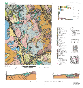
    COVERAGE NAME: dillonpoly
    ---------------------------------------------------------------
    
    USER-DEFINED ITEMS IN DILLONPOLY.PAT:
    ------------------------------------
    
    ATTRIBUTE NAME: DESCRIPTION
    DATABASE ITEM STRUCTURE: 80,80,C,0
    DESCRIPTION: Short textual description of the map unit. Complete
      descriptions of the map units are normally provided in an accompanying
      report. This description is typically shown on the legend printed on the
      map sheet.
    ATTRIBUTE NAME: LABEL
    DATABASE ITEM STRUCTURE: 6,6,C,0
    DESCRIPTION: Map unit label.
    
    ATTRIBUTE NAME: SYMBOL
    DATABASE ITEM STRUCTURE: 4,4,I,0
    DESCRIPTION: Integer index of the proper color for this polygon.  The index
      indicates which element of the shade set color524.shd is used.
    
    CORRELATION OF ITEMS SYMBOL, LABEL, AND DESCRIPTION IN DILLONPOLY.PAT:
    
    SYMBOL   LABEL  DESCRIPTION
    0               water
    2        Qal    alluvium
    12       Qcl    colluvium and loess, undivided
    16       Qls    younger landslide deposits
    23       Qg     terrace gravel
    25       Qac    alluvium and colluvium, undivided
    26       Qt     talus
    29       Xdi    diorite and quartz diorite
    32       Qf     fan deposits
    35       Qop    Pinedale outwash gravel
    35       Qop?   Pinedale outwash gravel, uncertain
    64       Xgr    granodiorite and quartz monzonite
    75       Xbg    biotite gneiss
    88       YXggp  granitic rocks, biotite gneiss, and pegmatite
    98       QTgm   gravel of Mesa Cortina
    102      Xsg    biotite-muscovite-sillimanite gneiss and schist
    112      Qtb    Bull Lake till
    115      Qtp    Pinedale till
    150      YXpg   pegmatite and granite complex
    156      YXp    pegmatite
    222      Xqz    quartzite
    334      Xam    amphibolite
    367      Kpm    Pierre Shale, shale and sandstone member
    371      Kb     Benton Shale
    411      Kps    Pierre Shale, sandstone member
    416      Kp     Pierre Shale, undivided
    417      Kpl    Pierre Shale, lower shale member
    427      Jm     Morrison Formation
    440      Kn     Niobrara Formation
    444      QTd    diamicton
    449      QTls   older landslide deposits
    454      Kd     Dakota Sandstone
    455      Qgo    older outwash gravel
    456      Qr     rock-glacier deposits
    468      Xkbg   microcline-biotite gneiss
    496      Qdf    debris-flow deposit
    504      Xbmg   biotite-muscovite gneiss and schist
    514      af     artificial fill
    520      Xmg    migmatite
    
    USER-DEFINED ITEMS IN DILLONPOLY.AAT:
    ------------------------------------
    
    ATTRIBUTE NAME: DESCRIPTION
    DATABASE ITEM STRUCTURE: 80,80,C,0
    DESCRIPTION: Text indicating the type of linear geologic feature.
    
    ATTRIBUTE NAME: SYMBOL
    DATABASE ITEM STRUCTURE: 3,3,I,0
    DESCRIPTION: Integer index of the line type used for plotting the feature
      on the map.  The symbol set used to plot these features is geol_sfo.lin.
    
    CORRELATION OF ITEMS SYMBOL AND DESCRIPTION IN DILLONPOLY.AAT:
    
    SYMBOL   DESCRIPTION
    0        water boundary
    1        contact
    2        contact, approximately located
    4        contact, concealed
    14       thrust fault
    20       thrust fault, approximately located
    24       thrust fault, concealed
    50       normal fault
    173      map boundary
    176      fault, concealed
    176      normal fault, concealed
    183      normal fault, approximately located
    184      normal fault, concealed
    216      fault, approximately located
    227      fault
    
    ---------------------------------------------------------------
    COVERAGE NAME: dillonline
    ---------------------------------------------------------------
    
    USER-DEFINED ITEMS IN DILLONLINE.AAT:
    ------------------------------------
    
    ATTRIBUTE NAME: DESCRIPTION
    DATABASE ITEM STRUCTURE: 80,80,C,0
    DESCRIPTION: Text indicating the type of linear geologic feature.
    
    ATTRIBUTE NAME: SYMBOL
    DATABASE ITEM STRUCTURE: 3,3,I,0
    DESCRIPTION: Integer index of the line type used for plotting the feature
      on the map.  The line type is given by the symbol set (whose
      name is specified in an accompanying attribute) and this
      index value.
    
    ATTRIBUTE NAME: SYMSET
    DATABASE ITEM STRUCTURE: 20,20,C,0
    DESCRIPTION: Name of the symbol set containing the appropriate line
      style to be used for plotting this feature.  Text.
    
    CORRELATION OF ITEMS SYMBOL, SYMSET, AND DESCRIPTION IN DILLONLINE.AAT:
    
    SYMBOL  SYMSET         DESCRIPTION
    11      geoscamp1.lin  scarp
    15      geoscamp1.lin  sackung structure
    60      geol_sfo.lin   anticline
    63      geol_sfo.lin   anticline, concealed
    92      geol_sfo.lin   plunging syncline
    92      geol_sfo.lin   syncline
    95      geol_sfo.lin   plunging syncline, concealed
    95      geol_sfo.lin   syncline, concealed
    173     geol_sfo.lin   cross-section line A-A'
    173     geol_sfo.lin   cross-section line B-B'
    
    ---------------------------------------------------------------
    COVERAGE NAME: dillonpoint
    ---------------------------------------------------------------
    
    USER-DEFINED ITEMS IN DILLONPOINT.PAT:
    ------------------------------------
    
    ATTRIBUTE NAME: DESCRIPTION
    DATABASE ITEM STRUCTURE: 80,80,C,0
    DESCRIPTION: Text indicating the type of geologic point feature.
    
    ATTRIBUTE NAME: AZIMUTH
    DATABASE ITEM STRUCTURE: 7,7,I,0
    DESCRIPTION: Integer value in the range 0-359 indicating rotation of the
      point feature in the horizontal plane. In the case of bedding or jointing,
      this value indicates the strike.
    
    ATTRIBUTE NAME: INCLINATION
    DATABASE ITEM STRUCTURE: 5,5,I,0
    DESCRIPTION: Integer value in the range 0-90 indicating the inclination from
      horizontal of the point feature. In the case of bedding or jointing,
      this value indicates the dip.
    
    ATTRIBUTE NAME: SYMBOL
    DATABASE ITEM STRUCTURE: 3,3,I,0
    DESCRIPTION: Integer index of the point type used for plotting the feature
      on the map.  The point type is given by the symbol set (whose
      name is specified in an accompanying attribute) and this
      index value.
    
    ATTRIBUTE NAME: SYMSET
    DATABASE ITEM STRUCTURE: 20,20,C,0
    DESCRIPTION: Name of the symbol set containing the appropriate symbol
      to be used for plotting this feature.  Text.
    
    CORRELATION OF ITEMS SYMBOL, SYMSET, AND DESCRIPTION IN DILLONPOINT.PAT:
    
    SYMBOL  SYMSET          DESCRIPTION
    2       geoscamp2.mrk   strike and dip of inclined beds
    53      plotter.mrk     sample locality for zircon age dating
    81      geoscamp2.mrk   strike and dip of foliation
    82      geoscamp2.mrk   vertical foliation
    122     usgs.mrk        gravel pit
    130     geoscamp2.mrk   bearing and plunge of lineation
    
    Entity_and_Attribute_Detail_Citation:

Who produced the data set?

  1. Who are the originators of the data set? (may include formal authors, digital compilers, and editors)
    • Karl S. Kellogg
  2. Who also contributed to the data set?
    A.M. Licamelli, R.G. Kuehn, K.S. Morgan contributed to the compilation of this map.
  3. To whom should users address questions about the data?

Why was the data set created?

To update and reinterpret earlier geologic mapping, and to achieve a uniform regional geologic database.

How was the data set created?

  1. From what previous works were the data drawn?
  2. How were the data generated, processed, and modified?
    Date: 1996 (process 1 of 10)
    Field geologic mapping
    Date: 1999 (process 2 of 10)
    Polygons, lines, and points representing geologic features and data points were digitized from scale-stable compilation materials using the GSMCAD public domain program (USGS Open-File Report 96-007).
    Date: 1999 (process 3 of 10)
    The map data were exported to ARC/INFO using the GSMCAD export function to create ARC generate ASCII files. The ASCII files were then imported into ArcInfo using the GENERATE routine, and polygon topology built.
    Date: 1999 (process 4 of 10)
    The gsmdraw.aml program was used in ARC to produce a graphics file of the colored map. In addition an explanation sheet was produced that includes a correlation of map units diagram, a list of map unit names and corresponding symbols, and an explanation of graphical map symbols.
    Date: 2000 (process 5 of 10)
    Text map unit descriptors were added to the .AAT and .PAT database files for each coverage.
    Date: 2000 (process 6 of 10)
    Draft check plots of the geologic map and explanation were created and submitted for peer review. Geologists reviewed the plots for conformity with U.S. Geological Survey editorial standards and stratigraphic nomenclature. Revisions were made to the geospatial database as needed.
    Date: 2000 (process 7 of 10)
    The database files, metadata, and check plots were edited by the USGS Central Publications Group, and revisions made to the geospatial database as needed.
    Date: 2000 (process 8 of 10)
    The geospatial database files and metadata were quality checked for completeness and consistency.
    Date: 2000 (process 9 of 10)
    Final preparation of the geospatial database for distribution, and preparation of map-on-demand files and metadata.
    Date: 08-Jun-2009 (process 10 of 10)
    Creation of original metadata record Person who carried out this activity:
    Karl Kellogg
    U.S. Geological Survey, CR
    Mail Stop 913
    Box 25046, Denver Federal Center
    Denver, CO
    USA

    303-236-1305 (voice)
    303-236-0214 (FAX)
    kkellogg@usgs.gov
  3. What similar or related data should the user be aware of?

How reliable are the data; what problems remain in the data set?

  1. How well have the observations been checked?
    Data was entered and checked by the geologist who made the observations. The attributes of this geospatial data set consist of text identifiers and numeric codes that indicate the identity of the geologic unit or type of geologic feature, and determine how each feature is colored or symbolized. To check attribute accuracy, a color check plot was visually compared to the geologist's original compilation. Discrepancies between the digital geospatial dataset and the original analog compilation were corrected as needed. Machine-created listings of unique attribute values were used to identify spelling errors or other inconsistencies, and corrections were made as needed. This map was thoroughly reviewed for conformity with U.S. Geological Survey editorial standards and stratigraphic nomenclature.
  2. How accurate are the geographic locations?
    Lines were primarily mapped by ground investigation and photointerpretation of 1:24,000-scale color aerial photographs. These lines were digitized from the topographic field sheets and from annotated aerial photographs. Most digitized positions on the map are estimated to have about 20 m horizontal accuracy. Additional point observations were added using positions determined by a Rockwell PLGR-96 GPS unit with horizontal accuracy of about 10 meters. There is no elevation data in the database.
  3. How accurate are the heights or depths?
  4. Where are the gaps in the data? What is missing?
    Data is complete: no features were eliminated or generalized. Unit properties are described in the text explanation.
  5. How consistent are the relationships among the observations, including topology?
    Map elements were visually checked by the author for overshoots, undershoots, duplicate features, polygon attributes, and other errors. Automated (ARC/INFO) routines were also used to check the databases for polygon label errors, line or point attribution errors, sliver polygons, dangling arcs, intersection errors, and projection information. The map was reviewed by two other geologists for consistency with basic geologic principles and general conformity to USGS mapping standards.

How can someone get a copy of the data set?

Are there legal restrictions on access or use of the data?
Access_Constraints: none
Use_Constraints:
none. Acknowledgment of the U.S. Geological Survey would be appreciated in products derived from these data.
  1. Who distributes the data set? (Distributor 1 of 1)
    U.S. Geological Survey Central Publications Group
    MS 902, Box 25046 DFC
    Lakewood, CO

    303-236-5486 (voice)
  2. What's the catalog number I need to order this data set? USGS Miscellaneous Field Studies Map MF-2390
  3. What legal disclaimers am I supposed to read?
    Although this digital spatial data has been subjected to rigorous review and is substantially complete, it is released on the condition that neither the USGS nor the United States Government may be held liable for any damages resulting from its authorized or unauthorized use.
  4. How can I download or order the data?

Who wrote the metadata?

Dates:
Last modified: 05-Feb-2016
Metadata author:
Peter N Schweitzer
USGS Midwest Area
Collection manager, USGS Geoscience Data Clearinghouse, http://geo-nsdi.er.usgs.gov/
Mail Stop 954
12201 Sunrise Valley Dr
Reston, VA
USA

703-648-6533 (voice)
703-648-6252 (FAX)
pschweitzer@usgs.gov
Metadata standard:
Content Standard for Digital Geospatial Metadata (FGDC-STD-001-1998)
Metadata extensions used:

This page is <https://geo-nsdi.er.usgs.gov/metadata/map-mf/2390/metadata.faq.html>
Generated by mp version 2.9.48 on Tue Jul 03 20:05:14 2018