Online Links:
| Value | Definition |
|---|---|
| 7 | unanalyzed |
| 8 | water |
| Range of values | |
|---|---|
| Minimum: | 1 |
| Maximum: | 6 |
The authors would like to thank Russ Graymer, Steve Walter and Scott Graham for technical assistance during the map construction. We would also like to thank Ray Wilson and Kevin Schmidt for reviews of the map and manuscript.
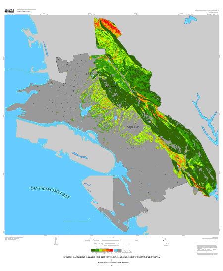
The map is intended as a tool for regional planning. Any site- specific planning or analysis should be undertaken with the assistance of a qualified geotechnical engineer. This hazard map should not be used as a substitute to the State of California Seismic Hazard Zones map for the same area. (See California Department of Conservation, Division of Mines and Geology, 1999). As previously noted for maps of this type by Wieczorek and others (1985), this map should not be used as a basis to determine the absolute risk from seismically triggered landslides at any locality, as the sole justification for zoning or rezoning and parcel, for detailed design of any lifeline, for site- specific hazard-reduction planning, or for setting or modifying insurance rates.
Online Links:
Are there legal restrictions on access or use of the data?Access_Constraints: None
Use_Constraints:Users should acknowledge the authors and the U.S. Geological Survey if data used to derive products. Users should check with the western publications website prior to use to check for revisions or updates.
The map is intended as a tool for regional planning. Any site- specific planning or analysis should be undertaken with the assistance of a qualified geotechnical engineer. This hazard map should not be used as a substitute to the State of California Seismic Hazard Zones map for the same area. (See California Department of Conservation, Division of Mines and Geology, 1999). As previously noted for maps of this type by Wieczorek and others ( 1985), this map should not be used as a basis to determine the absolute risk from seismically triggered landslides at any locality, as the sole justification for zoning or rezoning any parcel, for detailed design of any lifeline, for site-specific hazard-reduction planning, or for setting or modifying insurance rates.
Although these data have been processed successfully on a computer system at the U.S. Geological Survey, no warranty expressed or implied is made by the U.S. Geological Survey regarding the utility of the data on any other system, nor shall the act of distribution constitute any such warranty. No responsibility is assumed by the U.S. Geological Survey in the use of these data. Any use of trade, product, or firm names is for descriptive purposes only and does not imply endorsement by the U.S. Government.
| Data format: | Grid with ancillary vector coverages depicting base map information. in format ARCE (version 8.0) Size: 1.7 |
|---|---|
| Network links: |
http://pubs.usgs.gov/mf/2001/2379/oakdb.zip |