Citation:
Citation_Information:
Originator: William H. Langer
Originator: David Smith
Originator: Lawrence L. Brady
Originator: Roger A. Melick
Originator: Daniel H. Knepper, Jr.
Publication_Date: 2002
Title: Geologic map of the Saint Joseph area, Missouri and Kansas
Edition: 1.0
Geospatial_Data_Presentation_Form: map
Series_Information:
Series_Name: U.S. Geological Survey Miscellaneous Field Studies Map
Issue_Identification: MF-2374
Publication_Information:
Publication_Place: Denver, Colorado
Publisher: U.S. Geological Survey
Online_Linkage: http://pubs.usgs.gov/mf/2002/mf-2374/
Description:
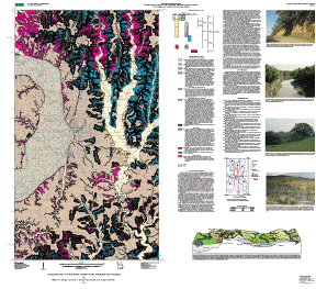
Abstract:
The map shows the surficial geology, including alluvium, loess, till,
terrace alluvium, eolian silt, glaciofluvial gravel, and bedrock
outcrops in the area around St. Joseph, Missouri.
Purpose:
To describe the surficial geology in the area around St. Joseph, Missouri.
Time_Period_of_Content:
Time_Period_Information:
Single_Date/Time:
Calendar_Date: 2002
Currentness_Reference: publication date
Status:
Progress: Complete
Maintenance_and_Update_Frequency: As needed
Spatial_Domain:
Bounding_Coordinates:
West_Bounding_Coordinate: -95.00
East_Bounding_Coordinate: -94.625
North_Bounding_Coordinate: 40.00
South_Bounding_Coordinate: 39.5
Keywords:
Theme:
Theme_Keyword_Thesaurus: USGS Thesaurus
Theme_Keyword: geology
Theme_Keyword: geologic maps
Theme_Keyword: surficial geologic units
Theme_Keyword: unconsolidated deposits
Theme_Keyword: geospatial datasets
Theme_Keyword: Quaternary
Theme:
Theme_Keyword_Thesaurus: American Geological Institute (AGI) Glossary of Geology
Theme_Keyword: loess
Theme_Keyword: till
Theme_Keyword: pre-Illinoian A2
Theme_Keyword: Nebraskan
Theme_Keyword: Kansan
Theme_Keyword: pre-Illinoian A1
Theme_Keyword: Loveland Loess
Theme_Keyword: Peoria Loess
Theme_Keyword: Bignell Loess
Theme:
Theme_Keyword_Thesaurus: ISO 19115 Topic Categories
Theme_Keyword: geoscientificInformation
Place:
Place_Keyword_Thesaurus: none
Place_Keyword: USA
Place_Keyword: Missouri
Place_Keyword: Kansas
Place_Keyword: Missouri River
Place_Keyword: Saint Joseph
Place:
Place_Keyword_Thesaurus: Augmented FIPS 10-4 and FIPS 6-4
Place_Keyword: f20043 = Doniphan
Place_Keyword: f29003 = Andrew
Place_Keyword: f29021 = Buchanan
Place_Keyword: f29165 = Platte
Access_Constraints: none
Use_Constraints:
This database is not meant to be used or displayed at scales larger
or smaller than the range encompassing 1:50,000 to 1:63,360.
Point_of_Contact:
Contact_Information:
Contact_Person_Primary:
Contact_Person: William H Langer
Contact_Organization: U.S. Geological Survey Central Region Minerals Team
Contact_Position: Research Geologist
Contact_Address:
Address_Type: mailing address
Address:
Mail Stop 973
P.O. Box 25046
City: Denver
State_or_Province: CO
Postal_Code: 80225
Country: USA
Contact_Voice_Telephone: 303-236-1249
Contact_Facsimile_Telephone: 303-236-3200
Contact_Electronic_Mail_Address: blanger@usgs.gov
Browse_Graphic:
Browse_Graphic:
Data_Set_Credit:
This map was prepared as a collaborative effort with the Missouri
Division of Geology and Land Survey, the Kansas Geological Survey, and
the Nebraska Conservation and Survey Division.
William H. Langer and David Smith mapped the geology in 1993 and
1994. The authors' team digitized the map and prepared the ARC/INFO
database. Database structure checked by Nancy Shock, and she
prepared the files for importing into Adobe Illustrator. Norma J.
Maes prepared the Adobe Illustrator map layout, which was used for
the on-demand paper map and gif and pdf plot and browse graphic
files. F.C. Brunstein edited the publication and prepared some of
the files for the Illustrator layout, and prepared the metadata
file, which was checked by Nancy Shock.
Native_Data_Set_Environment: ARC/INFO version 7.1.2