Geologic map of the Silver Lake quadrangle, Cowlitz County, Washington

Metadata also available as - [Outline] - [Parseable text] - [XML]

Frequently anticipated questions:


What does this data set describe?

Title:
Geologic map of the Silver Lake quadrangle, Cowlitz County, Washington
Abstract:
This digital map database, compiled from previously published and unpublished data, and new mapping by the authors, represents the general distribution of bedrock and surficial deposits of the Silver lake 7.5 minute quadrangle. The database delineates map units that are identified by general age and lithology following the stratigraphic nomenclature of the U.S. Geological Survey. The scale of the source maps limits the spatial resolution (scale) of the database to 1:24,000 or smaller.
  1. How might this data set be cited?
    Evarts, Russell C., 2001, Geologic map of the Silver Lake quadrangle, Cowlitz County, Washington: U.S. Geological Survey Miscellaneous Field Studies Map MF-2371.

    Online Links:

  2. What geographic area does the data set cover?
    West_Bounding_Coordinate: -122.875284
    East_Bounding_Coordinate: -122.749430
    North_Bounding_Coordinate: 46.374998
    South_Bounding_Coordinate: 46.250002
  3. What does it look like?
    http://pubs.usgs.gov/mf/2001/2371/images/slake.gif (GIF)
    Reduced-size image of the entire map sheet, 450x379 pixels, 24-bit color, 48k bytes.
  4. Does the data set describe conditions during a particular time period?
    Calendar_Date: 2001
    Currentness_Reference:
    Publication date
  5. What is the general form of this data set?
    Geospatial_Data_Presentation_Form: vector digital data
  6. How does the data set represent geographic features?
    1. How are geographic features stored in the data set?
      This is a Vector data set. It contains the following vector data types (SDTS terminology):
      • Complete chain
      • Entity point
      • GT-polygon composed of chains
      • Point
    2. What coordinate system is used to represent geographic features?
      The map projection used is Transverse Mercator.
      Projection parameters:
      Scale_Factor_at_Central_Meridian: 0.9996
      Longitude_of_Central_Meridian: -123.0
      Latitude_of_Projection_Origin: 0.0
      False_Easting: 500000
      False_Northing: 0.0
      Planar coordinates are encoded using coordinate pair
      Abscissae (x-coordinates) are specified to the nearest 0.000032
      Ordinates (y-coordinates) are specified to the nearest 0.000032
      Planar coordinates are specified in meters
      The horizontal datum used is North American Datum 1927.
      The ellipsoid used is Clarke 1866.
      The semi-major axis of the ellipsoid used is 6378206.4.
      The flattening of the ellipsoid used is 1/294.98.
  7. How does the data set describe geographic features?
    sl_geo.pat
    Geologic units and other polygonal features
    PTYPE
    Geologic unit designation
    ValueDefinition
    QaAlluvium (Holocene)
    QfCataclysmic flood deposits (Holocene)
    QlLake deposits (Holocene)
    QlhLogan Hill Formation (Pleistocene)
    QlsLandslide deposits (Holocene and Pleistocene)
    QoaOlder alluvium (Holocene)
    QsaDeposits of Ape Canyon eruptive stage (Pleistocene)
    QslDeposits of 1980 lahars (Holocene)
    QspDeposits of Pine Creek eruptive period of the Spirit Lake eruptive stage (Holocene)
    QssDeposits of Swift Creek eruptive stage (Pleistocene)
    Qss?Questionable deposits of Swift Creek eruptive stage (Pleistocene)
    QtTalus deposits (Holocene and Pleistocene)
    TaAndesite (Eocene)
    TahgAndesite of Hollywood Gorge (Eocene)
    TbaBasaltic andesite (Eocene)
    TcCowlitz Formation (Eocene)
    TdiDiorite (Eocene or Oligocene)
    TgrsGrande Ronde Basalt, member of Sentinel Bluffs (Miocene)
    TkBasalt of Kalama River (Eocene)
    TmtMafic tuff (Eocene)
    TtoToutle Formation (Eocene)
    TtobBasaltic andesite flows
    TtocCline Creek Tuff Member
    TtsPumice-lapilli tuff of Sucker Creek (Eocene)
    TvsVolcaniclastic sedimentary rocks (Eocene)
    TwWilkes Formation (Miocene and Pliocene?)
    TwpBasalt of Wolf Point (Eocene)
    waterpresent-day lakes
    sl_geo.aat
    Linear geological features
    LTYPE
    Type of linear geologic feature
    ValueDefinition
    contact, approx. located 
    contact, certain 
    contact, concealed 
    contact, inferred 
    map boundary 
    normal fault, approx. located 
    normal fault, approx. located _m 
    normal fault, certain 
    normal fault, certain _m 
    normal fault, concealed 
    s.s. fault, r.l., approx. locatedStrike-slip fault, right-lateral motion, located approximately
    s.s. fault, r.l., concealedStrike-slip fault, right-lateral motion, concealed by overlying geographic features
    ss fault, rl, aprx. loc., queriedStrike-slip fault, right-lateral motion, located approximately, queried
    ss fault, rl, concealed, queriedStrike-slip fault, right-lateral motion, concealed by overlying geographic features
    water boundary, certain 
    sl_stx.aat
    Linear structural features
    LTYPE
    Type of linear structural feature
    ValueDefinition
    cross sectionLine of cross section (shown on the graphical map as a separate diagram)
    DESC
    Cross section identity
    ValueDefinition
    line A-Aprime (west-east) 
    line B-Bprime (west-east) 
    line C-Cprime (northw-southe) 
    sl_stx.pat
    Geologically-significant points
    PTTYPE
    Geological significance of the point
    ValueDefinition
    bedding 
    fault, ss, rlStrike-slip fault with right-lateral motion
    horz beddingHorizontal bedding
    igneous foliationcompaction foliation in pumiceous lapilli tuff
    inclined cleavageplaty parting in lava flows
    DIP
    Dip angle in degrees
    Range of values
    Minimum:0
    Maximum:45
    Units:degrees
    Resolution:1
    STRIKE
    Azimuth of strike in degrees
    Range of values
    Minimum:0
    Maximum:357
    Units:degrees
    Resolution:1
    sl_chm.pat
    Points where chemical analyses were carried out on volcanic and intrusive rocks
    PTTYPE
    type of analysis
    ValueDefinition
    chemistry 
    SAMPNO
    Sample identification code
    ValueDefinition
    (no value) 
    84CR-H01 
    93CR-F06 
    93CR-F07 
    93CR-F08 
    93CR-F22 
    93CR-F22B 
    93CR-F23 
    93CR-F28 
    93CR-F29 
    93CR-F31 
    93CR-F32 
    93CR-F36 
    93CR-F37 
    93CR-F39 
    93CR-F40 
    93CR-F43 
    93CR-F43B 
    93CR-F45 
    93CR-F58 
    93CR-F58C 
    93CR-F59 
    93CR-F60 
    93CR-F61 
    93CR-F62 
    93CR-F64 
    93CR-F65 
    93CR-F67 
    93CR-F69 
    93CR-F70B 
    93CR-F71 
    93CR-F72 
    93CR-F75 
    94CR-F78 
    94CR-F81 
    94CR-F84 
    94CR-F90 
    94CR-F107 
    94CR-F110 
    95CR-F115B 
    95CR-F116B 
    95CR-F117 
    95CR-F126 
    97CR-F129 
    98CR-F133 
    98CR-F137 
    98CR-F146 
    98CR-F149 
    98CR-F151 
    98CR-F156 
    98CR-F158 
    98CR-F160 
    98CR-F166 
    F19B 
    sl_rad.pat
    Points where radiometric ages were obtained
    PTTYPE
    Type of point feature
    ValueDefinition
    radiometricA radiometric age was obtained at this point
    SAMPNO
    Sample identification code
    ValueDefinition
    93CR-F10 
    93CR-F67 
    BP1004842 
    AGE
    Radiometric age estimate with expected uncertainty (one sigma)
    ValueDefinition
    34.5+/-0.5Age estimate in millions of years, +/- prefaces expected uncertainty in millions of years
    37.4+/-0.2Age estimate in millions of years, +/- prefaces expected uncertainty in millions of years
    38.8+/-0.2Age estimate in millions of years, +/- prefaces expected uncertainty in millions of years
    sl_fos.pat
    Fossil localities from Roberts (1958)
    PTTYPE
    Significance of the point
    ValueDefinition
    fossilfossil localities
    SAMPNO
    Sample identification code
    ValueDefinition
    98CR-F140 
    M-7 
    M-8 
    P-5 
    PLOTNO
    Plotted identity on map
    ValueDefinition
    M-7megafauna locality
    M-8megafauna locality
    P-5plant fossil locality
    P-6plant fossil locality
    sl_coal.pat
    Coal localities
    PTTYPE
    Significance of point
    ValueDefinition
    coalSite of coal mine or prospect in Cowlitz Formation
    sl_clay.pat
    Clay localities
    PTTYPE
    Significance of point
    ValueDefinition
    clayClay pit in Toutle Formation

Who produced the data set?

  1. Who are the originators of the data set? (may include formal authors, digital compilers, and editors)
    • Russell C. Evarts
  2. Who also contributed to the data set?
  3. To whom should users address questions about the data?
    Karen L Wheeler
    U.S. Geological Survey, GEO-WRG-NGM
    Mail Stop 975
    345 Middlefield Road
    Menlo Park, CA
    USA

    650-329-4935 x (voice)
    650-329-4936 (FAX)
    kwheeler@usgs.gov

Why was the data set created?

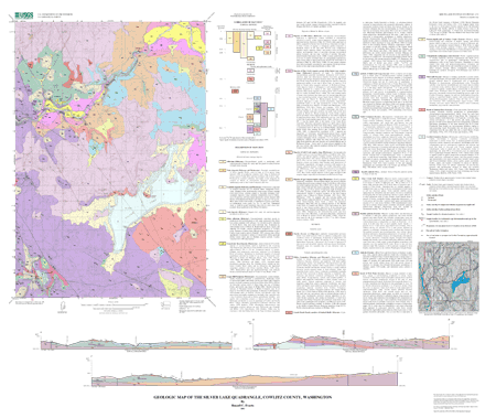
This database and accompanying plot files depict the distribution of geologic materials and structures at a regional (1:24,000) scale. The report is intended to provide geologic information for the regional study of materials properties, earthquake shaking, landslide potential, mineral hazards, seismic velocity, and earthquake faults. In addition, the report contains new information and interpretations about the regional geologic history and framework. However, the regional scale of this report does not provide sufficient detail for site development purposes. In addition, this map does not take the place of fault-rupture hazard zones designated by the Oregon State Geologist. Similarly, the database cannot be used to identify or delineate landslides in the region.

How was the data set created?

  1. From what previous works were the data drawn?
    Roberts (1958) (source 1 of 2)
    Roberts, A.E., 1958, Geology and coal resources of the Toledo-Castle Rock district, Cowlitz and Lewis Counties, Washington: U.S. Geological Survey Bulletin 1062.

    Type_of_Source_Media: paper
    Source_Scale_Denominator: 62500
    Source_Contribution:
    Comprehensive investigation of geology of the Castle Rock- Toledo coal district
    Phillips (1987) (source 2 of 2)
    Phillips, W.M. (compiler), 1987, Geologic map of the Mount St. Helens quadrangle, Washington: Washington Division of Geology and Earth Resources Open-File Report 87-4.

    Type_of_Source_Media: paper
    Source_Scale_Denominator: 100000
    Source_Contribution:
    The more detailed work described herein requires revisions to both Roberts' (1958) formal and Phillips' (1987) informal lithostratigraphic schemes for the Silver Lake quadrangle. The results show that the distribution of lithologic units in the Silver Lake quadrangle as portrayed by Roberts (1958) is essentially correct, although stratigraphic relations are more complex than he believed. The present work does not support Phillips' (1987) subdivision of his Goble Volcanics, but does confirm his age assignments.
  2. How were the data generated, processed, and modified?
    Date: 2000 (process 1 of 3)
    Field investigation and supporting geological analyses by the author over a period of years.
    Date: 2000 (process 2 of 3)
    The databases in this report were compiled in ARC/INFO, a commercial Geographic Information System (Environmental Systems Research Institute, Redlands, California), with version 3.0 of the menu interface ALACARTE (Fitzgibbon and Wentworth, 1991, Fitzgibbon, 1991, Wentworth and Fitzgibbon, 1991). The files are in either GRID (ARC/INFO raster data) format or COVERAGE (ARC/INFO vector data) format. Coverages are stored in uncompressed ARC export format (ARC/INFO version 7.x). ARC/INFO export files (files with the .e00 extension) can be converted into ARC/ INFO coverages in ARC/INFO (see below) and can be read by some other Geographic Information Systems, such as MapInfo via ArcLink and ESRI's ArcView (version 1.0 for Windows 3.1 to 3.11 is available for free from ESRI's web site: http://www.esri.com). The digital compilation was done in version 7.1.1 of ARC/INFO with version 3.0 of the menu interface ALACARTE (Fitzgibbon and Wentworth, 1991, Fitzgibbon, 1991, Wentworth and Fitzgibbon, 1991). The geologic map information was digitized from stable originals of the geologic maps at 1:24,000 scale. The author manuscripts (pen on mylar and pen on paper) were scanned using a Anatek rasterizing color scanner with a resolution of 600 and 400 dots per inch. The scanned images were vectorized and transformed from scanner coordinates to projection coordinates with digital tics placed by hand at quadrangle corners. The scanned lines were edited interactively by hand using ALACARTE, color boundaries were tagged as appropriate, and scanning artifacts visible at 1:24,000 were removed.
    Date: 23-Mar-2001 (process 3 of 3)
    Creation of original metadata record Person who carried out this activity:
    United States Geological Survey
    Attn: Karen L. Wheeler
    Menlo Park, California

    650-329-4935 (voice)
    650-329-4936 (FAX)
    kwheeler@usgs.gov
  3. What similar or related data should the user be aware of?

How reliable are the data; what problems remain in the data set?

  1. How well have the observations been checked?
  2. How accurate are the geographic locations?
  3. How accurate are the heights or depths?
  4. Where are the gaps in the data? What is missing?
  5. How consistent are the relationships among the observations, including topology?

How can someone get a copy of the data set?

Are there legal restrictions on access or use of the data?
Access_Constraints: None
Use_Constraints:
Uses of this digital geologic map should not violate the spatial resolution of the data. Although the digital form of the data removes the constraint imposed by the scale of a paper map, the detail and accuracy inherent in map scale are also present in the digital data. The fact that this database was edited for a scale of 1:24,000 means that higher resolution information is not present in the dataset. Plotting at scales larger than 1:24,000 will not yield greater real detail, although it may reveal fine-scale irregularities below the intended resolution of the database. Similarly, where this database is used in combination with other data of higher resolution, the resolution of the combined output will be limited by the lower resolution of these data.
  1. Who distributes the data set? (Distributor 1 of 1)
    Database Coordinator
    U.S. Geological Survey
    345 Middlefield Rd., M/S 975
    Menlo Park, CA
    USA

    650-329-4935 (voice)
    650-329-4936 (FAX)
    kwheeler@usgs.gov
  2. What's the catalog number I need to order this data set? USGS Miscellaneous Field Studies Map MF-2371
  3. What legal disclaimers am I supposed to read?
    Any use of trade, product, or firm names is for descriptive purposes only and does not imply endorsement by the U.S. Government. Although this publication has been subjected to rigorous review and is substantially complete, the USGS reserves the right to revise the data pursuant to further analysis and review. Furthermore, it is released on condition that neither the USGS nor the United States Government may be held liable for any damages resulting from its authorized or unauthorized use.
  4. How can I download or order the data?
    • Availability in digital form:
      Data format: Digital database files. 18 ARC/INFO export (.e00) files, along with supporting readme, plotfiles, revisions list, metadata, and import AML. in format ARCE (version 7.2.1) Size: 21.6
      Network links: http://pubs.usgs.gov/mf/2001/2371/2371db.tar.gz
    • Cost to order the data: none


Who wrote the metadata?

Dates:
Last modified: 13-Jun-2016
Last Reviewed: 21-Aug-2001
Metadata author:
Peter N Schweitzer
USGS Midwest Area
Collection manager, USGS Geoscience Data Clearinghouse, http://geo-nsdi.er.usgs.gov/
Mail Stop 954
12201 Sunrise Valley Dr
Reston, VA
USA

703-648-6533 (voice)
703-648-6252 (FAX)
pschweitzer@usgs.gov
Metadata standard:
Content Standard for Digital Geospatial Metadata (FGDC-STD-001-1998)

This page is <https://geo-nsdi.er.usgs.gov/metadata/map-mf/2371/metadata.faq.html>
Generated by mp version 2.9.48 on Tue Jul 03 20:05:09 2018