Geologic map of the Jasper quadrangle, Newton and Boone Counties, Arkansas

Metadata also available as - [Outline] - [Parseable text] - [XML]

Frequently anticipated questions:


What does this data set describe?

Title:
Geologic map of the Jasper quadrangle, Newton and Boone Counties, Arkansas
Abstract:
This digital geologic map compilation presents new polygon (i.e., geologic map unit contacts), line (i.e., fault, fold axis, and structure contour), and point (i.e., structural attitude, contact elevations) vector data for the Jasper 7 1/2' quadrangle in northern Arkansas. The map database, which is at 1:24,000-scale resolution, provides geologic coverage of an area of current hydrogeologic, tectonic, and stratigraphic interest. The Jasper quadrangle is located in northern Newton and southern Boone Counties about 20 km south of the town of Harrison. The map area is underlain by sedimentary rocks of Ordovician, Mississippian, and Pennsylvanian age that were mildly deformed by a series of normal and strike-slip faults and folds. The area is representative of the stratigraphic and structural setting of the southern Ozark Dome. The Jasper quadrangle map provides new geologic information for better understanding groundwater flow paths in and adjacent to the Buffalo River watershed.
Supplemental_Information:
The current map database incorporates geologic data from: (1) early geologic mapping (1906) by Purdue and Miser and (2) more recent field mapping (1995-1998) by M.R. Hudson. Buffalo National River, under the auspices of the National Park Service, occupies the central part of the map area.
FILES INCLUDED WITH THIS DATA SET:
jsp24k:        geology polygon coverage
jsppnt:        strike/dip point locations and data
jspcontrol:    field elevation control points
jspcontour:    structure contours on the top of the Boone Formation
geoscamp1.lin: geologic line symbols
geoscamp1.mrk: geologic marker symbols
fnt037:        font used with geoscamp1.mrk
wpgcmykg.shd:  shadeset used to color polygons in jsp24k coverage
fnt027:        font containing geologic age symbols
  1. How might this data set be cited?
    Hudson, Mark R., Murray, Kyle E., and Pezzutti, Deborah, 2001, Geologic map of the Jasper quadrangle, Newton and Boone Counties, Arkansas: Miscellaneous Field Sudies Map MF-2356, U.S. Geological Survey, Denver, Colorado.

    Online Links:

  2. What geographic area does the data set cover?
    West_Bounding_Coordinate: -93.250
    East_Bounding_Coordinate: -93.125
    North_Bounding_Coordinate: 36.125
    South_Bounding_Coordinate: 36.000
  3. What does it look like?
    http://pubs.usgs.gov/mf/2001/mf-2356/mf-2356.pdf (PDF)
    Printable digital representation of the entire map sheet, 3.4 megabytes.
    http://pubs.usgs.gov/mf/2001/mf-2356/mf-2356.gif (GIF)
    Reduced-size image of the entire map sheet, 288x260 pixels, 32-bit RGB true color, 40k bytes.
  4. Does the data set describe conditions during a particular time period?
    Calendar_Date: 2000
    Currentness_Reference:
    publication date
  5. What is the general form of this data set?
    Geospatial_Data_Presentation_Form: Map
  6. How does the data set represent geographic features?
    1. How are geographic features stored in the data set?
      This is a Vector data set.
    2. What coordinate system is used to represent geographic features?
      The map projection used is Polyconic.
      Projection parameters:
      Longitude_of_Central_Meridian: -93.1875
      Latitude_of_Projection_Origin: 36.0
      False_Easting: 0.000
      False_Northing: 0.000
      Planar coordinates are encoded using coordinate pair
      Abscissae (x-coordinates) are specified to the nearest 15
      Ordinates (y-coordinates) are specified to the nearest 15
      Planar coordinates are specified in METERS
      The horizontal datum used is North American Datum of 1927.
      The ellipsoid used is Clarke 1866.
      The semi-major axis of the ellipsoid used is 6378206.4.
      The flattening of the ellipsoid used is 1/294.98.
  7. How does the data set describe geographic features?
    Entity_and_Attribute_Overview:
    The complete geologic map database comprises four component ArcINFO coverages (jsp24k, jsppnt, jspcontrol, and jspcontour). The jsp24k coverage contains all contact lines and label points for each of the map polygons. The jsppnt coverage includes point data that represents bedding attitude and descriptive symbology for the jsp24k coverage fault lines. The jspcontrol coverage contains point data that represents elevation control points used by the geologist during field mapping. The jspcontour coverage contains elevations of the base of the Boone Formation.
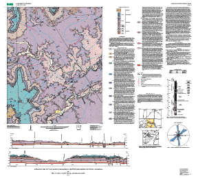
    DATABASE STRUCTURE - ARC/INFO ====================================
    
    Jasper Geology Coverage (jsp24k)
    
    AAT
    
    The arc attribute table contains two user-defined items:
    
    Item name	width   output 	type
    DESCRIPTION  	25       25	c
    LINECODE      	 5        5 	n
    
    The item 'LINECODE' contains the number that corresponds to
    a line symbol in ArcInfo lineset carto.lin
    
    contact = 1
    quad boundary = 1
    cross-section = 18
    exposed fault = 102
    inferred fault = 110
    concealed fault = 149
    
    PAT
    
    The polygon attribute table contains four user-defined items:
    
    Item name	width   	output   	type
    GEOLOGY      	10       	10       	C
    COLOR	      	 3        	 3       	N
    HATCH	     	10       	10       	I
    SPECGEO		10  	  	10 		C
    
    The item 'geology' corresponds to the geologic code (ex: Qty,
       Qto)
    The item 'color' corresponds to the appropriate number in the
       shadeset wpgcmykg.shd
    The item 'hatch' is used to specify the hatch marks required
       to plot Mbs units.  The item 'hatch' has a value of 29 for Mbs
       (corresponding to an appropriate hatch symbol in the shadeset
       plotter.shd) and a value of zero for every other geologic unit.
    The aml used to plot this map will shade the polygons using the
       item 'color' and the shadeset wpgcmykg.shd; selected polygons will
       be shaded a second time using the item 'hatch' and the
       shadeset plotter.shd.
    The item 'specgeo' is used to specify special geologic
       characters associated with the age of the lithologic units
       (ex: Pennsylvanian). These are plotted using font 027.
    
    Qty	Younger terrace and alluvium deposits (Holocene and late Pleistocene)
    Qto	Older terrace and alluvium deposits (Quaternary)
    Qc	Colluvial deposits (Quaternary)
    Pbu	Upper part of Bloyd Formation (Pennsylvannian)
    Pbl	Lower part of Bloyd Formation (Pennsylvanian)
    Phg	Prarie Grove Member of Hale Formation (Pennsylvanian)
    Phc	Cane Hill Member of Hale Formation (Pennsylvanian)
    Mp	Pitkin Limestone (Mississippian)
    Mf	Main body of Fayetteville Shale (Mississippian)
    Mfw	Wedington Sandstone Member(Mississippian)
    Mbv	Batesville Sandstone(Mississippian)
    Mb	Main body of Boone Formation (Mississippian)
    Mbs	St. Joe Limestone Member (Mississippian)
    Of	Fernvale Limestone (Ordovician)
    Oe	Everton Formation (Ordovician)
    Op	Powell Dolomite (Ordovician)
    
    Jasper Strike-Dip Coverage (jsppnt)
    
    PAT
    
    The point attribute table contains 8 user defined items:
    
    Item name  	width   	output   	type
    DIP      	10	 	10      	I
    AZIMUTH      	8        	8      		I
    MARKER		10	 	10	   	I
    DESCRIPTION  	20		20		C
    ARROWAZ		4		4		I
    DIAMAZ		4		4		I
    ARROWDIP   	4 		4		I
    DIAMDIP		4		4		I
    
    The item 'dip' is the angle that the bed dips from the horizontal.
    The item 'azimuth' is the direction of strike of the bed using azimuthal
       measurements (N = 0, E = 90, S = 180, W = 270)
    The item 'marker' is used to specify the symbol from
       geoscamp1.mrk used for plotting.
    The item 'description' provides a brief explanation of the
       symbol type.
    The item 'arrowaz' is used to specify the azimuth of a fault
       dip.
    The item 'diamaz' is used to specify the azimuth of a fault rake.
    The item 'arrowdip' is used to specify the angle associated
       with a fault dip arrow symbol.
    The item 'diamdip' is used to specify the angle associated
       with a fault rake diamond symbol.
    
    
    Jasper Control Point Coverage (jspcontrol)
    
    PAT
    
    The point attribute table contains 2 user defined items:
    
    Item name  		width   	output   	type
    VALUE      		10	 	10      	I
    BOONE_FORM		10		10		C
    
    The item 'value' is used to specify the elevation of the control
       point in feet.
    The item 'boone_form' specifies either the top or bottom of the
       Boone Formation.
    
    
    Jasper Structure Contour Coverage (jspcontour)
    
    AAT
    
    The arc attribute table contains one user defined item:
    
    Item name		width   	output   	type
    CONTOUR			10		10		I
    
    The item contour contains a value for the elevation of the base
       of the Boone Formation, in feet above Mean Sea Level.
    
    Entity_and_Attribute_Detail_Citation: http://pubs.usgs.gov/mf/2001/mf-2356/mf-2356textonly.pdf

Who produced the data set?

  1. Who are the originators of the data set? (may include formal authors, digital compilers, and editors)
    • Hudson, Mark R.
    • Murray, Kyle E.
    • Pezzutti, Deborah
  2. Who also contributed to the data set?
    Funding for the project was provided by a U. S. Geological Survey project for cooperative work with the National Park Service. D.N. Mott and J.D. MacFarland, III, provided useful knowledge and discussion during the project.
  3. To whom should users address questions about the data?
    Mark R. Hudson
    U.S. Geological Survey
    Geologist
    Box 25046, MS980, Denver Federal Center
    Denver, CO
    USA

    303-236-7446 (voice)
    303-236-5349 (FAX)
    mhudson@usgs.gov, kmurray2@usgs.gov

Why was the data set created?

To provide a digital geologic map database of the quadrangle that improves understanding of the regional geologic framework and its influence on the regional groundwater flow system.

How was the data set created?

  1. From what previous works were the data drawn?
  2. How were the data generated, processed, and modified?
    Date: 1999 (process 1 of 9)
    The original map data were manually transferred to separate stable mylar overlays registered to a stable-base USGS 7.5 minute topographic map.
    Date: 1999 (process 2 of 9)
    Mylar base materials were scanned at 300 dpi.
    Date: 1999 (process 3 of 9)
    TIFF files of the scanned map overlays were auto-vectorized using the LT4X CAD program, and the resulting vector files imported into ArcInfo.
    Date: 2000 (process 4 of 9)
    Text map unit descriptors were added to the .AAT and .PAT database files for each coverage.
    Date: 2000 (process 5 of 9)
    Draft check plots of the geologic map and explanation were created and submitted for peer review. Geologists reviewed the plots for conformity with U.S. Geological Survey editorial standards and stratigraphic nomenclature. Revisions were made to the geospatial database as needed.
    Date: 28-Feb-2000 (process 6 of 9)
    First draft of metadata created using FGDCMETA.AML ver. 1.2 05/14/98 on ARC/INFO data set jsp24k
    Date: 2000 (process 7 of 9)
    The database files, metadata, and check plots were edited by the USGS Central Publications Group, and revisions made to the geospatial database and metadata as needed.
    Date: 2000 (process 8 of 9)
    The geospatial database files and metadata were quality checked for completeness and consistency.
    Date: 17-Nov-2000 (process 9 of 9)
    Creation of original metadata record Person who carried out this activity:
    Mark Hudson
    U.S. Geological Survey
    MS 980, Box 25046 Denver Federal Center
    Denver, CO

    303-236-7446 (voice)
    mhudson@usgs.gov
  3. What similar or related data should the user be aware of?

How reliable are the data; what problems remain in the data set?

  1. How well have the observations been checked?
    Attributes were checked by manually comparing hard copy plots of the digital data with the source materials. Authors and USGS map editors performed separate reviews.
  2. How accurate are the geographic locations?
    The data were created by delineating the boundaries from scale-stable overlays on a USGS 7.5-minute topographic map at 1:24000 scale. Stable overlays were scanned at a resolution of 300 dots per inch. Potential exists for errors in location by the geologist in the field but many locations of many contacts were aided at control sites by use of a global positioning receiver with typical horizontal accuracies less than 20 m or by use of a barometric altimeter with vertical resolution of about 6 m tied to topographic contours with vertical accuracy of about 6 m.
  3. How accurate are the heights or depths?
  4. Where are the gaps in the data? What is missing?
    Geologic map units were collected and digitized at appropriate resolution for portrayal on a base at 1:24000 scale. Data are complete: no features were eliminated or generalized.
  5. How consistent are the relationships among the observations, including topology?
    Map elements were visually checked by the authors for overshoots, undershoots, duplicate features, and other errors. ARC/INFO software was used to create topological relations among features. Features were not duplicated, but coincident lines exist between data layers where appropriate.

How can someone get a copy of the data set?

Are there legal restrictions on access or use of the data?
Access_Constraints: none
Use_Constraints:
None. Acknowledgment of the U. S. Geological Survey would be appropriate in products derived from these data.
  1. Who distributes the data set? (Distributor 1 of 1)
    U.S. Geological Survey
    Central Publications Group
    U.S. Geological Survey
    MS 902, Box 25046 DFC
    Lakewood, CO

    303-236-5486 (voice)
  2. What's the catalog number I need to order this data set? USGS Miscellaneous Field Studies Map MF-2356
  3. What legal disclaimers am I supposed to read?
    Although this digital spatial data has been subjected to rigorous review and is substantially complete, it is released on the condition that neither the USGS nor the United States Government may be held liable for any damages resulting from its authorized or unauthorized use.
  4. How can I download or order the data?
    • Availability in digital form:
      Data format: Geologic units and structural features in format ARCE, Shapefile (version 7.1.2)
      Network links: http://pubs.usgs.gov/mf/2001/mf-2356/
    • Cost to order the data: none


Who wrote the metadata?

Dates:
Last modified: 10-Jun-2016
Last Reviewed: 21-Jan-2002
Metadata author:
Peter N Schweitzer
USGS Midwest Area
Collection manager, USGS Geoscience Data Clearinghouse, http://geo-nsdi.er.usgs.gov/
Mail Stop 954
12201 Sunrise Valley Dr
Reston, VA
USA

703-648-6533 (voice)
703-648-6252 (FAX)
pschweitzer@usgs.gov
Metadata standard:
Content Standard for Digital Geospatial Metadata (FGDC-STD-001-1998)

This page is <https://geo-nsdi.er.usgs.gov/metadata/map-mf/2356/metadata.faq.html>
Generated by mp version 2.9.48 on Tue Jul 03 20:05:06 2018